Today’s hike on Gran Canaria through the Inagua nature reserve begins and ends with a walk through an impressive steep face. If you look up from the starting point, the Degollada de Aldea, you won’t believe that there is a path leading up there. The path follows the rocky outcrop and will lead you through a side valley up to the El Laurelillo plateau and into the nature reserve. Fantastic views around the peaks of Inagua, Montaña Ojeda and Degollada de las Brujas on the island of Gran Canaria are guaranteed.
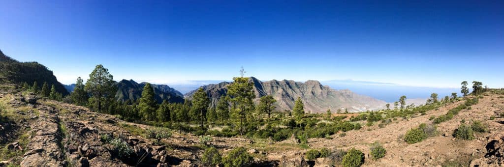
Gran Canaria - Panorama on the plateau of El Laurelillo
Map
Hiking in the nature reserve Inagua on Gran Canaria
Gran Canaria has more than 30 nature reserves with a total area of 66707 hectares. This means that the nature reserves cover almost half of the island’s surface area (42%). They serve the conservation of biological diversity. In June 2005, a large part of the western part of Gran Canaria was additionally recognised as a World Biosphere Reserve. UNESCO not only wants to protect nature, but also cultural resources and cultural landscapes. The large Inagua nature reserve of 3920 hectares, bordering the municipalities of Tejeda, Mogán and Aldea, has the highest level of protection.
It is a protected area for a variety of endemic animal and plant species. In the Inagua, geological and geomorphological peculiarities can be found, which indicate the origin of the Canary Island Gran Canaria. There are also archaeological sites of cave villages in the old Canary Islands. There were found stone circles and stone turrets, which could be connected with religious or astronomical activities. Also cult and tombs are suspected in the Inagua on Gran Canaria.
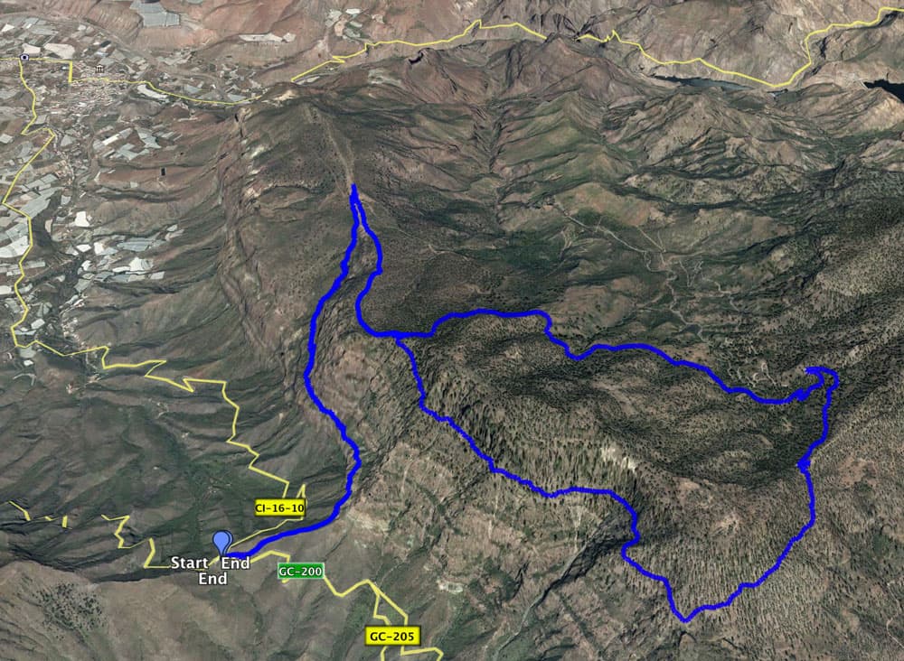
Track - Hiking Nature Reserve Inagua Gran Canaria
Information about the hike in Nature Reserve Inagua in Gran Canaria
Starting point Degollada de la Aldea (642 m altitude) Gran Canaria
Data: 27.938227, -15.760515
Arrival by car
Access is via the island road GC-200 from Puerto Mogán to La Aldea de San Nicolas. The Degollada de la Aldea is located at the junction of the road to Tasártico (GC-204) at KM 42.6. Parking is available on the broad roadside at the Degollada de la Aldea.
Arrival by bus
With the bus you get with the line 38 (Puerto de Mogán – La Aldea de San Nicolas) to the Degollada de Aldea, where there is a bus stop. Further information on the Guaguasglobal Homepage. Time
The walking time is about 6,5 hours. As always, this information is relative, as each person has his own speed. Those who walk through quickly will certainly manage the distance faster. And if you want to enjoy and watch more, you can certainly use a little more time.
Route length
The hike is about 17.5 kilometres long.
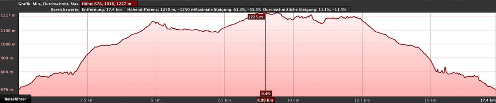
Elevation profile hike Nature Reserve Inagua Gran Canaria
Difference in altitude
Article summary and large selection of GPS hiking tracks
Sign up for my newsletter now and get exclusive access to my collected GPS tracks as well as all the brief information about my articles.
Sign up nowThe descent and ascent is 560 metres in altitude. But absolutely there are about 820 meters of altitude to climb and descend on this route.
Requirements
In the ascent and descent and in the part from El Castillete to El Laurelillo, sure-footedness and a head for heights on the narrow paths are absolutely essential. The rest of the route is easy. All in all, this is a long and strenuous hike that requires a little physical fitness. Please take enough water and provisions with you, as there is really no place to stop for refreshments along the way.
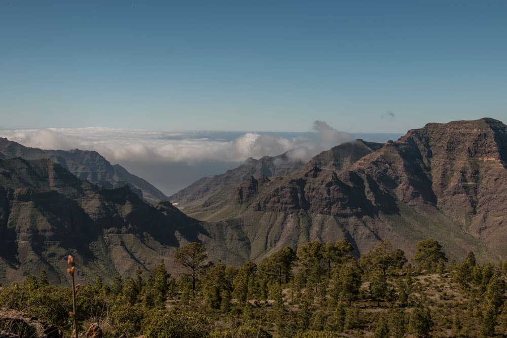
View from the hight Inagua above the clouds
Variants – hiking Gran Canaria
As a large part of this tour is a circular path, it goes without saying that you can of course also go in the other direction for this part of the hike.
The tour is quite long with more than 17 kilometres. Those who find it too long will also enjoy hiking „only“ from the Degollada de la Aldea up to the plateau El Laurelillo. An impressive tour with magnificent views.
Who likes to avoid the big round around the summit of the Inagua and the Montaña Obeja and simply hikes a little on the plateau. There are many beautiful corners and vantage points to discover in all directions.
IMPORTANT
From June to October it is forbidden to enter the protected area, as the endemic blueink (Pinzón Azul), which is threatened with extinction, breeds there. The ascent and descent from the Degollada de la Aldea to the El Laurelillo plateau is still possible.
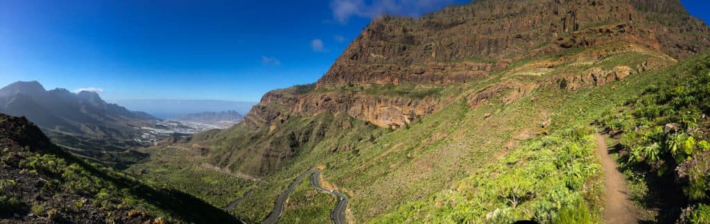
Panorama view on the hiking path to the steep face above the Degollada de Aldea
Gran Canaria – Hike Degollada de la Aldea via El Laurelillo and Degollada de las Brujas and back via El Castillete
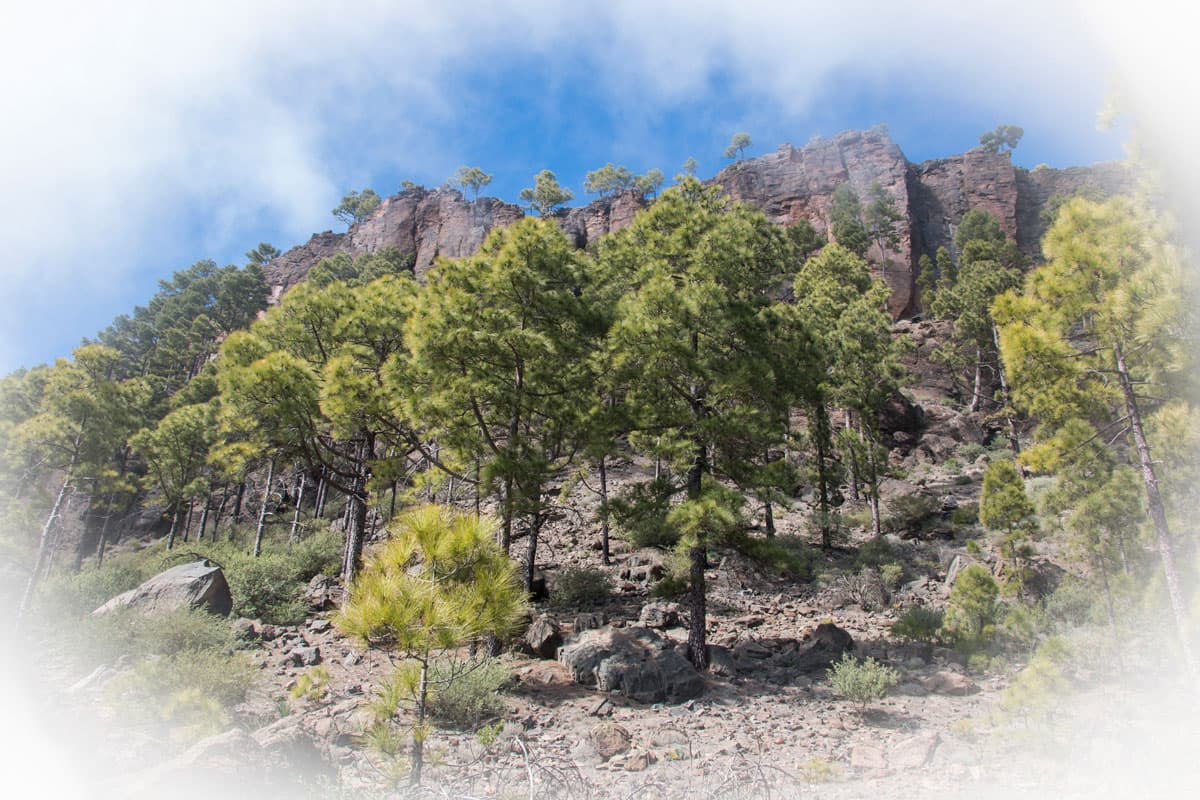
Hiking route from Degollada de la Aldea along the rock face
The trail starts at the Degollada de la Aldea. The bus stops here and there is enough space to park your car. You cross the road and can’t miss the small path uphill. The road to Mogán runs right below you. After a short time you reach a small plateau and change with the hiking path to the other side of the slope. Now you can see the road to Aldea below you. Approximately 20 minutes after the start of the tour, the hiking trail, which runs towards the steep face, takes you to a fork in the road.
There you turn left. Now you are directly below the big steep rock face rising into the sky. The path continues under and along the rock face. It is rocky and from time to time you have to climb over some big rocks. After about half an hour the path leads over rock slabs. The path over the rock slabs is signposted by small cairns. Just hold yourself diagonally upwards over the rock plateau. At the end the trail continues clearly.
Gran Canaria - view from Inagua direction east
Hiking route rock face to the plateau El Laurelillo
After you have walked over the small rock plateau, the path continues clearly visible below and along the rock face. After some time you will reach a small side gorge. Here the path continues to the right. It climbs steeply in small serpentines – sometimes connected with a bit of scrambling – parallel to the gorge. At the edge you pass pines and big boulders.
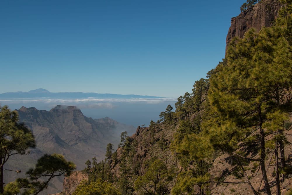
After about three quarters of an hour, which leads you further north uphill, the path becomes less steep and the terrain becomes a little flatter. At a small fork, keep right. Now it’s not far and you climb the last few metres up to the El Laurelillo plateau. From the Degollada de la Aldea you have already left 320 meters of altitude behind you. You will be compensated up there with wonderful views.
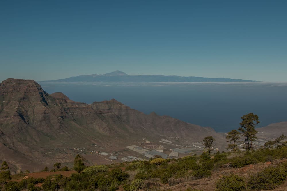
view from the hight to the valley of Aldea - in the background Tenerife and Teide
Hiking route from El Laurelillo towards Inagua
Article summary and large selection of GPS hiking tracks
Sign up for my newsletter now and get exclusive access to my collected GPS tracks as well as all the brief information about my articles.
Sign up nowThe El Laurelillo plateau not only offers you fascinating views, but there are also many different hiking trails from up here that go in all directions. However, this does not make it easy to find the right path. And I admit that I did not find it during my first hike to the nature reserve Inagua. At that time we came across a parallel path that ran a little downhill towards the east. This route was also impressive and interesting. But unfortunately not the round tour around the peaks of Inagua and Montaña Ojeda.
That should not happen to you. You’ll find the right way close to the edge where you climbed (i.e. towards the west). There is a narrow path leading south. A sign indicates the beginning of the Inagua Pajonales nature reserve. You will see the summit of Inagua directly in front of you. Even if it is surrounded by clouds from time to time. Now it goes through pine forests, which continue up to the summit of the Inagua mountain.
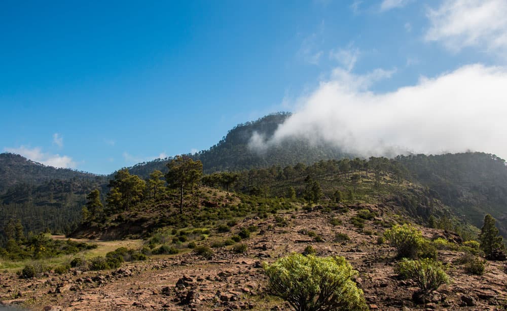
View of the cloudy summit of the Inagua from Laurelillo
Hiking route from the edge of the pine forest to the forest path
When you reach the pine forest, the path gets steeper. After all, it’s uphill in serpentines. Keep left at the first fork. A short time later you come to a second fork. Here you keep left again. This is also where the circular path begins around the Inagua and Montaña de Ojeda peaks. Now you are already at 1,160 metres above sea level.
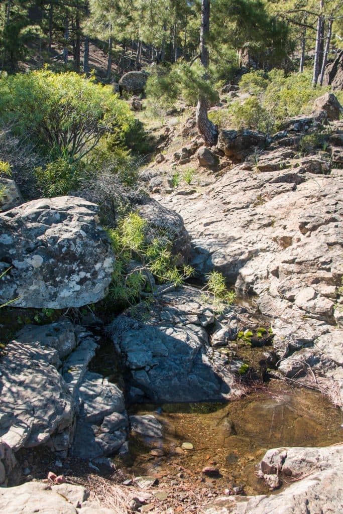
Now the path becomes easier. It takes you up and down easily around the summit of Inagua. On the forest path it is pleasantly shady and wonderfully comfortable to walk. From time to time there are wonderful views of the east of the island between the pines. The path leads you past a small stream, which is ideal for a picnic. Through bushes you then go through a small depression onto a forest path.
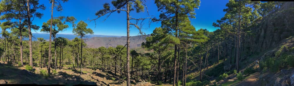
Gran Canaria - hiking through pine forests
Hiking trail Forest path to Degollada de las Brujas
On the wide forest track you then go in a large curve to the opposite side of the slope. From there, it takes about 20 minutes to go up the slope in large hairpin bends and serpentines. Then you reach a small plateau where several hiking trails and forest tracks cross again. This is the pass Degollada de las Brujas (witch pass). Here you have reached the highest point of the hike at an altitude of 1200 metres.
I didn’t see any witches there, but I enjoyed a great view in all directions of Gran Canaria. Up there, walking is not so easy, as all hiking trails are well signposted. To the right there are three paths. One of them leads to the top of the mountain. Thus, those who still have time can make a small side trip up here. The southern path of these three hiking paths that lead around to the right is the right hiking path to continue the circular path.
view from the break off edge at El Castillete on the Degollada de Aldea
Hiking route Degollada de las Brujas via Roque el Castillete to the edge of the abort
The trail leads you southwest, first downhill, through pine forest on the eastern side of the Montaña Ojeda, up and down. In about half an hour you will see a transmission mast on a mountain peak in front of you. This is the Roque el Castillete. Here you have reached the southernmost point of the hike at 1,160 metres above sea level.
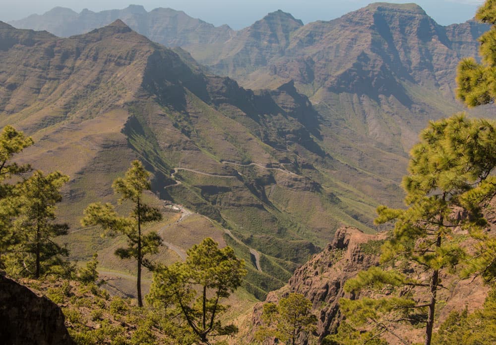
Now you continue on the western side of the Montaña de Ojeda. The way is a little narrow from time to time, so that a head for heights and a sure-footedness are absolutely advantageous. From the hiking path, there are now wonderful views to the whole west of the island. Provided that there are no clouds in the suit that could take your view. The path now runs directly along the edge of the steep cliffs.
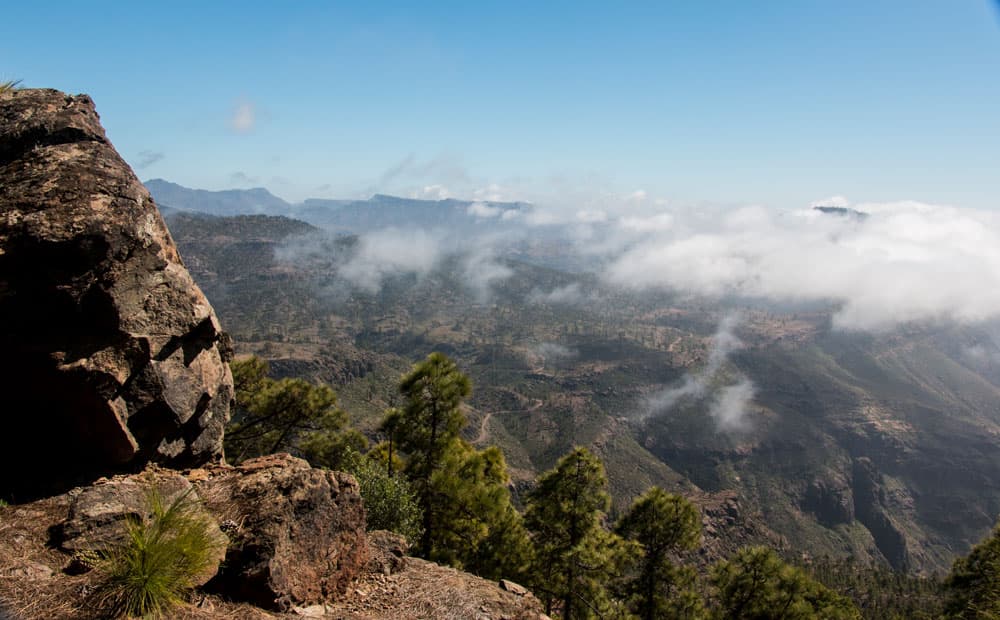
view from the Degollada de las brujas to the south part of Gran Canaria
Hiking route from the edge of the abyss to the El Laurelillo plateau
The narrow footpath leads along the edge of the abort towards the northwest. It alternates between a gentle uphill and then downhill again. The path adapts exactly to the mountains and follows the incisions of the mountains. It goes west along the Montaña de Ojeda and then along the Inagua mountain.
After about 30-40 minutes you will come back to the point in the pine forest where your circular trail started. Now keep to the left. The trail leads you downhill. And after about half an hour you are back on the El Laurelillo plateau. From there you take the path you climbed here. The path takes you back to Degollada de la Aldea.
View from the break off edge behind El Castillete to Tenerife and Teide
And finally
I hope you enjoyed today’s tour and wish you much pleasure in discovering the Inagua Nature Reserve in Gran Canaria.
Dagmar von SiebenInseln