Hike to the dream beach Güi Güi connects mountains and sea
Today’s walk to Güi Güi beach shows you a very special side of Gran Canaria. Gran Canaria is known by tourists for its sun, beach and exuberant carnival.

lonely beach Güi Güi
So many visitors who spend their holidays in the hotels on the coast know nothing about the impressive landscape that Gran Canaria has to offer.
Map
Aldea_dTrack Degollada_Güi Güi Tasártico Güi Güi
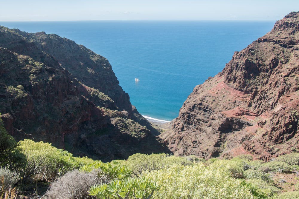
A very special hike, where you have the opportunity to combine a fascinating mountain hike with a very special beach stay, is the hike to the lonely beach Güi Güi. Away from the crowds of people in Maspalomas, the hike in the western part of Gran Canaria takes you along steep mountain paths and untouched gorges to the remote beach Güi Güi. You can only get to this beach by water or on narrow steep paths over the mountains. I will show you two ways to get over the mountains to the secluded beach Güi Güi.
Playa Güi Güi – a fine sandy dream beach in a lonely bay
Two beaches in beautiful bays – Playa Güi Güi and Playa Chico

people at the sandy beach Güi Güi
First of all I would like to tell you a little about today’s destination – the lonely sandy beach Güi Güi. Strictly speaking, it is two beaches lying next to each other in high rocky bays. The hiking trail ends at the so-called big beach Güi Güi (Playa Grande). Right next to it in the neighbouring bay is the beach Güi Güi Chico, which is separated from Güi Güi Grande only by a rocky outcrop. There is a connection of both beaches on foot only at low tide. Then you can easily walk from one beach to the other.
But those who visit Playa Chico have to make sure that they can come back in time with dry feet. The beach Güi Güi Chico with its length of 850 metres is more than twice as long as the Güi Güi Grande. Both beaches are surrounded by high cliffs that rise more than 500 metres into the sky. These give at any time of the day at the edge of the beach a little shade. In winter, the sand is often removed from the beaches, which are then covered only with large pebbles. In spring the sand is washed up again.
Playa Güi Güi then and now

Güi Güi cliffs
The nature reserve of Güi Güi today was already a popular place for hippies in the 60s and 70s with its two beaches. A small colony of drop-outs is said to have lived here for a long time. Since no infrastructure was available and is almost still not today, everything that humans need to live has to be brought to them. During my stay at Playa Güi Güi five years ago, a young couple told me that they would spend some weeks away from the world together with four other young people. From time to time, two of them would head for civilisation to buy the necessary food on the other side of the Degollada de la Agua. There is a water source in the Barranco Güi Güi. But the rest of the food has to be carried with muscle power or through the water.

Güi Güi beach
Even though on Gran Canaria wild camping is generally forbidden, here at the beach, the tents are pitched again and again for a short or longer time. From everywhere people are attracted to the untouched beach, who want to stay at least one night, but possibly also a little longer. On weekends or holidays, the beach is still a popular meeting place for young Canarians who like to escape civilization for a few hours. Everyone knows that wild camping is not only forbidden in the bay. The police, the Guardia Civil, often show presence with a boat in the bay. But the „small“ risk to be occupied with a high fine, they accept apparently all gladly for this mad nature experience.
Playa Güi Güi still something special

view from the degollada de los palos
During my last visit in February 2017, however, I noticed that a lot has changed on the beach since my last stay 5 years ago. At that time there was a small house near the beach that was fenced in and surrounded by a little garden. During the last years, some cottages have been added near the beach. New paths have emerged. There are better signs and even hints to a small café. Of course Playa Güi Güi is no longer an absolutely lonely beach where you won’t see any people for days. No, some people come there every day now. And in the bay, ships that come over from Puerto Mogán and Puerto Rico anchor to look at a little „loneliness“ from the water side.

tents at the Güi Güi beach
And yet Playa Güi Güi is still lonely and somehow special compared to the other crowded beaches. It is really worth the hike. If you like, you can still swim in the bays without bathing clothes. In the evening, when the day tourists have left again, it gets really quiet. To enjoy the view to Tenerife with the Teide or the sunset there at the beach is still something very special. The nature reserve of Güi Güi is protected as the ecologically sensitive area is home to a large population of protected plants and birds.
Güi Güi is in fact more than just a beach. Not only are the sunsets fantastic, but life seems to be a little freer, at least for a short time.
General information
Hike
Tasártico – Playa de Güi Güi Grande via Degollada de Aguas Sabinas
Time
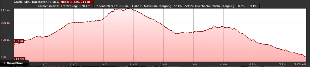
approx. 2.5 hours per way (if you stay one hour at the beach, plan at least 6 hours)
Route length
approx. 9 kilometres. Today the distance is shorter than a few years ago, because there is a direct way through a side gorge. Therefore, in older hiking guides a distance of more than 10 kilometres is indicated.
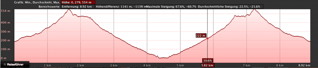
elevation profile Tasártico - Playa de Güi Güi
Difference in altitude
approx. 950 metres in ascent and descent

Panorama Barranco Güi Güi
Requirements
Exhausting hike, as there is hardly any shade. Think of enough water and provisions for the trail. No refreshment or shopping during the hike or on the beach (only at the beginning of the hike in Tasártico). Shortly before the beach I discovered a sign „Café“ at a hut in February 2017. But on the day I walked past there, nobody seemed to be „at home“. Hiking boots and if necessary hiking poles are absolutely necessary.
Starting point Tasártico (235 meters altitude difference)
Approach
There is no bus connection to Tasártico. Therefore it is only possible to reach Tasártico by car. Via the big island road GC-200 from Puerto Mogán to La Aldea de San Nicolas. At the Degollada de Aldea a small road, the GC-204, leads down the gorge towards the sea. A bus line 38 (Puerto de Mogán – La Aldea de San Nicolas) takes you to this junction (Degollada de Aldea). But from there it is still 7 kilometres to Tasártico. Those who do not want to drive by car stop will not have a real alternative with the bus journey. You can park your car below the village at the edge of the road Camino de la Playa Del Asno (dirt road). There is also the signposted start of the tour.
Article summary and large selection of GPS hiking tracks
Sign up for my newsletter now and get exclusive access to my collected GPS tracks as well as all the brief information about my articles.
Sign up now
Panorama hiking path to Güi Güi
Beach Playa Chico
Those who want to visit the beach Playa Chico from the beach Güi Güi Grande can do this at low tide. In about 20 minutes you can overwade to Playa Chico. Please make sure that you return in time. You can find the current tide times on the website. In Spanish, ebb tide means bajamar and flood pleamar. Hike: La Aldea de San Nicolás – Degollada de los Palos – possible Hike to Playa Güi Güi
Time
approx. 3.5 hours per way from Cuermeja near Aldea de San Nicolás to Degollada de los Palos – 2.5 hours longer to the beach
Length
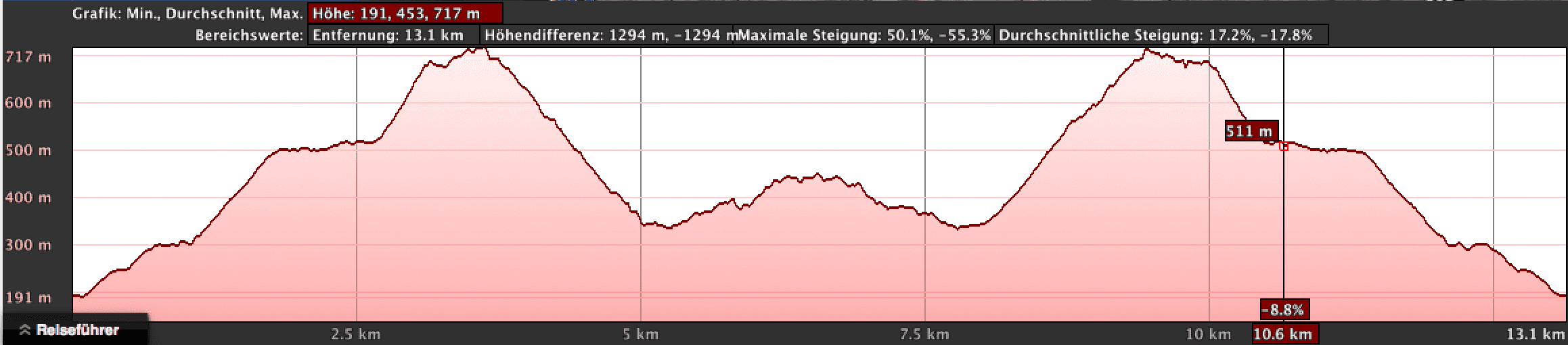
about 7 km to Degollada de los Palos (easy) and about 10 km to Playa Güi Güi (easy)
Track La Aldea de San Nicolás - Degollada de los Palos - from there you can hike to Güi Güi
Difference in altitude
approx. 1060 meters in ascent and descent to Degollada de los Palos (hike Cuermeja to Degollada de los Palo), Cuermeja to the beach of Güi Güi are 793 meters in descent and 525 meters in ascent (hike easy)
Track Aldea to Güi Güi
Requirements
Exhausting hike as there is little shade. Think of plenty of water and provisions. In the Barranco Güi Güi Chico and also near the beach Playa Güi Güi there is the possibility to fill up the water. There is no possibility to stop for refreshments and also no shopping possibility during the hike or at the beach (see above reference to the café at Playa Güi Güi). Hiking boots and hiking poles are absolutely necessary.

Barranco and mountains around Güi Güi
Start
Approach
With the bus (line 101) it is possible to go from the north of the island Galdár to La Aldea de San Nicolás. The bus (line 38) goes from Puerto de Mogán to La Aldea de San Nicolas. Starting point for the walk would then be at the main road GC-200. But also from there it is still a longer way up to the actual starting point of our walk in the small hamlet Cuermeja above Aldea de San Nicolás. Therefore, an approach by car is probably also indispensable for this variant.
From the main road GC-200 in La Aldea de San Nicolás direction harbour La Aldea a road branches off to the left direction Cuermeja. There is also a reference to Playa Güi Güi. The name of the street is Calle Subida a Cuermeja. You follow this street as long as there is still a road. This ends in the small hamlet of Cuermeja. There the hiking trail to the beach Güi Güi starts signposted. Parking is easily possible along the path.
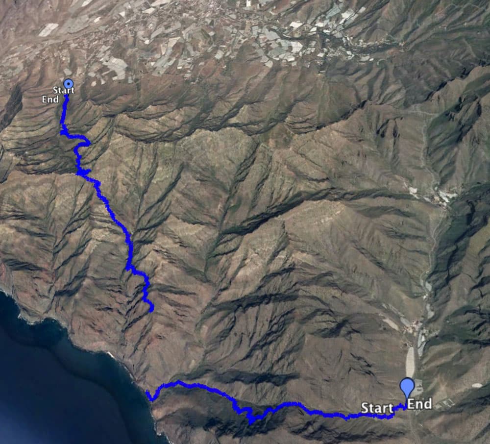
Combination of both hikes to Playa Güi Güi

Blue: Track Tasártico - Güi Güi orange: Track starting in Aldea
Those who want to hike to the beach Güi Güi should choose the first tour from the starting point Tasártico, because this hike can be done in 6 to 7 hours by staying at the beach. Variant 2 with start in Cuermeja is very scenic, but it is hardly suitable to walk back and forth in one day and still enjoy the beach. The walk alone takes 12 hours. Therefore, this variant is only recommended as one way. This also means that you can combine the two tours. The way there then leads you via tour 2 and the way back via tour 1 (or vice versa). Then you have to organize your private journey to the start and end point (Cuermeja and Tasártico). Because there are no bus connections.
I myself went from Cuermeja to the highest point of the hike of the Degollada de los Palos and then back again because the car was in Cuermeja. So I saved myself the trip down to the beach from this side. As the landscape around the steep cliffs and the gorges is unique, this hike is more than fascinating even without a stay at the beach.
Alternative approach by boat to the beach
Those who do not dare to do the difficult hike over the mountains and still want to visit the beach of Güi Güi can book a boat tour from Puerto Mogán and Puerto Rico. However, many tour providers only take the boat past the beach or anchor in the bay. Alternatively, you can look around for a private water taxi that can take small groups to Güi Güi beach. If you don’t want to hike, you will surely find some ways to get to the beach by water in the neighbouring harbour towns.
Hike Tasártico to the beach of Güi Güi
Hiking from Tasártico to Degollada de Aguas Sabinas

Track Tasásrtico - Güi Güi
Once you have parked your car below the small town of Tasártico in the Barranco Tasártico towards the sea, the hike can begin. To the right of the Camino de la Playa Del Asno gravel road, the trail climbs steeply up the slope behind a large greenhouse covered with tarpaulins. You can’t miss the path, as it is well marked with a stone man and a sign, as well as a reference to the nature reserve.
From the gravel road to the Pass de Aguas Sabinas, the trail climbs over 300 metres at the beginning of the hike. In Tasártico you already have an altitude of 235 metres and from there you climb up to the Degollada de Aguas Sabinas at 547 metres, mostly in glistening sunshine.

Degollada de Aguas Sabinas
In the beginning it is still moderate in some wide serpentines around rocks and valley incisions. To the right and to the left large rock massifs rise into the sky. The higher you climb, the narrower the valley becomes. The path also becomes steeper and the last 20 minutes to the pass require a little more strength and energy. But after about an hour you have made it. From the saddle of the Degollada de Aguas Sabinas you have a fascinating view of the towering rock massifs and the Atlantic Ocean. Back you look at the valley around Tasártico with its large greenhouses. An ideal place for a little rest and a fantastic panoramic view.

Track Tasártico Sabinas Güi Güi
From the Degollada de Aguas Sabinas to the beach of Güi Güi

hiker on the path
The next 1.5 hours after this strenuous ascent, we continue in a very relaxed manner. On a beautiful panoramic path, a small path leads you along the slope at the same height. The Barranco of Güi Güi now spreads out below you. Then it goes in numerous wide serpentines constantly downhill. The path continues through the rocky Barranco from Güi Güi towards the sea.
At the bottom of the gorge it becomes a little greener with palm trees and many cacti. In between there are many green shrubs. During my last visit in February 2017 even whole bee colonies hummed around us.

Barranco path with hiker and dog
New way
Article summary and large selection of GPS hiking tracks
Sign up for my newsletter now and get exclusive access to my collected GPS tracks as well as all the brief information about my articles.
Sign up nowOnly five years ago the way led down the slope with a wide arc through the valley and then continued towards the beach. Today there is a shorter way directly down through a small side gorge.

signpost to the beach

the hiking path to Güi Güi
After you have left the slope with its numerous wide serpentines behind you, the path runs straight for a while. Then you’ll see a large wooden signpost showing you the way to the beach, which turns to the left of the main path. From here it is 1.2 kilometres to Playa Güi Güi. It goes down the narrow path and rocks the gorge for a while. Then you pass the first lonely huts. The smell of salt and the sound of the sea signal that the beach is not far away anymore.

hermitage close to the beach
The last part of the path then leads left through the valley towards the beach. At the top left on the rocks are the ruins.
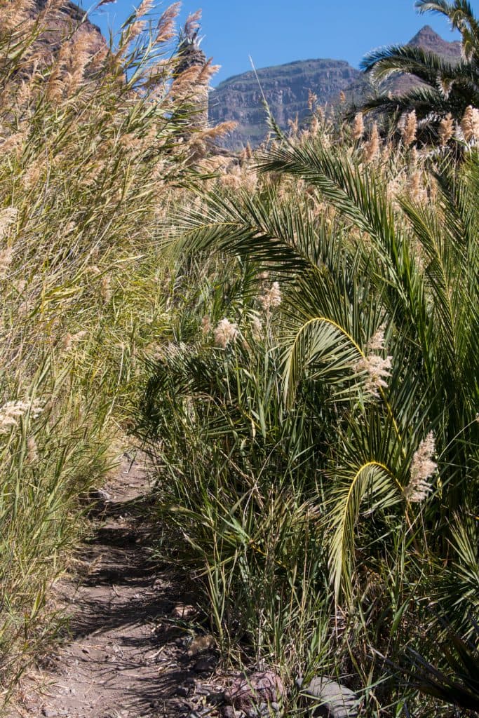
Reed, path and a waterhole
On the right side, after a section full of reeds, there is still the small „homestead“ that stood there 5 years ago. The last meters after the house it goes down immediately quite steeply on rock and sand to the beach. You are there and can rest on the beach and enjoy a swim in the waves of the Atlantic Ocean to cool off.

ruins above the beach of Güi Güi
Hike from Aldea de San Nicolas (Cuermeja) to Degollada de los Palos towards Playa Güi Güi
Hike through the Barranco of Aldea de San Nicolas (Cuermeja)

Track from Cuermeja via Aldea de San Nicolás to the Degollada de los Palos
Whether you decide to make the hike from the hamlet of Cuermeja a long way to the beach of Güi Güi or whether you just want to do a wonderful mountain tour to the Degollada de los Palos, you start at the signposted path to Güi Güi in the hamlet of Cuermeya above Aldea de San Nicolás.
The small village of Cuermeja lies at an altitude of almost 200 metres. In the first part of this hike through a wide gorge you will have to climb about 500 meters.

Aldea de San Nicólas
Walking uphill
The path takes you uphill for over an hour, first on the left side of the gorge. From time to time the path climbs a bit steeply and then continues over long stretches. You pass several lonely farmsteads. Some of them are inhabited and others only ruin houses. In order to reach further height the way leads partly in wide serpentines around side gorges. Often it goes through dense green. After about an hour you reach the end of the wide gorge. Now it goes on a small narrow path on narrow serpentines steeply up the mountain. Partly the path is overgrown. In the early morning it is even wet around you.

view to Tenerife
Now you also change to the right side of the gorge. After 1.5 hours the path leads you in a large arc over the left side of the gorge. Afterwards it goes over a panorama way along the mountain ridge on a small elevated plateau.

Clos to Cuermeja you will find some houses in the barranco
From here you have a fantastic view back to La Aldea de San Nicolás with its numerous banana plantations, the Atlantic Ocean and all surrounding mountain ranges. And on the horizon you can see Tenerife and the sharp profile of the volcano Teide. A really impressive vantage point, which is well suited for a small rest, but also for good photos. From this point it goes downhill.
Hike through the green gorge – Barranco Chico

path from the hight into the barranco chico
At the back of the mountain wall the path leads slightly downhill. There are also some empty ruin houses here. We pass some branches, which lead out on mountain ridges. The way to Playa Güi Güi, however, first always stays close to the ridge of the mountain wall. 20 minutes after you have left the highest point of the hike, a rather steep left turn leads you directly down the path into Barranco Chico.

Barranco chico with red rocks, caves and old ruin houses
It goes now in narrow serpentines steeply down into the green Barranco.

palm trees, horses and a lot of green in the Barranco Chico
After some time you will see green pastures, bushes and a friendly looking valley. Even horses and donkeys graze there on a green meadow. After about three hours you will reach the bottom of the Barranco. There you change to the other side of the gorge and the path leads you through bushes and past tall trees. Old stone houses lie along the path and you hear water splashing. There is a small inhabited farmstead close to the road and even enough water. A green paradise-like place far away from the world.
Hike from Barranco Chico to Degollada de Los Palos

view from the Degollada de los Palos
We have now descended again to approx. 350 m altitude. Thus, those who want to follow this Barranco up to the sea still have a long way to go. We follow the course of the Barranco, but not downwards, but keep on the path on the left side of the Barranco, which now leads us upwards again. This side of the gorge is marked by many small side gorges that have to be overcome. Therefore, the path always winds along the rocky side upwards around a small side gorge. Whenever you think you are standing at the end of a Barranco on the summit, you will notice that you have another turn to take.
Fascinating views
So it goes slowly up the mountain. We already enjoy fascinating views of the Atlantic Ocean, which still lies deep below us, and the gorges surrounding it. But at the end of our ascent we stand on a kind of summit that is also a pass road. We have reached the Degollada de los Palos. Here, it is worthwhile to stay. Behind us lies the Barranco Chico and in front of us the Barranco Güi Güi. It is possible to walk a little around the summit rock to the Atlantic side.
A very narrow footpath leads there. From there the view to the beaches around Güi Güi is worthwhile. Here you are at an altitude of 450 metres. Those who want to go down from this side to the beach of Güi Güi will need about 2.5 hours more after the already covered 3.5 hours. But also those who want to go back to Aldea will have a good walking distance to cover.
Hiking with dog
Since I am always with dog on the way, I give at this place gladly a few tips for people who have also their quadruped thereby. A prerequisite for both tours is that the dog is in good condition. On tour no. 1 from Tasártico to the beach of Güi Güi there is little shade and it can get very hot. Since there is no opportunity to find or buy water on the way, it is absolutely necessary to bring enough water for the dog. Only near the beach in the reed there is a possibility to get fresh water for the dog. You can’t miss this spot, as it is right on the edge of the path. On the beach itself the four-legged friend has it well. He can bathe or rest in the shade.
The tour no. 2 is longer and of course more exhausting for the dog. But at the beginning it leads through a shady Barranco, where in the morning it can be wet in many places. On the other side of the ridge the path leads through the Barranco Chico, where water flows in the bed of the Barranco. There are some possibilities to refill water for humans and dogs.
And finally
Since hiking trails change, everyone has their own needs and experiences, I am always happy when you tell me about your experiences. So your experiences and tips on the beach of Güi Güi can benefit other hikers. Wherever you hike, I wish you interesting and safe ways,
Dagmar of SiebenInseln