Área Recreativa El Pilar als Ausgangspunkt für viele Wanderungen
The Área Recreativa El Pilar is located pretty much in the middle of La Palma between the Cumbre Nueva and Cumbre Vieja mountain ranges. The rest and camping site is extremely popular, especially as a family and group meeting place for celebrations and get-togethers. People meet there to eat, barbecue, celebrate and talk together. Overnight stays are also possible. The Área Recreativa El Pilar is sheltered in the pine forest at the foot of the volcanic cone Pico Birigoyo (1,807 metres above sea level).
Map
Area Recreativa El Pilar
This imposing peak is also your first destination on this hike. The location of the Área Recreativa El Pilar between the Cumbre Nueva and Cumbre Vieja mountain ranges makes it an ideal starting point for hikes in any direction. I have already written about the hiking possibilities from the Área Recreativa El Pilar on the Cumbre towards Pico de la Nieve. The well-known Ruta de los Volcanes hike also starts here. All these hikes on the Cumbre are part of a larger hike called „the walking stick“ (El Bastón). For hikers on La Palma, El Pilar is a true El Dorado.
View from the heights of the new volcano Tajogaite
Summit hike around the Área Recreativa El Pilar
The hike described here is not particularly long at just under 10 kilometres. However, since you will hike to several peaks and enjoy so many different views, it can feel a little longer. The route goes up and down from the Área Recreativa El Pilar (1,450 metres in altitude) to the peaks of Pico Birigoyo (1,807 metres in altitude), Montaña La Barquita (1,809 metres in altitude), Montaña Pelada (1,814 metres in altitude) and Montaña de los Charcos (1,851 metres in altitude).
View of the forests and volcanoes around El Pilar
This means that you hike parallel to the Ruta de los Volcanes over the actual ridge of the island. Indescribable views in all directions are of course guaranteed. You can also get a good view of the new volcano on La Palma, the Tajogaite. You then return to El Pilar on the beautiful Ruta de los Volcanes hiking trail.
Track of the El Pilar hike over the peaks and back on the Ruta de los Volcanes
Allgemeine Informationenzur Wanderung von der Área Recreativa El Pilar über die Vulkangipfel
Starting point and approach
Starting point of the hike is the rest and camping area Área Recreativa El Pilar.
Approach by car
To get to the starting point of the hike, take the asphalt road LP-301, about seven kilometres long, to the Área Recreativa El Pilar. This road leaves the main road LP-3 shortly before the lower tunnel through the Cumbre behind the village of El Paso. There is plenty of parking space at the rest area.
Approach by bus
It is not possible to get to the Área Recreativa El Pilar by bus. However, you can take a taxi to the well-known rest area or have someone pick you up.
Time
Article summary and large selection of GPS hiking tracks
Sign up for my newsletter now and get exclusive access to my collected GPS tracks as well as all the brief information about my articles.
I don’t like to give general times for hiking tours, as the times are very individual. We needed 4 hours for this hike with an extensive rest at the summit.
Altitude profile of the El Pilar hike over the peaks and back on the Ruta de los Volcanes
Altitude difference and route length
The difference in altitude on this hike is about 630 metres and the route is just under 10 kilometres long.
Requirement
The summit tour often involves very small and sometimes hard-to-find paths. It is steeply uphill right at the beginning of the hike. Later, there are short changes of up and down. The way back follows the normal hiking trail of the Ruta de Los Volcanes. You should be sure-footed and have a head for heights for the summit tour.
Refreshment
There are no restaurants, bars or shops along the entire route. Therefore, take enough water and, if necessary, food with you for the hike.
Variants
You can combine this hike with many other hikes around the Área Recreativa El Pilar. In any case, you hike part of the hike on the Ruta de Los Volcanes, which you can also follow further. You can also combine the hike with a large loop around the volcanoes, which I will present here soon. The signposting in El Pilar is excellent, so you will certainly find suitable options for shortening or extending this hike.
Hike from the Área Recreativa El Pilar over the volcanic peaks
Route section Área Recreativa El Pilar to summit Pico Birigoyo (1807 metres altitude)
You start your hike at the rest area Área Recreativa El Pilar. From there, follow the LP-301 a little further uphill and you will reach the ridge. The track branches off to the left towards Revetón. However, you continue on the road for a short distance. At the first bend to the left, leave the road and continue to the right on a very wide track. This track leads you straight and very steeply up the mountain in the pine forest. When you have almost reached the top of the steep track, a small footpath branches off to the right.
Uphill slope above the Area Recreativa El Pilar
Follow this to the right for a short while. Then turn left back to the ascent path. Follow the path uphill through the forest. Eventually you reach an open area with the first good views. Now you can already see the pre-summit above you and the main summit of Pico Birigoyo behind it. On the right side of the volcano, follow the ascent path to the summit. From here you can enjoy a fantastic view and also see the new volcano Tajogaite lying deep below you.
From Pico Birigoyo, continue straight ahead along the ridge. This descends slightly. If you have already had enough of storming the summit, you can now take a small path downhill to the GR 131 hiking trail (Ruta de Los Volcanes) and hike back around to El Pilar on the right. For everyone else, continue straight on along a wide ridge. Enjoy the fantastic views on this impressive high trail.
Hiking the ridge trail over the volcanoes
Article summary and large selection of GPS hiking tracks
Sign up for my newsletter now and get exclusive access to my collected GPS tracks as well as all the brief information about my articles.
With a gentle uphill hike, you will reach the next peak via this ridge. You hike over the summit of Montaña Barquita (1809 metres). The path runs along the ridge of this volcano. But after a semicircle on the crater rim, the path now descends steeply in large serpentines along the outer wall of the volcano. At the bottom, you will reach a wide forest path that can also take you to the right to reach the GR 131 in a short time.
View above the clouds in Tenerife
Foot section Montaña Barquita to Montaña de los Charcos
However, you cross the forest road and a narrow path continues on the opposite side. It quickly climbs steeply up the next mountain. The path is very clear to find at the beginning. Later it becomes a little difficult to see from time to time. But as the direction straight ahead is steeply uphill, you can only stray from the path for a short time. Finally, a path full of ash leads you up the mountainside on the left. After a short while you will be standing on Montaña Pelada (1814 metres).
Summit trail Montaña la Barquita 1809 metres altitude difference
You descend straight on along the path from the summit of Montaña Pelada. And then you reach an impressive narrow ridge on the way up. This connects Montaña Pelada with Montaña de los Charcos (1851 metres in altitude). This magnificent narrow ridge is the perfect place to take a break and enjoy the view. Continue the easy ascent to reach the summit of Montaña de los Charcos.
Montaña la Barquita 1809 metres altitude difference
Route section Montaña de los Charcos (1851) to GR 131 (Ruta de Los Volcanes)
Montaña de los Charcos is the last peak of today’s tour. You hike along the beautiful ridge path for quite a long time. Then the path leads you down from the ridge on the outer slope of the volcano. You will reach a larger, non-forested ridge that will take you to the GR 131, the Ruta de los Volcanes, in no time.
Ridge path Montaña la Barquita 1809 metres altitude difference
Turning left, you can walk back to El Pilar in a large arc. I will soon describe the tour here on Seven Islands. However, this circular route now goes back around to the right on the GR 131 (Ruta de Los Volcanes). The trail is well marked and easy to find.
Descent path Montaña la Barquita 1809 metres altitude difference
Route section GR 131 (Ruta de Los Volcanes) to the Area Recreativa El Pilar
The trail goes mostly downhill from the point where you meet it, towards Area Recreativa El Pilar. It first leads through a small valley over a bridge. It then leads you along the foot of Montaña de los Chárcos, which you climbed before. Following the path through the pine forest, you can enjoy magnificent views of the entire west coast and the northern part of La Palma. On the left side, the hiking trail leads you along Montaña Barquito.
Ridge trail Montaña de los Charcos 1851 metres altitude difference
Continuing on the left side, you will circle the massif of Pico Birígoyo. On the way, you will continue to have great views of the Caldera de Taburiente and the entire Aridane valley in front of you. Then it’s back into the pine forest. Partly in wide serpentines, you finally hike downhill back to the starting point of the Area Recreativa El Pilar.
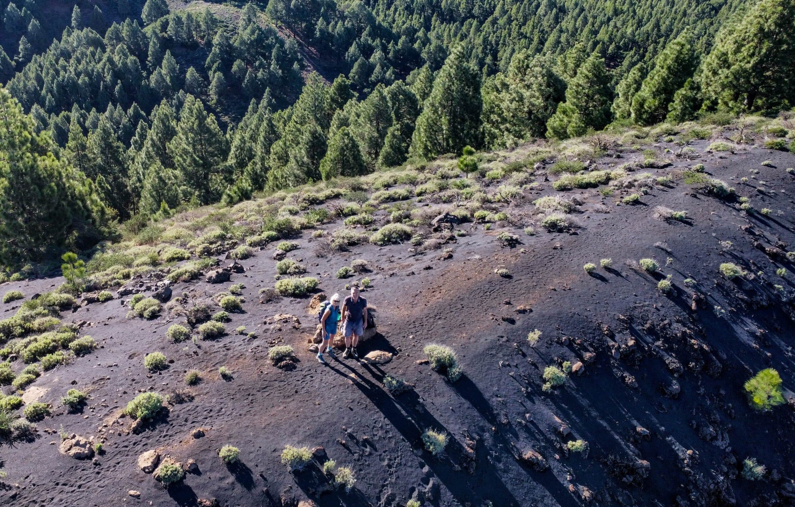
Hikers on the ridge trail over the peaks
And finally
I hope you enjoyed this beautiful loop over four volcanic peaks. The loop can be extended and shortened very well with many other hiking trails in the vicinity of El Pilar. Whichever route you choose, I hope you enjoy all your hikes,
Dagmar from Siebeninseln
Thank you for reading!
If you've found my hiking guides on SiebenInseln helpful for your Canary Islands adventures, please consider leaving a small tip. Your support is greatly appreciated and helps cover the costs of maintaining this blog.