Caldera de Taburiente National Park
The Caldera de Taburiente forms the heart of La Palma, so to speak. Since 1954, the Caldera de Taburiente, the best known and largest erosion crater in the world, has been declared a national park. The caldera measures 9 kilometres in diameter and is surrounded by rock faces up to 2000 metres high, which form a horseshoe-shaped ridge. The open side forms the Barranco de las Angustias. This opens the caldera, the large crater, to the sea.

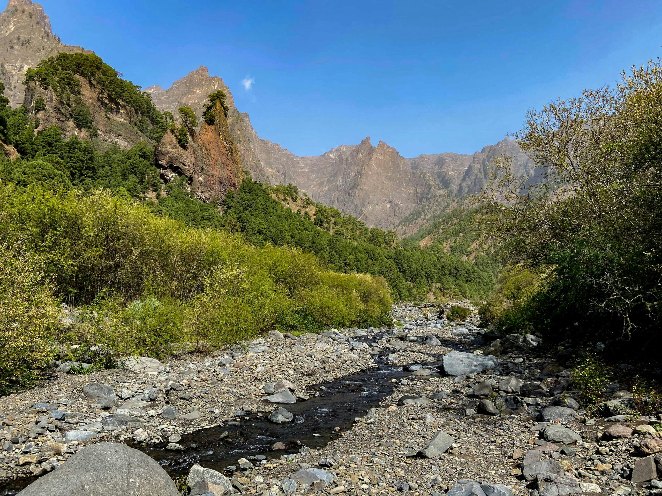
View from the hiking trail near Mirador de los Brecitos
Map
At the edge of the Barranco you will find varied vegetation, streams and waterfalls – a more than impressive nature between the high rock faces. As dogs are strictly forbidden in the national park, I used to walk more on the south side of the island when my Labrador accompanied me on walks. Now my dog Lasko is in well-deserved retirement. And so, during my hiking stay in February 2022 on La Palma, I hiked many trails in the national park for the first time.

Cascada de Colores
Hiking in the Caldera de Taburiente
The Caldera de Taburiente is difficult to access. Even with a car, crossing the huge Barranco Angustias via Tazacorte takes time because of the many kilometres you have to drive down and up again. To enter the Barranco, you can only drive down into the gorge via Los Llanos de Ariadne on a small path. You can only continue on foot. Today I will show you different ways to hike to and through the Caldera de Taburiente.

View into the Barranco de Angustias from the hiking trail
I describe the big circular hike around the Caldera de Taburiente including a visit to the Cascada de Colores waterfall, the Playa de Taburiente and the Mirador Los Brecitos. If the whole hike is too long for you, you can also take a taxi from the car park up to Mirador Los Brecitos and hike down the Caldera de Taburiente from there. You can find all the information and details about the fantastic hikes in the article below.
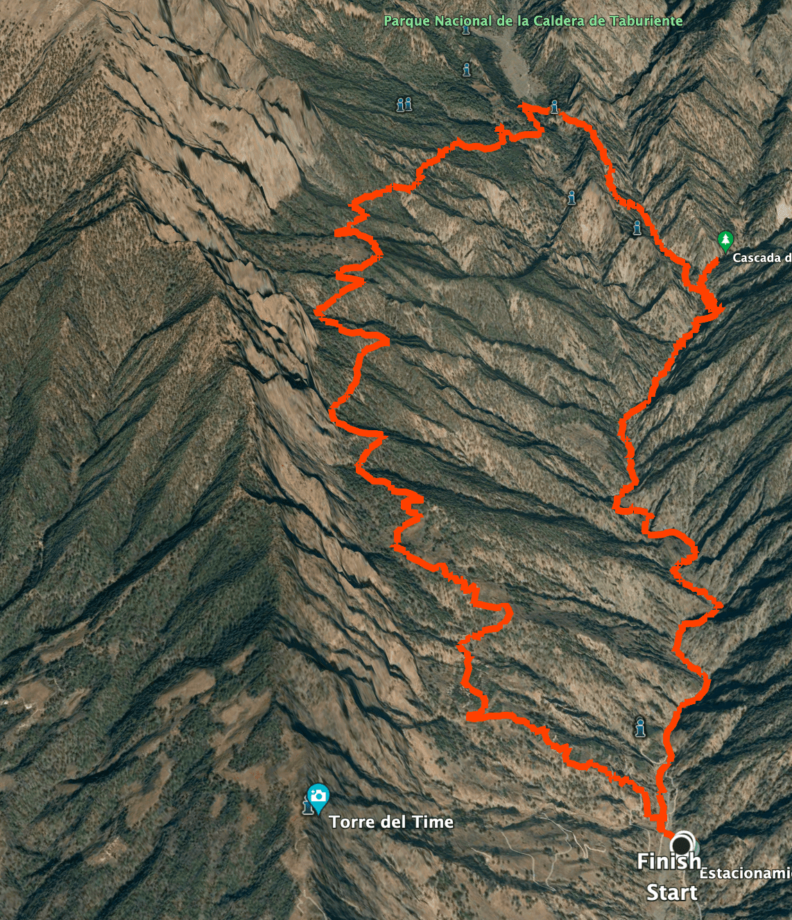
Track of the hike Caldera de Taburiente
General information about the Caldera de Taburiente circular walk
Starting point and approach
The starting point is the small car park in Barranco de los Angustias on Calle la Viña.
GPS Data: 28.685604, -17.909645.
Arrival by car
From Los Llanos de Ariadne, take Calle La Viña down a small serpentine road into the Barranco de las Angustias. At the bottom you will find a spacious car park. This is the permitted terminus. You can also continue up to Mirador Los Brecitos on a road. However, this is prohibited. If you don’t want to or can’t walk the entire 20-kilometre round hike, you can take a taxi from here to the Mirador for €50 (as of March 2022). Often several hikers join together for this purpose and book a taxi together. When you arrive at the car park, you will usually find other walkers with whom you can share a taxi. If you also want to take a taxi back, the last taxi from Mirador de los Brecitos leaves around noon.
Arrival by bus
There are bus connections to Los Llanos de Ariadne. For more information, check the TILP homepage. But then you still have a long way down to the car park. A footpath leads steeply down the barranco, so you don’t have to walk the switchbacks. If you don’t have a car, you should take a taxi, as the trails in the gorge are still long enough. Time
I don’t like to give general times for hiking tours, because the times are very individual. Hiking is supposed to be fun and relaxing. We needed just over 7 hours for the entire long round tour with an extensive break at Playa de Taburiente. However, you can also hike shorter distances (see variants).
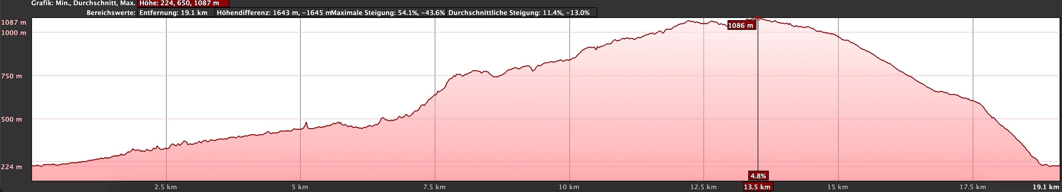
Elevation profile of the hike Caldera de Taburiente
Altitude difference and route length
The difference in altitude for the entire circular hike is approx. 1100 metres. The route is approx. 23.5 kilometres long.
Article summary and large selection of GPS hiking tracks
Sign up for my newsletter now and get exclusive access to my collected GPS tracks as well as all the brief information about my articles.
Sign up nowRequirement
Basically an easy hike (not exposed) on good hiking trails. But if you want to do the whole loop, you need to be in good shape because of the distance and the difference in altitude. Therefore, I classify the tour as difficult overall, but this only refers to the total length of the tour and the altitude difference.
Refreshment
There are no restaurants, bars or shops in the Caldera de Taburiente. Therefore, take enough water and food with you if necessary.
Variants
This tour can also be broken down into individual parts if desired. I describe the entire round tour here. If the long tour with many metres of altitude is too strenuous for you, there are variants. To get a good impression of the diversity of the Caldera de Taburiente, you could divide the hike into two hikes. One day you go into the Barranco de las Angustias and perhaps also visit the Cascada de Colores waterfall. And on another day you might go up to the Mirador de Los Brecitos. This way you will certainly get impressive impressions of the mighty Barranco de las Angustias and the surroundings of the Caldera de Taburiente. Nevertheless, large parts of the Caldera de Taburiente, such as the playa, are not accessible in this way.

Caldera de Taburiente - Start of the hike in Calle de Viña
Many hikers who cannot or do not want to walk the entire round tour therefore also hire a taxi (50 €) at the car park and share the price with other hikers to the Mirador de los Brecitos. This way they can see the part up to the Mirador de los Brecitos from the road and from the taxi. From up there, they can then hike down to Playa de Taburiente and further back through the Barranco de las Angustias. The advantage of this is that you can see the whole round tour. And besides, this tour can be described as easy, as it is almost all downhill from the Mirador de los Brecitos and is also considerably shorter than the big round tour because of the taxi ride.

Hiking path in the Barranco de Angustias
Big round tour through the Caldera de Taburiente
Route section car park in the Caldera de Taburiente to path above the gorge
You start your hike at the car park on Calle la Viña and walk a short distance along the road. After a short while, the hiking trail PR LP-13 (yellow and white) branches off to the right of the road. This will accompany you on the entire hike. Follow the path along the slope. Then you take a road directly into the barranco bed. On my track you can see that I first looked a bit on the left side of the slope and then went through the Barranco bed. As always, there are a few possibilities.

Old bridge in the Barranco de Angustias
But eventually the hike runs for quite a while through the barranco, which is quite wide at this point. Depending on the season, you will also find smaller or larger water rivulets. You walk under a striking old bridge. Then you simply follow the bottom of the barranco for a long time. Finally, the gorge narrows a little. Now you have to pay attention to the signs again. Since you won’t get any further on the bottom, you will first be led up the left side of the slope along the Barranco. On a path above the bottom, you will cross the bottom of the gorge over a wide area.

Slope path above the Barranco Angustias
Route section Path above the gorge to the turn-off to Playa de Taburiente
When you get back to the bottom of the gorge, walk there for a while. Continue to pay close attention to the signs. In the following, the path takes you away from the bottom on the left and then again on the right side of the slope for some time to overcome steps or impassable sections in the Barranco Grund. After about 1.5 hours you will pass a large concrete wall on the left. Soon you will see a dam wall in front of you. Go around it on a small path to the left. Various streams are collected here and channelled into a ring canal.

Hiking along the edge of the Barranco de Angustias with magnificent low views
Shortly afterwards, you will reach the village of Dos Aguas. This is where the two streams (Taburiente stream and Almendro Amargo stream) meet. At this wide point of the gorge you have to cross the Taburiente stream. We succeeded by hopping from stone to stone. At times when there is more water in the streams, you will have to take off your shoes to cross the stream. Afterwards, walk straight ahead in the barranco for a little while. Then the hiking trail branches off to the left up to Playa de Taburiente (signposted as Zona de Acampada).

Turning uphill in the Caldera de Taburiente towards Zona Acampada
Visit to the Cascada de Colores waterfall
If you like, you can visit the Cascada de Colores waterfall before the ascent. Then just stay in the Barranco Grund and follow the signs for about 2 kilometres. First you will pass a waterfall on the left that is fed by the Almendro Amargo stream. Finally, you will reach the Cascada de Colores. This takes its name from the ochre-coloured water, the colour of which is due to the high iron content.

at the Cascada de Colores
I myself found the waterfall rather small, but enjoyed the little excursion very much because of the water and the bright colours. If you take this little detour, you return to the Barranco along the same path. You exit the barranco and find yourself on the hiking trail to Playa de Taburiente, which branches off to the left uphill (signposted Zona de Acampada).
Article summary and large selection of GPS hiking tracks
Sign up for my newsletter now and get exclusive access to my collected GPS tracks as well as all the brief information about my articles.
Sign up now
In the Barranco de Angustias you will come across several waterfalls - here Cascada Río Almendra Amargo
Route section branch to Playa de Taburiente to Zona Acampada (Playa Taburiente)
From now on, you walk up the left slope above the Barranco Río Almendra Amargo, at first at a leisurely pace and then more and more steeply. The ascent takes at least an hour on the well-laid-out hiking trail, which leads you in steep serpentines higher and higher up the mountain slope through the pine forest. This is the most strenuous part of the entire hike. But as the effort increases, so do the beautiful views – not only at the viewpoints such as Somada de El Palo.

View from the ascent path Caldera de Taburiente into the Barranco Río Almendra Amargo
Finally you have made it and reach the ridge, which you cross. Now you have the first magnificent views of the Caldera de Taburiente. On the right ridge, the trail now descends through green bushes, ferns and deciduous trees to the Zona Acampada. The large, shady campsite is the perfect place to take a break. From up here, you can already see Playa de Taburiente with its small stream and rocks below you. In a few minutes you are down there and can also rest here extensively.

Zona de Acampada
Section Playa de Taburiente to Mirador de Los Brecitos
Once you have enjoyed Playa de Taburiente, the trail continues on the other side of the stream. You will immediately enter the pine forest again. The trail is well maintained and well signposted to the Mirador de Los Brecitos. You can’t get lost. It is a long climb, but not as hard as the one from the Barranco up to the Caldera de Taburiente. You cross small gorges again and again on this climb. Every now and then you cross pretty bridges with a beautiful view.

Caldera de Taburiente - Hiking trail over streams - here Playa Taburiente
When I walked the trail in February 2022, the path was partly renewed, so we had to walk a small „hiking diversion“. I also found it interesting that this section of the trail was really more than signposted. Almost every few hundred metres there are signs pointing to Playa Taburiente on one side and the Mirador de Los Brecitos on the other. The indications varied a little. But still, you won’t miss the Mirador de Los Brecitos.

Ascent path from Playa de Taburiente to Mirador Los Brecitos
Section Mirador de Los Brecitos to Large Homestead with Water Reservoir
From the Mirador de Los Brecitos, you first walk a short distance along the road below the mighty Caldera rock face. After about 1.5 kilometres, you leave the road with the PR LP 13 hiking trail to the left. From there it is 5 kilometres to Barranco de Angustias. Of course, you can also just follow the road. However, this would be much longer and in no way as beautiful as the hiking trail. At first, you only cut a few hairpin bends on the road. But then the trail leads you away from the road in a westerly direction.

Hiking trail from the playa up to the Mirador de los Brecitos over many gorges and bridges
You will quickly lose height on the narrow paths and enjoy wonderful views on the descent over the wide valley and the rugged rock faces. Finally, the hiking trail joins a road that leads you downhill past farmsteads. At the end of the road, you reach the road again, which you follow around to the right. But in a bend to the left, the trail branches off from the road again and takes you down over a mountain ridge until you reach a road again at a large farmstead with a water reservoir.

Way back - road and hiking trail 1.5 kilometres behind Mirador Los Brecitos
Route section Großes Gehöft to starting point car park
This time you follow the road downhill only briefly. Then the hiking trail leads off the road to the left, signposted. You walk past fields on small field paths and reach the road again on serpentines. This time you only cross the road and continue along the hiking trail on the other side. Once again you reach the road, which you cross.

Hiking trail at Barranco Angustias up towards Mirador de Los Brecitos (return path here)
The last part of the hike down to the road and the starting point car park is not far. However, this part of the path is quite steep and covered with many small stones, making it a little uncomfortable to walk. But after you have overcome this small uncomfortable stretch of path, you will reach Calle la Viña. Now it is only a few steps around to the right back to the starting point of the car park.

Zona de Acampada - Blick auf die Playa Taburiente und den Bach
And finally
I hope you enjoyed this very long but incredibly varied hike on the beautiful island of La Palma. If you decide to do this loop in the Caldera de Taburiente, you will find many different ways to experience this extraordinary landscape. I hope that I could show you some of them here. I hope you enjoy all your hikes,
Dagmar from Siebeninseln