An adventure hike through the Caldera
Today’s hike through the Caldera is really a small circular hike with some adventure. The S 16 (Sanatorio) and the S 19 (Majúa) below the great Teide are well laid out hiking trails through the Caldera.
Map
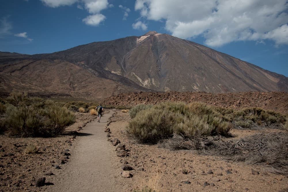
Hiking through the caldera Teide in view
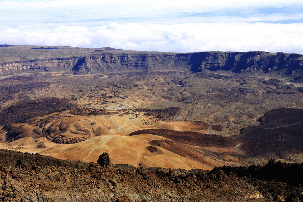
Caldera literally means cauldron. And indeed, this large cauldron was created by the collapse or explosion of a volcanic cone.

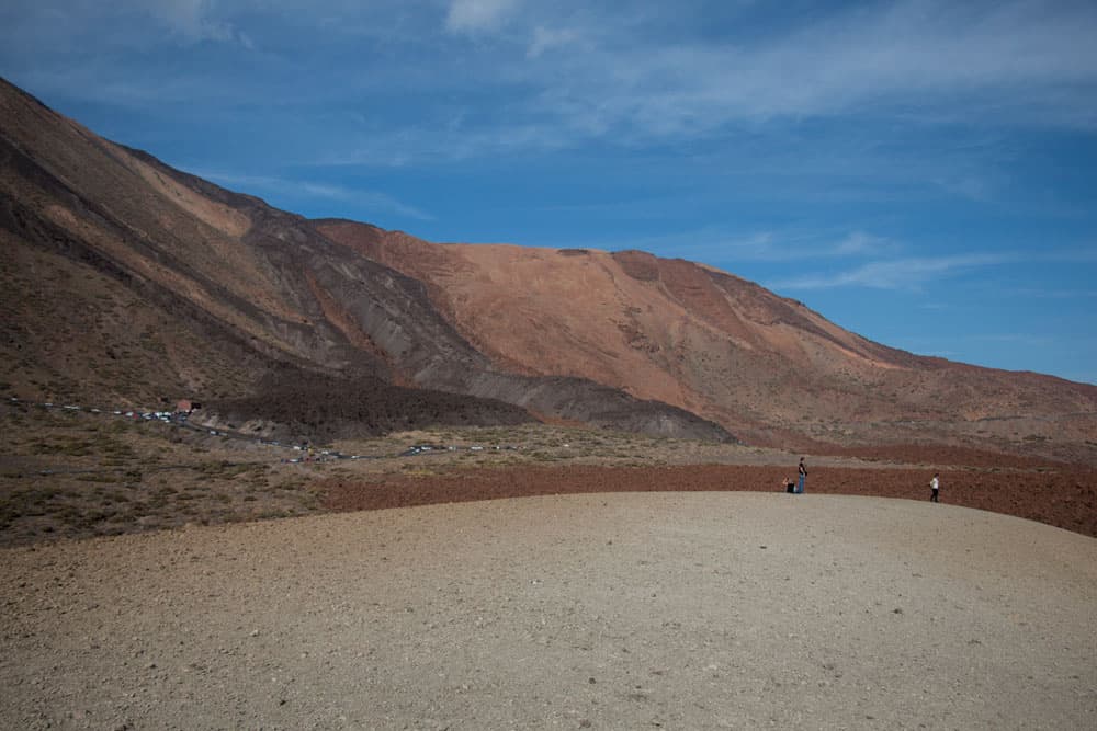
view on the Caldera and the Cañadas
Geologists assume that long before the Teide there was a huge primeval volcano at this place. This is said to have been over 5000 metres high and to have collapsed 170000 years ago. Due to its explosion the caldera and with it new volcanoes were formed. And you wander through the middle of this huge semicircle with a diameter of 17 kilometres.

rock with Obsidian
Dark gem obsidian at the roadside
On this small circular walk in the Caldera there is a lot to discover. First you can see the gem obsidian at close range. Obsidian is a shiny rock glass without crystal structure. It is formed by rapid cooling at the surface of the lava. The stone got its name from the Roman Obsius, who is said to have brought the very first obsidian from Ethiopia to Rome in ancient times.

the gem obsidian
Even if obsidian can appear in many colors, you will only see the black colored obsidian on this way. Worldwide you can find the obsidian at about 70 places. And one of these places is the Caldera at the Teide.

The former ruined houses in front of the Teide - demolition in 2021
Caldera – the place for a sanatorium for respiratory diseases
But not only gemstones are interesting to look at. This circular walk offers even more. The hiking trail S 16 is called Sanatorio. And indeed, until 2021, you passed a small cluster of houses on this path. In this small complex, which was very well hidden behind lava rocks, a sanatorium was to be built in the 1960s. Because the mild climate of the Canary Islands is ideal for the treatment of respiratory diseases.

The former abandoned houses in the caldera, demolished in 2021
And so, in the last century, patients also came to the caldera in search of the healing climate. They built the small houses themselves. About 100 people were supposed to live there. Later, the decision was made to build a sanatorium. Accommodation was built for the doctors and the staff. Then construction stopped, so the sanatorium was never used. But the buildings stood there until they were demolished in 2021.

Hiking path at the foot of the Guajara through the Caldera
Caldera – Hollywood in Teide National Park
And after gemstones and old walls we finally pass striking rocks. This is where the spectacular outdoor shots for the film „Battle of the Titans“ were shot in 2009. Since the impressive landscape in the Caldera offers opportunities for fantastic scenes, numerous videos, commercials and other films have already been shot there.
In addition to the remake of „Battle of the Titans“ with superstar Liam Neeson, the Caldera was also the setting for many scenes from the film „The Planet of the Apes“.

Track to the Canadas circular A 16 and S 19
General information about the caldera circular hike
Starting point and approach
Small car park at TF 21 opposite the cable car station/Teleférico (approx. 39 km). If you can’t find a parking space there, you can use the parking spaces of the cable car nearby.

parking lot - start point
Arrival by car
Article summary and large selection of GPS hiking tracks
Sign up for my newsletter now and get exclusive access to my collected GPS tracks as well as all the brief information about my articles.
Sign up nowIf you come from the south of Tenerife or from the north on the TF-1 motorway, take the Guía de Isora or Chío exits. Then take the TF-38 towards Teide National Park. Or you can choose one of the three other ways to get to Teide National Park. Depending on which direction you are coming from.

hiking map Teide National Parc
Arrival by bus
Twice a day the bus lines 342 (Costa Adeje – El Portillo) and 348 (Puerto de la Cruz – Parador Nacional) run along this route and stop at the starting point if desired. More information you will find on Titsa homepage. Time
I don’t like to give general time information for hiking tours, as the times are very individual. The pure hiking time could be about 3 hours. On the official plan of the Parque Nacional del Teide the S 16 is indicated with 1.45 hours and the S 19 with 1.5 hours. And if you want to take a closer look, it can take a little longer.

Caldera hiking routes signposted
Difference in altitude and distance:

Elevation profile hiking route S 19 (Majúa)

elevation profile hiking route S 16 (Sanatorio)
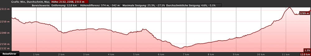
elevatione profile circular walk 16 (Sanatorio) and 19 (Majúa)
The difference in altitude is about 290 meters (with Montaña Matua). The length of the route is about 12 kilometres.
Requirement
An easy tour that can be easily mastered by anyone with a little stamina. The paths are well laid out and well signposted.
Refreshment
In the Parador Nacional there is a restaurant. And if you want to spend the night there, you can find all the information on the homepage. 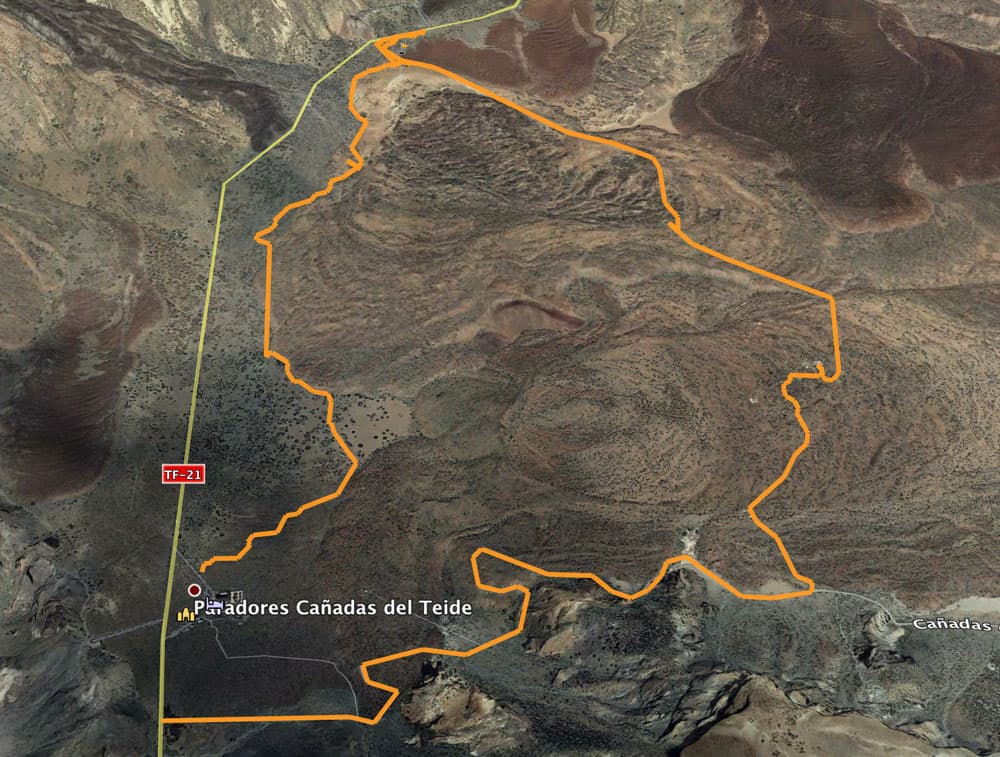
both single tracks: on the right side S 16 and on the left S 19
Variants
This tour can be easily combined with various other hiking and circular walks in the Caldera.
Since the tour is a combination of two hiking trails, the hiking trails S 16 and S 19 can of course also be taken individually.
And if you like, you can also start the whole round tour at the Parador Nacional and hike left or right from there.
I like the start at the small parking lot and the then described way around to the left, as I can take all „sightseeings“ on the Sendero 16 with me during the small descent. The way back Sendero 19 is an ascent path. But from there, there is another small mountain tour to the Montaña Matúa. And up there in the late afternoon the light is particularly beautiful.
Hint

Caldera Sendero 16
During the flowering season, in spring and summer, numerous beehives are set up on this route. These are marked with large information boards. As long as you don’t get too close to them, they don’t pose any danger.
The walk is particularly beautiful in May and June. Then you’ll see the big red shining Tajinasts (endemic plants on the Canary Islands) everywhere in the Teide area.
Directions Sanatorio Majúa Round (S16 and S 19)

Panorama view Caldera with view to Parador Nacional
Article summary and large selection of GPS hiking tracks
Sign up for my newsletter now and get exclusive access to my collected GPS tracks as well as all the brief information about my articles.
Sign up nowParking lot section to Montaña Majúa
You start at the car park opposite the cable car station/ Teleférico. From there, a few small paths lead down over a terrain that is not entirely clear for a short time. However, between bushes and rocks you will quickly find the wide main path with the sign S 16 (Sanatorio). It ends directly at the TF-21, but you can’t park there.
In front of and to the right of it there is a white rock elevation. This is the Montaña Majúa. Paths lead up there to the right of the main path. However, you continue straight ahead, because you will return later (if you like) over the height.

Panoram Cañada Blanco with Teide in the background
Section Montaña Majúa – Sanatorium
On the comfortable hiking trail you go leisurely downhill. If you turn around you will see the mighty Teide and to the right the Montaña Blanca. And it doesn’t take long at all, then you can already see black rock on the left side that shimmers a little. Now you can take a close look at the obsidian described above.

the former ruined houses below the Teide on hiking trail 16
And when you have looked at everything carefully and continue walking, you will soon come to a turn-off on the right-hand side to the former houses of the once planned sanatorium described above. To be precise, there are two branches. Both led to houses. But even without the ruins, this is a good place to take a short break with a view of the Teide.

Hiking on wide serpentines in the direction of Parador
Section Sanatorium to Roques del Capricho
You continue downhill and now see the mighty Guajara (the third highest mountain of the Canary Islands) in front of you. After about one kilometre you come to a well signposted hiking crossroads. Turn left and continue up the Guajara. You turn right on the wide path, which passes impressive rock formations below the Guajara.
First you pass Cañada de la Mareta and later Roques del Capricho. You can see how wind and weather have worked on the rocks. From the path you can also enjoy magnificent views not only of the Teide, but of the entire caldera ahead with the Cañada Blanca and the Roques de García.

Hike below the Guajara
Roques del Capricho – Parador Nacional section
The Roques de Capricho were also the backdrop for the above mentioned movie „Battle of the Titans“. In wide serpentines the gravel road now leads down to the Parador Nacional. You can enjoy further wonderful views. The hike in May is especially beautiful when the Tajinasts conjure up red spots of colour in the landscape everywhere.
On the left a steep path branches off in the direction of Guajara. You keep straight ahead. Shortly before the Parador the S 16 branches off to the right. You go up to the Parador on a narrow footpath in a short time. If you like, you can take a break or take the bus back. 
Hiking path below the Cañadas
Section Parador Nacional – Montaña Majúa
Go past the Parador towards road TF-21. From the access road to the Parador, turn right onto the small road marked S 19 (Majúa). The small road will take you away, but parallel to the TF-21 it will take you back to the car park.
Between broom bushes and Canary Island honeysuckle, the path climbs slowly. To your right is a lava ridge, along which the path leads you upwards. The path follows the course of this long ridge. It goes slowly uphill until you see the Montaña Majúa in front of you.
view from the Montaña Blanca to Teleférico Teide
Montaña Majúa – Parking lot
The actual hiking trail S 19 leads you left past the Montaña Majúa. Follow the foot of the mountain in a wide arc around it and back to the car park. From the S 19 path, however, a wide white path branches off to the right, not to be missed. Straight and steep, it leads you to Montaña Majúa. This small detour is worth it. From up there you can enjoy a fantastic panoramic view at the end of the tour.

Panorama Montaña Matúa
The view reaches over the whole Caldera. If you are there early in the morning or late in the afternoon, the light is especially good for taking pictures. You can also retrace your route from up here. The descent is possible in several directions and leads you either back to the S 16 or S 19. From there it is now only a short way back to the starting point parking lot.

way to the Guajara from the hiking route S 16
And finally
Anyone can do this little circular hike. And if the whole round is still too much for you, you can only go on the S 16 and take the „sights“ with you on the descent. Of course I mean this only figuratively, because in the national park all plants, stones and of course also the precious stones are under special protection. Have fun on this small fine Caldera round wishes you
Dagmar von SiebenInseln