Many trails lead to Chinyero
Today I describe one of the most famous hiking routes on Tenerife, the Circular Chinyero. Not only the actual tour around the volcano, which erupted about 100 years ago and is still „hot“, is varied.

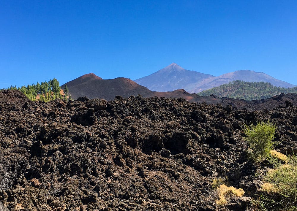
View on the Teide and the nearby volcanos
Especially interesting is the whole area around the black volcanic cone Chinyero. Therefore this hiking route offers something for every taste. Because to the Chinyero and to the round tour many different ways lead from all directions. Some of them can be combined perfectly.

Hiking routes around the Chinyero
Map
The hiking trails to the Chinyero and around the Chinyero are called PR-TF 43, 43.1, 43.2 and 43.3. The longest trail to the Chinyero volcano is the actual hiking trail PR-TF 43, which leads from the coastal town of Garachico to the Chinyero and around it. This trail is 18 kilometres long per route and has a total ascent of 1,680 metres. But don’t worry. Today the actual Chinyero round (Circular Chinyero) is the focus. And this almost seven kilometre long circuit is really feasible for everyone.

Panorama view on the Teno mountains
Chinyero in all variations
Between the big hike PR-TF 43 from Garachico and the small tour around the volcano, there are still many variants and possibilities to adapt the hike individually. And of these I would like to present some of them here today. The volcano is not allowed to be climbed, but to be circumnavigated.

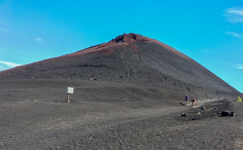
Chinyero - hiking route through the Lava stream
The actual volcano tour is well marked and easy to manage on mostly wide paths – almost a walk for every demand. Those who want to hike even more can climb from the mountain resort Santiago del Teide, from Calvario or from the north of Los Partidos to the Chinyero round. Here you will find some nice variants that will take you to the Chinyero volcano. But first a little to the volcano itself.
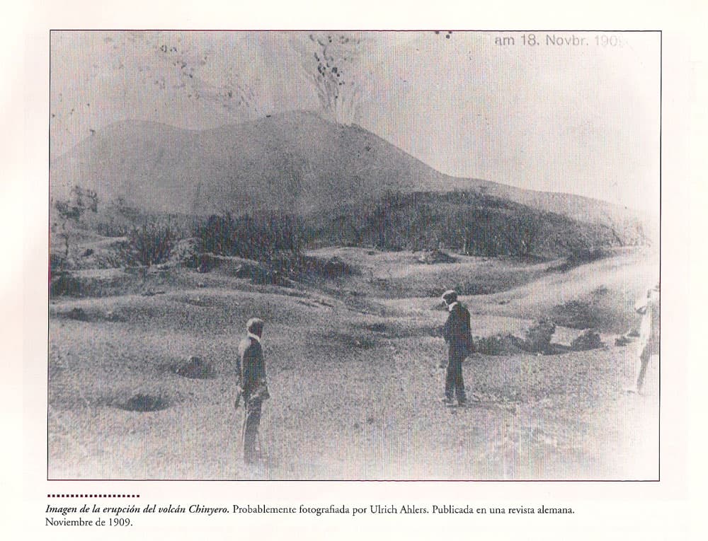
Historic picture from the eruption of Chinyero 1909 - Biblioteca Puerto de Santiago
The eruption of Chinyero
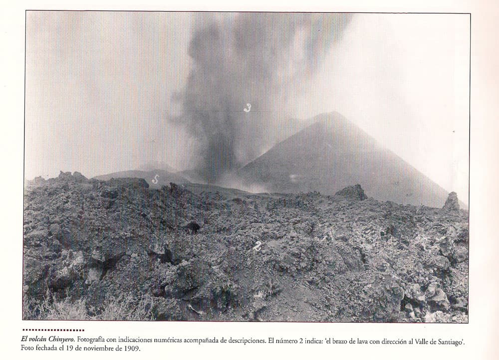
The Chinyero is 1,561 meters high and lies on the western slopes of Tenerife high above the village of Santiago del Teide. It is currently the last volcano to erupt on Tenerife. This happened in November of 1909. For ten days the lava ran out of the volcano Chinyero and already approached the place Santiago del Teide. The ash of the volcano flew far over the cities of the north side and even reached the Anaga mountains.
Fortunately, despite the massive eruption of the Chinyero, there were no major damages or human casualties to mourn. Nevertheless, the eruption had an impact on agriculture. And, of course, people were very frightened at the time. They made processions to the place called Calvario near the village of Las Manchas. There the lava stopped surprisingly. A miracle? Both Las Manchas and Santiago del Teide were saved. As a memento, a small memorial was erected at this place. Every year there is a procession there to commemorate the events of that time.
Historic picture from Ulrich Ahlers from the eruption Chinyero 18.11.1909
Chinyero in the spotlight of the press
In the city library of Puerto de Santiago I found a book with historical pictures. Among them also two photographs of the volcanic eruption. The eruption of the Chinyero is apparently the first volcanic eruption in Spain that has been noticed by the national and international press and has also been photographed.
Since the eruption of Chinyero it is fortunately „volcanic“ quiet on Tenerife. And hopefully this will remain so for a long time to come. But the huge black lava flow from 1909 is an impressive remnant of the events of that time and lets only guess the force of the eruption. The lava flow can be seen on all Chinyero paths. And who climbs from Santiago del Teide, goes sideways with the hiking route along the black rocky sea.

The Chinyero seen from the North side
General information about the circular hike

Hiking Information Board PR TF-43
Starting point and approach
1. who „only“ wants to go the Chinyero lap, starts at kilometer 15 at the TF-38.
2. if you want to hike up from Santiago del Teide to the Chinyero round, you start at the church square of Santiago del Teide.

Roundabout Los Partidos - starting point
And if you want to approach the volcano Chinyero from the north, you start at Los Partidos at the TF-373 at a roundabout (28°19’5.52 „N, 16°47’48.40 „W) just behind the junction of the TF-373 into the TF-82.
Arrival by car
From the TF-1 motorway: exit at Guía de Isora or Chio. Then continue towards Chio and Teide National Park. From Chio take the road up to Teide (TF-38). At kilometer 15 the Chinyero is already excellent. Parking is available.

Hotel Rural in Los Partidos
You can reach Santiago del Teide by car on the TF-436 from the south (Los Gigantes, Tamaimo). You can also take the TF-1 motorway from the south. This ends in Santiago del Teide. Then continue on the TF-436. If you are coming from the north, take the TF-82. There are plenty of parking spaces on the roadside of Santiago del Teide.
By car you reach the roundabout at Los Partidos coming from the south (until Santiago del Teide first like 2.). Then continue through Santiago del Teide towards Icod de los Vinos. After a few kilometres, the TF-373 branches off to the right from the TF-82. After a few kilometres you come to a roundabout. Here at Los Partidos there is a large hiking board and parking facilities along the way.
Arrival by bus
There is no bus connection here. Arrival really only possible by car.
The Titsa bus lines 325 (Puerto de la Cruz-Los Gigantes), 460 (Icod de los Vinos-Costa Adeje), 462 (Guía de Isora-Los Gigantes) and 355 (Buenavista – Santiago del Teide) stop in Santiago del Teide. For more information look on the Titsa homepage. There is no bus connection here. Arrival by car only.

The main hiking route to the Chinyero - hiking map
Article summary and large selection of GPS hiking tracks
Sign up for my newsletter now and get exclusive access to my collected GPS tracks as well as all the brief information about my articles.
Sign up nowTime
I don’t like to give general time information for hiking tours, as the times are very individual. Hiking should bring recreation and make fun. And also I need for each tour sometimes more and sometimes a little less time.

hiking routes to Chinyero
The actual round is a good 2 to 2.5 hours.
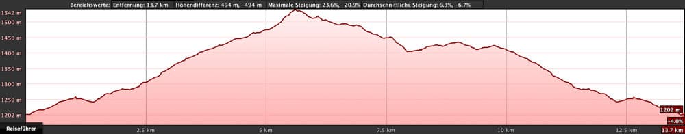
Those who want to hike up from Santiago del Teide and go the round should plan at least 6 hours.
There are several variants of Los Partidos. But who wants to go only up to the Chinyero round and also again back, that should plan approximately 3-4 hours depending upon distance. If you want to do the circuit 1, you should plan at least 6 hours.
Difference in altitude and track length
The difference in altitude is 170 meters. So the actual circular path is 5.7 kilometres long and with the path from the parking lot about 6.6 kilometres. Mountain Chinyero is 1,568 meters high and must not be climbed. At the highest point of the round tour you are at 1,543 meters altitude.
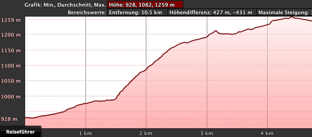
Santiago del Teide lies at 930 meters altitude. If you climb up from there to the highest point of the volcano tour, you will have a net altitude difference of 600 meters. The route is a good 16 kilometres long. However, it can still be shortened by starting the tour at the parking lot over Valle Arriba in Calvario. Officially, however, it is not allowed to drive on this route. Often it is closed since one year in the evening also with a barrier. Therefore I did not list it here as an official variant. If the way should be open, the hiking distance amounts to scarcely 14 kilometres and the height difference shrinks to 350 height metres.
From the north from Los Partidos the shortest distance is 12 kilometres and the longest 16 kilometres. There are between 300 and 400 metres of altitude to overcome.
Here are some height profiles for different variants:
elevation profile Santiago del Teide up to Calvario
elevation profile Calvario-Chinyero
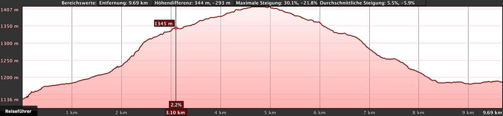
elevation profile Los Partidos and a little circle via San José Los Llanos up to Chinyero circle

Elevation Profile Los Partidos with visiting the top of Montaña de la Cruz
Requirement
The Chinyero round itself is an easy and for everyone with a little physical condition well to master tour on well laid out paths. Also the tours from Santiago del Teide or from the north run generally on well marked wide ways. Here you only need a little more fitness for the ascent.
Refreshment
There are restaurants, bars and shops in Santiago del Teide. Those who start the tour from the north of Los Partidos could stop at the start of the tour or at the end in the restaurant Casa Rural or in a bar in the nearby José de Los Llanos. But on the hiking tours themselves, there is no place to stop for refreshments. Therefore, take enough water and food with you.
Variants
The actual Chinyero round trip can be combined with many tours. I describe here beside the circular path the ascent from Santiago del Teide, from the parking place over Valle Arriba from Calvario and from the north from Los Partidos. But also these tours can be combined and changed in different ways. I have only arranged some possibilities. Maybe you will find another beautiful tour.
And if that’s not enough for you, you can start from the coastal town of Garachico and hike with the PR-TF 43 18 kilometers over 1680 meters of altitude up to Chinyero.
Here are the different tracks:

Chinyero Track combination
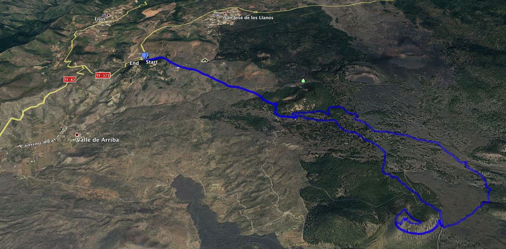
Track Los partidos with Chinyero circular and Montaña de la Cruz

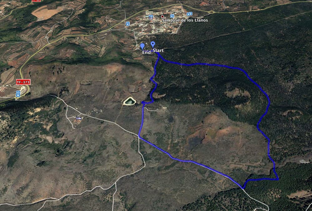
Track Los Partidos and circular Chinyero - back via San José Los Llanos

Track Partidos and circular hike

Track Santiago del Teide - Calvario - Chinyero

little circular hike Los Partidos

Track Calvario along the Chinyero lava stream

Track Los Partidos, Chinyero circular and visit of Montaña de la Cruz
little circle Los Partidos
At high altitudes the weather can change quickly from very sunny and warm to cloudy or even rainy. Therefore always bring a warm jacket or rainwear with you.
Every now and then we hunt in the woods around the Chinyero. Usually Spanish/English texts refer to the hunt.
The volcano itself may not be entered or climbed for nature conservation reasons. But there are other volcanoes and peaks on the tour that can be climbed. Just south of Chinyero is the Montaña de la Cruz. I will describe the excursion there.
Article summary and large selection of GPS hiking tracks
Sign up for my newsletter now and get exclusive access to my collected GPS tracks as well as all the brief information about my articles.
Sign up now
Chinyero circular - the highest point
The Vulta al Chinyero – Tour around the volcano Chinyero
Section parking lot up to the highest point of the hike in front of the Chinyero
You start the circular walk at the TF-38 at the car park kilometre 15. It goes straight through the pine forest. There you keep left and after a short time you will meet a hiking sign called PR-TF 43. This is your route which will accompany you on the whole Chinyero round. Once on the circuit, you can’t get lost. Usually the paths are clearly marked with stone rows.
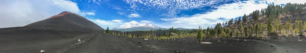
It goes right around uphill through the pine forest. The green Canarian pine, black lava stone and, if you are lucky, a blue sky. A wonderful contrast. From time to time the ascents are a bit steeper. Then it continues almost at ground level again. Right in front of you you see the Teide and the Pico Viejo. On the left the big dark cone of the Chinyero appears slowly. From the highest point of the circular path there are fantastic views of the volcano, which unfortunately must not be climbed.
Volcano Montaña Negra
The highest point of the hike to the parking lot
When you’ve had enough of the beautiful views, the other side of the road goes slightly downhill in a wide arc around the Chinyero. Again and again you have new impressive views of the volcano. At a conspicuous crossroads, where the way from the north meets the volcano round, the way now leads you south past the volcano. You cross the huge black lava flow.
Here the path may be a little bumpy from time to time, but can be passed without problems. When you have passed a big boulder on the other side of the lava flow, you turn left and go uphill again in the pine forest. Now the Chinyero is left in front of you. You have seen it from all sides. You walk until you reach the spot where you left the car park.

View on Teide in snow
Variation: Hike from Santiago del Teide to the Chinyero Circular Trail
Section Santiago del Teide – Calvario
The hike starts at the church square in Santiago del Teide. Follow the path TF PR- 43.3, which will take you past the Santiago del Teide building through a few small streets in the town. Very quickly, the path branches off to the left of the road. It takes you uphill through bushes and almond trees on a narrow straight path. After a short time, the village of Santiago del Teide is behind you. Soon it’s a little steep uphill and shortly after around a water depot. Then the path between stone walls takes you steeply up the mountain.

Chinyero an Pico del Teide
At the moment you are still walking on the famous „almond blossom trail“. So if you do the tour in January, you will see the almond trees blooming around you. It goes towards Teide, which you already see lying ahead of you. You also have beautiful views back to Santiago del Teide and the Teno Mountains. After you have climbed about 300 meters, you reach a larger square. Here at Calvario is the place where the black lava of Chinyero stopped at that time. This can also be seen very well on the track pictures.
Be careful:
A few years ago many cars were parked up here and hikers started the tour from here. The access led on a road over the small place Valle Arriba. Meanwhile the access is forbidden here. The driveway is often closed with a barrier, so that I cannot really recommend this alternative.
Panorama - hikes around the Chinyero
Calvario – Chinyero Circular Route
Leave the square to your left and continue straight ahead on a wider path. After a short while it turns right and you reach the lava flow on a small path, which you cross below Bilma Mountain, which is on your right. After some time the almond blossom trail continues straight ahead. You turn left from the path signposted to Chinyero. Through a small depression it goes downhill for a short time and then uphill again.
From here on you follow the signs to Chinyero straight on uphill. Parallel to the dark black lava flow you climb up the edge of the pine forest. At the point where the volcano roundabout from the crossing of the lava field meets the hiking trail again, you will meet the roundabout. Now you can walk around the volcano Chinyero (right or left) as described above.

Hiker on his way to Chinyero
Trip to a mountain peak – Montaña de la Cruz
Since you are not allowed to climb Chinyero, you can climb a volcano hill south of Chinyero. This is the Montaña de la Cruz. At the junction where the hiking trail from Santiago del Teide meets the Chinyero Circuit, you can follow the circuit to the left. You don’t go over the lava flow, but straight ahead. To your left is the Montaña de la Cruz. And on the left there is also a path that takes you up in very long serpentines that go around the mountain. Up there there is a small hut and because of the wonderful view of the Teide, the Chinyero and the whole region, the summit is very suitable for a small rest.
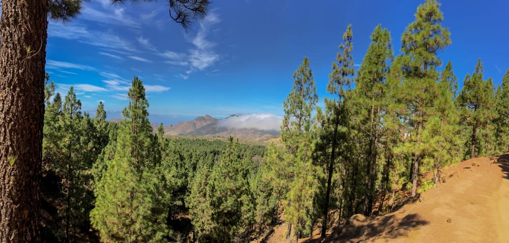
view on the Teno with Pico Verde and Gala
Alternative: Hike from the north from Los Partidos near the village of José de los Llanos.
Section hiking board near Los Partidos – hiking crossroads in the forest
You start the hike at the hiking board in Los Partidos at the roundabout. The not to be overlooked hiking board and a yellow and white marked path will lead you slightly uphill on the wide driveway. After a short time you will leave the hotel and restaurant Casa Rual to your right. After 25 minutes the road becomes steeper and leads into the forest. On small paths that get steeper you go along a Barranco channel on the left side. After about 40 minutes you arrive at a place with a barrier and a water channel. Several paths cross here.

Crossing at the water channel in the woods
Follow the signs and go straight up the mountain towards Chinyero. If you want to enjoy a great view on Santiago del Teide and the Teno mountains, I recommend you to go around the lower road on the left. It leads you along the edge of the mountain and you can enjoy a great view. Then you can go back via the direct way. If you choose the middle path around to the left, you will also come to the Chinyero. This path leads you uphill through the pine forest.

Big rock in the lava field
Section of the trail: Hiking crossroads in the forest – Chinyero circular trail
Whatever you decide here. It goes either directly or in a wide arc up the mountain. You can have a look at the tracks and choose the one that suits you best. I always try new ways and combinations. But no matter how you walk, at some point you will pass a water pipe in the height. From there you have impressive views in all directions and especially to the nearby volcanic cones and the Teide.
And from here it’s 1.3 kilometers to the Chinyero Circuit. You will be guided up and down an easy crossway to a southern point of the circuit. If you still have a lot of energy, you can start the tour now. Otherwise you can immediately decide on another descent route to the starting point of the hike. If you want to hike to Chinyero more often, try all the routes. Each of them is interesting and offers wonderful views. And if you like, you can also make a small detour on the descent and visit the village of San José los Llanos.

view towards the Chinyero
And finally:
I wish you wonderful hiking experiences around the Chinyero. If you would like a more detailed description of a particular tour, feel free to contact me. And if you have found other routes yourself, I would be happy to hear from you.
See you soon,
Dagmar von SiebenInseln