Hike over the south coast to the Roque del Conde
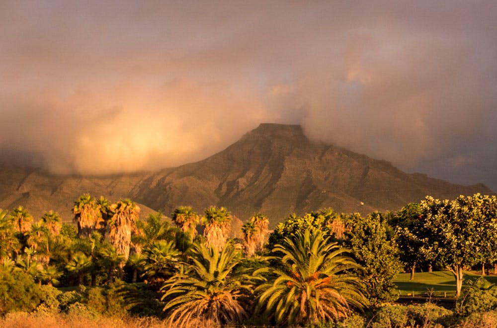
The Conde, with its sloping summit plateau, is a striking mountain in southern Tenerife, visible from afar. Many visitors to the Canary Island of Tenerife, who primarily want to enjoy the sun, look for a holiday home in the south of the island. Because there, sunshine is as good as guaranteed all year round.
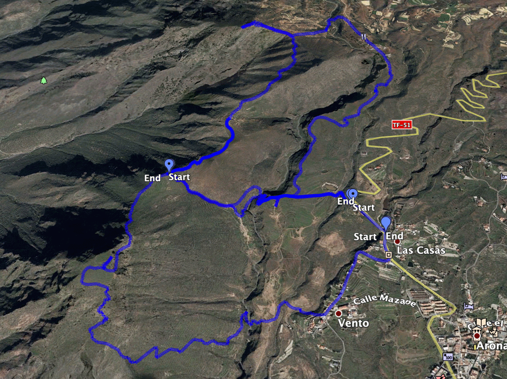
Map

the Conde and in front an abandoned house
But the mountains, the lush vegetation and the forests as well as many popular hiking routes of Tenerife are far away. The south of Tenerife presents itself to the arriving sun hungry in contrast to the wooded and with colorful flora covered north, rather from its barren side.

View from the Conde to the Roque Imoque and the Roque de los Brezos
But also in the south of the island there are some very interesting hiking possibilities. Beside the round tour around the Roque Imoque, the ascent of the Conde is without a doubt one of them. Those who want to get to the Roque del Conde will find it almost in front of their „hotel door“ and will thus save long travel times. Therefore, the hiking tour to the summit of Roque del Conde is popular with locals and tourists alike. 
painting in Arona
Hike from Arona to the Roque del Conde
Starting point for the hike on the Conde is the village of Arona (630m). Arona with its 75.000 inhabitants is together with Adeje the administrative district for the cities in the south, like Playa de Las Américas. Through this administration Arona is a rich city. And this can be seen at first glance in the houses and the local infrastructure.

hiking path over rocks
Before and after the ascent of the Condes, a walk through the narrow alleys of the old town with the many well-preserved or reconstructed houses in the old Canarian style is definitely worthwhile. In the centre of the town, on the large square, visitors can make a short visit to the small church and take a look at the town hall. Those who like can enjoy a coffee or a beer after the walk under the big shady trees.

Rest with a good view
Which route to the Roque del Conde is the right one for me?
In travel and hiking guides, the classic route to the Roque del Conde is described by Arona from the Calle del Vento. This path is well signposted and a good hiking trail. Those who use it cannot do anything wrong. But then you go on the same way to the Conde, where you also return. Today I would like to introduce you to another route besides the classic hiking route. In this way you can climb the Conde combined with an interesting circular hike.
The classic ascent path is the way back. The way there goes over the Degollada de los Frailitos and over the front steep rock face of the Conde. However, this trail is really only recommended if you are completely free of vertigo and sure-footed. The path is very steep, partly very impassable and in some places exposed. Personally I don’t want to go downhill very much. But if you feel safe enough, this round tour on the Conde combined with an airy cross passage at the front rock face is a real experience.

Track circular hike from Arona over the summit of the Conde

Track Hike from Arona to the Conde and back
General information about the hike on the Roque del Conde
Starting point and approach
The starting point for the circular walk is the small car park on the left-hand side of TF-51 (Calle Las Casas), which leads from Arona to Vilaflor. This signposted car park is right in front of the restaurant La Granja de Arona. It is a 10 minute walk from Arona (about 1.5 km).

Hiking board and start of the Conde hiking path
The classic Conde tour without the Degollada de los Frailitos starts on the village street Calle Vento in the district Vento of Arona (630m) at house no. 78. This is also the place where you come back to Arona on the round tour.
Arrival by car
From the TF-1 motorway to the south, take the Arona exit and follow the TF-28 towards Arona. In La Camella turn left onto the TF-51 towards Arona. There are a few parking spaces in front of the hiking sign at the starting point or a little down the road in the direction of the Arona exit sign below a small chapel. If you like, you can also park in Arona and walk to the starting point in 10 minutes.

parking in Arona - starting point
Article summary and large selection of GPS hiking tracks
Sign up for my newsletter now and get exclusive access to my collected GPS tracks as well as all the brief information about my articles.
Sign up nowFor the classic Conde tour, you can take the car to the starting point in the Vento district.
Arrival by bus

signpost Roque del Conde
From Los Christianos there are several bus connections to Arona. The lines 342, 480 and 482 stop in the village. You can find detailed information and further connections on the Titsa homepage. Time
I don’t like to give general time information for hiking tours, because the times are very individual. Pure hiking time for the ascent of the Roque del Conde approx. 1.5 hours. For the round tour with extensive summit rest we needed 3 hours.

elevation profile Conde hike - Arona and back
Difference in altitude and distance
It is 370 meters of altitude from Arona (630m) to the top of Conde (1001m). But for the hike with crossing of the three Barrancos you need about 500 meters of altitude gross. The distance is altogether approx. 5.5 kilometers long.

elevation profile hike Arona to the ridge ascent Conde

elevation profile ascent Conde
Requirement
The hiking trails on the Conde are very well marked. If you take the path from Vento to the Conde and back, the tour is easy. In the beginning you have to master three „small“ Barrancos with their ascents and descents. Afterwards the ascent of Roque del Conde is a wonderful mountain walk. If, on the other hand, you choose the circular hike and climb up the Degollada de los Frailitos, then it’s a steep climb. The path at the front rock face of the Conde is partially exposed. And therefore absolute freedom from vertigo and sure-footedness are a prerequisite.

Ascent summit - exit
Refreshment
There are restaurants, bars and shops only in Arona at the starting point. Therefore take enough water and food with you.
Track Conde and track around Roque Imoque
Variants
This tour can be combined well with various other hiking and circular walks in the vicinity. Worth mentioning here is for example the round tour around the Roque Imoque with the ascent of the Roque de los Brezos. For the very ambitious: How about a 3 summit tour (Conde, Roque los Brezos and Roque Imoque)? 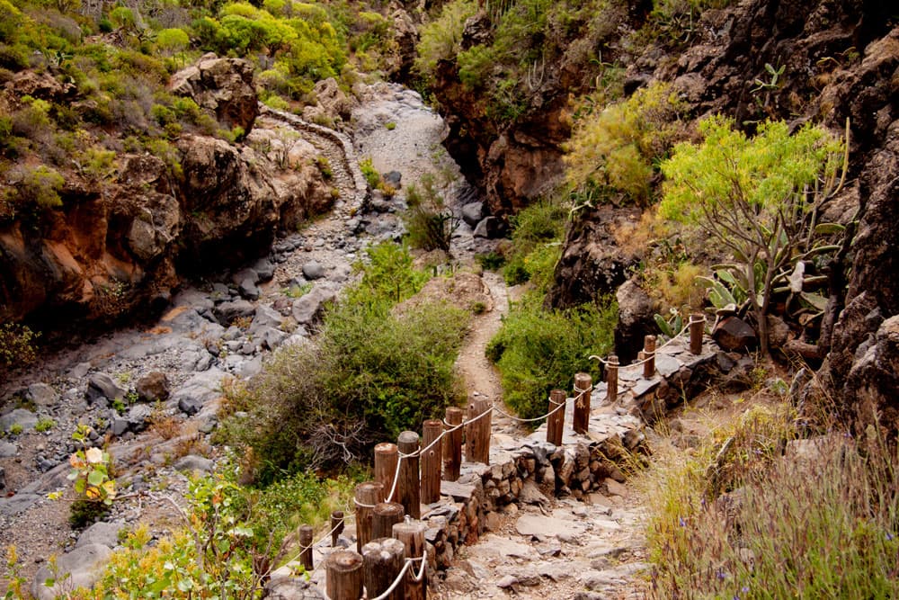
hiking path Barranco del Rey
Hikes on the Roque del Conde
Classic tour to the Roque del Conde
Arona section, Calle Vento n. 78 to Barranco del Rey
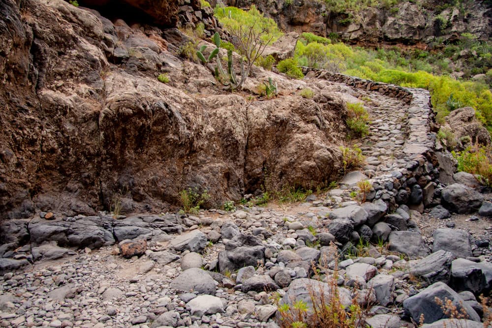
For the hike on the local mountain of Arona, the Conde, you start in the district Vento. If you arrive by car, you will already be guided inside Arona by large signs pointing to the Roque del Conde. From the village road, turn right between the houses in a westerly direction along the path towards Roque del Conde. The path is marked white-red-green and well marked. Before the actual ascent to Roque del Conde begins, you first cross two small and one larger Barranco (Barranco del Rey).
hiking path through Barrancodel Rey
First it goes through the Barranco de las Casas and then through the very small Barranco del Ancón. After the crossing you will find signposts and the path divides. You stay on the green-white marked path to the left at the Barranco edge and after a short time you reach the Barranco del Rey. There it goes on a narrow staircase with steps steeply down into the depth. You descend into the narrow ravine on the well-developed path. In the Barrancobett the path continues to the right and leads you uphill again on the opposite side of the Barranco.
Article summary and large selection of GPS hiking tracks
Sign up for my newsletter now and get exclusive access to my collected GPS tracks as well as all the brief information about my articles.
Sign up now
Threshing circle close to the hiking path
Barranco del Rey to the top of Conde
When you get to the other side, turn left. From now on the path will lead you steadily uphill. You pass a ruined house and an old threshing floor. And finally you walk across wild terrace fields further uphill. After about three quarters of an hour you reach the ridge (Centinela). Now you have already climbed 776 metres. From this vantage point you can enjoy a first view over the Atlantic Ocean to La Gomera and the south coast with the large holiday settlements. Los Christianos and Playa de Las Américas lie far below you like a place with many small toy houses and streets.

view from Conde to Los Christianos
You continue to climb the path on the slope in small and large serpentines. Before you reach the striking high plateau of Roque del Conde, you have to climb the steep path over some rocks. The entry point to the plateau should be remembered for the way back. Then you can cross the wide plateau up to the surveying column and enjoy beautiful views in all directions – perhaps at a picnic.

view to the Roque Imoque
Circular hike to the Roque del Conde
Arona car park section to Barranco del Rey
The starting point for the interesting circular hike around the Roque del Conde is the hiking car park described above with hiking signs. You follow the small road in front of the restaurant La Granja. After a short time the Camino del Topo branches off to the right, while you follow the Camino Suárez straight ahead. On this circuit there are no numbers at the signs, only the green and white signs. On the left side you soon pass a ruin (Casa El Ancón). Here you can visit an old stone oven. In front of you lies the mighty Conde. You walk around the ruin and stand shortly after at the edge of the Barranco del Rey.

hikers in the Barranco
A small path leads you steeply in some bends down to the Barranco Grund. When you have reached Barranco Grund, you can turn right. After a few meters, you will come to the right side of the Barranco again, where you have to climb steeply in short serpentines. This point is a bit difficult to find as the green and white markings are washed out. The last time I was there in April 2018, this path was partially covered by a landslide (the JPS track for this path can be found under Tenerife Hike Roque Imoque). But with a little clambering you can get around the places in question. Alternatively (and so in this track to the Conde) you can also walk around the Barranco Grund to the left. After a short time the ascent from Barranco is on the right side.
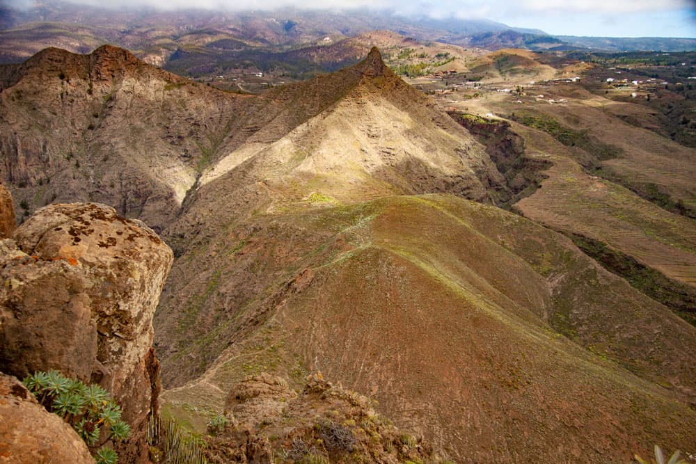
View from the summit of Conde to Roque Imoque and Roque de los Brezos
Section Barranco del Rey to Quergang Conde
Whichever way you choose out of Barranco del Rey. On the other side of the Barranco del Rey you keep straight on the way towards Conde. After a short time, the path joins the GR 131, which is marked in white and red. Follow the path uphill to the right. After about 15 minutes you reach the Degollada de los Frailitos at a height of 758 metres. Here on the saddle before the Conde you have a wonderful view of the south coast and in the other direction of the Roque Imoque and the Roque de los Brezos.

view at the ascent Roque del Conde
Note: I shared the JPS tracks for the round trip because I first climbed further to the right (take Conde 1 to here and then change to the JPS track Conde 2).
While the tour around Roque Imoque continues on the right, you keep left. You go directly on the small path over the ridge towards the Conde. The path becomes narrower and steeper after you leave the ridge and immediately below the rock massif of the Conde. You have to climb over some boulders. Finally you reach an airy cross passage, which takes you further up the rock massif on a very narrow path. This path, which also leads over rocks, is marked only with green dots.

path at the sloop of Conde
Cross-country Conde section to the summit
You’ll reach a small rocky plateau, which you’ll cross. Then you continue up around the front rock face of the Conde. The views of Arona and the surrounding landscape are fantastic. But you have to concentrate on the steep climb where the steps should be set. After you have walked around the entire rock massif in the ascent, you reach the large summit plateau of the Conde through a small exit. The plateau lies in front of you like a large flattened oversized football field.

view from the summit to the ridge
Formerly there were terraced fields up here. Remnants of this cultivation can still be seen everywhere, but in most places they are overgrown with wild bushes. In just a few minutes you have crossed the high plateau to the highest point, a survey column. From here, at 1001 metres above sea level, you can not only enjoy the view of the entire south coast that lies stretched out in front of you. You look at the Barrancos of the south and towards the centre of the island at the Roque Imoque and the slopes of the Teide. The hectic hustle and bustle in the tourist island metropolises can only be guessed from up here. Time for a rest at the summit.

View to Los Christianos and Las Americas from the summit of Conde
Back to Arona you go on the classic Conde Tour described above. When you arrive at the bottom of Calle de Vento, turn left into the road and follow it uphill. After a while, this road meets the main road from Arona to Vilaflor, where you started the hike.

hiking path from the ridge to the summit of Conde
And finally
I hope you enjoyed the walks on the Conde. Just choose the one that is right for you. And then I wish you a lot of fun while hiking,
Dagmar von SiebenInseln