The Guergues Steig has been open to hikers again since January 2026.
Tenerife: Guergues trail one of the most popular hikes
The Guergues Steig is the mountain ridge between the Barranco of Masca and the Barranco Natero. There the rock massif runs from the height of the Teno Mountains in a westerly direction towards the Atlantic Ocean. The entire mountain ridge can be walked on a footpath.
Map

View from the Guergues Steig to Mount Teide
Farmhouses, the Casas de Araza, are close to the starting point of the hike. From there the goats are often driven on the Guergues path, so that you can suddenly stand in the middle of goats on your hike.

Panorama Guergues Steig
The hike over the Guergues Steig leads you first up and down, but still keeping height, right and left along the mountain ridge. You can enjoy fantastic views over the south coast, over the Atlantic Ocean and the neighbouring islands La Gomera and La Palma, to the Teide and into the gorges of Masca and Natero. Finally, you can climb a small peak over the Lomo de Tablado (a meadow plateau) with 1,023 meters of altitude. This is the highest point of the hike.

Panorama view to La Gomera and south coast
Then it goes down past ruin houses to a threshing floor. From there the narrow path leads you downhill past an abandoned finca to the finca Guergues, which gave its name to the Guergues Steig. If you want to go on, it will be adventurous, because you won’t find the right paths anymore. You can make your way to the edge of the Barranco de Masca. Alternatively, you can continue high above the Barranco de Natero towards the Atlantic Ocean and enjoy a wonderful view from a small rocky height.

track Guergues Steig with extensions
General information on the Guergues Steig circular hike
Starting point and approach
Parking Mirador Masca or way to the Casas de Arazas at 980 meters altitude on the road TF-436 between Santiago del Teide and Masca. The Mirador Masca is located about 400 metres below the Cherfé Pass.
Arrival by car

Starting point Masca with Casas de Araza
Coming from the north via the TF-436 towards Buenavista del Norte. From the south and the centre of the island you pass through Santiago del Teide and then over the TF-436 and the Cherfé Pass. Parking is available at the Mirador Masca (from there about 200 metres to the junction of the footpath). However, even on this once relatively empty parking lot it is getting fuller and fuller in the last years. Often there is a dealer with his car and sells fruit and fruits. And also the big tourist buses stop so that the tourists can enjoy the view over Masca.
Arrival by bus
There is a bus connection between Buenavista del Norte and Santigo del Teide (Titsa line 355). The buses stop in Masca and also at the starting point, the Mirador Masca. From Buenavista del Norte there is also a bus line 365 to Masca. If you take this, however, you must walk up the road from Masca to the starting point of the hike or take a taxi. Further details and connecting buses can be found on the Titsa homepage. Time
I don’t like to give general time information for hiking tours, because the times are very individual. For the hike to the Finca Guergues and back I calculate about four hours. If you continue from there, the hike will be longer.

elevation profile Guergues Steig
Difference in altitude and distance
The height difference of the hike over the Guergues Steig is about 540 meters. The route is a little over 6 kilometres long.

elevation profile hike Guergues Steig from the plateau to the threshing circle
Article summary and large selection of GPS hiking tracks
Sign up for my newsletter now and get exclusive access to my collected GPS tracks as well as all the brief information about my articles.
Sign up nowRequirement

path Guergues Steig
The hike over the Guergues Steig often leads on narrow paths directly along the abyss. Therefore, you should be free from vertigo and sure-footed. Those who want to go out from the Finca Guergues even further on the plateau will find wild and overgrown paths.

rock - Guergues Steig
Refreshment
Restaurants, bars and shops are only Masca and Santiago del Teide. From time to time, a car that sells fruit and fruit stops at the car park at the starting point. Therefore, be sure to take enough water and food with you.
Variants
This tour can be arranged in different lengths. Many hikers only walk the Guergues Steig up to the threshing floor. Until then it goes up and down. But basically the height of the starting point is maintained. There is also a good view from Dreschplatz. From there it goes down to the Finca Guergues more than 200 height meters on narrow paths (not at the abyss), which of course have to be climbed up again.
And for those who don’t have enough, it goes even further out to the plateau. Towards the north you can visit the edge of the Barranco de Masca. And on the south side there is a protruding rock with a fantastic view into the Barranco Natero.
Reference to dogs
On the hiking trail you will come through a goat grid, which has to be opened and closed. The farmer has been putting up a sign there for some time that dogs are not allowed to pass through the grate. I myself have experienced that the farmer intervenes right at the starting point as soon as you try to bring a dog with you on the Guergues trail. I cannot say whether he is entitled to do so on a public trail. But if you should have a dog with you, leash him because of the free running goats in any case.

my labrador on the top of the Steig
Hike over the Guergues Trail
Section Mirador Masca to the paved hiking trail

View to the sea
You start the hike at Mirador Masca and go down the road to the right for about 200 meters until you reach the first sharp right turn. From there you can see some houses on the left hand side of the Barranco. These are the Casas de Araza. A road leads down the hill to the houses. But you take the small path to the right at a blue ton, which – like the whole hiking route – is very well marked by stone figures. It is almost impossible to walk along this ridge, as the path is always quite close to the ridge on the left and then again on the right side of the slope.

Casas de Arazo - Starting point of the hike

view from the Guergues Steig to Masca
The first 20 minutes of this hike, however, will take you through light scrub and bushes. You can see from the well-trodden sandy paths that many goats usually walk along here as well as a few hikers. The small goat paths lead you to the right and left around larger groups of shrubs. At the beginning of the hike there are several options to choose from to get close to the entrance to the Guergues Trail. The only important thing is not to go too far to the left and thus into the valley on the way to Barrancos Natero. Until the beginning of the paved path, the path runs along the left side of the slope.

rocks at the Guergues Steig
Section of paved hiking trail to the summit
From now on the path can be seen very well after the first overgrown section. It is partly paved with large boulders, well marked and runs mostly on the left side of the slope. From time to time there are fantastic views also to the right side to Masca and into the Barranco of Masca. You pass a striking rock that stretches up like a finger. Behind you, with clouds in the sky, you can see the Teno Mountains and the mighty elevation of the Teide. In front of you lies the neighbouring island of Gomera and, with clear visibility, La Palma can also be seen further north.

View on the central Teno Mountains with the road to Masca
After walking for half an hour – partly over rocks – you will reach a gate. There a hand-painted sign indicates that dogs are not welcome. After about a quarter of an hour you will arrive at the other end of the gate. From there you follow a very small steep path in narrow serpentines back up to the ridge. When you reach the top, change the side of the slope. The path now continues along narrow, partly narrow and exposed paths on the right side of the slope. The view into the Masca Gorge is great.
Article summary and large selection of GPS hiking tracks
Sign up for my newsletter now and get exclusive access to my collected GPS tracks as well as all the brief information about my articles.
Sign up now
Panorama Guergues Steig with La Gomera
After a short time you climb up again. You cross an exposed rock plateau and walk around a rock nose. Then you go straight on for quite a while and continue at the same height under rocks on the left side of the slope. Shortly the path changes again to the right slope side and then goes back to the left slope side. From here you can now walk right up to the summit and highest point of the Guergues Steig with 1,023 meters.

rock formation
Stretches from the summit to Threshing Circle
From the summit you can enjoy a wonderful view in all directions. Here is also a good opportunity for a sheltered picnic on the rock face. At this point you have gained 22 meters in height opposite the starting point, despite constant ups and downs. Up there on the Guergues Steig I experienced sunny, but also some rainy and foggy days. On these days I walked through cool wet clouds. A view was hard to imagine. But with a cloudless sky the view over the whole south of the island and the Atlantic with the neighbouring islands is simply gigantic.

Gates with a reference to goats - dogs banned
To the southwest we descend from the summit over the Lomo de Tablada, a meadow plateau. At the lower end of the green area covered with bushes, you will find ruins of houses and an old threshing floor. You can get there in loose serpentines through green bushes. It goes quite effortlessly downhill on this green meadow. The old threshing place, which shows that agriculture was once practised here, offers a good view and an opportunity for a rest. For many hikers, the end of the tour over the Guergues Steig has been reached after about 1.5 hours.

meadow on the Guergues Steig
Section Dreschplatz to Finca Guergues
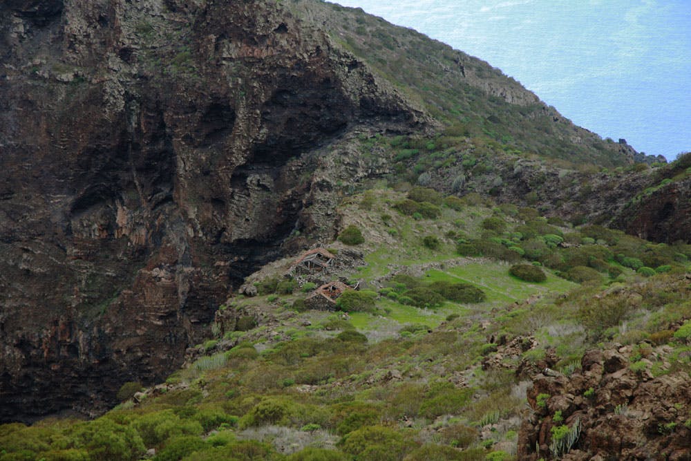
From Dreschplatz a narrow path leads quite steeply and steadily downhill. Some hikers, knowing that they have to come back and up again, shy away from the further descent at this point. But if you have enough time and fitness, you shouldn’t be afraid to descend a little further. The stony narrow serpentines are partly covered with bushes. After a quarter of an hour you will pass another ruin. And after another quarter of an hour you will stand at an altitude of about 750 metres. Your are in front of two detached house ruins. This farm is the Finca de Guergues.

ruin house on the descent to Finca Guergues
The Finca is deserted but very picturesque on the left side of the ridge. On the right side of the finca there is another very large green meadow covered with bushes. At this point the ridge is so wide that if you look to the right you will not feel as if you are high on the ridge. Many possibilities for a rest, good views and the official end of the hiking route Guergues Steig awaits you at this point.

Finca Guergues
Section of Finca Guergues along the edge to Barranco Natero
If you don’t have enough and want to go further, there are several alternatives to choose from. From the Finca de Guergues there is no clear hiking trail. For example, you can follow a suggested path at the left edge of the Finca Guergues further west. On it, you go quite close to the steeply dropping rocks high above the Barranco Natero. After some time you will reach a small rock massif where you can hike up, climb and climb. But extreme caution is required, as it goes steeply downhill in all directions and the path more or less only consists of a very steep climbing path.

rocks on Guergues Steig
Once you reach the small summit, the view is once again so beautiful. The large green area of the plateau is at your feet. And on the other side you descend steeply into the Barranco Natero. When you have climbed down from the massif again, you can look for a path through bushes. This leads a little further along the left side of the slope and towards the edge of the abyss towards the Atlantic Ocean. When I went this way (only 1x) I unfortunately had no GPS with me, so there is no track.

view from the break-off edge into the Barranco of Masca
Section Finca Guergues to the northern edge Barranco de Masca
The second possibility from Finca Guergues is a path that descends slightly to the north across meadows and bushes to the other side of the plateau. It is no longer marked with stone figures, but at first it is easily recognizable as a beaten path. After about 20 minutes of walking from Finca Guergues, you will stand on the other side of the edge and look down onto the Masca Gorge again. If you still don’t have enough here and dare to go a little further, you can scramble on the narrow path and the rock in front and enjoy breathtaking views down into the Masca Gorge.

Finca Guergues
And finally

goats on the rocks
If you are a regular hiker in Tenerife, you will be familiar with the popular hike along the Guergues Steig. Maybe you’ve walked from the Finca Guergues to the edge of the abort. I would be happy if you would share your experience here with all hikers. I wish you a lot of fun on this beautiful mountain route over the gorges,
Dagmar von SiebenInseln