Montaña Pelada is a volcano on the coast of Tenerife with an impressive crater of approximately 2,500 meters in circumference, formed many years ago through an underwater eruption. It is located near the particularly popular coastal town of El Médano, meaning „sand dune“ in Spanish, and is a district of the municipality of Granadilla de Abona. El Médano is home to around 8,500 residents, and due to its constant winds, it attracts many water sports enthusiasts, especially wind and kitesurfers.
Map
I’ll describe a short hike with various options around Montaña Pelada. If you wish, you can take a full circuit around the entire crater. For those looking for a longer hike, combining a visit to Montaña Pelada with a coastal walk from El Médano is also a great option. If you appreciate beach life, you can, of course, circle the mountain and then relax on the beach afterward.
Blick vom Klippenweg über dem Strand auf die Felsenformationen
Many Paths Lead to and Around Montaña Pelada
There is an official path leading to the volcano within the nature reserve, which I will describe here. However, several paths and small trails have formed around the crater over time, used by many people. I’ll describe various options here. Once at the top, you’ll have a splendid view from the crater rim, allowing you to circumnavigate the entire volcano and/or hike straight through the crater.
Beach at the Montaña Pelada
The interesting rock formations, visible from the beach in various hues, are absolutely worth seeing. You’ll witness bizarre volcanic formations created by the interaction of lava and water, making Montaña Pelada a unique natural monument. Even though this is just a short hike, a visit to Montaña Pelada is always worth the excursion.
Track of the Montaña Pelada hike with ascent from the front and descent on the hiking trail (red)
General Information about the Montaña Pelada Hike
Starting Point and Directions
You begin your hike to Montaña Pelada at a small parking lot on Avenida Juan Carlos I in the neighborhood of Arenas del Mar in El Médano.
Arrival by car
To reach Montaña Pelada, take the TF-1 and exit at San Isidro onto TF-64 towards El Médano. In El Médano, turn left at the first opportunity and drive towards La Jaquita along Avenida Juan Carlos I. At the end of the road, you’ll find a small parking lot along with numerous roadside parking options.
Alternatively, you can take the Granadilla Industrial Estate-Acceso B exit and head towards ITER (Instituto Tecnológico de Energías Renovables) to reach Montaña Pelada. However, the unpaved roads in that area are in poor condition, so it’s advisable to drive there only with an off-road vehicle.
You can also park in El Médano and walk to Montaña Pelada.
Arrival by bus
Article summary and large selection of GPS hiking tracks
Sign up for my newsletter now and get exclusive access to my collected GPS tracks as well as all the brief information about my articles.
Titsa Bus lines 411 and 470 stop directly at the parking lot mentioned above. For further information, visit the Titsa website.
Time
I prefer not to give time estimates as they are highly individual. This is evident in the case of Montaña Pelada. The first time I did this short hike alone, it took me 1.5 hours with some detours. Another time, with a group taking their time, we spent over 3 hours on the circuit.
Elevation profile of the Montaña Pelada hike with ascent and descent through the barranco
Elevation Change and Distance
The hike is between 5-6 kilometers long. If you start from El Médano, it’s approximately 10 kilometers in total. The elevation gain is about 200 meters in all variants.
Elevation profile of the Montaña Pelada hike with ascent from the front and descent on the hiking trail
Requirements
It’s an easy hike on well-maintained trails that almost anyone can do. However, if you choose not to take the official ascent or descent route, as described here, a bit of sure-footedness would be advantageous. The paths along the beach above the volcano or from the height down to the beach also require a head for heights and sure-footedness.
Refreshments
There are no refreshment options on the short hike to Montaña Pelada. After the hike, if needed, you can visit one of the many restaurants or bars in El Médano.
Information board for the Montaña Pelada hiking trail with hiking trail and crossing of the crater
Variants
You can circle Montaña Pelada in various ways, which I will present here. If you want to extend the hike a bit, you can also start from El Médano.
Ascent path to Montaña Pelada from the front
Circuit around Montaña Pelada
Route Section from the small parking lot to the Crater Rim of Montaña Pelada
You start your short circuit hike at the parking lot at the end of Avenida Juan Carlos I. As you can see in my variant image, you can walk down to the beach to the right from here and explore the coastal side of the volcano. You can do this as you please before and after the hike. If you want to ascend Montaña Pelada directly, head straight towards it on a narrow path. This path takes you down a small ravine and up the other side.
Steep ascent path at the front
Article summary and large selection of GPS hiking tracks
Sign up for my newsletter now and get exclusive access to my collected GPS tracks as well as all the brief information about my articles.
Don’t be confused by my track (red). We briefly walked along the back rock wall to take a look at the back and the hidden beaches. But then, we ascended steeply on the front side. If the path seems too steep, you should keep to the left around Montaña Pelada on a path at the foot of the volcano. Eventually, you’ll find the comfortable ascent path there, which I described here as the return route.
View over the crater of Montaña Pelada
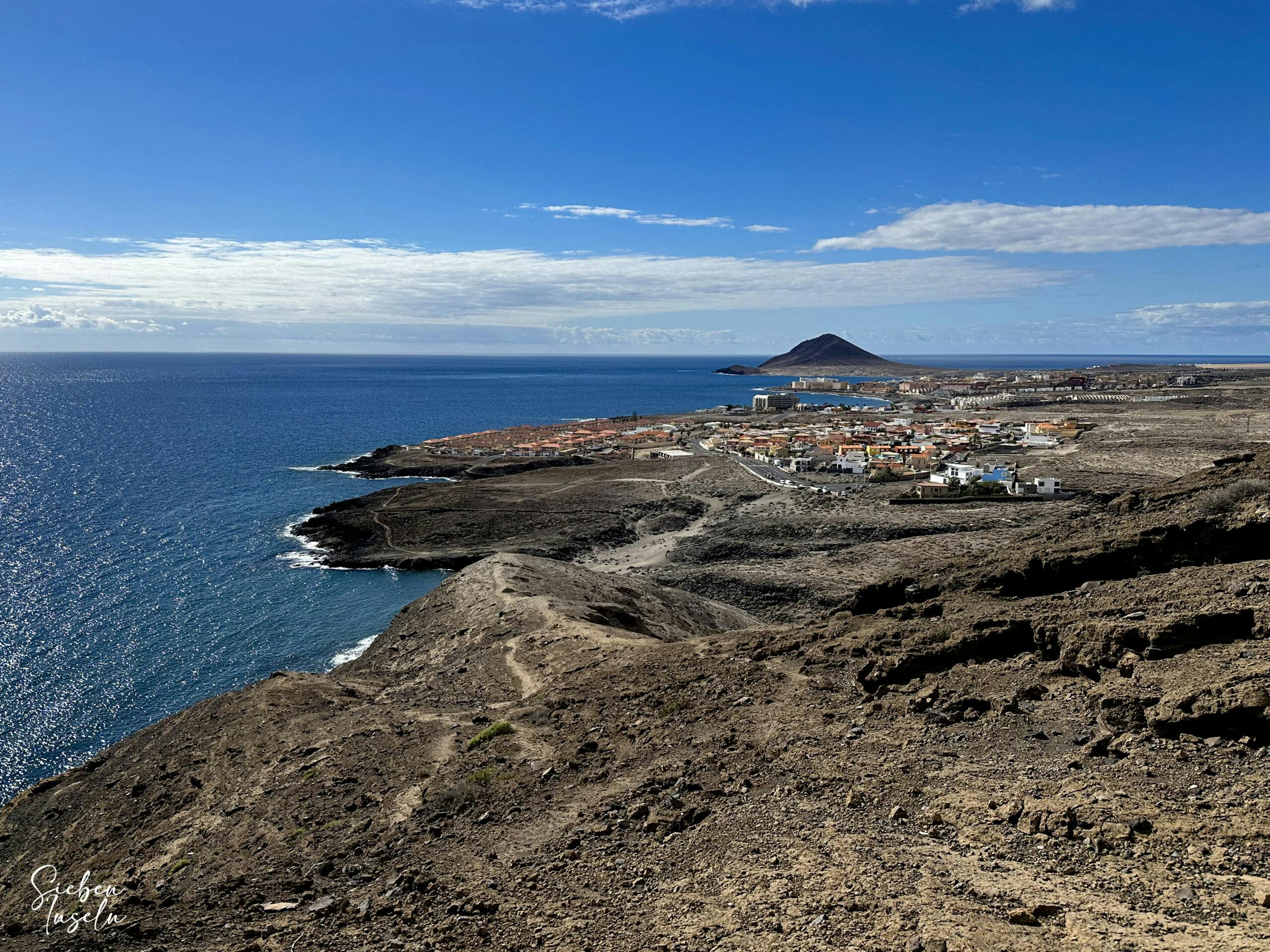
The steep front path quickly takes you up along the crater wall. After some time, the path flattens a bit. With splendid views of El Médano, the coast, and the Cañadas, you’ll quickly reach the crater rim. However, those who are not sure-footed or free from vertigo should better avoid this ascent path. Once at the top, you’ll find yourself on a broad circular path around the crater.
Hiking trail through an edge of the crater wall
Route Section from the Crater Rim of Montaña Pelada to the Descent Path
On the crater rim, you can go both left and right for the circuit. You can never miss the path. On this hike, I kept to the right first to enjoy the good views of the beach and the rocks. The path to your left around the huge crater initially leads downhill. The crater rim has collapsed a bit high above the hidden Playa La Rayita. So, you walk down and circumnavigate this cut along the impressive rock formations.
View of the large crater of Montaña Pelada
Afterward, the path goes uphill again slightly. To the left, a path branches off that goes right through the crater. If you don’t want to complete the whole circuit, you can cut through here. Otherwise, continue on the right path uphill. As you can see in my green track, you can also take a detour to look down at the hidden beaches. And for those who enjoy climbing, you can even descend to the secluded beaches from here. However, without adventure, you continue straight across the crater rim, from where you can now admire the port of Granadilla.
View from the crater rim towards Teide and Cañadas
Finally, you’ll reach the official descent path on the other side. Perhaps you’d like to finish the circuit around the crater first and choose a different descent. Or would you like to walk through the crater? This path also arrives at the point where the descent path begins. For you, this would mean going left downhill at this point.
View of the Montaña Pelada ascent path (way back)
Route Section from the Descent Path to the Parking Lot
If, like me, you want to descend on the red track on the normal descent path, the well-built path will slowly take you down to the foot of Montaña Pelada. Once down, you’ll have two options. There is a road called Calle Montaña Pelada, where you can comfortably return. After some time, to the left, the hiking trail towards the starting point branches off. To go towards the parking lot, then take the next right turn. Do not follow my red track. We just wanted to see where the path behind the houses might lead.
Path to the beach at the foot of Montaña Pelada
If you prefer something a bit wilder, after the normal descent, do not choose the road but the small path and hiking trail through the ravine at the foot of Montaña Pelada. This path leads in front of the volcano to the main path. If you want to go to the beach, you can continue straight. Otherwise, turn right onto a small path that takes you through the small ravine and then back up to the parking lot.
Hiking trail through the barranco at the foot of Montaña Pelada
And finally
I hope you enjoyed this truly short circuit hike around Montaña Pelada. Even though it’s very short in kilometers, it offers magnificent views of a truly interesting volcano. I hope you enjoy this and many other hikes on SiebenInseln. At the end of the article, you’ll find a small virtual coffee fund where you can leave a small contribution if you enjoyed it. Wishing you much joy in all your hikes,
Dagmar from SiebenInseln
Thank you for reading!
If you've found my hiking guides on SiebenInseln helpful for your Canary Islands adventures, please consider leaving a small tip. Your support is greatly appreciated and helps cover the costs of maintaining this blog.