4/24/2019 (updated: 10/28/2024) | 28min Reading time
El Bujero – rock gate with a fantastic view
DifficultyHard
IslandTenerife
Altitude470m - 950m
Distance7km - 13,7km
Circular hike
Head for heights
If you want to hike, have a great view and a bit of adventure, then the hike to the rock gate El Bujero is just right for you. There are several ways to reach El Bujero. Today I present a 7 km round tour from Tamaimo, for which you should plan about 4 hours with a stay in the rock gate. If you feel like a longer hike, you can start in Los Gigantes. There are two big alternative tours. But whichever tour you choose, from the rock gate El Bujero you have a fantastic view over almost the entire southwest coast of Tenerife, La Gomera and the Teno Mountains.
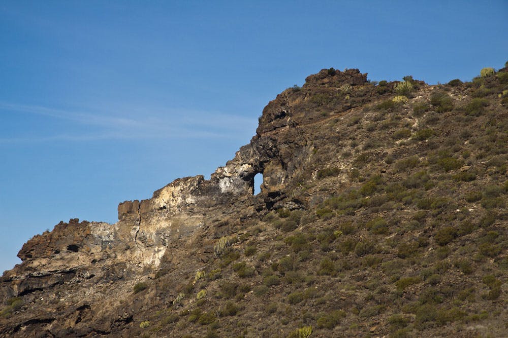
On the ridge. Here is the entrance to the rock gate El Bujero
Map
El Bujero is not the only rock gate in Tenerife. Especially when hiking in the Teno Mountains you will discover these impressive rock formations many times. But what makes the rock gate El Bujero so special? On the one hand it is visible from afar. You can see it lying down from the coast high up in the Teno rocks. From down there it looks like a very small hole in the rock. You won’t see how big and mighty it really is until you stand inside it. On the other hand, the rock gate lies far outside on a mountain ridge towards the Atlantic Ocean. Both sides are open and offer fantastic views in almost all directions.
Panorama view from the rock gate El Bujero
Rock Gate – El Bujero – The eye
Deep down lies the Atlantic Ocean and the town of Los Gigantes with its harbour. On the other side there are wonderful views over the Barranco Seco to its beach, where the Barranco Seco and the Barranco Natero meet. The neighbouring island of La Gomera lies outside in the Atlantic Ocean. To the south there is a wide view of the southwest coast of Tenerife. El Bujero is called the rock gate by the Spanish people. Locals also call it the eye or simply the hole. Whatever the right name, El Bujero has always been a popular hiking destination. But not everyone knows how to get there. Hiking trails lead nearby, but not directly to the rock gate. And since the entrance is really very hidden and not very easy to find, you have to either ask local insiders or read carefully here.
Track Tamaimo- rock gate El Bujero - Guama - Tamaimo
General information
Circular hike Tamaimo – rock gate El Bujero- Guama – Tamaimo
Starting point
Tamaimo main road or church
Directions by car: Main road TF 454, Carretera Puerto, sufficient parking available at the roadside in Tamaimo
By bus: Titsa Bus lines 325 (Puerto de la Cruz-Los Gigantes), 460 (Icod de los Vinos-Costa Adeje), 462 (Guía de Isora-Los Gigantes). More information on the Titsa Homepage.
Elevation profile for the hike from Tamaimo to El Bujero and via Montaña Guama back to Tamaimo
Time, altitude, challenge, refreshment and clothes
Hiking time
about three hours (with breaks and stay in the rock gate about 4 hours)
Track Tamaimo - El Bujero - Guama - Tamaimo
Difference in altitude
approx. 470 metres in ascent and descent
Challenge
Predominantly easy hike on good hiking trails and paths. The short section before and in the rock gate El Bujero alone requires full concentration, sure-footedness and absolute freedom from vertigo. On this section the path is extremely narrow and runs directly along the slope. If you don’t have the courage to do the last section, you can do the rest of the hike and enjoy a wonderful view on the ridge above the rock gate.
Refreshment
Bars, restaurants and cafés in Tamaimo, no refreshment on the way. Bring enough water with you.
track over the ridge with entrance to the rock gate
Clothing
As the hiking route partly runs off the beaten tracks, which are often a little overgrown with bushes, I recommend to wear long trousers and shirts on this tour, so that there are not too many scratches on the arms and legs.
Hike Los Gigantes – rock gate El Bujero- Los Gigantes
elevation profile Los Gigantes - rock gate El Bujero - Los Gigantes
Starting point: Los Gigantes
Track Los Gigantes - rock gate El Bujero - Los Gigantes
Arrival by car: park by the road in Los Gigantes or in the neighbouring district of Puerto de Santiago. If you can’t find a parking space at the side of the road, there is also a parking garage in Puerto de Santiago, Calle de Hondura or parking spaces with costs in the harbour of Los Gigantes.
Track Los Gigantes - Rock gate - Los Gigantes
By bus: bus line Titsa 325 (Puerto de la Cruz-Los Gigantes), bus lines 462, 493, 494 (Guía de Isora – Los Gigantes), bus lines 473, 477 (Los Christianos-Los Gigantes); bus line 477 runs directly and is therefore faster
Length, time, altitude
Route length: approx. 11 kilometres
Hiking time: approx. 5 hours
Article summary and large selection of GPS hiking tracks
Sign up for my newsletter now and get exclusive access to my collected GPS tracks as well as all the brief information about my articles.
Difference in altitude: 790 metres in ascent and descent
Track:two ways to cross the level between the ridges
Challenge, refreshment and clothing
Predominantly easy hike on good hiking trails and paths. The short section before and in the rock gate El Bujero alone requires full concentration, sure-footedness and absolute freedom from vertigo. On this section the path is extremely narrow and runs directly along the slope. If you don’t have the courage to do the last section, you can do the rest of the hike and enjoy a wonderful view on the ridge above the rock gate.
Compared to alternative 1, this hike requires more stamina, as it starts at the coast and goes over many metres in altitude and several kilometres.
Refreshments: Bars, restaurants and cafés in Los Gigantes, no refreshment along the way. Bring enough water with you.
Clothing: As the hiking route is partly off the beaten track, which is often a little overgrown with bushes, I recommend to wear long trousers and shirts on this tour, so that there are not too many scratches on arms and legs.
Hike Los Gigantes – rock gate El Bujero – Guama – Los Gigantes
Track Los Gigantes - rock gate - Guama - los Gigantes
Starting point: Los Gigantes
Arrival by car: park by the road in Los Gigantes or in the neighbouring district of Puerto de Santiago. If you can’t find a parking space at the side of the road, there is also a parking garage in Puerto de Santiago, Calle de Hondura or parking spaces with costs in the harbour of Los Gigantes.
Track Los Gigantes - rock gate - Guama - Tamaimo - Los Gigantes
By bus: bus line Titsa 325 (Puerto de la Cruz-Los Gigantes), bus lines 462, 493, 494 (Guía de Isora – Los Gigantes), bus lines 473, 477 (Los Christianos-Los Gigantes); bus line 477 runs directly and is therefore faster
Length, time, altitude and challenge
Route length: approx. 13.7 kilometres
Hiking time: approx. 6 hours
Difference in altitude: approx. 950 metres in ascent and descent
Challenge: Mainly easy hike on clear paths and paths. The short section before and in the rock gate El Bujero alone requires full concentration, sure-footedness and absolute freedom from vertigo. On this section the path is extremely narrow and runs directly along the slope. If you don’t have the courage to do the last section, you can do the rest of the hike and enjoy a wonderful view on the ridge above the rock gate.
Compared to alternatives 1 and 2, this hike requires a very good physical condition, as it goes over many metres in altitude and several kilometres.
Refreshment and clothing
Refreshments: bars, restaurants and cafés in Los Gigantes and Tamaimo. There is no place to stop in between. Therefore bring enough water with you.
Clothing: Since the hiking route partly runs off the beaten tracks, which are often a little overgrown with bushes, I recommend on this tour to wear long trousers and shirts, so that there are not too many scratches on arms and legs.
Hike Tamaimo – El Bujero
Varied circular hike with many vantage points
Tamaimo
After many hikes to the rock gate El Bujero this beautiful circular path is simply my favourite path. Because this tour is simply extremely varied and yet not too long. On this circular hike you will see phenomenal views and the rock gate, as well as the summit of Guama (877 m altitude) and the Cruz Misioneros (805 m altitude).
You can start the hike at the big crossroads in Tamaimo or at the easy to find church in Tamaimo (approx. 570 m). Those who start at the crossroads walk about 30 meters along the road towards Santiago del Teide. Then turn left onto Calle Santa Ana, which leads to the church. Continue straight ahead along Calle El Agua. Follow this road and take the next left. There is already a sign for the trail to Cruz Misioneros. Follow this and you will quickly reach Barranco Santiago via a small path.
Hiking route Tamaimo – Degollada del Roque
White rock Risco Blanco
In Barranco Santiago you will meet the Camino Real, which leads from Los Gigantes to Santiago del Teide (TF-65 marked yellow-white). Follow this road in the direction of Santiago del Teide. Cross the Barranco bed, climb up on the other side and turn right towards Santiago del Teide instead of left towards Cruz de Misioneros. You will return to this spot via the Cruz de Misioneros. The path leads uphill on the left side of the Barrancos over the village of Tamaimo.
After 1.5 kilometres you come to a fork in the road. Continue straight ahead towards Santiago del Teide. However, turn left and follow the TF-65.3 towards El Molledo. Now you go up the mountain in wide serpentines. After a short time you reach the mountain ridge (Degollada del Roque) at an altitude of 770 metres. In front of you rises the striking bright rock of the Risco Blanco. To the right, the path continues to El Molledo. But you go around to the left on the hiking trail. This leads you on the left side of the slope high above the Barranco Seco slowly descending on small winding paths to the west.
You can enjoy beautiful views of the Barranco Seco, the Risco Blanco and the Atlantic Ocean in front of you. The trail follows small paths along the hillside. High above you on the left you can see the Cruz de Misioneros, a white wooden cross. The path runs below this vantage point. After approx. 1.5 kilometres, the trail climbs a little bit steeply. At an altitude of 760 metres you have reached a large green sloping plateau. It connects the mountain chain that borders the Barranco Santiago with the mountain chain that borders the Barranco Seco. Here you can once again enjoy a great view. The large rocks along the way are perfect for a picnic.
Freshly fortified, you then always go along the mountain ridge towards the west (Atlantic Ocean). Here there is no signposted hiking trail anymore. Some hikers have left more and more colorful spray signs in the last years. Others have built up the classic rockmen. But the way is not always clearer. My tip is at this point. Keep as close as possible to the mountain ridge. If you get too far to the left to the plateau, it is quite difficult to find your way back to the ridge at some point. On the ridge it goes over rock plates, rocks, stones and very small ways. But in the meantime the way is quite good to find.
Hiking trail ridge Barranco Seco – El Bujero
view from the ridge to the neighbor island of La Gomera
Now comes the hardest part of the hike. Because the access path to the rock gate El Bujero is neither signposted nor easy to find. And if I am honest here, I have to admit that I searched for this place over a period of 2 years. I knew it existed and wanted to find it. But only when an older man described the place to me exactly, I managed to get to the rock hole one day. Maybe it was similar to other hikers. Since then more and more people seem to find their way here. Often and especially on the weekends many young Spanish people are on their way here.
here at the white marked stone is the steep entrance to the rock gate El Bujero
From the mountain ridge it goes right down a very narrow and extremely steep path. The entrance is between a cactus bush and a currently marked stone (see picture). You are about 700 meters above sea level and follow the narrow path on the slope above the Barranco Seco down to 650 meters above sea level. There you meet El Bujero, the hole, the eye. The experience of looking steeply down over the edge of the rock gate is unique. The view of the south coast of Tenerife, the Barranco Seco and La Gomera is phenomenal.
Hiking route El Bujero – Montaña Guama
the rocks of El Bujero
Article summary and large selection of GPS hiking tracks
Sign up for my newsletter now and get exclusive access to my collected GPS tracks as well as all the brief information about my articles.
After you have enjoyed the great view, you follow the same path from El Bujero back to the mountain ridge. You’ll have to make do a little without a fixed path. Now it goes up the ridge again on the way you came. To your right the sloping green plain spreads out. Here there are many possibilities and paths on which you can cross this plain. Some paths are a bit more comfortable than others. But they are all feasible. One of my preferred paths is marked with red spray points. You cross the plain to an altitude of about 750 meters and after a short time you reach a hiking trail again, the TF-65.2.
On the way you keep left and climb the mountain with its rocky and partly quite steep serpentines. It goes up from 750 to 877 meters. When you have almost reached the summit, a long panoramic path runs between bushes along the ridge. Then you stand on the summit of the Montaña Guama and can enjoy a wonderful panoramic view over the Santiago valley with the villages Tamaimo and El Molledo. In front of you the huge Risco Blanco and below you the Cruz de Misioneros.
Hiking route Montaña Guama – Tamaimo
view from Montaña Guama
From the summit of Montaña Guama at 877 metres above sea level, a narrow, sometimes steep and rocky path leads down the slope to Tamaimo. After descending 70 metres you can make a small detour to the Cruz de Misioneros on the left along a well signposted path. Here too, under the large white wooden cross, there is a fantastic view which, in good weather, also opens up a free view of the Teide. Below you in the Santiago valley you can see the colourful houses of Tamaimo lined up like building blocks.
From Cruz de Misioneros the path continues steeply downhill, so that you quickly lose altitude and approach Tamaimo. The last part of the way leads you over large rock steps down again into the Barranco Santiago. There you will come to the Camino Real, which you have taken in the direction of Santiago del Teide. Now all you have to do is cross the Barranco and you’ll be back in Tamaimo in a short time.
Hike Los Gigantes – rock gate El Bujero- Los Gigantes
Hiking trail Los Gigantes – circular hiking trail TF 65.2
Los Gigantes
The hike (identical outward and return route) starts at the bus stop or anywhere in Los Gigantes where you parked your car. There are three footpaths out of Los Gigantes. All you have to do is go uphill and out of town. In some places there are also signs for „Salida“ (exit). All three footpaths (two on the road, one on a slope) lead to the main road, Carretera General Puerto de Santiago, TF 454, which you follow straight uphill through a long serpentine.
Then you will pass the Mirador Archipenque. From there you have a magnificent view of the rocks and the whole cliffs of Los Gigantes. Continue along the road around a bend and after about 50 metres you will find on your left the PR-TF 65 (white-yellow with information board) to Santiago del Teide.
A small asphalted road climbs steeply uphill and then a few minutes further past some houses and banana plantations. Then the actual hiking trail (camino real) begins. This leads through the banana plantations and past a finca and a water reservoir to Tamaimo. The way is well signposted and leads you steadily uphill. To the left are the southernmost mountains of the Teno Mountains. After just under an hour’s walk, the TF-65.2 circular hiking trail branches off on the left.
After four kilometres you turn left off the hiking trail into the TF-65.2. A stony path leads you steeply uphill. You have already reached 400 metres in altitude and will reach an altitude of 760 metres in the next hour. But first you reach the Degollada de Tejera at an altitude of 542 metres. From there you can enjoy a first great view of the south coast. The path continues in serpentines and small rocky climbs steeply up to the top. At 575 metres, you will have a first glimpse of the mighty rock gate of El Bujero. At this point a small detour on an inconspicuous path to the left is worthwhile. There is a rock tooth of basalt visible from afar.
rock gate El Bujero
The main path leads you steeply uphill. At an altitude of approx. 750 metres there is a green sloping slope to your left. You have to cross it to the left. There are many possibilities and markings. No way is really dangerous. At best the bushes can get in your way from time to time. After you have crossed the plain, you are on the ridge above the Barranco Seco. From here the path is identical with the description above, which I insert here for clarification.
Rock gate El Bujero from the distance
Hiking trail ridge Barranco Seco – El Bujero
Now comes the hardest part of the hike. Because the access path to the rock gate El Bujero is neither signposted nor easy to find. And if I am honest here, I have to admit that I searched for this place over a period of 2 years. I knew it existed and wanted to find it. But only when an older man described the place to me exactly, I managed to get to the rock hole one day. Since then more and more people seem to find their way here. Often and especially on the weekends many young Spanish people are on their way here.
on the small path to the rock gate
From the mountain ridge, a very narrow and extremely steep path descends to the right. The entrance is between a cactus bush and a currently marked stone (see picture). You are about 700 metres above sea level and follow the narrow path on the slope above Barranco Seco down to 650 metres above sea level. There you meet El Bujero, the hole, the eye. The experience of looking steeply down over the edge of the rock gate is unique. The view of the south coast of Tenerife, the Barranco Seco and La Gomera is phenomenal.
On the same way, this tour will take you back again.
Hike Los Gigantes – rock gate El Bujero – Guama – Los Gigantes
Hiking trail Los Gigantes – rock gate El Bujero
Hiking route Camino Real Los Gigantes - Santiago del Teide TF-65
This alternative is the longest hike and offers besides the length a lot of hiking variety and also includes a large circuit. It is a combination of the first two hikes, so that I will list the corresponding sections one after the other at this point.
The hike from Los Gigantes to the rock gate El Bujero is absolutely identical to hike 4, so I don’t perform these sections again. But from the rock gate I don’t go back on the same way to Los Gigantes this time, but over the Montaña Guama (877 meters altitude difference).
Hiking route rock gate El Bujero – Montaña Guama
After you have enjoyed the great view, you follow the same path from El Bujero back to the mountain ridge. You’ll have to make do a little without a fixed path. Now it goes up the mountain ridge again on the way you came. To your right the sloping green plain spreads out. Now you already know that there are many possibilities and paths on which you can cross the plain. After you have done this, you will get back to the TF-65.2 hiking trail.
rock gate El Bujero
On the way you keep left and climb the mountain with its stony and partly quite steep serpentines. It goes up from 750 to 877 meters altitude. When you have almost reached the summit, a long panoramic path runs between bushes along the ridge. Then you stand on the summit of Montaña Guama and can once again enjoy a wonderful panoramic view over the Santiago Valley with the villages of Tamaimo and El Molledo. In front of you the huge Risco Blanco and below you the Cruz de Misioneros.
Hiking route Montaña Guama – Tamaimo
From the summit of the Montaña Guama at 877 m altitude, a narrow, sometimes steep and rocky path leads down the slope to Tamaimo. After descending 70 metres you can make a small detour to the Cruz de Misioneros on the left along a well signposted path. Here too, under the large white wooden cross, there is a fantastic view which, in good weather, also opens up a free view of the Teide. Below you in the Santiago valley you can see the colourful houses of Tamaimo lined up like building blocks.
view on the single rock and the south cost of Tenerife
From Cruz de Misioneros the path continues steeply downhill, so that you quickly lose altitude and approach Tamaimo. The last part of the way leads you over large rock steps down again into the Barranco Santiago. There you will come to the Camino Real, which you have taken in the direction of Santiago del Teide. Now you have to cross the Barranco and then follow the hiking trail in the direction of Puerto de Santiago down the valley at Tamaimo and partly also in the Barranco.
Hiking route Tamaimo – Los Gigantes
Now you can’t get lost, just follow the hiking trail TF-65 towards Puerto de Santiago. This will lead you along the right side of the Santiago Valley, leisurely down towards the coast. Shortly after Tamaimo you pass a goat farm on the hiking trail. Then you pass some ruined buildings and after a short time you reach the turnoff where your circular route TF 65.2 started. But now you don’t go up the mountain to the right anymore, but keep straight on the path that will take you back to Los Gigantes or Puerto de Santiago in less than an hour.
And finally
hiker in El Bujero with view to Los Gigantes
I hope very much that you can use the hiking trails for yourself and that the descriptions will be a good help for you. If you have any comments or suggestions for improvement, I would be happy to hear from you.
If you want to see a movie about the hike, just watch it here on Youtube.
I wish you a wonderful hike to the really impressive rock gate El Bujero,
Dagmar von SiebenInseln
Thank you for reading!
If you've found my hiking guides on SiebenInseln helpful for your Canary Islands adventures, please consider leaving a small tip. Your support is greatly appreciated and helps cover the costs of maintaining this blog.
[…] There I have already given a short description of this tour as a variant. Not far away are also the round tours over the Guama and to the rock gate El Bujero. The picture with the tracks gives you only a small impression of the many possibilities on […]
Arvid Berg - 08/09/23, 11:01 AM
I did the 7km version of this yesterday as I wanted something relaxing and easy going. Really great route, you are a master of these circular wonder routes, and I enjoyed it very much. Some of the route was closed, the part after the first climb up to the ridge (because of bird nesting), and the very last part going down from the cross back to the village (because of high risk of landslides). Also, after studying these maps and routes in detail, is not the ravine you look down in from this hike „Barranco Mancha de los Diaz“ (and not „Barranco Seco“)? I see that a lot of routes, videos and descriptions, including yours and even the signpost prohibiting part of the walk, is naming this „Barranco Seco“ and I just wanted to be sure about this.
Dagmar - 08/09/23, 01:05 PM
Arvid you are right. The real name is Barranco Mancha de los Diaz. But all Germans call it Barranco Seco – also the famous hiking guide Rother. So I use this short form as well 🙂
Arvid Berg - 08/09/23, 05:32 PM
Thank you! I see this a lot. As I mentioned including on the official Teno signs in the area. I want to try the upper tunnel route from Tamaimo soon and see if I cant get to the next tunnel to Barranco Natero / Seco (as far as I can tell the upper part is called Natero and the lower part is called Seco). From there I want to see if I can find the tunnel that takes you to the middle of the Masca ravine. Then on the way back maybe check out the „Windows of Barranco seco“ and see if I cant find the lower Tamaimo tunnel to go back. I see you have very up to date information on the tunnels from Puerto Santiago and Tamaimo, but have you heard anything about the other sort of „inner“ tunnels going all the way to Masca? If they are still accessible?
Beata Busko - 10/04/23, 11:13 AM
Do You think it would be ok to take 2 boys, 8 and 10 yrs? The route Tamaimo-El Agujero? Thank You
Dagmar - 10/04/23, 01:39 PM
Only if the boys are used to hike and climb
Volodymyr - 11/11/23, 04:50 PM
Did it today by „Track Tamaimo – El Bujero – Guama – Tamaimo“. It is very easy to follow – if there is sign „Path is closed“ – then you are on the right path 🙂
Thanks for this great hike and your comments for this hike. Did it for 2h 30 min (as a reference). Not recommend it for child (there are some dangerous parts on the path). GPS is recommended. Found a guy on „closed path“ who is got lost and decided to return to Tamaimo due to spending a lot of effort searching for the path to El Bujero.