Guest author Geert and the Degollada de Cofete
Since I rarely come to Fuerteventura myself, I am all the more pleased that a guest author, Geert, will be presenting a wonderful hiking tour here today. First to Geert about himself: My name is Geert and I live in Belgium. I have been running for many years (already over 60.000 km in total). Due to knee problems I discovered a new passion: mountain hiking. I am addicted to mountain landscapes, but also to the Canary Islands. I particularly like hiking on Fuerteventura because I have a family there.

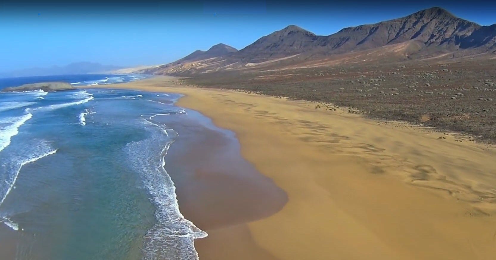
Playa Cofete
The highlight of this hike is on the mountain pass at the north face of the Gran Valle, the Degollada de Cofete. It connects the Leeward- and the wind coast of Fuerteventura. The view from there to the long coastline is breathtaking. If it’s not too windy, it’s the perfect place to stop before descending to Cofete.
Gran Valle – Cofete – Gran Valle – a hike for every taste
Map
The hiking trail from Gran Valle to Cofete was in former times the first and only connection between the lowland around Cofete and the south coast of the island. The Cofete region has always been more suitable for growing vegetables and livestock, while the south coast is drier and warmer.
You start the hike at a height of +/- 60 meters. The ascent to Degollada de Cofete (347m) is about 3.7 kilometers long and never very steep. Different the descent to Cofete is a bit steeper, but should not be a problem for those who are used to hiking. And the distance of the descent is pretty much the same as the distance of the ascent, but the path is completely different and winds from left to right along the steep side of the mountain.

Track of the hike Gran Valle - Cofete
General information about the hike Cofete
Starting point
The starting point is at 28.063420, -14.376363, which can be reached by bus, on foot or by car. My advice would be to take a car if possible. Because the first 1.7 km of the road are asphalted and the remaining 1.5 km to the parking lot in Gran Valle are not dangerous. However, depending on the additional walks you can take from Cofete, it may be a good idea to take the bus from Cofete back to the starting point.

Starting point of the hike - hiking sign Gran Valle - Cofete
Approach by car
If you visit Cofete by car, note that there are not only asphalted roads that are in a very bad condition from time to time. The further you go, the worse the road gets. Furthermore, almost all car rental companies prohibit the use of rental cars on this road. The insurance does not cover accidents or breakdowns and the renter is fully responsible.

CANCO Fuerteventura - Excursions and Sights
The approach is from Moro Jable. Follow the signs to Puerto de Jandia. Before reaching Puerto, turn right towards Punta de Jandia. After 3 km you will find yourself on the right hand side in the parking lot of the Gran Valle. You can’t miss it.
Approach by feet
For those who want to hike to the starting point: Leave your car where the road turns right to Punta de Jandia. There is a parking lot on the left side of the road. Immediately after the junction with Punta de Jandia you will see a red sign with the sign GR133, a long-distance hiking trail leading from Corralejo to Punta de Jandia. Follow the GR133 west towards Punta de Jandia. After 2 km you reach the Morro Jable cemetery. Follow the GR133 for about 1 km until the path crosses the road. Leave the GR133, turn right and follow the road for 400 metres. You will reach the starting point.
Arrival by bus
The bus is a special version adapted to the poor road conditions. Twice a day it goes from Moro Jable to Punta de Jandia. On the way back he makes a detour to Cofete. He stops at the parking lot of the Gran Valle. Always inform the driver where you want to be dropped off, otherwise he may not stop.
Details can be found on the Tiadhe website. In case of bad weather the service can be stopped. The bus is also a very good option to return from Cofete to Gran Valle. The bus stop in Cofete is right next to the only restaurant/café.
Time, distance and altitude difference
Times are always very individual. I don’t want to give my time because I am a person who walks too fast. To get a rough estimate, you can use Naismith’s Rule, named after William W. Naismith, which is often used as a clue to estimate the time it takes to travel distances in the mountains. The rule requires an appropriate level of fitness.
– Your normal walking speed on a flat surface
– Add 10 minutes per 100 meters of ascent.
– Add 5 minutes per 100 meters of descent.
Besides the main hike (Gran Valle to Cofete) there are several options to choose from.

All tracks of the hike around Cofete
Overview of all routes
Gran Valle to Cofete (one way) – distance: 6,4 km – total ascent: 362m – total descent: 354m

Elevation profile Gran Valle to Cofete
Time according to Naismiths rule, at a normal walking speed of 5km/h: 2h 15′.
The way back would be about the same.

Track Playa Cofete
Cofete to Playa Cofete (single distance) – distance: 1.1 km – total ascent: 1m – total descent: 55m

Elevation profile Playa Cofete
Article summary and large selection of GPS hiking tracks
Sign up for my newsletter now and get exclusive access to my collected GPS tracks as well as all the brief information about my articles.
Sign up nowTime according to Naismiths rule, at a normal walking speed of 5km/h: 16′.
The way back would be almost 20′.

Track El Islote - Villa Winter
Option Villa Winter-El Islote-Cofete – distance: 10,5 km – total ascent: 120 m – total descent: 249 m

Elevation profile El Islote - Villa Winter
Time according to Naismiths rule, at a normal walking speed of 5km/h: 2h 30′.
CANCO Fuerteventura - Excursions and Sights
Expect an absolute minimum of 3 hours – see description of hike: soft sand.

Track Cofete - Roque del Moro
Option Cofete-Roque del Moro-Cofete – distance: 10,2 km – total ascent 127 m – total descent: 127 m

Elevation profile - Cofete - Roque del Moro
Time according to Naismiths rule, at a normal walking speed of 5km/h: 2h 20′.
Expect an absolute minimum of 3 hours – see description of the hike: soft sand.
Requirement
An „appropriate“ fitness level should be sufficient for the main hike from Gran Valle to Cofete and back. Maybe it will be additional enough to go to Playa Cofete and back.
Both Villa Winter-El Islote-Cofete and Cofete-Roque del Moro-Cofete require a good physical condition.
From Villa Winter to the beach you have to find your own way, unless you take a detour. And from the beach to El Islote and back to Playa Cofete the sand is very soft, making it difficult and almost impossible to walk at normal speed. Also for the way to Roque del Moro there is only soft sand. When the tide is high, there is a place where you can’t walk on the beach and a 20 meter high hill that you have to cross without a clear path.
Refreshment
There is a restaurant/café in Cofete and many possibilities in Moro Jable. Therefore take enough water and food with you.
Variants
If you are curious about Villa Winter and/or El Islote, you can extend your walk: if you go down from Degollada de Cofete, you will have to cross a very small Barranco just before you are almost down, you have to cross a very small barranco. This is where the path to Villa Winter begins.

endless sandy beach at Roque del Moro
If you like a lonely but beautiful beach and an impressive view, you should go to Roque del Moro. You won’t regret it.

Hiking at the beach
Warnings
Although some people do, you shouldn’t swim here. There are strong undercurrents. Together with the big waves it is very dangerous.
When you go to El Islote: The small island is usually always accessible via a sandbank directly in front of it. If you go to the Roque del Moro, never try to reach the Roque del Moro itself or the area behind the Roque when the tide comes. This can rise very suddenly and very quickly. And there is no possibility to return. The only solution is to wait for the next low tide. If you cannot return, there is no beach behind the Roque del Moro, just rocks: you have to find a place where you are safe from the sea for the next 6 hours. During low tide it is safe there.

Hiking track Gran Valle - Cofete
Hike Gran Valle – Cofete
Section from the start to the Degollada de Cofete
What seems to be a long hike is in fact a pleasant walk through a long and dry valley in the Jandia Nature Park. This is the habitat of the cactus-like Euphorbia handiensis. A high percentage of these plants grow worldwide in Fuerteventura.

Cactuses Gran Valle - Islote
It is very easy to follow the path because it is well maintained, especially in recent years, while more and more tourists want to explore the island on foot. To the west you can see the Morro de Mungia mountains in many different colours, to the east the less impressive Cuchillo del Ciervon.
You will probably see goats and sheep. These animals are kept by some local farmers who live in the settlement la Solana shortly after the start.
The closer you get to the Degollada de Cofete, the steeper the path becomes, but it is never really difficult to walk.

Gran Valle - Caldera
Section Degollada de Cofete (no real section, but the highlight)
At the Degollada de Cofete you will meet the remains of the birth of Fuerteventura. The Jandía peninsula was originally a separate volcanic island consisting of a huge volcano, while the rest of the island of Fuerteventura consisted of several volcanoes welded together. The volcano Jandía was separated from Fuerteventura by a strait that filled further volcanic eruptions and formed the isthmus of La Pared, which today connects Jandía and Fuerteventura.

hiking path Gran Valle - Cofete
Article summary and large selection of GPS hiking tracks
Sign up for my newsletter now and get exclusive access to my collected GPS tracks as well as all the brief information about my articles.
Sign up nowAt its peak 14 to 15 million years ago, the Jandía volcano had a diameter of 26 kilometres and a height of 1500 metres: this would correspond to an area larger than La Gomera. The last eruption of the volcano Jandía about 12 million years ago caused a collapse of a large part of the crater in the Atlantic.

view from the degollada
You can see these geological events in the landscape of Jandía: peninsula in the form of a large mountain arc. The part of the caldera that survived the collapse, the northwest coast (typically the Arco de Cofete) with its steep cliffs falling into the sea, is the crater of the caldera. And the central summit corresponds to the edge of the caldera, with the Pico de la Zarza as the highlight. 
The Jandia peninsula - Cofete
Here the gentle slopes to the coast southeast and southwest correspond to the slopes of the volcano. These lava flows have formed ridges and the so-called Barrancos (gorges).

Jandia with mountains, beach and the sea
Section Degollada de Cofete to Cofete
The descent to Cofete requires special attention: the paths are smaller and in some places somewhat slippery due to small lava stones. If you plan to return on the same path, the ascent will be easier than the descent.

view to the long sandy beach Cofete
The path zigzags. Very soon the strong wind that you have experienced on the Degollada de Cofete will ease, the view is impressive: a black to light brown landscape, the mountain range, a yellow-white beach, white waves and a deep blue ocean under a blue sky. El Islote on your right, Cofete further left. In front of you is the beach of Cofete – recognizable by some cars in the distance. And in the middle of nowhere lies the mysterious Villa Winter.
After a 1.2 km descent, the descent turns into an easy walk to Cofete. The hamlet itself has little to offer: some houses and sheltered cabins with a bar/restaurant where you can have a refreshment or a meal.
Villa Winter
The mysterious Villa Winter is located 1.5 km east of Cofete, 130 m above sea level, almost at the foot of the Pico de la Zarza. The villa was built in 1946 by the German engineer Gustav Winter, who lived in Morro Jable. It was restored in 1985, but is still in poor condition. In 1939 Winter was called and in 1940 it became known that he was building shelters for submarines on the French Atlantic coast. The Spanish government was told 104 names of alleged NS agents at that time. This circumstance and his name on the black list of the Anglo-Saxon secret services, is the reason for the existence of many popular legends around the Villa Winter.
CANCO Fuerteventura - Excursions and Sights
Thus the Villa Winter was a secret base of Nazi agents who were to supply German submarines during the „Battle of the Atlantic“. The villa’s tower would have served as a point of reference for submarines; submarine shelters would be built in a volcanic grotto of the villa and there would be underground tunnels from the villa’s cellars to underground submarine shelters. Two submarines missing since the end of World War II would continue to berth at Cofete’s submarine base. And finally, Adolf Hitler himself would have walked through the Villa Winter. You can find more interesting information about Gustav Winter here. Maybe you would like to visit this interesting place. 
Playa Cofete
Short hike to Playa Cofete
If you want to hike and spend some time on the beach, a walk to Playa Cofete is a good idea. It is a flat path of about 15 minutes.
Hike to Villa Winter – El Islote – Cofete
10.5 km before you get to Cofete, you’ll be on an almost flat path on difficult terrain. This hike takes many hours – a walk on a soft sandy beach. Coming from Degollada de Cofete there is a path to a small Barrancos on your right. You can clearly see the path leading to Villa Winter. From there it is an easy walk to Villa Winter. But the second part is less easy. There is no way from Villa Winter to the sandy beach unless you make a long detour towards Cofete. The best solution is to follow a path from Villa Winter to a small settlement to the northeast.

path Islote - Villa Winter
Once there, you’ll see a village near the beach to the northeast. But there is no way. If you just walk straight ahead, you’ll have to cross countless lava stones.

path Islote (direct)
Arrived at the beach, you continue directly to El Islote. The view of the mountains compensates for the way. Especially the view in front of you is overwhelming on a clear day: The contrast between the blue water, the black/brown mountains and the white sand towards La Pared is wonderful.
On your return you will go straight to Playa de Cofete. You can also go back to Villa Winter to return to the Gran Valle car park via Degollada de Cofete.

beach at Roque del Moro
Hike from Cofete to Roque del Moro and back
This is undoubtedly a hike you will never forget. It is very easy to describe because a photo can say more than a thousand words. But be careful with the Roque de Moro (see warnings above). From Cofete, find a path (unpaved road) behind the restaurant and follow it towards the sea. Arrived at the beach, it goes west. Already now you can enjoy the view around you.

beach, the sea, mountains - Roque del Moro
During the first part of the hike you have a seemingly endless beach in front of you. You have dark mountains to your left hand and big white waves to your right.

Rocky coast near Roque del Moro
Soon you come to two ledges. The first one is almost always easy to pass on the beach. Depending on the sea level, however, you may have to go up the ledge. The second one can almost never be passed on the beach. You have to find your own way when you go over the ledges. Before you go down from the second ledge, you will suddenly see the beach behind it.

Roque del Moro
The closer you get to the Roque del Moro, the more you will be impressed by its height. If you are quite close, you can see the formation of the rock. Remember that the way back to Cofete and possibly to Degollada de Cofete and Gran Valle will probably take more than 3 hours, maybe even 4 hours.

Roque del Moro and Geert
And finally
Whichever way you choose:
Gran Valle to Cofete or Gran Valle to Cofete via Villa Winter and El Islote, or Gran Valle to Cofete with the Roque del Moro. I hope you will have a wonderful day on Fuerteventura in Cofete,
Geert