Barranco de Las Vacas – a well-known tufa gorge on the east side of Gran Canaria
The Barranco de Las Vacas, known by its name, was once an insider tip on Gran Canaria. Unfortunately, it has long since ceased to be so. In the social media, you can find an endless number of posts and pictures under the name. It’s an ideal place for photo shoots and therefore, unfortunately, too crowded at certain times. The so-called Barranco is located on the C-550 between Temisas and Agüimes. It is a canyon no more than 200 metres long, but its narrowness and colours make it a beautiful place worth seeing. I know similar and also larger canyons of this kind on Tenerife, but visitors can only get there by abseiling (fortunately).
Map
Hikers in the Barranco de Las Vacas
Barranco de Las Vacas means „Canyon of the Cows“. When people talk about the Barranco de Las Vacas today, and thus also here in the article, it is precisely this small section that is meant. But in fact the actual Barranco de Las Vacas is a large barranco that begins much further down at Aguayro. This small section is actually part of the Barranco de Barafonso. It runs together with several gorges and later forms the Barranco de Las Vacas with them. In the article, however, I refer to this small section as Barranco de Las Vacas, as this is the name by which it is known. However, because of the coloured tuff, the name „Tobas de Colores“ (Tuff of Colours) is more appropriate.
Hiking to the Barranco de Las Vacas
Since the Barranco de Las Vacas is located directly on the GC-550, many people simply drive there and visit it. Because of the beautiful light conditions in the gorge, you will also meet some photographers there. During my last stay in Gran Canaria, I wanted to see this well-known gorge as well. To combine the visit with a hike, we started in Temisas and hiked down towards Agüimes.
View of the coast from the hiking trail
In a small circular walk, we first looked at the so-called Barranco de Las Vacas with its unique rock formations. Afterwards, we did a circuit of the gorges that all end in the Barranco de Las Vacas. A real canyon tour before we went back to Temisas on the same way.
Temisas - Barranco de Las Vacas Hike Track
General information about the hike
Starting point and approach
The starting point of the hike is Calle Real in the small town of Temisas on the GC-550.
Starting point of the hike - the small village of Temisas
Arrival by car
You can get to Temisas both from the west (Santa Lucia de Tirajana) and from the east of Agüime on the GC-550. From the GC-550, drive down into the town. There is plenty of parking on the main street, Calle Real.
Arrival by bus
Bus 34 stops at Temisas on GC-550 in three different places. You will pass the last stop to the east on this hike anyway. More information can be found on the Guaguaglobal homepage.
Time
I don’t like to give general times for hiking tours, as the times are very individual. I needed 5 hours for the entire route, including a break and a visit to the Barranco de Las Vacas.
Article summary and large selection of GPS hiking tracks
Sign up for my newsletter now and get exclusive access to my collected GPS tracks as well as all the brief information about my articles.
Altitude profile of the Temisas - Barranco de Las Vacas hike
Altitude difference and route length
The difference in altitude is about 790 metres and the route is about 15.8 kilometres long.
Requirement
On the long ascent and descent from Temisas towards the round tour, you mostly walk on good hiking trails. This remains the case until Barranco de Las Vacas and shortly afterwards. Then the path becomes quite confusing for a while and is sometimes difficult to find. The descent to GC-551 is quite steep and difficult. The following ascent above the Barranco de Las Vacas and other gorges is different in terms of trail conditions. You start on narrow paths and end on a wide road. All in all, this hike is extremely varied in terms of the trail design, but it is more suitable for fit, sure-footed hikers.
Refreshment stops
Bars and restaurants can only be found at the starting point in Temisas. Therefore, please take enough water and, if necessary, food with you for the hike.
Variants
If you only want to see the Barranco de Las Vacas, you can do this by car and park on the GC-550 just above the entrance to the Barranco.
However, if you want to walk less than the route I’ve presented, you can also just walk the lower loop and park off to the side of GC-550.
If you want to do a longer hike, you can start directly from Santa Lucia de Tirajana. Then you first take the route I described from Santa Lucia via the Cruz Siglo. At the turnoff to Agüimes described in the article, just keep following the hiking trail to Agüimes in the direction of Temisas. And from there you continue with the description in the article.
Barranco de Las Vacas
Hike Barranco de Las Vacas
Temisas to Barranco Hondo section
You start your hike in Temisas on Calle Real. You walk downhill for quite a while in the direction of GC-550. After a while, the road becomes Calle los Blanquizales. The road meets the GC-550, which you cross. This is also where the bus stop is, so bus drivers can start the tour here. After walking about 50 metres along the GC-550, follow the S-40 trail uphill to the left towards Agüimes.
Terraced fields and meadows near Temisas
This first takes you up to a small ridge and then slightly downhill on the other side along the slope. From up here you can enjoy magnificent views of the Atlantic, the coast and the entire area around Agüimes. You reach a ridge above the Barranco Hondo. On a serpentine path you then go down into the Barranco. You cross the Barranco Hondo and walk uphill again on the other side on a path.
Cave houses in the Barranco Hondo
Barranco Hondo to Barranco de Las Vacas section
Once you have reached the top, you will come to a road. Follow this slightly uphill to the left. After a short while, the path forks and you go downhill to the right. The wider path ends at a house. Pass the house on your left and follow a narrow path downhill. After passing another house, you will come to the GC-550. Now go around to the left along the GC-550 for about 100 metres. Then, behind a driveway to a finca, the footpath branches off to the right.
Hiking trail above the Barranco de Las Vacas
Article summary and large selection of GPS hiking tracks
Sign up for my newsletter now and get exclusive access to my collected GPS tracks as well as all the brief information about my articles.
Follow the path downhill for a short while. Then you will come to a wide road again. Turn right and after a few metres you will come to a junction. This is where the circular route begins. Later you will come back from the right. Now keep to the left. A hiking trail leads you along the slope for some time. Finally, it runs in a tight curve of the GC-550 down into the Barranco bottom. Now you are in front of the so-called Barranco de Las Vacas.
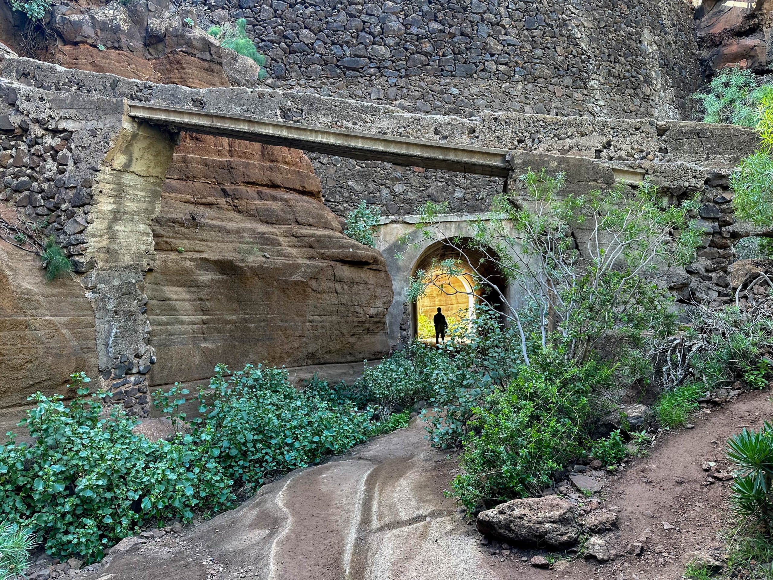
Hiking trail Barranco de Las Vacas
Barranco de Las Vacas to Barranco de los Charco section
The path in the barranco takes you through a tunnel under the GC-550 into the Barranco de Las Vacas gorge, which is about 200 metres long. Take your time and enjoy the narrow rocks and the beautiful colours of the gorge. I hope you don’t have to share the gorge with too many people. When you have seen everything, go back through the tunnel.
Hikers at the Baranquillo de los Charcos
A small path uphill to the left takes you up to GC-550. You walk a good 100 metres around to the left along GC-550. Then the trail branches off to the left uphill from the road. You walk over a ridge and finally come down the slope back to the GC-550. Now you go around it to the left for only a few metres. At the next bend, the trail branches off to the right downhill from the road into the Barranco de los Charcos.
View from the hiking trail to the tight curve at GC-551 and the village of Los Corralillos
Route section Barranco de los Charcos to GC-551
From here, the most difficult part of the hike begins in terms of the route. You walk down the left side of the Barranco de los Charcos for a long time. You recognise a small path and now and then a cairn. But since the path is also overgrown, this section is really something for „path seekers“. Shortly before the old buildings, you change the side of the barranco and reach the opposite side of the slope.
Hiking down to the Barranco de las Vacas (Melosas)
After some time, the path descends to the left across terraced fields. The route is still quite unclear. But eventually you reach the ridge and find a path there. This takes you along the ridge down to GC-551, where the road curves tightly. In the middle of the bend, your hiking trail branches off to the right into the Barranco de Las Vacas.
Ascent Barranco de las Vacas (Melosas)
Route section GC-551 to branch off return route
To the left and right of the GC-551 in this narrow bend is the actual Barranco de Las Vacas. I have already written everything above about the naming of the barranco. Now you climb on a narrow path on the right side of the slope for quite a long time above the barranco (also called Barranco de las Melosas in some maps). From up here you have beautiful views of the Barranco. Finally, the path takes you down into the gorge. Follow the course of the gorge for a short time.
Hikers on the ascent Barranco de las (Vacas) Melosas
Then a path on the right side of the slope leads you uphill again. You will now reach a smaller gorge, which you follow for quite a while. Finally, you can get out of the gorge on a small path uphill on the right. At the top you will come to a track. If you don’t want to go steeply uphill, you will meet the same track if you continue straight ahead in the gorge. Follow this road around to the right for quite a long time. The path takes you first uphill and then down into the barranco.
Hikers on the ascent path towards Temisas
Afterwards, the path goes uphill again on the other side. For a long time you will walk uphill on a ridge on this track between two gorges. Finally you arrive at the place where you turned right onto the path to the Barranco de Las Vacas. This is the end of the circular route. Now turn left and go uphill on the same path you came from, back to Temisas.
View from the ascent path to Temisas
And finally
I hope you enjoyed this hike to the Barranco de Las Vacas. In my eyes, this tour offers an ideal opportunity to combine a visit to the famous gorge with a varied gorge hike through some barrancos. I wish you lots of fun on all your tours,
Dagmar from Siebeninseln
Thank you for reading!
If you've found my hiking guides on SiebenInseln helpful for your Canary Islands adventures, please consider leaving a small tip. Your support is greatly appreciated and helps cover the costs of maintaining this blog.