The small village of Tejeda is the second smallest on the island of Gran Canaria. Approximately 1800 residents (as of 2022) live here at an altitude of 1050 meters. The main source of income for the inhabitants is tourism, as agriculture alone is not an easy livelihood in this remote high-altitude location. Every February, the traditional Almond Blossom Festival is celebrated in the village. The typical Canarian village of Tejeda, situated on the slope of a crater, is surrounded by picturesque terraced fields, orchards, and farmland. In the surrounding caves, numerous archaeological remains, such as ancient cave drawings by the indigenous people, can still be discovered.
Map
Hiking trail through Tejeda
The described hike takes you from the Mirador Degollada de Becerra down to the village of Tejeda. If you like, you can take your time exploring the beautiful old historic town center. Afterward, you ascend to the well-known Cruz de Tejada, the geographical center of Gran Canaria, on the slopes. From there, you can hike back, perhaps after a short rest, along a ridge trail with magnificent views to the Mirador Degollada de Becerra.
the stone cross in Cruz de Tejeda
Cruz de Tejeda – Geographical and Touristic Center of the Island
The location known as Parador Cruz de Tejeda is situated on a ridge of a mountain pass at an altitude of 1580 meters above Tejeda. There, you will find a large dark stone cross marking the geographical center of the island. Around Cruz de Tejeda, you’ll find beautiful green landscapes. Plant enthusiasts can enjoy hundreds of endemic plants, and the blooming landscapes look especially beautiful in spring. However, it’s worth noting that this popular viewpoint is surrounded by many tourist restaurants, bars, and souvenir shops catering to all tourist needs. Just a few meters from Cruz de Tejeda, solitude begins on well-maintained hiking trails.
Green surroundings near Cruz de Tejeda
Especially on weekends, Cruz de Tejeda can be very crowded, as locals also gather here for coffee and walks, in addition to the many tourists. There are many local specialties, such as honey, available for purchase. Cruz de Tejeda is also a major hiking intersection with many trail options. The paths are all well-signposted on large boards. During this hike, you are free to take a short detour (300 meters from the trail) to Cruz de Tejeda.
Track of the Cruz de Tejeda hike
General Information about the Cruz de Tejeda Hike
Starting Point and Access
You start your hike at the Mirador Degollada de Becerra car park on the GC-150 at KM 2.3 at an altitude of 1550 meters. Parking spaces are available at Mirador de Becerra.
Starting point of the hike - Mirador Degollada de Becerra
Driving Directions
You can reach the central part of the island from all sides. You can either come via Artenara and the GC-15, which will take you to Mirador Degollada de Becerra via the GC-150. Or you can come from the east and choose various routes leading to the GC-150.
Bus Access
There is no bus service to Mirador Degollada de Becerra. Therefore, you can only reach it by car (possibly taxi).
Article summary and large selection of GPS hiking tracks
Sign up for my newsletter now and get exclusive access to my collected GPS tracks as well as all the brief information about my articles.
I prefer not to provide general time estimates for hiking tours, as times can vary significantly. We took 3 hours and 45 minutes for this round, including breaks and a visit to Cruz de Tejeda.
Elevation profile of the Cruz de Tejeda hike
Elevation Difference and Distance
The elevation difference is approximately 670 meters, and the distance is just under 12 kilometers.
Requirements
You hike the entire time on well-maintained hiking and dirt roads. There are no exposed areas, but due to the length and elevation gain, good fitness is recommended. For this reason, I have classified the hike as moderately difficult.
Refreshments
Restaurants, bars, and shops are available in Tejeda (a short detour is necessary) and at Cruz de Tejeda. However, please carry enough water and snacks for the journey.
Track of the Cruz de Tejeda hike (green) and Degollada de Becerra panoramic circuit (blue)
Variants
Mirador Degollada de Becerra, Tejeda, and Cruz de Tejeda are veritable hiking intersections. There, you will encounter a flood of signs for hiking trails.
Paved hiking trail downhill towards Tejeda with a view of Roque Nublo
Circular Hike Cruz de Tejeda
Section from Mirador Degollada de Becerra to Tejeda Culata Junction
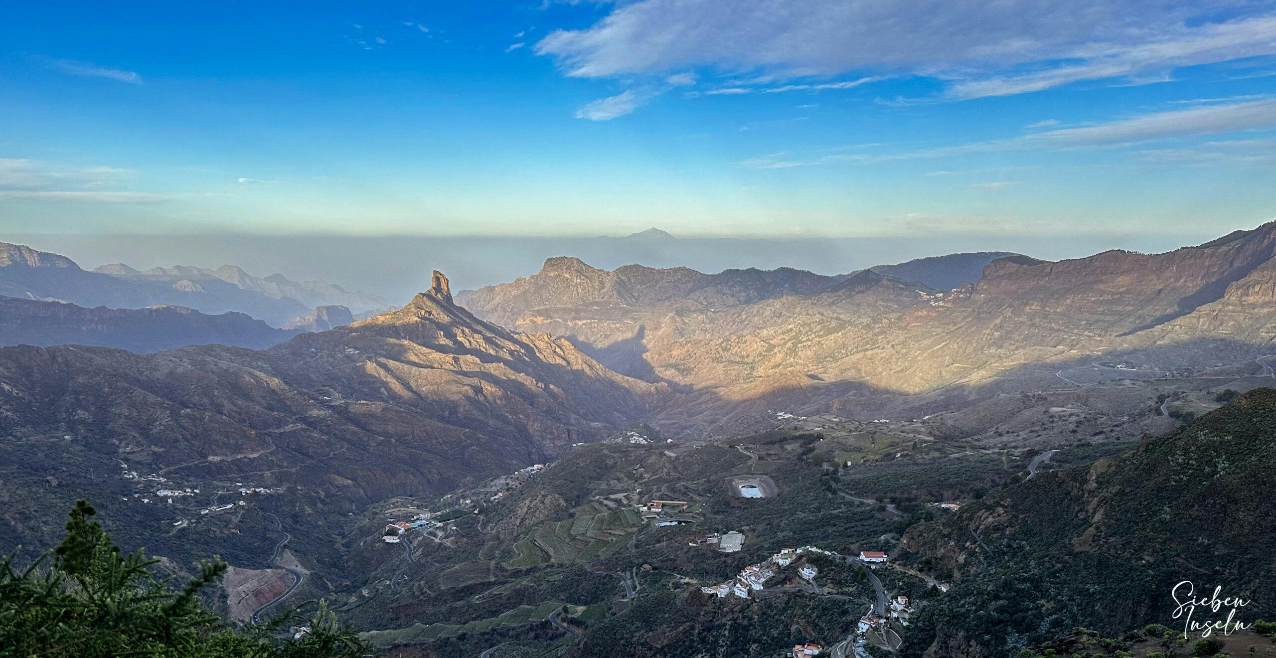
You start your hike at Mirador Degollada de Becerra and follow the hiking trail uphill along the Cumbre. Even though Cruz de Tejeda is signposted in the other direction, you initially follow the GR 131 towards Playa del Burrero or the GR 138 towards Los Llanos de La Pez. The path takes you over the Cumbre for some time with magnificent views of Roque Nublo and the surrounding ridges.
Start of the hiking trail at the Mirador Degollada de Becerra
Initially, you ascend, and then you continue at a consistent altitude for some time. Then the path turns left, and immediately afterward, your hiking trail branches off to the right. Occasionally, the path is marked as S-85 Circular de Tejeda – Cruz de Tejeda. In any case, it takes you quickly downhill on large stone-paved switchbacks. At a junction, you turn left towards Culata. However, you keep to the right downhill towards Tejeda.
Article summary and large selection of GPS hiking tracks
Sign up for my newsletter now and get exclusive access to my collected GPS tracks as well as all the brief information about my articles.
You now hike for a long time, first on the left and then on the right side of a mountain ridge downhill. During this time, you can enjoy magnificent views of Roque Nublo and, in clear weather, all the way to Tenerife. Finally, the path merges onto a road, which you follow to the right for a short time. Before a water reservoir, the hiking trail leaves the road to cut across the road with a switchback ridge path. You cross the road again. Then, the hiking trail, well-signposted, continues downhill towards Tejeda. For a long time, you follow the unmistakable downhill hiking trail.
after the road, the hiking trail starts again at this point over the ridge down to Tejeda
Finally, the hiking trail merges into a dirt road, which, after a short time, brings you to the GC-60. You could follow the road to the right towards Tejeda. However, it’s nicer to ascend immediately to the right between the houses. There, you will meet the hiking trail towards Tejeda. You follow this trail above the slope parallel to the road until you descend to the GC-60 at a restaurant. Now, you are in Tejeda.
Section from Tejeda to GC-156 Road
In Tejeda, you follow the GC-60 for a while and see a bit of the town as you pass through. You also pass over the historical center. If you want to take a closer look at the town, you should turn left. The hike takes you over the center to the right on a dead-end street. From this street, the well-signposted hiking trail S-85 towards Cruz de Tejeda branches off. The trail forks again with various signs to Cruz de Tejeda. Keep to the right and choose the path Cruz de Tejeda via Isa.
View back to Tejed
The hiking trail now winds past fields and individual houses on the slopes. The ascent is relatively moderate. After crossing the GC-608 and another ascent, you pass by the large building of Finca Isa. Shortly afterward, you cross the GC-156 twice more. The hiking trail, well-signposted each time, continues on the other side.
Finca Isa
Section from GC-156 Road to Mirador Degollada de Becerra
Now, on wide switchback paths, you continue moderately but constantly uphill along the slopes. You pass by the Tejeda viewpoint and shortly afterward cross the GC-15 twice. High above the GC-15, you eventually reach a hiking intersection. Straight ahead, in a few hundred meters, you will reach Cruz de Tejeda. A detour to the geographical center of the island may be worthwhile, perhaps combined with a coffee break.
Hiker on the ascent path to Cruz de Tejeda
After visiting Cruz de Tejeda, you return a short distance and keep to the right towards Mirador Degollada de Becerra. Initially, the hiking trail continues uphill on the ridge for a while. You can enjoy splendid views in all directions. Finally, the path descends towards Mirador Degollada de Becerra. Afterward, you pass through a small gorge and then descend to the starting point, the parking lot.
Hiking trail down to the Mirador Degollada de Becerra
And finally
I hope you enjoyed this beautiful circular tour around Cruz de Tejeda. You can combine it with many other hikes in the vicinity and find the right tour for you. Spectacular views are guaranteed. Enjoy all your hikes,
Dagmar from SiebenInseln
Thank you for reading!
If you've found my hiking guides on SiebenInseln helpful for your Canary Islands adventures, please consider leaving a small tip. Your support is greatly appreciated and helps cover the costs of maintaining this blog.