Circular walk from Santa Lucia over the Fortaleza and the reservoir La Sorrueda
On this diversified round tour, which starts in the mountain village Santa Lucia at an altitude of approximately 710 metres, you will get to see a lot of things besides the Canarian villages Santa Lucia and La Sorrueda.
Map

La Sorrueda
The hike takes you to the famous rock fortress La Fortaleza with a large cave and a large circular path from which you can enjoy magnificent views. You will walk along the old Ruta de la Sal and you can visit a museum about the history and the excavations at La Fortaleza.

Hiking trail along the road
Afterwards you will walk high above the Sorrueda reservoir with magnificent views of the lake, the dam, the green Barranco Tirajana and the surrounding mountains and hamlets. Via the small village of La Sorrueda and past a very large goat farm, we then head back towards Santa Lucia. And then there are the wonderful views from the Mirador de Sorrueda and the Mirador de Ingenio, which you can enjoy on the way back.

Hiking trail below a large goat farm between La Sorrueda and Santa Lucia
Santa Lucia, the Barranco Tirajana and a world heritage site
The whole area around the Barranco Tirajana and the reservoir La Sorrueda appears green and fertile. Immediately after the Spanish conquest of the island, sugar cane was cultivated here in the valley and its surroundings. Today you will rather find cattle farming, fields and large olive and palm groves. Especially the Canarian date palm is typical for this area. Among other things, it provides the necessary shade for the fertile soil on which a wide variety of fruits and vegetables are grown in this area. The palm trees also serve as wind protection. They are used for animal feed and large mats and wickerwork are also made from them in the area of Santa Lucia.

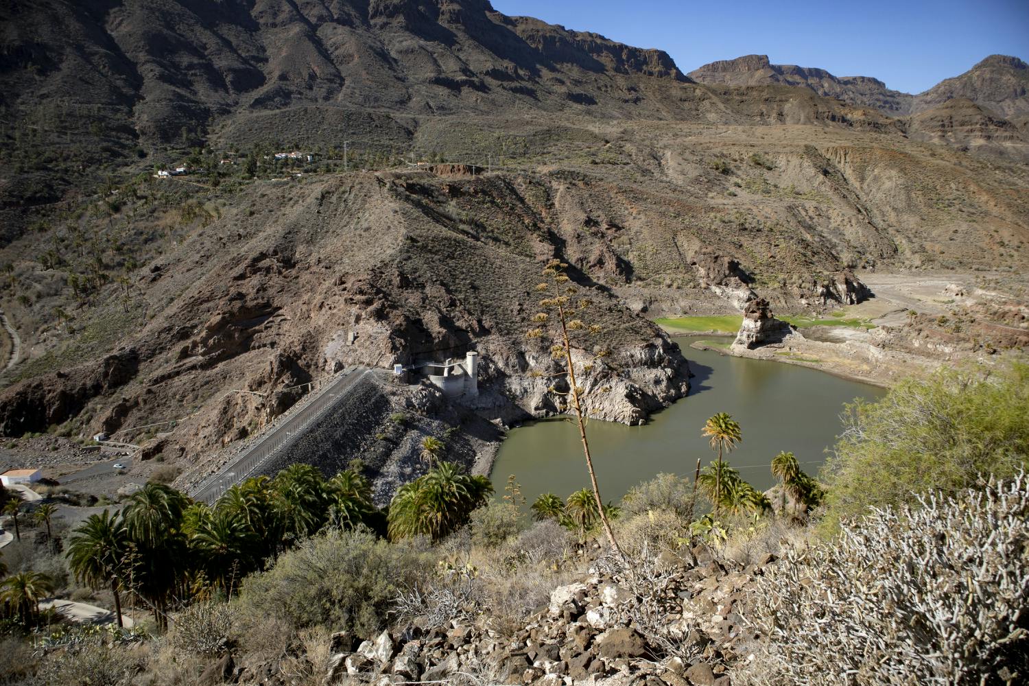
View of the La Sorrueda dam and El Sitio de Abajo
The La Sorrueda reservoir was completed in 1974. The entire area around the Barranco Tirajana has been a UNESCO World Biosphere Reserve since 2005. But also the history of this area goes back a long way. The natives retreated into the big caves of Fortaleza while fleeing from the Spanish. On this hike you can get an idea of the impressive rock massif and afterwards learn more details and information about the history of Fortaleza in the neighbouring museum.
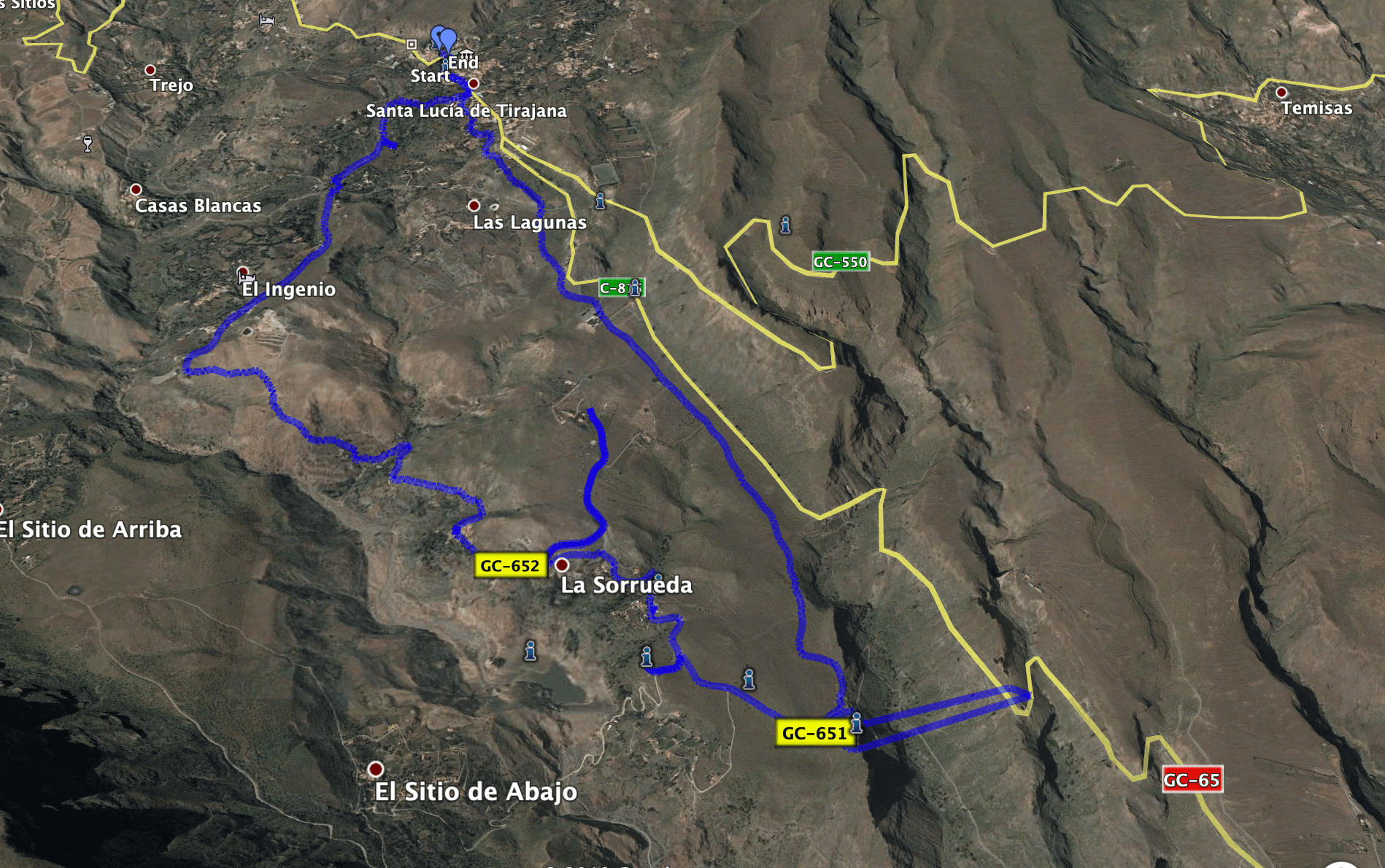
Track of the hike Santa Lucia - La Fortaleza
General information about the circular hike Santa Lucia – La Fortaleza

Starting point - parking lot Santa Lucia
Starting point and approach
Starting point of the walk is the parking lot/bus stop in Santa Lucia below the church square on the main street Calle Maestro José Enríque Hernández (GC-65).
Access by car
You can get to Santa Lucia from the coastal highway GC-1 by taking the GC-60 or GC-65 or GC-550. There are many ways to reach Santa Lucia, depending on where you are coming from. But even if you do not have a navigator, the well-known small town is very well signposted.
Arrival by bus
The bus number 34 stops right at the starting point of this hike. If you need more information about bus connections to Santa Lucia, you can look here. Article summary and large selection of GPS hiking tracks
Sign up for my newsletter now and get exclusive access to my collected GPS tracks as well as all the brief information about my articles.
Sign up nowTime
I don’t like to give general time information for hiking tours, because the times are very individual. We needed about 4,5 hours for this round with breaks. If you want to spend a lot of time at the Fortaleza or afterwards in the museum, the tour will of course take a little longer.
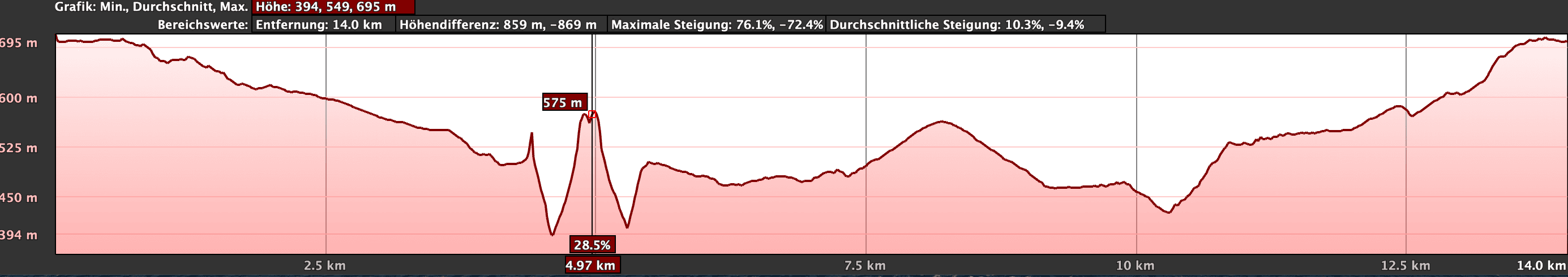
elevation profile of the hike Santa Lucia - La Fortaleza
Difference in altitude and length of the route
The difference in altitude is about 320 meters in ascent and descent. The route is about 14.5 kilometers long (with a small detour, which I took and which you can also use as a shortcut – you can find the exact description in the article)
Request
Because of the length of the hike you need a bit of fitness. And the ascent at the end is also a bit strenuous. But apart from that it is an easy and well manageable hiking tour on well laid out hiking trails.
Refreshment
Restaurants, bars and shops are mainly in Santa Lucia and La Sorrueda. But please take enough water with you for the trip.
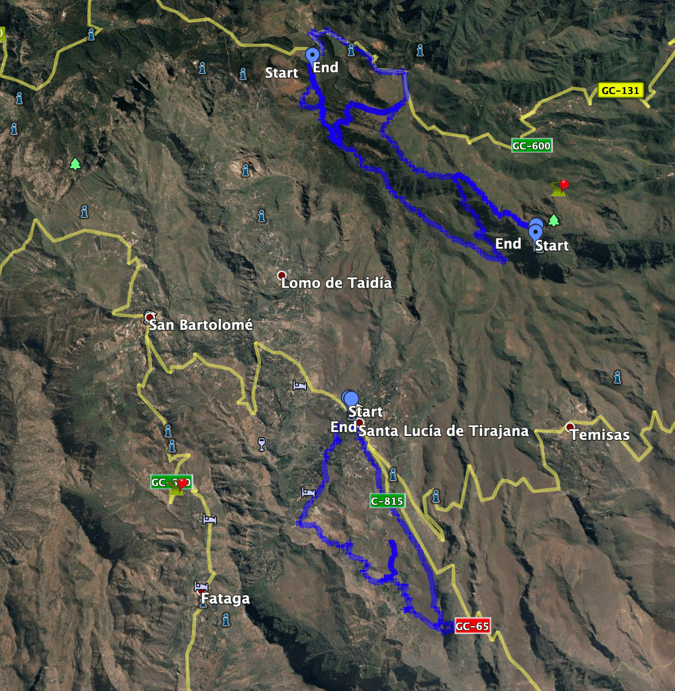
tracks of the hike Santa Lucia - La Fortaleza and Barranco Guayadeque
Variants
This tour can be easily combined with various other hiking and circular walks in the vicinity. Santa Lucia is a real hiking hub. From there you can walk in all directions. From Santa Lucia you can walk uphill on different hiking trails, so that you can also get to the hiking trail of the hike through the Barranco de Guayadeque. If this tour is too long for you, I also present below a shortcut that you can use either on the way there or back. You can also see the exact route by looking at the picture of the track.

La Sorrueda Reservoir
Santa Lucia – La Fortaleza – La Sorrueda circular route
Section Santa Lucia Parking until crossing the GC-653 below Santa Lucia
You start this circular walk in Santa Lucia on the main street Calle Maestro José Enríque Hernández at a parking lot below the church square. It is worthwhile to climb the stairs for a short while and have a look at the church and town hall square with its views over the town and the surroundings. After that, one walks alongside the main road GC-65 in southern direction. After a short time, you will see at the left side of the street a big building that reminds on a knight’s castle or fortification. This is the Hao (museum and restaurant). Exactly at the opposite side, you turn right into the Calle Juan del Río Ayala.

Road junction hiking trail Santa Lucia into Calle Juan del Río Ayala
Follow this street to the end and then turn right slightly downhill on a wide path. After you have circumnavigated two farmsteads, take a cemented path and turn left at a fork. Shortly afterwards you will come to a wider cement road, which you follow to the right. At the next fork, keep left and follow the path that runs parallel below the GC-65. You can recognize this fork by a prominent palm tree. Afterwards you walk on the narrow path through a number of cacti, which are on the right and left side of the path. Follow the path downhill and cross the GC-653.

Junction hiking trail below Santa Lucia with palm tree
Section Crossing the GC-653 below Santa Lucia to the Camino de la Costa junction
Article summary and large selection of GPS hiking tracks
Sign up for my newsletter now and get exclusive access to my collected GPS tracks as well as all the brief information about my articles.
Sign up nowAfter crossing the GC-653, the hiking path continues at the other side of the road. You walk downhill underneath the road and can already enjoy some good views into the wide green valley. From time to time, there are some old signpostings to the Fortaleza. Finally, the path ends on the road GC-651 that you follow to the right. Your way leads you past the cemetery. After a short time the GC-651 turns right. Here you can – if you want to take a short cut – walk along the way there and back. But the footpath will take you to the left towards La Fortaleza.

Hiking trail along the slope
Now, there are also some old wooden signpostings to the Ruta del Sal. This short section of the hiking tour is a part of the Ruta de la Sal on which once the salt was transported. But at the next fork, the Ruta de la Sal turns right. You continue straight on past fenced fields. Afterwards, you continue downhill on this well-prepared trail with magnificent views. In front of you you can already see the famous Fortaleza rocks, which consist of the Fortaleza Chica and Fortaleza Grande. You come to a fork where the Camino de la Costa branches off to the right as you continue straight on.

View of the hamlet El Sitio de Abajo
Junction of the Camino de la Costa to road GC-652
Shortly after the fork you will come to a larger open space in front of Fortaleza with a large information board. From here you can now go up to the Fortaleza and look at the striking rocks with the indescribable views. You can climb up to the 25 meter long cave and then walk around La Fortaleza. A picnic is also possible at this special place. Once you have seen everything, you continue on the road GC-651 in direction to Sorrueda. After some time, a signpost on the left points to the Mirador de Sorrueda.

La Fortaleza - Cave in the rock fortress
You leave the road to the left and after a short time you arrive at the Mirador, from where you can enjoy an impressive view to the big dam wall and the reservoir. Then you go back to the road and turn left again. Now, after a short time, you get to the Centro de Interpretacíon de las Fortalezas. If you like, you can now get detailed information about the Fortaleza or visit the nearby restaurant El Alpendre de Felíx. Follow the road GC-651 until you reach a wide left turn. Here the hiking trail leaves the road to shorten the wide bend. The path bypasses a small farmstead and later on brings you back uphill to the road GC-652. Don’t worry – there is hardly any traffic on these small roads. 
View from the Fortaleza
Route section road GC-652 to road GC-653
When you reach the street, you should keep left. As you can see from the track, I went right first. I wanted to see if there was a connection to the way there. And yes, if you want to shorten the hike, you first follow the road GC-652 and then turn left to the road GC-651 and come out at the fork just below the cemetery (outward way). But if you want to do the whole hiking tour, you have to turn to the left and after a short time you will get to the really picturesque hamlet La Sorrueda. La Sorrueda is also an ideal place to rest.

Museo La Fortaleza am Wanderweg
From La Sorrueda, one continues to follow the road GC-652 that then changes into a normal driveway. The hiking path leads alongside the hillside and finally brings you past a big goat farm and palm groves into the Barranco ground. From there, the hiking path climbs a little steeper uphill passing a farmstead. On the hillside, the trail climbs steeply over red rocks on narrow paths. The views back to the lake and the surroundings are impressive. At the end of this ascend, the path flattens and you get to the road GC-653.

Bushland with fincas below Santa Lucia
Route section road GC-653 up to the starting point in Santa Lucia
Continue to follow the small road that runs through the outer areas of the hamlet of El Ingenio. On the left, a road goes down to the centre. But you go straight on. Continue straight on along the small road that will take you up to the Mirador de Ingenio. From here, you can enjoy once again some wonderful views of the whole surroundings. From the Mirador, you do not follow the road any more but the hiking path to the left behind the Mirador downhill. At the bottom, keep right and follow the path that now takes you relatively steeply up the mountain.

Hiking trail past some fincas below Santa Lucia
Before this path makes a sharp left turn, there is a narrow path on the right side. Follow this path up the mountain. It takes you through palm tree forests and past the first estates of Santa Lucia. Then the path turns into a small street (Calle La Montañeta). This leads into Calle Juan del Río Ayala, through which you have already passed on your way there. Take a few steps to the left and you will find yourself back on the main street of Santa Lucia. In a short time you can turn left to get back to your starting point, the parking lot/bus stop.

Hiking trail past some fincas below Santa Lucia
And finally
Even though at the moment (April 2020) hiking is forbidden in Spain because of the state of alert due to the Corona virus, I hope you enjoy this hike and that you may be able to walk it again soon. Stay healthy and have fun during all your hikes,
Dagmar of SiebenInseln