Pico Bejenado – volcanic peak with an impressive view
Pico Bejenado is a volcano with a 1854-metre peak that is said to be about 500,000 years old. Seen from El Paso, it looks like a green forested mountain in the landscape. In fact, however, it is part of the mighty cumbre above the Barranco de las Angustias. Pico Bejenado rises on the southern edge of the Caldera de Taburiente between the Barranco de El Riachuelo, the Barranco Tenisca and the mighty Barranco de las Angustias. Map

View of the green forested Pico Bejenado from El Paso
To get from Pico Bejenado to Cumbre Nueva, you have to cross the La Cumbrecita pass, which separates the two mountain ranges. Due to its beautiful view, Pico Bejenado is one of the most popular mountains on La Palma. Therefore, you are guaranteed not to be alone on your hike and will meet many fellow hikers; this is especially true at weekends. From the summit, and also from a peak in front of it, you can enjoy a fantastic view of the Caldera de Taburiente, the Barranco de las Angustias and the entire surrounding area.

Information board at the Pista de Valencia
Hike to Pico Bejenado
There are several ways to get to the top of Pico Bejenado. To make the hike a little more varied, we took a circular route most of the way. Only the actual ascent to the summit can be done on the same path. You start the hike via El Paso. You can decide for yourself how far you want to climb or, if necessary, how far up you want to go. But even if you start high, the ascent remains a little steep.

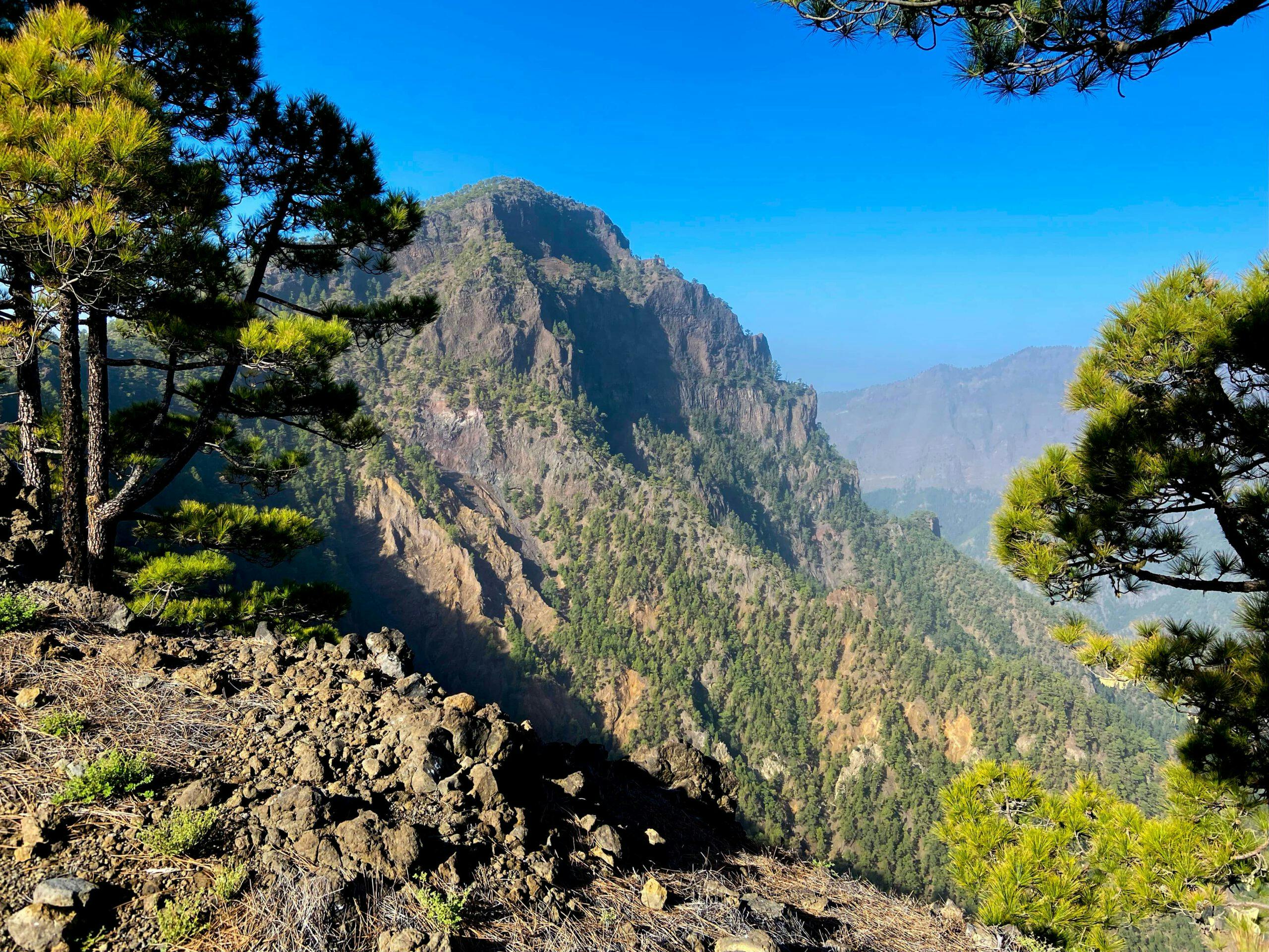
View into the enormous basin and the Barranco de las Angustias from Pico Bejenado
On the round tour, you first climb the Roque de los Cuervos (1603 metres). From up there you have the first wonderful views down to the Cumbrecita and into the Caldera de Taburiente. If you like, you can also start the hike at the Cumbrecita and then hike up the well-marked hiking trail to Roque de los Cuervos. From the Roque de los Cuervos, the trail goes gently up and down along the ridge. Finally, you will reach the access path to Pico Bejenado. You then return through the green forests in the direction of El Paso.
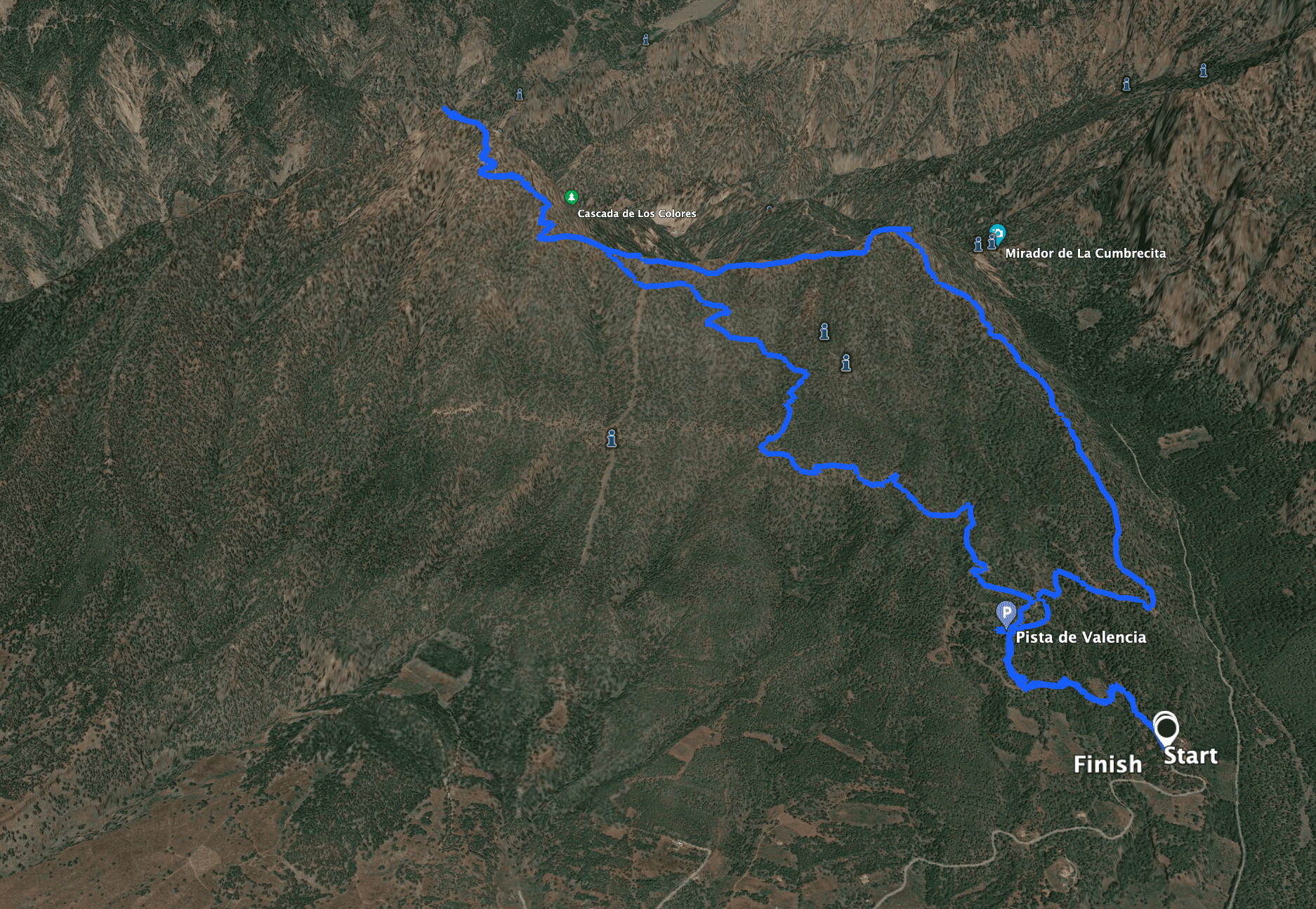
Track of the hike to Pico Bejenado
General information about the Pico Bejenado hike
Starting point and approach
The starting point of the hike is the Pista de Valencia LP-302 via El Paso. GPS data: 28.675323, -17.848621.
Arrival by car
Take the LP-3 and turn off at the visitor centre. Then you pass the visitor centre and follow the road LP-302 uphill. I stopped at the point where the asphalt road turns into a dirt road. There is also a big sign that this is a taxi call point.
Arrival with bus
You can get to El Paso near the visitor centre by taking bus number 300, which runs along the main road LP-3. See the Tilp homepage for details. From there you can take a taxi to the starting point or walk another 6 kilometres. Time
Article summary and large selection of GPS hiking tracks
Sign up for my newsletter now and get exclusive access to my collected GPS tracks as well as all the brief information about my articles.
Sign up nowII don’t like to give general times for hiking tours, because the times are very individual. We needed about 5 hours and 15 minutes for this hike with an extensive rest at the summit.
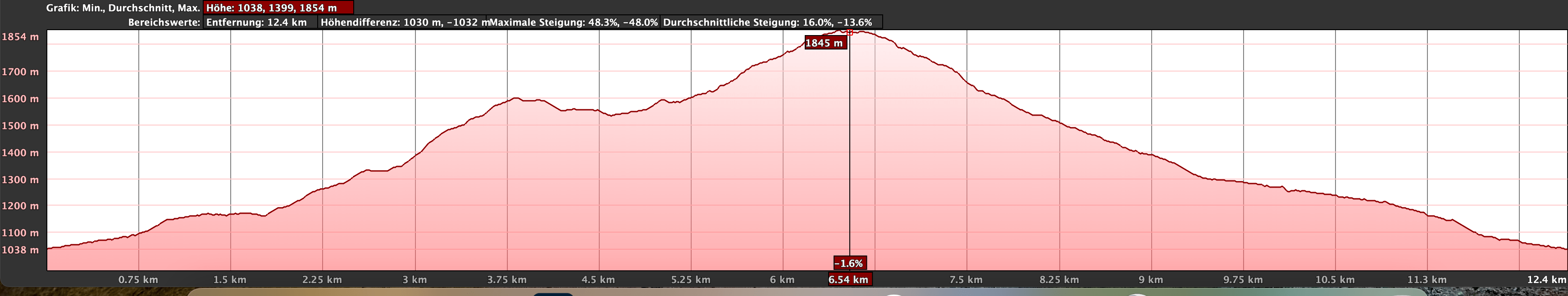
Altitude profile of the hike to Pico Bejenado
Altitude difference and route length
The difference in altitude is about 900 metres and the route is about 15 kilometres long.
Requirement
Basically, this is a simple and easy hike on good paths. However, because of the length and the metres in altitude, you should be in good physical condition.
Refreshment
There are no restaurants, bars or shops along the entire route. Therefore, take enough water and food with you if necessary.
Variants
This tour can be easily combined with various other hikes and circular walks in the vicinity. The length can be shortened considerably if you continue up the slope in a vehicle suitable for the slope. Also, if you only want to go up Pico Bejenado, you can avoid the steep climb up Roque de los Cuervos. In case you don’t take the circular route, but only the return route via the Pista Valencia described here, you will save a few kilometres as well as metres in altitude.
And if you want to extend the tour, you can do it from Cumbrecita via Roque de los Cuervos. If you only hike from the Cumbrecita to Pico Bejenado and back, you save a few metres in altitude, as you start at 1305 metres. The path from the Cumbrecita up to the Roque de los Cuervos is not as well-maintained as the other hiking paths of the circular tour described here. In fact, you have to reckon with narrow and quite sloping paths in places.
Furthermore, it is possible to start the hike directly at the visitor centre in El paso for a really long tour.
If you would like to visit the petroglyph site at Lomo Estrecho, you can also extend the way back in this way.

Hike on the ridge path along the Cumbre to Pico Bejenado
Hike to the Pico Bejenado
Track section Pista Valencia to end of track
You start the hike at the end of the asphalt road Pista de Valencia LP-302 via El Paso (GPS data: 28.675323, -17.848621) at the taxi call sign. From there, hike uphill on the wide Pista de Valencia forest road for quite a while. Finally, there is a possibility to shorten a very long loop of the Pista by following a small path on the right up the mountain. You can see how we walked in the picture and on the track.

Starting point hike Pico Bejenado
If you want to save yourself further metres in altitude, you can possibly drive up to here with a car suitable for the forest road. You come out at the Pista Valencia and a large national park board (information). You will come down here on the return hike from the top. But now you continue to the right on the Pista Valencia. This leads you around the slope in a few bends for a short time and then ends in a narrow path.
Article summary and large selection of GPS hiking tracks
Sign up for my newsletter now and get exclusive access to my collected GPS tracks as well as all the brief information about my articles.
Sign up now
Wall in the forest at the end of the Pista de Valencia - Barranco crossing
Route section end of Pista Valencia to Roque de los Cuervos
On a narrow path you cross a small barranco with a wall. Go past it on the left. Follow the narrow path through the bottom of the barranco and uphill again on the other side. At the top you will come to a track. Follow this to the right. After a short while, a path marked with a green sign leads from the track to the left up to the Bejenado above the Roque de los Cuervos. From the beginning, this small path leads you steeply up a ridge. From time to time the path goes straight over the ridge and then again in small steep serpentines. But you always have fantastic views back and to the right.

Start of the steep path to Pico Bejenado via Roque de los Cuervos
On this section you gain almost 500 metres in altitude. But in the end you will arrive at the top of the ridge at the edge of the cliff. Here you can look down from the Roque de los Cuervos to the Cumbrecita and into the wide Barranco Angustias as well as onto the rock faces opposite. This is a good place to take a rest. If you have taken the path from the Cumbrecita up here, you will pretty much come out here at Roque de los Cuervos. The rest of the way is identical up to Roque Bejenado.

Hiking uphill on a green ridge trail through the forest
Route section Roque de los Cuervos to Pico Bejenado
From Roque de los Cuervos, the trail leads you up and down along the ridge. In front of you, you can already see the impressive Roque Bejenado. And down you look at the Mirador Lomo de las Chozas and the caldera. After a while, a path descends to the left. It is excellent for a petroglyph site at Lomo Estrecho. This path will also lead you to the way back described here. If you want to see the petroglyphs, you can return here after climbing Bejenado and take this path as your way back.

View of the Cumbrecita from Roque de los Cuervos
But now you continue straight ahead along the ridge. You are getting closer and closer to Pico Bejenado. Finally, you will reach a place where your way back branches off to the left downhill from the path. To climb Pico Bejenado, continue straight ahead. Then the actual ascent begins, which is now a little steeper again. Wonderful views in all directions await you on the beautiful ascent path. Then it’s done and you have reached the summit of Pico Bejenado.

View of the caldera and the Cumbrecita from the ascent path Bejenado
Route section Pico Bejenado to starting point car park
Nachdem After enjoying the magnificent view at the summit, you can walk a little further. A small path on the left side of the summit leads to a viewpoint in front of the summit. From here you have an impressive panoramic view. Then take the same path back down Pico Bejenado. When you reach the foot of the mountain and return to your outward route, this time turn right and walk downhill. The trail is well marked and leads you steadily downhill through some small ravines. After a while, you will meet the path on the left that leads up to the petroglyphs.

Hiker on the summit of Pico Bejenadao
You hike over a wide ridge straight downhill. Several times you pass through the forest over small ravines. Finally, the path widens and becomes a track. Then you reach the Pista de Valencia. You started your hike on the left. Now follow the track to the right. Or, like me, go downhill on a small path to shorten the track a little. Once you are back on the Pista de Valencia, it is not far to the starting point where your vehicle is waiting for you.

Forest track (way back) from Pico Bejenado
And finally
I hope you enjoyed this hike through the green forests of La Palma to Pico Bejenado. This beautiful hike with wonderful views can be done in many different ways. You will find the right hike for you. I wish you much joy on all your paths,
Dagmar from Siebeninseln