Ruta del Agua – Interesting facts about water
On this 8-kilometre hike, as the name Ruta del Agua suggests, you will learn a lot about water and water extraction on Tenerife and in La Guancha. On many different walks that I have published on Seven Islands, I have already told you a lot about water extraction on Tenerife through galleries (tunnels driven into the mountains). So you know (at least as a reader of Seven Islands) that in some places you can also walk through these tunnels and over water channels.
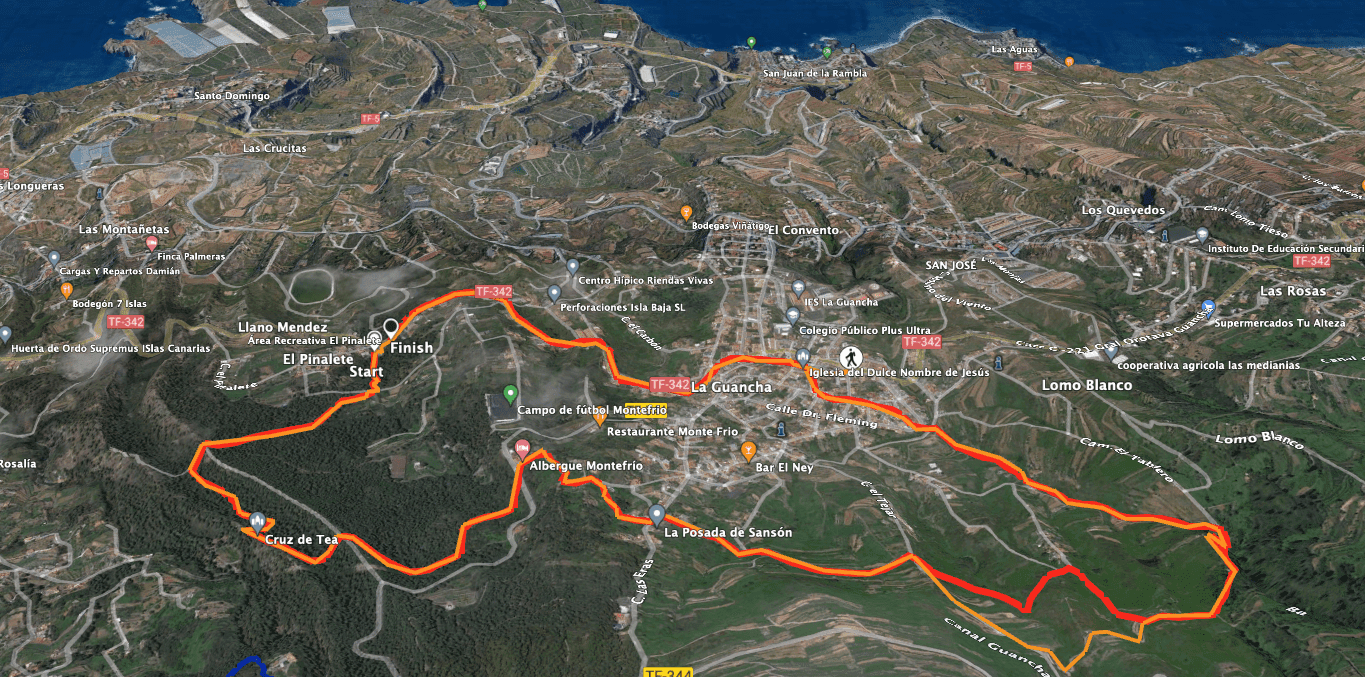
Map

Starting point of the hike - El Pinalete
Today’s hike, on the other hand, is very moderate. A leisurely round to enjoy with lots of interesting information. The Ruta del Agua leads you from the Galería El Pinalete in a large circular walk around La Guancha past many interesting places that have to do with water extraction. You will pass galleries, closed tunnels, open and covered water channels. Because the hiking tour is well signposted, you will also learn a lot of interesting facts about water extraction.

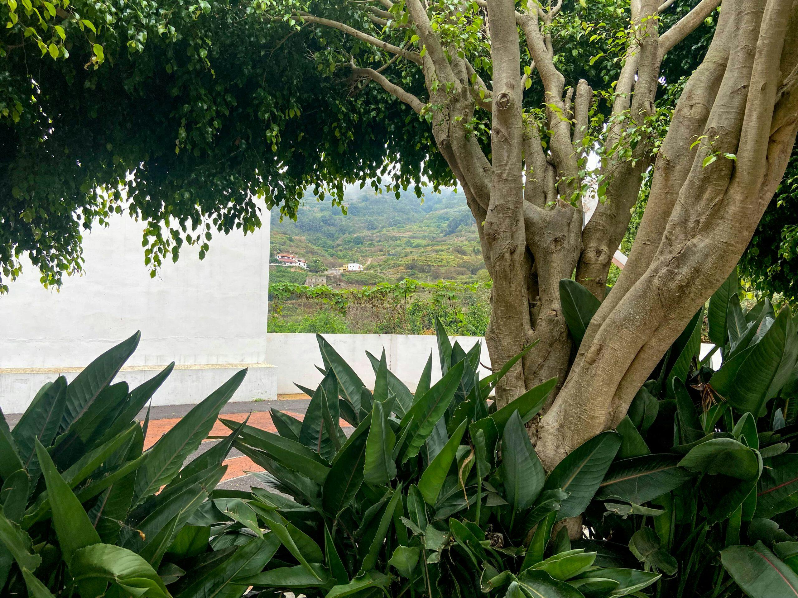
View over La Guancha
Ruta del Agua – Hiking around La Guancha
But regardless of the diverse information about the water in La Guancha, which covers 7% of Tenerife’s water supply, this round on the Ruta del Agua around La Guancha offers you a lot more. You walk through a varied landscape such as pine forest, fields, gardens, small ravines and also through the small colourful village itself. If you hike at the right time, you can pick figs, almonds or blackberries along the way. In any case, you should combine your tour around La Guancha with a visit to the nice little village.

Ruta del Agua hiking trail
It lies at an altitude of 500 metres and takes its name from a pretty indigenous woman (the Guanches, the Guanchin, La Guancha). Today’s inhabitants, whose forests no longer extend down to the coast as they once did, live mainly from agriculture and small-scale industry. You can get a first impression of the town on the circular walk, which starts in the district of El Pinalete in La Guancha and later leads you back through the town to the starting point.
Track La Guancha - Ruta del Agua
General information about the Ruta del Agua round trip
Starting point and approach
Starting point of the hike the district of El Pinalete in La Guancha at the rest and picnic area of the same name on the TF-342.

Starting point Ruta del Agua - El Pinalete
Arrival by car
From the north or south, take the TF-5 and then head towards La Guancha. There you will easily meet the TF-342, as it is the main road of the village. It also leads past the starting point of El Pinalete. This rest area, like the entire Ruta del Agua, is also well signposted. There are many parking spaces at the El Pinalete rest area.
Arrival by bus
The Titsa bus line 354 stops not only in La Guancha, but also at the starting point El Pinalete. Details and more information can be found on the Titsa homepage. Time
I don’t like to give general times for hiking tours, as the times are very individual. I needed just under 2.5 hours for this short circular walk and still studied the landscape and the information boards in detail.
Article summary and large selection of GPS hiking tracks
Sign up for my newsletter now and get exclusive access to my collected GPS tracks as well as all the brief information about my articles.
Sign up now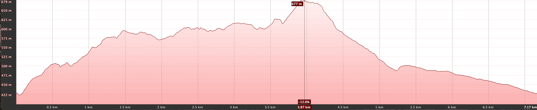
Elevation profile of the Ruta del Agua hike
Altitude difference and route length
The difference in altitude is about 350 metres and the route is just under 8 kilometres long.
Requirement
This hike can be described as easy. It leads you mostly on well-marked hiking, driving or road paths. Only some descents are on narrower paths.
Refreshment stops
Restaurants, bars and shops in La Guancha.
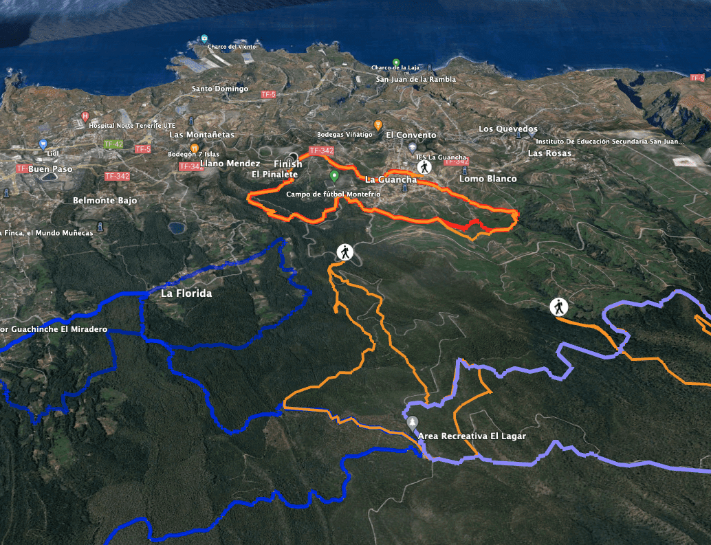
Track Ruta del Agua and neighbouring tracks
Variantes
You can combine this loop with many other hiking tours around La Guancha. At the moment (September 2022), however, many tours above La Guancha are still closed due to the forest fires that recently affected the region. In the immediate vicinity of this loop, you will also find the circular hike La Florida and the Cueva del Viento. 
View of La Guancha
Round tour Ruta del Agua
Route section El Pinalete rest area to Cruz de Tea
On the other side, the trail continues through the pine forest. You walk for a long time through the dense pine forest, often along water channels that you cross from time to time. You walk through a wide valley and finally climb up the right side of the slope to the Cruz de Tea. This Cruz de Tea has nothing to do with the place of the same name on the east side of the island, from which I have already described hikes. At Cruz de Tea near La Guancha you will find the small Ermita Cruz del Chacho. 
Ruta del Agua hiking trail along water channels
You start your hike at the rest and picnic area El Pinalete. Here you will find the first information about the Ruta del Agua, the Galería El Pinalete and the water supply on Tenerife. There is also the small Ermita San Antonio de Padua, rest and picnic areas and a restaurant. You can take a close look at everything before and after the hike. For the Ruta del Agua, however, you go past the restaurant and follow the signposted hiking trail that leads straight into the pine forest. You walk uphill for a while on a beautiful path in the pine forest. Then you reach a road, which you cross.

Ermita Cruz del Chacho - Cruz de Tea
Section Cruz de Tea to Calle las Eras
From Cruz de Tea, continue downhill through the pine forest on the slope side, cross the valley and up on the other side. Cross a wide road and continue through the pine forest on the other side. Through the forest, the trail later runs parallel to the TF-344. Finally, the trail joins the TF-344 at the Albergue Montefrio. Cross the road and follow the small street Calle Hoya Gris.

Sendero Ruta del Agua - Albergue Montefrio
Article summary and large selection of GPS hiking tracks
Sign up for my newsletter now and get exclusive access to my collected GPS tracks as well as all the brief information about my articles.
Sign up nowThis takes you past fields, meadows and individual farmsteads with beautiful views of the village of La Guancha below. Shortly after a finca, you leave the steeply descending road on a narrow and hard-to-find hiking trail. Look carefully, the hiking trail is marked with a white-yellow arrow. The small path leads you along water channels through green fields, meadows and scrubland. It ends at a house, which you pass on the right on a small road. The small road leads into Calle las Eras.
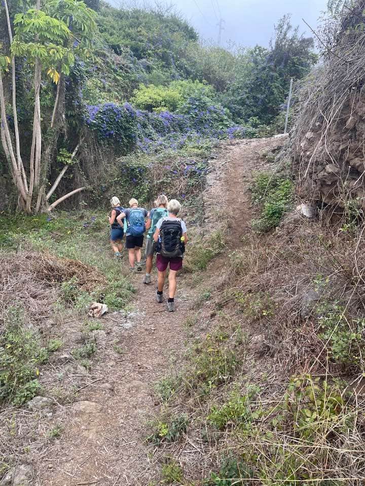
Ruta del Agua hiking group
Section Calle las Eras to the junction of the roadway
You go left downhill on Calle las Eras, but after a few metres turn right into a small street that first takes you past some houses. Then it turns into a small path. From here you also have beautiful views of the coast and even the Anaga Mountains. Finally, the path meets another small road, Calle la Burgaya. Follow it around to the right and uphill for a while.

Hiking trail over La Guancha with Teide view
When the small road meets Calle el Tejar, you have two options. I have tried both. And both are about the same length. One option is to follow the road up a little further and then take the first wide dirt track on the left. This leads you on a wide path through and over the Barranco de los Palomos. The second option is a little more exciting. Immediately when you reach Calle el Tejar, the hiking trail leads down to the left, taking you on narrow paths across the Barranco de Palomos.

Water features such as Galería los Palomos give the trail its name, Ruta del Agua, and you'll find plenty of them along the way.
Only on this path will you pass the Galería los Palomos. A beautiful little path and highly recommended. Once you have left Barranco los Palomos on the other side (Hoya el Mocán), take a somewhat steep path uphill to the right. This leads into a road. And at this point, both options converge again. With the first option, you just go straight on. And with the second option, turn left onto the road.

Galería Derriscadero
Section of road junction to farmsteads
On this road you hike straight ahead for quite a while with the best views. You will go slightly downhill and uphill again to cross another gorge. Then you will find yourself on a ridge. You follow the ridge path, which eventually turns into a descent. At the bottom, you will find yourself on the Camino de Tablero. Follow it around to the right for a short while. Immediately you will pass the next Galería Derriscadero.

Galería Derriscadero
The tunnel is closed, but there is always something to see around the old galleries. Immediately afterwards, the trail turns left on a small path into the Barranco de Don Bruno. Here you walk again on small paths through lots of greenery, fruit trees and bushes. Finally, you reach the first farmsteads. The path continues downhill through the farmsteads.

Hiking trail near La Guancha - Ruta del Agua
Route section farmsteads to starting point El Pinalete
Continue along the small hiking trail that takes you steeply downhill over stones towards La Guancha. In La Guancha, the Ruta del Agua brings you to Calle El Pino, which you cross. Go up a path and you will reach a square. Turn right immediately onto Calle Asomada. This will give you a glimpse of the centre of La Guancha. After a while, turn right off Calle Asomada, reach the church square and walk past the church onto Calle la Alhóndiga. After a short while you will reach the main road TF-342, which you follow around to the left.

Small church in La Guancha
Even though you will be walking along a busy road for a while, you will have beautiful views to the right over the lower part of La Guancha to the coast. And you get to see a bit of life in La Guancha. If you don’t want to hike here, you can also take the bus that runs along this stretch to the starting point of El Pinalete. Whether by bus or on foot, you can return to the starting point of El Pinalete. There will certainly be time to get detailed information about the Ruta del Agua.

Street painting in La Guancha
And finally
I hope you enjoyed this short hike around La Guancha. It does not offer the high challenges for fit hikers, but a lot of variety and interesting information about the Ruta del Agua and the water on Tenerife. I hope you enjoy all your hikes,
Dagmar from Siebeninseln.