Montaña de La Cruz de Tea and Cuevas Negras
Map
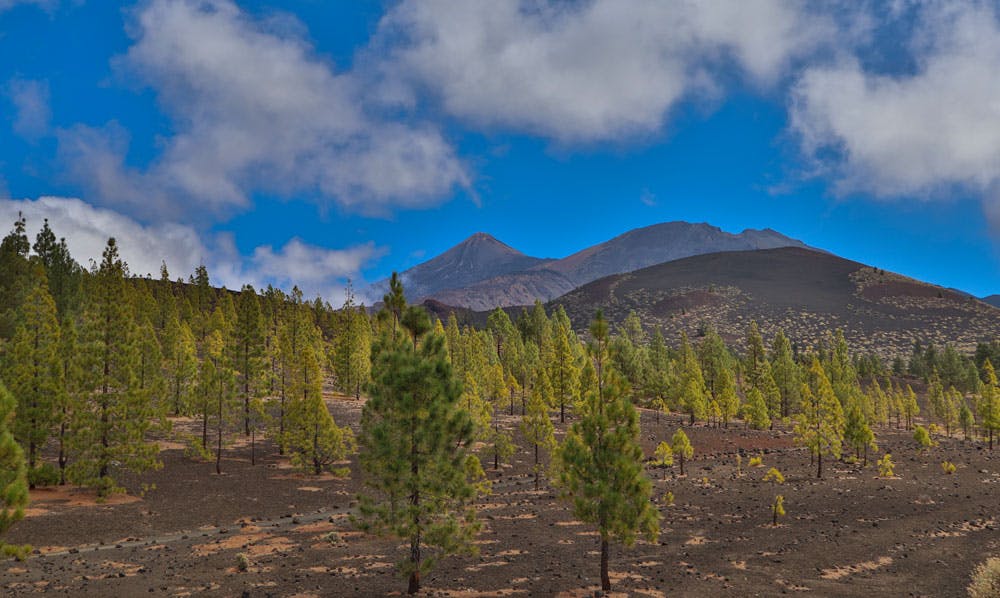
Today’s circular walk around the Montaña de La Cruz de Tea takes you once again to the region below the mighty Teide. The volcano Montaña de La Cruz de Tea is 2212 meters high. And the entire circular walk will take you around the Montaña de La Cruz de Tea.

Montaña de La Cruz de Tea - hiking path
Directly above you is the mighty Pico Viejo and behind it the Teide. Since the hike starts at the same place as the hike around the Montaña Samara and the Montaña Botija, you can also combine these two tours. 
here you will find the cuevas negras
Also on this tour you will see Cuevas Negras (Black Caves) again. On a volcanic island, where there are many lava tubes and thus also caves and collapsed caves, you will encounter this phenomenon again and again. However, when Tenerife speaks of the Cuevas Negras, we generally mean the Black Caves and the abandoned hamlet between Erjos and Los Silos. This tour can be found here or combined with a walk through a water tunnel here. 
Panorama - circular Montaña de La Cruz de Tea
As you walk around the Montaña de La Cruz de Tea, you will come across black volcanic plates to the left and right of the trail. Below them are the volcanic tubes and the dark caves (Cuevas Negras). At some of the volcano tubes the ceiling has collapsed so that you can have a look inside the black caves. But the biggest and most famous volcano tube of the island Tenerife (and even Europe) is the Cueva del Viento at Icod de los Vinos. 
Track circular hike Montaña de La Cruz de Tea
General information about the circular walk around the Montaña de La Cruz de Tea
Starting point and approach
The tour around the Montaña de La Cruz de Tea starts at the parking lot at the TF-38 (between Chío and Boca Tauce) at km 7.7.

Starting point parking - Montaña de La Cruz de Tea
Arrival by car
If you are coming from the south of Tenerife or from the north on the TF-1 motorway, take the Guía de Isora or Chío exits. Then take the TF-38 towards Teide National Park. Those who come from the centre of the island via the Cañadas road TF-38 drive in the direction of Chío or Santiago del Teide. As the starting point is a parking place, parking places are of course available directly at the starting point of the hike. But if you arrive late in the day, there may be a shortage of parking spaces.
Arrival by bus
Unfortunately, it is not possible to get to the starting point by bus, as there is no Titsa bus that drives this route.
Article summary and large selection of GPS hiking tracks
Sign up for my newsletter now and get exclusive access to my collected GPS tracks as well as all the brief information about my articles.
Sign up nowTime

junction hiking trails - Montaña de La Cruz de Tea
I don’t like to give general time information for hiking tours, as the times are very individual. And also I need for each tour sometimes more and sometimes a little less time. For this round we needed about 3 hours with an extensive picnic. If you hike fast without taking a long break, you can also do this little tour in half the time.

elevation profile Montaña de La Cruz de Tea
Difference in altitude and distance
The difference in altitude is about 380 meters. The route is just over 8 kilometres long.
Requirement
An easy tour that can be easily mastered by anyone with a little physical condition. The paths are wide and mostly well signposted.
Refreshment
There are no places to stop for refreshments. Therefore it is absolutely necessary to take enough water and food with you.
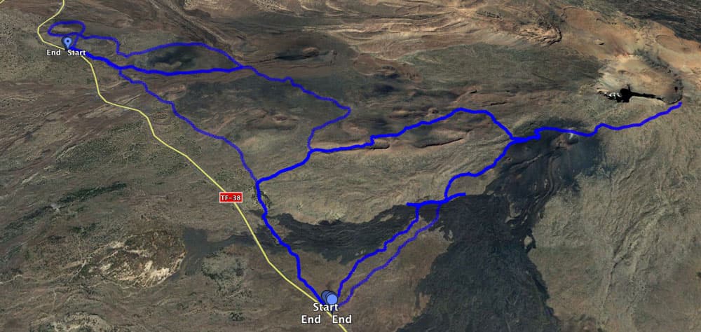
Track circular Montaña de La Cruz de Tea and Montaña Samara and Pico Viejo
Variants
The round trip can be combined well with various other hiking tours in the vicinity. It is identical on one section with the circular hike around the Montaña Samara. On the other hand, a short stretch is identical to the tour to the Pico Viejo. Therefore you can extend this little round trip to the Pico Viejo or even from there to the Teide. 
view on Mount Teide, Pico Viejo and pine woods
Hike around the Montaña de La Cruz de Tea
Section car park to fork S-38/S-13
You start your walk around the Montaña de La Cruz de Tea at the parking lot described above. At the same place you start the hike around the Montaña Samara and the Montaña Botija. During this hike, go straight ahead and come back on the path that leads from the right to the parking lot. Today, however, turn right immediately onto the S-38/S-13 sign. At first you walk a little parallel to the road. But then the path turns left up the hill. Already after a short time of ascent you reach a fork. On the right you will return later on the hiking trail S-32 /Wandertafel with the name Abeque. But now keep left on the S-38/S-13.

view on the islands of La Gomera and El Hierro
You started at an altitude of 1850 meters. The path now takes you up steeply. Quickly the road and the parking lot remain far below you. If it is not cloudy, you can already enjoy a wonderful view of the south coast and the neighbouring islands La Palma and La Gomera. On particularly clear days even El Hierro appears on the left behind La Gomera. After some time of steep ascent you come back to a fork. Here you will find a hiking board and path names, which are fixed on a stone. Now S-38 and S-13 separate. On the left the S-38 continues with the round tour around the Montaña Samara. However, you continue straight ahead with the S-13.
Article summary and large selection of GPS hiking tracks
Sign up for my newsletter now and get exclusive access to my collected GPS tracks as well as all the brief information about my articles.
Sign up now
Montaña de La Cruz de Tea and in the background Pico Viejo
Follow the road forking S-38/S-13 to the highest point of the hike via Montaña de La Cruz de Tea.
So you continue straight ahead, leaving behind you the impressive Montaña de Botija you just passed. After a short time, a path crosses a small lava flow and descends to the right. You walk on this small path down to a kind of plain. Now the Old Teide, the Pico Viejo lies majestically in front of you. The path is well marked and not to be missed. It continues slightly uphill.

bushes, pines and volcanos -Montaña de La Cruz de Tea
After some time you will come across large „black stone piles“ to the left and right of the path. As you approach, you will see that these are collapsed volcanic tubes. These are the black caves (Cuevas Negras). One is on the right, but most of them – as far as I could see – on the left of the path. You are now almost at 2250 m altitude and thus at about the same height as the Montaña de La Cruz de Tea (2212 m altitude), which is now to your right. Here is the highest point of the hike. From now on you will hike almost only downhill.

junction in the little pine wood
The highest point over Montaña de La Cruz de Tea – fork S-9/S-13
The path now leads you slowly downhill again. You walk between bushes and rocks and can enjoy the view of the coast and the neighbouring islands. To your right is the Montaña de La Cruz de Tea and to your left the Montaña de Chio (2345 m). Then you come again to a fork. On the left uphill you go with the S-9 to the Pico Viejo or even further on the Teide. This section is part of the hike up to Pico Viejo. However, you keep going down with the S-13. 
hiking trail close to the Cuevas Negras
The path leads downhill in small serpentines. Later you will pass a fenced test field. After a long time of descent you reach a small forest area with pine trees. Here again you have a fork in the road. Turn left and take the S-9 to the starting point of the hike to Pico Viejo. However, you continue with the hiking trail S-38/S-13 on the right through the forest area.

Hiking path over lava - in the background La Gomera
Section of road S-9/S-13 to the starting point Parking lot
For a short time the path continues through the pine forest. During the hot seasons this is the perfect resting place in the shade. When you come out of the wood you go up and parallel to the road. At another fork in the road, keep left. It goes on a well recognizable path over volcanic rock. On the left there is a small white chapel rich in contrast in the dark lava rock.

Hikers on serpentine paths
You keep going straight on for a while as you hike south of the Montaña de La Cruz de Tea. After about 2 more kilometres you reach the fork, where you hiked left uphill on the way there. Now it goes left downhill. On the pretty path, partly covered with pine trees, on which you also came, you return to the starting point, the car park, in a short time.

little chapel close to the hiking path
And at the end
I hope you enjoyed this little hike. And if it is too short or too easy for you, combine it with the walks around the Montaña Samara and the Montaña de Botija. If you are very fit, it is a good idea to combine this small volcanic tour with the ascent to Pico Viejo. Whatever you choose, I wish you beautiful and safe walks,
Dagmar von SiebenInseln