Tenerife Samara – Hiking between volcanoes
Map
Today’s hike on Tenerife around mount Samara is once again a small hike that is suitable for everyone. In a leisurely round trip, you will go on an impressive tour over and between volcanoes at an altitude of approx. 2000 metres below the Teide.

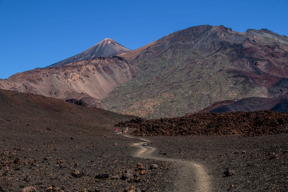
Samara circular - view on the Teide, Pico Viejo and Montaña de la Botija
If the 2 hours long tour is not enough for you, there are still some good additional routes and variants. But no matter what you choose, good views in all directions are guaranteed.

Canary pine with long pine needles
Water extraction and pine forests on Tenerife
In other articles I had already mentioned the so-called Galerias, tunnels that were driven into the mountains on Tenerife for water extraction. But also a tree helps with the water extraction on some Canary Islands. When hiking between 700 and 2000 altitude meters you will meet on Tenerife and the other Canary Islands mainly a tree species. And this is the Canarian pine. If you do the Samara hike, you will also see the Canary pine standing all along the way in this area.
The Canary pine belongs to the pine genus and is endemic to the Canary Islands (except Lanzarote and Fuerteventura). It is only found in Tenerife, Gran Canaria, La Palma, El Hierro and La Gomera. No wonder that it is also the most important tree species of the Canary Islands economically and even a natural symbol of the island of La Palma. The pines grow to an average height of 15-25 metres. In individual cases, however, individual specimens with a height of more than 50 metres are said to have been sighted on Tenerife.

Samara circular -Serpentine hiking trails at the edge of the pine forest
Canary pine – resistant with long roots and long needles
The life span of the Canarian pine is considerable and lies between 250-300 years. The pine is very resistant and sprouts quickly even after forest fires. Therefore, on the five Canary Islands mentioned above, there are many forests with black charred tree trunks caused by forest fires, but fresh coniferous greenery. The Canarian pine is characterized by particularly long roots. These protect them from „falling over“ during major storms and make it easier to absorb water from deeper soil layers.
Also the long needles help with the water admission and conservation from the air and the passing clouds. The pines prefer to stand on the northern slopes of the islands. There they are exposed to the cloudy trade winds. With their up to 30 cm long needles they get the water from the trade wind clouds. The condensed water then drips off from the needles as precipitation. Thus the trees actually help with the „irrigation“ of the islands.

Track circular hike Samara
General information about the Samara circular hike
Starting point and approach
The tour starts at the parking lot on TF-38 (between Chío and Boca Tauce) at km 7.7.
Arrival by car

Parking lot and tourstart circular hike Samara
If you are coming from the south of Tenerife or from the north on the TF-1 motorway, take the Guía de Isora or Chío exits. Then take the TF-38 towards Teide National Park. Those who come from the centre of the island via the Cañadas road TF-38 drive in the direction of Chío or Santiago del Teide. As the starting point is a parking place, parking places are of course available directly at the starting point of the hike :-).
Arrival by bus
Article summary and large selection of GPS hiking tracks
Sign up for my newsletter now and get exclusive access to my collected GPS tracks as well as all the brief information about my articles.
Sign up nowYou cannot get to the starting point by bus, as there is no Titsa bus that runs this route.
Time
I don’t like to give general time information for hiking tours, as the times are very individual. Hiking should bring recreation and fun. And also I need for each tour sometimes more and sometimes a little less time. For this hike I would plan with ascent to the Montaña Samara a comfortable 2 hours. On the hiking sign at the entrance of the route 2.5 hours are estimated. For route extensions and the variants you need of course correspondingly more.

elevation profile Montaña Samara

elevation profile Montaña Samara and Montaña Botija
Difference in altitude and route length
The difference in altitude is about 280 meters and a little more gross. The course is a good 5 kilometres long.

Hiking board with elevation profile Montaña Samara
Requirement
An easy and for everyone with a bit of fitness easy to master tour. The paths are wide and mostly well signposted. Only on the way there two somewhat steeper climbs to the volcanoes.

information board by the wayside
Refreshment
No stop for refreshments. Therefore take enough water and food with you. The first stop for refreshments is the large Estrella rest stop at about 22 km of the TF-38. Small tip: Coffee is not exactly the highlight there. Therefore it is better to drive 8 kilometres further down to Chio and look for a nice little bar there. There is enough.
Variants Samara hike
This tour can be done as a round tour in both directions. If you want to climb the summits of the Montaña Samara and additionally the side summit of the Montaña de la Botija, you can also decide on the tour.

hiking tour 13 leads to Montaña Samara
The round tour can also be combined well with various other hiking tours in the vicinity. There is, for example, a small extension route (hiking trail no. 38) that branches off from the circular trail well signposted at the top under the summit of the Montaña de la Botija. This tour lasts about 1.5 hours, is over 100 metres in altitude and is two kilometres long.
on information boards you will find other variants to hike around
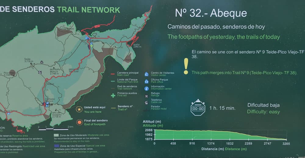
Another tour is the junction hiking trail number 38 Abeque, which leads over 200 altitude meters and three kilometers per route (official time 1 hour 15 minutes per tour) further up.
It is also possible to go to the Cuevas Negras or the adjoining round to the Montaña de La Cruz de Tea via a branching hiking trail. The Pico Viejo can also be reached here (demanding). In the southwest the hike follows to the Montaña de las Corredera. 
View from Montaña Samara to the Teide region
Hike to the volcano Samara and the Montaña de la Botija
Parking up to the volcano Montaña Samara
Article summary and large selection of GPS hiking tracks
Sign up for my newsletter now and get exclusive access to my collected GPS tracks as well as all the brief information about my articles.
Sign up nowThe small hike on Tenerife at high altitude doesn’t really require too much description, as the hiking path no. 13 is very well signposted and the paths are often marked with stones on the sides. You can do the tour to the right or to the left. I prefer to start the hike on the left towards the volcano Samara. So you can master the first small ascent to the volcano Samara right at the beginning of the hike. After passing the signposts, the path leads you straight ahead in the direction of Samara.

Panorama view from top of mount Samara
You climb up to a small hill and can then climb on a narrow path on the left over the ridge about 100 height meters to the edge of the volcano. From there you have the first beautiful view back to the paths below you around the volcanoes. Straight ahead you can see the Teide and the Pico Viejo in a cloudless sky. To the west you can see the Teno Mountains and in the distance you can see the neighbouring island La Gomera. You can continue hiking on the volcano edge to the summit of Montaña Samara. Since it is steep downhill on both sides, this route should be avoided during storms.

Hiking path to Montaña Samara
Route section volcano Montaña Samara – Montaña de la Botija
When you have seen enough of the first volcano, you go downhill again and go straight on along the way. If you don’t want to do the small ascent, you can of course walk around to the right. From now on the hiking path, which is bordered with stone rows, will bring you up slowly. After some time you will reach a crossroads. To your right you will now see the path on which you will come back. But you go sharp left.

uphill on narrow pathes
Then the steeper ascent begins through the flank of the Montaña de la Botija. At dry times you will see many dry plants and bushes around you. Only survivors seem to be the Canary Islands pines on this black volcanic slag soil, which will accompany you uphill for a while. Then it goes only on a black volcanic scree path further steeply uphill towards the summit of the Montaña de la Botija. This is the steepest part of the hike. Once you have survived it, you only have to go slightly uphill and then downhill again.
Section around the Montaña de la Botija and junction to the Montaña Reventada
Climbing the summit of the Montaña de la Botija (2122 m) itself is forbidden. But there is a clearly visible steep path leading up to the secondary summit (2114 metres above sea level). Those who want to enjoy the wonderful view from up there and want to hike a little higher should do so. Otherwise it goes now in a wide arc on a narrow lava path along the edge of the Montaña de la Botija. To your left the black lava flow that has flowed down from the Montaña Reventada. And in front of you you see the Teide and the Pico Viejo.

Hiking trail over lava slag
It goes a little downhill, then slightly uphill again. Now you are at the highest point of the circular hike and may want to take a rest at the top. To the left there is a signposted path with number 38 in the direction of Cuevas Negras. If you want to extend the route a little, you can follow a „nature trail“, where you can see many different volcanic rocks. The path marked Cuevas Negras leads southwest past the Montaña Reventada. Each way is two kilometres long and it takes 1.5 hours extra.

Volcanic landscape around Montaña Botija
Route section Montaña de la Botija – crossroads junction hiking trail Abeque
If you don’t want to go enlargement, turn sharp right. The path continues along the lava sand ridge with wonderful views. To your left is a large lava field. Slowly the path starts to descend again. It goes more times and then again gently downhill in the black „volcano worlds“. If you have very good weather, now all western neighbouring islands of Tenerife, namely La Gomera, El Hierro and La Palma, lie in front of you.
In wide hairpin bends it goes downhill now. The first pines appear and the path becomes sandier. Further down you come to the well signposted hiking trail number 32, which branches off to the left of the round tour. In a good three kilometres you will climb over 200 metres to Abeque. The official time is indicated on the big hiking board with 1 hour 15 minutes per distance. Thus, also here, it is an opportunity for a further excursion. And who then still does not have enough: The hiking path 32 leads into the hiking path to the old Teide – Pico Viejo (a real challenge).

hiking way back through the pine forest
Section of the crossroads Hiking trail number 32 – car park
From now on it goes very leisurely through pines and downhill on good paths. One more time the path forks. You continue straight ahead. On the left side you pass a „rain gauge“. Then it goes parallel to the road for a while. And then after about 2 hours – if you haven’t walked any additional tracks – you’ll be back at the parking lot.

view from the height to the Teno mountains and the island of La Gomera
Finally
Also today I presented a small hiking tour on Tenerife, which every hiker can do well. I wish you a lot of fun hiking and a day without clouds, so that you can enjoy the fantastic view.
Dagmar von SiebenInseln