Tenerife circular walks in the Parque Nacional de Corona Forestal
Today there are two circular walks in Tenerife. These take you to the Parque Nacional de Corona Forestal. The unique nature reserve forms a very large „extension ring“ around the Teide National Park.
Map

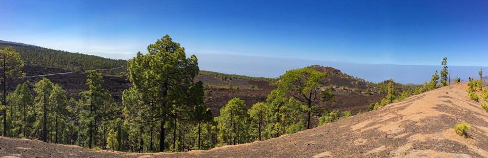
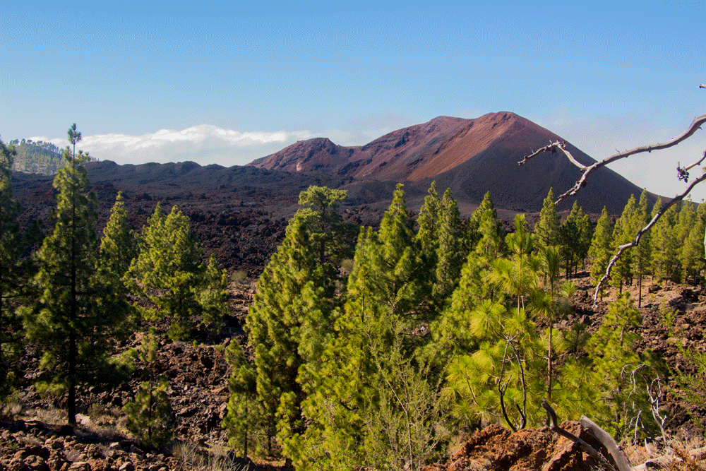
View on Mount Teide and Pico Viejo
It has a total area of 41,067.7 hectares and is thus the largest nature reserve of the Canary Islands. It extends from 300 metres above sea level to a height of 2718 metres in the Alto de Guajara.

Tenerife circular walks through the pine wood
Most of the nature reserve consists of forest. In the northwest it borders on the nature reserve Chinyero and in the northeast on the protected landscapes La Resbala and Las Lagunetas. In the southern foothills it borders on the special nature reserve Barranco del Infierno as well as the protected landscapes around the Barranco del Erques and Ifonche. 
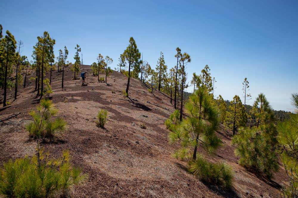
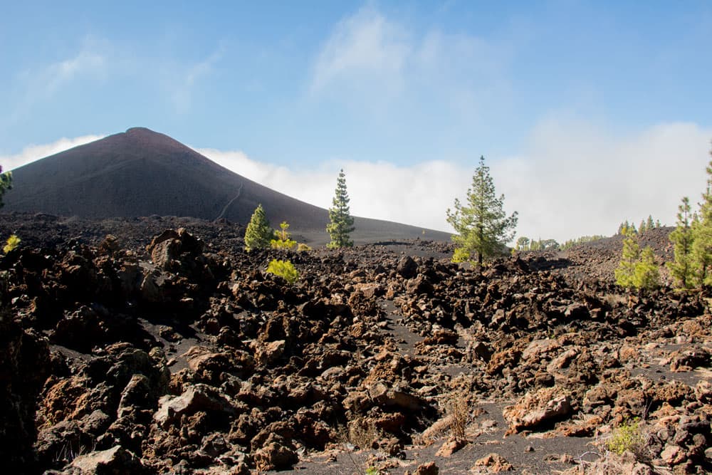
steep slope at the Montaña de las Cuevitas
On the Montaña de las Cuevitas and around the Montaña la Corredera – 2 Tenerife circular walks
Since both Tenerife circular walks lie next to each other, they are now available in a double pack. Both start at the TF-38. The first circular hike goes on the Montaña de las Cuevitas. And then the second circular hike, which starts near the Chinyero, borders the Chinyero circular hike and the circular hike to the Montaña de las Cuevitas. The hiking track goes with some corners and edges around the Montaña la Corredera. 
Starting point - country lane to Montaña de las Cuevitas
While the adjacent Tenerife circular hikes around the Montaña Samara and around the Chinyero volcano are described in almost every hiking guide, today’s two tours are rather „lonely“ rounds on which you will probably meet only a few other hikers. Since the route description is very difficult with today’s Tenerife round hikes, I recommend in any case to go these tours with JPS Track, which you can download free of charge from me.

Track Montaña de las Cuevitas
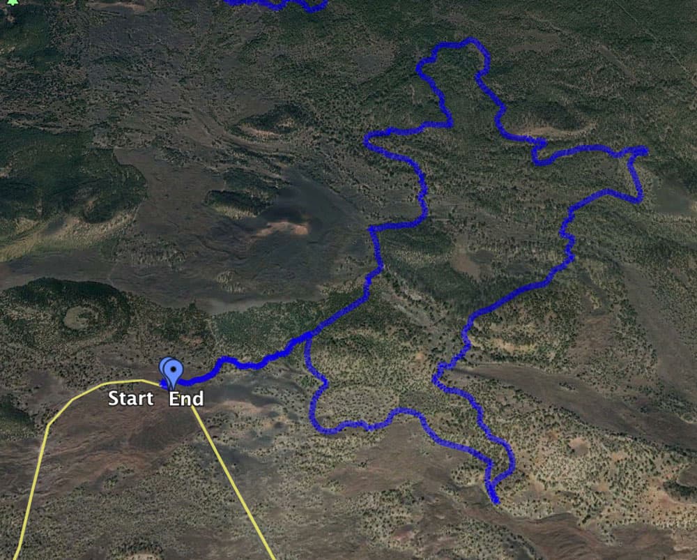
Track of the Tenerife circular walks around the Montaña la Corredera
General information about the Tenerife circular walks on the Montaña de las Cuevitas and around the Montaña la Corredera
Starting point and approach
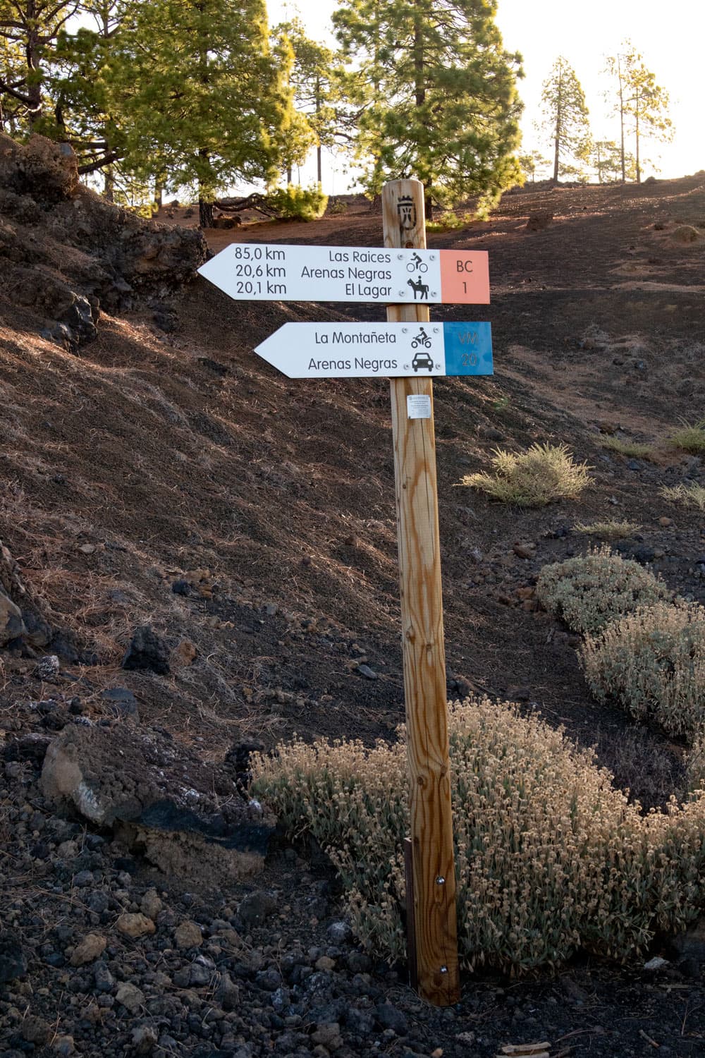
signpost for long distance hikes at the starting point
The tour to the Montaña de las Cuevitasstartet at the TF-38 (between Chío and Boca Tauce) at km 12. And the hiking trail also starts there and there is space to park some cars.
Tour start around the Montaña la Corredera is kilometer 15 at the TF-38. There is good parking at the roadside at the Chinyero excellent area.
Arrival by car
If you come from the south of the island Tenerife and also from the north from the island motorway TF-1, take the exits Guía de Isora or Chío. Then take the TF-38 towards Teide National Park. Those who come from the centre of the island via the Cañadas road TF-38 drive in the direction of Chío or Santiago del Teide. At kilometre 12 (Montaña de las Cuevitas) or kilometre 15 (Montaña de Corredera) the Tenerife circular walks start.
Arrival by bus
Unfortunately, it is not possible to reach the starting point of these hikes by bus, as there is no Titsa bus that runs this route.
Time
I don’t like to give general time information for hiking tours, as the times are very individual. And also I need for each tour sometimes more and sometimes a little less time. For the round to the Montaña de las Cuevitas we needed with an extensive summit picnic scarcely 3 hours. For the round around the Montaña de Corredera it was more than 4 hours.

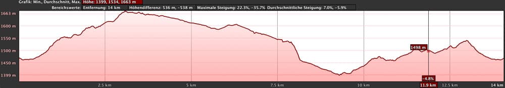
Tenerife circular hikes - elevation profile Montaña las Cuevitas
Article summary and large selection of GPS hiking tracks
Sign up for my newsletter now and get exclusive access to my collected GPS tracks as well as all the brief information about my articles.
Sign up nowDifference in altitude and distance
The height difference for the migration on the Montaña de las Cuevitas amounts to approx. 320 metres. The route is almost 12 kilometres long. You start at an altitude of 1625 metres and have reached an altitude of 1807 metres on the summit.
Tenerife circular walks - elevation profile Montaña la Correderra
At the round around the Montaña de Corredera 450 meters of altitude have to be overcome. The route is 14.5 kilometres long. You start at an altitude of 1450 metres.
Requirement
Both Tenerife circular hikes are easy and for everyone with a bit of stamina easy to master tours. But as these are not signposted circular hikes with some branches, I would definitely recommend to go to JPS Track. You can download it for free from me.
Refreshment
There are no places to stop for refreshments. Therefore, take enough water and food with you.
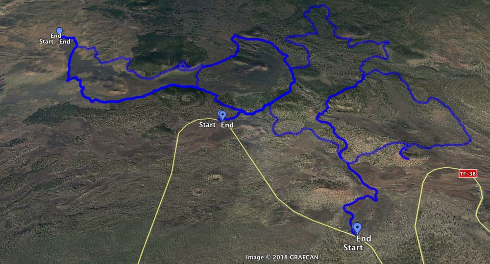
Tracks Tenerife circular walks - left to right Chinyero- Montaña la Corredera - Montaña de las Cuevitas
Variants
Both Tenerife circular hikes can be combined well with various other hiking tours in the vicinity. Above this tour is the circular walk Samara. Below these tours are the circular hikes around the volcano Chinyero. On the track pictures you can see all the circular hikes. You will also notice that today’s two circular tours overlap on a straight line. So they can also be combined wonderfully.
View on Chinyero and Montaña Negra
The paths to the Montaña de las Cuevitas are for the most part a little wider and easier to find than the paths around the Montaña de la Corredera. But the latter hike is a little longer. On the Montaña de las Cuevitas you have a summit ascent. You can see that both Tenerife circular walks have their advantages. Just try out what suits you best. And don’t forget to download the free JPS tracks first.
Here in the nature reserve Parque Nacional de Corona Forestaldamit you have many possibilities for beautiful circular walks, which you can combine as you wish.

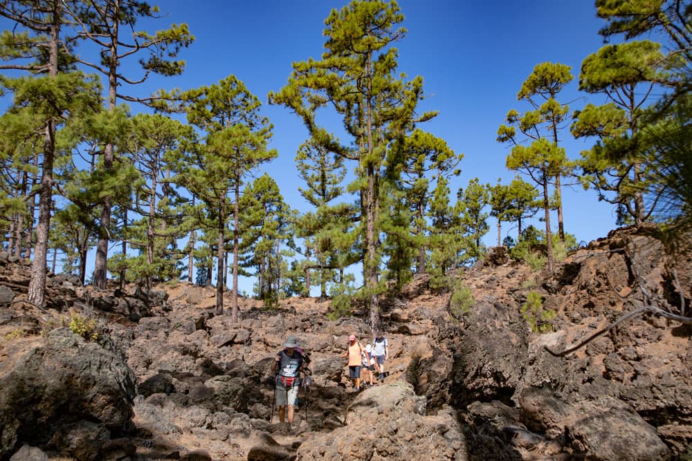
hiking over lava beneath Mount Teide
Circular hike to the Montaña de las Cuevitas
Section of hiking trail along the TF-38 km 12 to Montaña la Corredera
You start your circular hike on the TF-38 at kilometer 12 at 1625 meters altitude. A wide road branches off here and you follow it. You will find two hiking signs pointing to the BC 1 long-distance trail and the road to the Arenas Negra picnic area and La Montañeta. Follow this path straight ahead for a while. It leads you to a hill (Montaña Cascajo), which you bypass on the right. After going around the Montaña Cascajo, a path branches off to the right. This is your way back. Continue straight ahead along the wide main path.

Hiking through the pine wood
After a short time a path comes up from the left to the main path. This is part of the circular walk around the Montaña la Corredera. From now on, as long as you stay on the road, the path is the same for both circular walks. You now walk slowly downhill on the road in wide arches first through pine forest, then past large lava fields. Finally you come back to the pine forest. On your left is the Montaña la Corredera. In good weather you have a good view towards Chinyero and Teno mountains.

hikers on the hiking road - Montaña de las Cuevitas
Route section Montaña la Corredera to wide hiking trail
After a very long descent on the road, the hike around the Montaña la Corredera continues to the left on the main road. However, you now continue to the right of the path on an initially wide path that is blocked by a barrier. Follow this wide path through the pine forest uphill for a while. Now the right ascent begins.

View on Mount Teide and Pico Viejo
At a place that is difficult to describe, but marked with a stone man (see photo below), a small path climbs steeply up the mountain on the right. Now you walk on this path, which takes you through a forest into a small gorge. You walk a little straight through the gorge and then keep left uphill on the small path. After a short steep ascent this will bring you over the small gorge. You hike up over the gorge. The path leads you through rocks and partly a little rough. Finally, however, you reach a wider path again.

Hiking dog Lasko Labrador
Article summary and large selection of GPS hiking tracks
Sign up for my newsletter now and get exclusive access to my collected GPS tracks as well as all the brief information about my articles.
Sign up nowSection of wide path to Montaña de las Cuevitas
This way you turn right. After a short time the path forks. The wide main path goes around to the left. However, you climb on the smaller path that leads you up to the right. You are now at 1650 metres above sea level and are already below the Montaña de las Cuevitas. If you look at my different tracks, you now have two options. The orange track leads you in a wide arc around the basin. However, I continued on the blue track on the ridge path. Here it went down steeply into the valley on the left side.

View from Montaña de las Cuevitas to Montaña de la Corredera
You hike through the valley and then have to climb up the ridge again in a short but very steep ascent. Therefore the orange variant is preferable. So you come from behind to the summit and ridge of the Montaña de las Cuevitas. Either way. After a last steep ascent you are on the summit ridge and can enjoy a wonderful view of Teide, the Pico Viejo, the Chinyero, the Montaña la Corredera, the whole nature reserve and further on over Tenerife. Here, at 1807 metres above sea level, you should definitely plan a rest at the summit.
ridge of the Montaña de las Cuevitas
Montaña de las Cuevitas to car park at the TF-38 km 12
You go back on the ridge path until you reach the point where you either went down into the valley or from behind to the summit. But now you go around on the path to the left, which takes you slightly downhill. You cross a small lava valley and walk a little up and down.

View from the Montaña de las Cuevitas
Then it goes through a light pine forest steadily downhill. Finally the path brings you back to the wide road you took on the way there. Here you turn left. And after some time you are back at the starting point.

lava and pine trees
Hike around the Montaña la Corredera
Section parking at the TF-38 km 15 to driveway
You start this hike at the parking lot at TF-38 km 15. From here you follow the signs to the Chinyero hiking route, which I have also described here. After a short time you will reach the Chinyero Circuit from the parking lot. There you walk around on the right between pines on the main path uphill. But after a short time you leave the Chinyero main path and take a right uphill path. Here in the pine forest you hike uphill in large arches until you reach a large road.
hikers on the trail through the wood
This is the path that also belongs to the hike to the Montaña de las Cuevitas. Now walk as described above along this wide road to the left. From now on – as long as you stay on the road – the path is identical for both circular walks. You now walk slowly downhill on the road in wide arches first through pine forest, then past large lava fields. Finally you come back to the pine forest. On your left is the Montaña la Corredera. In good weather you have a good view towards Chinyero and Teno mountains.
view on the Chinyero
Section of road to the junction forest trail
After a very long descent on the road, the walk around the Montaña la Corredera continues to the left on the main road, while the walk to the Montaña de las Cuevitas branches off to the right. You continue along the main path. If you keep following this path and ignore all the paths that branch off to the right, you can extend the hike a little and stay on the circular path. But you can also use my track and take a shortcut to the left on small forest trails.

hiking along lava fields
This will take you through the forest on mountain slopes and through small gorges back to the main path, which you follow once more to the left. After some time the path leads into another road, which you follow to the left again. But after a short time you turn off the road again onto a small path to the left into the forest. Continue straight ahead to the Chinyero main road.

hiking dog Lasko - rest at the summit
Follow the road until you reach the starting point of the car park.
So if you go straight ahead, you will get to the Chinyero main path, where you go around on the left. If you take the shortcut through the forest, which I can only recommend with Track, you will also get back to the Chinyero main path, which you now also walk along to the left. From this path over the volcano Chinyero you have beautiful views of the dark Chinyero and the surrounding lava fields.
After some time the path will lead you down again. You pass the point where you turned right on the way there. After a short time you turn left from the Chinyero main road towards the parking lot.

Montaña de las Cuevitas
And finally
I hope that you enjoyed the two Tenerife walks in the Parque Nacional de Corona Forestal. They can be combined with each other as well as with the surrounding tours. I wish you lots of fun hiking,
Dagmar von SiebenInseln