Barranco or gorge – the longest Barrancos of Tenerife
Today’s circular walk also takes you along a large Barranco again. This time it is the Barranco de Erques. Barranco is the Spanish word for gorge. And of these gorges there are truly some on the Canary Islands. And also Tenerife has more to offer than just the well-known Barranco of Masca. Today I brought you from the website www.aguastenerife.org a list of the longest Barrancos of Tenerife. The numbers are kilometers/meters.
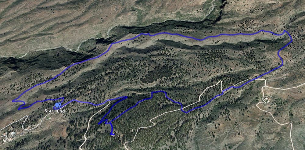
Map
waterfall Barranco de Erques
Barranco el Charcón 25,25
– Uchoba o Ifaya 25.03
– la Orchilla 24,39
– del Rio 24.27
– de Las Galletas 23.79
– de Géñiga o de las Vegas 22.31
– Bijagua o de Abejones 22.18
– del Rey 21.51
– Polegre o Barranco de Tajo 20.11
– de Tamadaya y de las Carretas 18.83
Barranco de Erques
Barranco Hikes in Tenerife
The most famous Barranco walks in Tenerife lead through the Barranco of Masca and the Barranco del Infierno. But the popularity of these Barrancos has also led to the fact that in these two canyons, the tourists almost accumulate. Thereby, there are almost identical canyons in the immediate vicinity. Right next to the Barranco of Masca are the Barranco Seco and the Barranco Natero. I also wrote about these two here. They are in no way inferior to the Barranco of Masca, except that there is no boat down at the beach that takes you home. So it is called the often difficult way back in the height to start. And not far from the Barranco del Infierno you find the Barranco de Erques.
ascent hiking path Barranco del Agua
But whether you decide for a Barranco hike or a walk on a path above the Barranco, the gorges are fascinating to look at with their towering rock walls. They were formed many millions of years ago by volcanic eruptions, rock shifts or were washed out of the rock by torrential rivers. This circular walk also takes you across the Barranco del Agua and along the edge of the deeply cut Barranco de Erques.
hike along the Barranco de Erques with a side trip to the abandoned house
General information on the Barranco de Erques circular walk
Starting point and approach
Article summary and large selection of GPS hiking tracks
Sign up for my newsletter now and get exclusive access to my collected GPS tracks as well as all the brief information about my articles.
Small parking lot above the small village La Concepción near the Barranco de Agua.
starting point at the street
Arrival by car
The approach to this beautiful circular walk is from the north or south on the TF-82. If you are coming on the TF-1 motorway, take the Guía de Isora exit and drive south through Guía de Isora towards the coast/Adeje/Las Americas. At a large junction, take exit TF-585 up left towards La Concepción, Tijoco Alto and Tijoco Bajo. From the south, coming from Adeje, take the TF-82 to this junction, where you turn right onto the TF-585. You will continue up through all the villages for about 7 kilometres.
Keep going straight ahead on the main road, which leads you in large and small serpentines into the mountains. The last place you pass through is Tijoco Alto and the street is called Calle Tijoco Arriba. A few hundred meters behind the last house of the village there is a water reservoir on the right side. On the left is a large concrete building. Here you can park your car and the hiking trail starts right next to the building.
Arrival by bus
From Adeje and Guía de Isora the Titsa bus line 417 goes to Tijoco Bajo. From there you have to walk up to the starting point on the main road. You can find more information and details about bus connections on Tenerife on the Titsa homepage.
Time
I don’t like to give general time information for hiking tours, because the times are very individual. We needed almost three hours of pure hiking time for this hike, but were on the way for more than four hours.
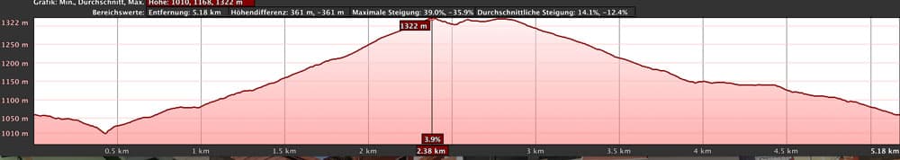
elevation profile Barranco de Erques with side trip to the abandoned house
Difference in altitude and distance
The difference in altitude is about 300 meters. But gross through a little up and down then, nevertheless, approx. 380 meters of altitude have become. The distance is approx. 6 kilometers long.
driveway to Acojeja
Requirements and remarks
Mostly it goes on this round tour on quite good footpaths along. As also the differences in altitude are not as big as on the hike around El Jaral , this small hike is a really for everybody feasible beautiful round tour.
hiking path along the waterchannel
Refreshment
The next bar/restaurant is in Tijoco. On the way you have no opportunity to stop. Therefore take enough water and food with you.
Variants
This tour can be combined well with various other hiking and circular walks in the vicinity. If you want to hike even further, you can simply hike a little further up in the upper part. You can also extend the arch back a little further and make it bigger at any time.
tree with chairs and waterchannel
Circular walk at the Barranco de Erques
Tijoco section Parking until Grat Barranco de Erques
You start your hike to the Barranco de Erques at the above described parking lot above the small village Tijoco. There you take the hiking trail first to the left and then past the concrete building at the back. For a short time the trail will lead you through a little forest. And then you stand at a Barranco edge. This is the Barranco del Agua. You follow the path along the Barranco edge and can already take a look at the Barranco and the opposite gorge side.
Article summary and large selection of GPS hiking tracks
Sign up for my newsletter now and get exclusive access to my collected GPS tracks as well as all the brief information about my articles.
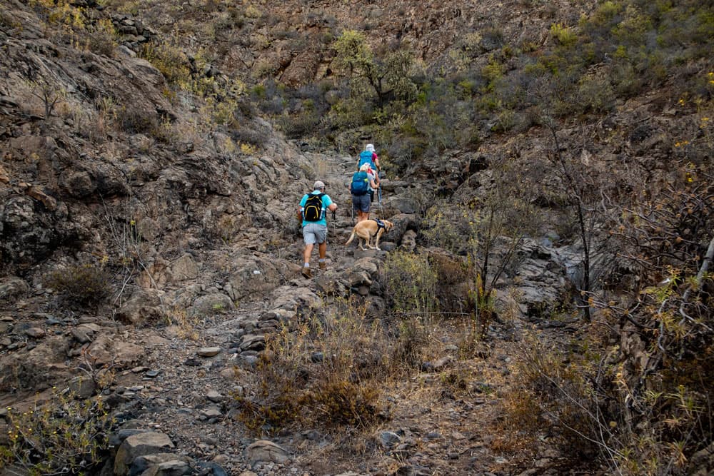
After a short time the main path continues straight ahead. But you turn right on a path down to the Barranco del Agua. Strictly speaking, this is only a small branch of the large Barrancos del Agua. Because in a short time you will already be on the Barranco ground you are crossing. On the other side the path leads you up again in a steep ascent. Then you are on the ridge between the Barranco del Agua and the great Barranco de Erques.
Hiking path - Barranco del Agua
Section of the Barranco de Erques ridge
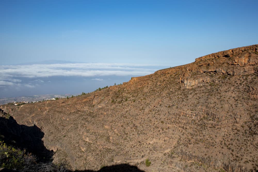
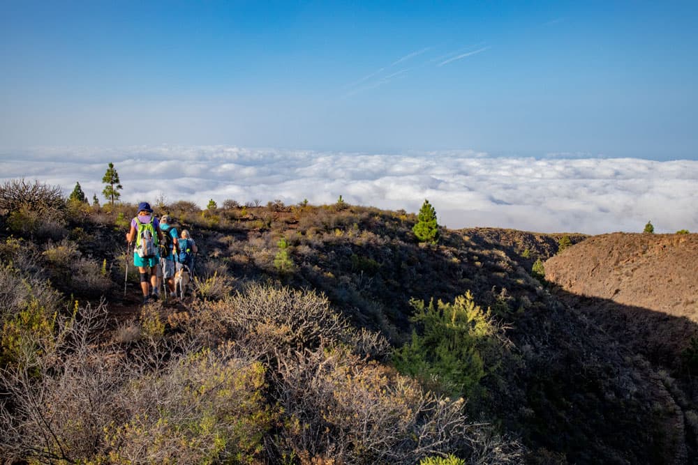
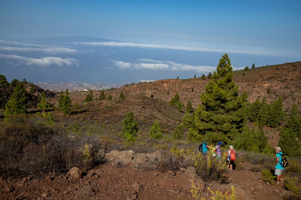
On the ridge way it goes quite straight uphill. The path takes you closer and closer to the edge of the Barranco de Erques. If you then stand right on the edge of the gorge, you have a fantastic view from the top into the depths of the gorge. On the horizon behind you you can see the south coast and in good weather the neighbouring islands. But not only the view into the distance but also the view into the great depth of the gorge directly in front of you is impressive.
view on the southcoast and La Gomera
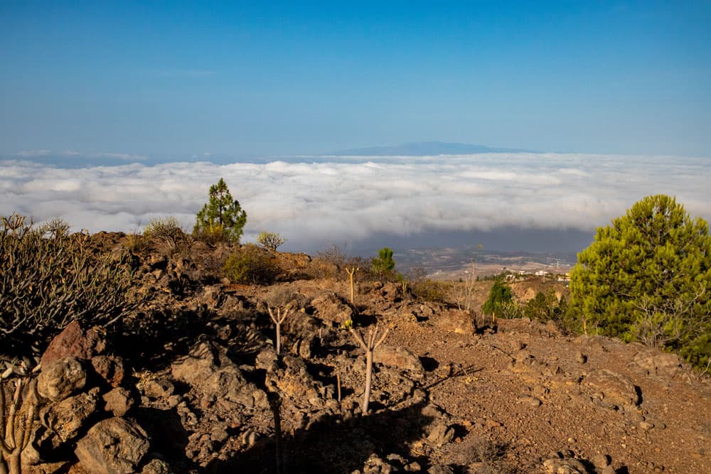
On the opposite steep rock face you can discover a waterfall that falls from high above into the depths. Whether it can be seen and how strong it is depends on the season. You keep on hiking up the ridge, which is easy to see and which you can’t miss. First you can enjoy the impressive view of the opposite rock faces of the Barranco de Erques. Then the path to the right leads you away from the Barranco.
An old open waterchannel along the path
Section of the Barranco de Erques ridge path to the driveway (large tree)
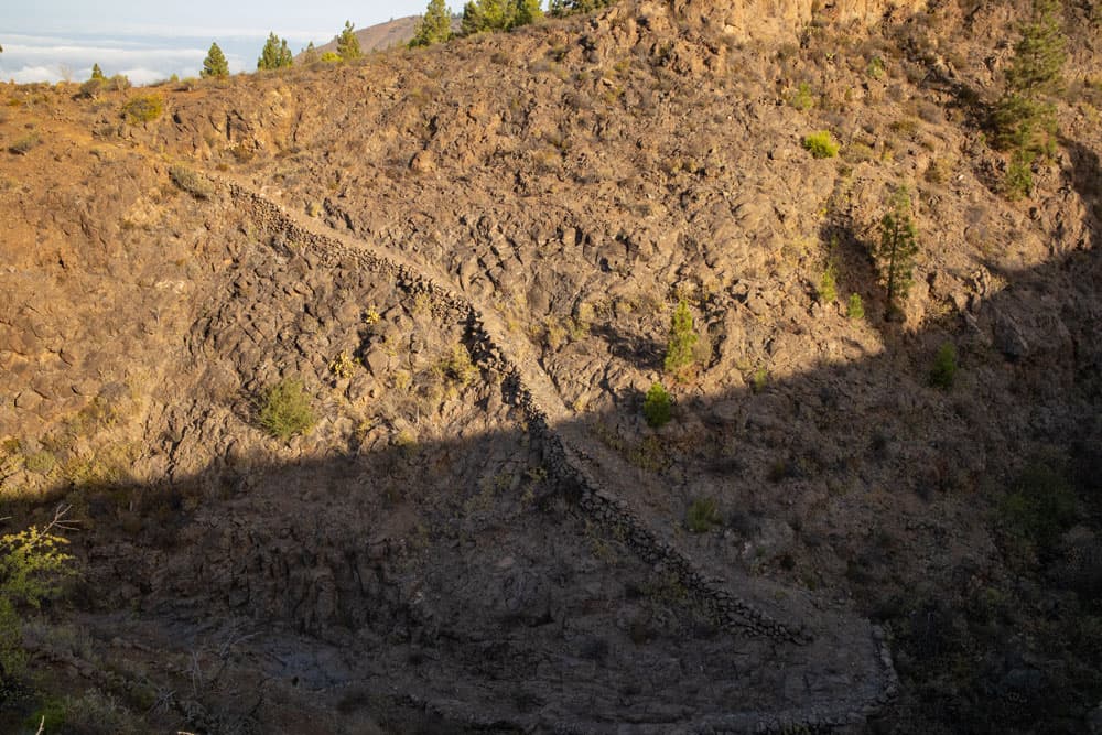
After a while the main path takes you down to the right into a smaller Barranco. If you want to extend the path, you can continue straight ahead and make a bigger turn. But this small round will lead you down to a Barranco. At the end of the Barranco you bypass it on a path that leads you through a lot of green very close to a water channel. Here again there are trees and even small gardens. On the other side, you go up a bit. Then the path crosses a larger open water channel.
lonely pine tree
For a while the path on the right leads you down the mountain. You always walk parallel to a water channel. Shortly after you reach a wide road, which you cross and continue on the opposite side. It won’t take long and then you’ll meet the same road again. On the left side you can see abandoned houses in the distance. You turn left into the driveway and follow it for a short time. On the right side you will see a big tree after a while. When I passed by there were picturesquely many chairs set up there. A pretty place to stay.
crossway between the ridges through pinetree wood
Road section (large tree) to empty house in the forest
At a sharp bend, which the road makes to the right, you continue straight ahead a little later. It goes straight ahead in a pine forest down the hill for a while. Then the path turns right and you cross the road again. The trail continues on the opposite side. First the path takes you straight ahead and then for a long time left through the forest further downhill. At a point where you can already see the houses of Tijoco below you, a small path leads you off to the left from the main hiking trail.
Hiking over the ridge between the Barrancos
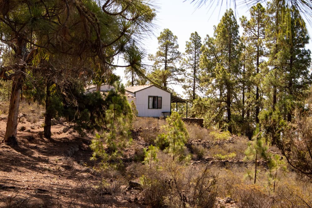
This path takes you to an abandoned house in the forest, which you can already see from the main path. A ruin that seemed to be inhabited not so long ago. From the veranda there is a nice view. The ideal place for a small final picnic. When you have visited the house, which is worth seeing, you go on the small way back again to the main way.
Abandoned house in the wood above Acojeja
Section abandoned house in the forest to parking lot
Back on the main hiking trail, the path in the forest takes you downhill in large serpentines. Now it’s really downhill again. It is also possible to make a small shortcut that will bring you down the slope to the main path. After some time you will come back to the larger road, which will take you further towards Tijoco.
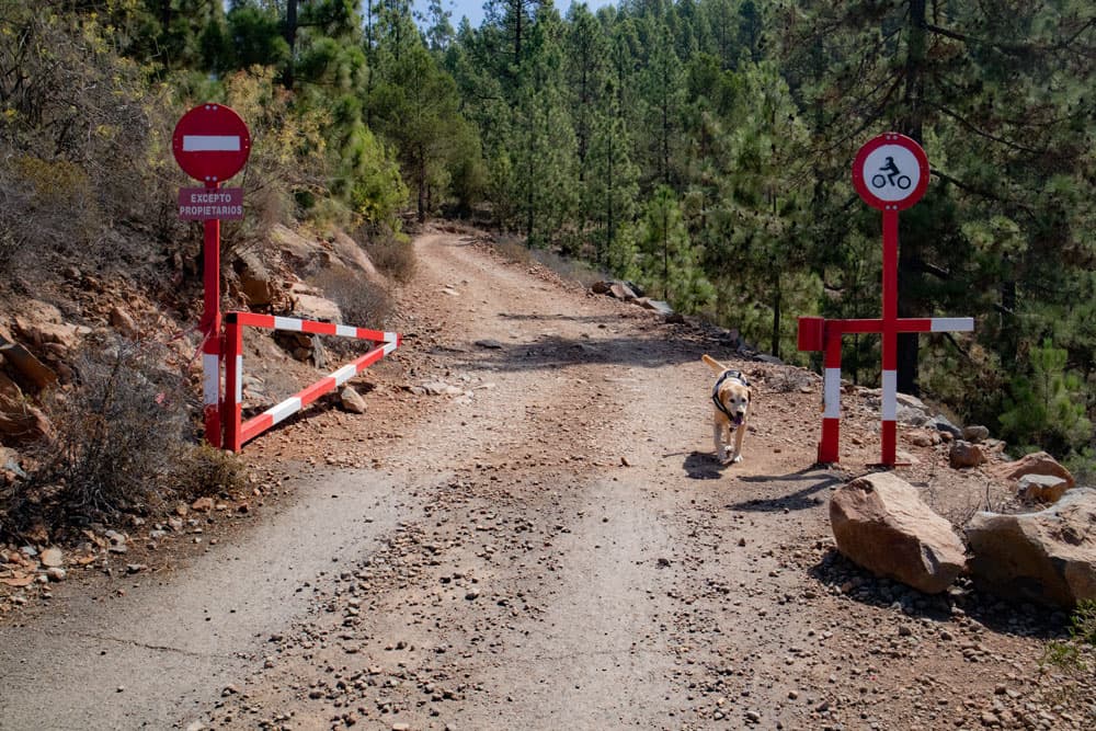
You pass a barrier and go a little further straight ahead. After a short time you will reach the road to Tijoco. You turn left. After that it won’t take long and you are back at the starting point.
abandoned house veranda - circular Barranco de Erques
And at the end
I hope you enjoyed this little walk around the Barranco de Erques. If you plan to hike in Teide National Park in October or November, please note that mouflon hunting starts there in October and trails are closed. You can find out more here. I wish you a wonderful hiking experience in the future,
Dagmar von SiebenInseln
Thank you for reading!
If you've found my hiking guides on SiebenInseln helpful for your Canary Islands adventures, please consider leaving a small tip. Your support is greatly appreciated and helps cover the costs of maintaining this blog.
Thank you for your support!
SSL secured
Comments
Volodymyr - 10/22/23, 05:35 PM
We did this haike today and I was really impressed with views from Barranco de Erques. Especially when in the first part of the trail you pass along the upper part of the gorge. Thanks for the trail and GPS track for it.
Dagmar - 10/22/23, 08:25 PM
You are welcome – glad you enjoyed the hike
Volodymyr - 10/22/23, 05:37 PM
Forgot to mention, it tooks 1h 40min to finish trail and ascent by my watch was 351m.