Fascinating canyon and high-altitude hike near El Jaral
This circular walk near the town of El Jaral starts on the south side of the Barranco del Achacay or Barranco Pozo. First we go down into the deep Barranco Pozo and on the opposite side up again to the idyllic mountain resort El Jaral.
Map

Barranco Pozo - Barranco del Achacay - hikers on the way close to El Jaral
From there the hike takes you up the other side of the Barranco. Once again you cross the Barranco Grund. On a mountain ridge you continue uphill.

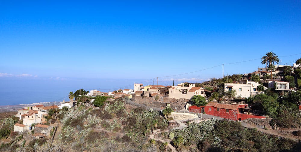
View on El Jaral from the hight
From the top you can enjoy fantastic views over the entire south and west coast of the island of Tenerife to the neighbouring islands. There are almond and fig trees from which you can even harvest the fruits depending on the season. Finally, after you have circumnavigated another Barranco, you return on another mountain ridge towards the parking lot opposite El Jaral.

village street Las Escuelas in El Jaral
El Jaral – an idyllic mountain village
In El Jaral tourism has not really arrived yet. But there are already some holidaymakers there who enjoy the peace and seclusion of the place. El Jaral is better known by hikers, as some beautiful hiking trails converge in this small village. But even if El Jaral has no special sights to offer, a walk through the pretty lanes of the small place with its colourful houses is worthwhile.

view over the Barranco to the south coast
There is no bar or restaurant. When I was once in El Jaral years ago, a kind of bar/restaurant opened its rooms exclusively in the late afternoon. Whether this is still the case today, I unfortunately couldn’t find out during my last visit a few weeks ago.

Track circular hike around El Jaral
General information about the circular hike at El Jaral
Starting point and approach
The starting point of the hike is a small natural car park on the right side of the road above Acojeja on Calle el Chorro. This is located on the right side of the road at Barranco Pozo, opposite the town of El Jaral.

Starting point: parking above Acojeja
Arrival by car
Coming from north or south on the TF-82, if you are coming on the TF-1 motorway, take the Guía de Isora exit and head south through Guía de Isora towards the coast. About 2 kilometres south of Guía de Isora, turn left off the road towards Acojeja. Continue uphill through the town of Acojeja. At first this street is called Calle El Chile. Later it is called Calle El Choro. After the last building of Acojeja it is about 500 meters. Then you will see a footpath on the left hand side. Opposite another footpath leads to a climbing rock. There is parking space here.
Arrival by bus
From Guía de Isora the Titsa bus line 417 goes to Acojeja. From there you have to walk up to the starting point along the main road. Further information and details about bus connections on Tenerife can be found on the Titsa Homepage. 
Start: hike to the Barranco Pozo - El Jaral on the other side in the background
Time
Article summary and large selection of GPS hiking tracks
Sign up for my newsletter now and get exclusive access to my collected GPS tracks as well as all the brief information about my articles.
Sign up nowI don’t like to give general time information for hiking tours, because the times are very individual. We needed almost three hours of pure hiking time for this hike, but were on the way for more than four hours.
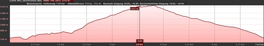
Difference in altitude and distance:
The difference in altitude is about 600 meters. But gross through a little up and down are then, nevertheless, almost 700 meters of altitude to be mastered. The distance is approx. 7.5 kilometers long.
elevation profile circular hike El Jaral
Requirements and remarks:
Mostly it goes on this round tour on quite good footpaths along. In the upper part, however, the paths are a little wild and overgrown and from time to time a little filled up. But with small detours there is always a way through. Of course you need a little physical condition for the ascent. In storm and rain this tour is not recommended. Since there is little shade on the main part of this tour, you should definitely think about sun protection in summer and the warmer months. If you want to avoid scratches on your arms and legs from the many bushes, you should wear long trousers and possibly shirts.

Hiking Board at El Jaral
Refreshment
The nearest bar/restaurant is in Acojeja. On the way you have no opportunity to stop. In El Jaral there was a bar years ago that was only open temporarily. You probably cannot rely on that. Therefore take enough water and food with you.
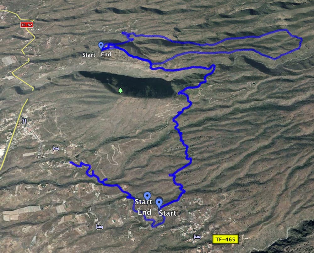
Track of the circular and another track from Vera de Erques to El Jaral
Variants
This tour can be combined well with various other hikes and circular walks in the vicinity. Possible combinations include hikes from Guía de Isora and Chirche. 
Panorama - view from the hight - landscape and southcoast
Circular hike near El Jaral
Section car park to El Jaral
You start your hike towards El Jaral on the parking lot described above. The trail starts on the opposite side of the road. This will lead you straight ahead and then to the right. Then you are already standing in front of the huge Barranco Pozo, which you cross on the way to El Jaral. The hike takes you down into the Barranco on stony paths on the right side of the slope. And the path is quite steep, so that you quickly approach the bottom of the Barranco. But the path is well predictable.

threshing floor on the wayside
After you have crossed the Barranco Ground, it doesn’t go up again at least steeply on the opposite side of the slope. All the time you can already see some colorful houses of the village El Jaral, which are located directly at the edge of the Barranco, high above you. After you have mastered the steep ascent, you stand in the small village of El Jaral. The dirt road turns into Calle Cuba, which you are about to follow. At the next junction, turn right. Then turn right again at the next crossing. You are in Calle Las Escuelas.

houses in El Jaral at the demolition edge
El Jaral to ridge above Barranco Pozo
The street Las Escuelas makes an arc in El Jaral and leads you past the houses of the place again in the direction of Barranco. The road first turns into a driveway and then into a narrow path. This path takes you along the left side of Barranco. Now you don’t descend into the Barranco, but go slowly up the slope with the course of the Barranco Pozo. Even if the descent is short from time to time, the tendency is upward.

hiking path Barranco Pozo - Barranco del Achacay
When you have almost reached the upper end of the Barranco, it goes down again briefly and you cross the bottom of the Barranco to get back to the other side. From there the path leads you up in a very steep climb in serpentines. At the top of the Barranco edge, you go to the side of the slope facing away from the Barranco. From here the path takes you straight up the ridge. After a few descents and ascents you are now at about 900 metres above sea level. You simply follow the path that runs along the middle of the ridge. From up here you already have beautiful views back to Barranco, El Jaral and the coastline behind you.

Steep wall in Barranco and in the height the houses of El Jaral
Route section ridge over the Barranco Pozo to the slope path
Article summary and large selection of GPS hiking tracks
Sign up for my newsletter now and get exclusive access to my collected GPS tracks as well as all the brief information about my articles.
Sign up nowAs you continue to follow the ascending path, you will pass an abandoned farm on your left. Now the Barranco las Palomas is on your left. On the lower right next to you is the Barranco de Chimeque. You walk along the ridge with beautiful views. Partly the path runs between walls. In front of you you can already see an elevation. This is where the Barranco de Chimeque ends, which is on your right. This elevation is your next destination. You walk along the ridge path until it merges into the slope in front of you.

Abandoned farmstead on the hiking trail
Now keep to the right on a narrow path that leads you slowly up the mountain. This part of the slope is a bit confusing. Partly the path is overgrown or buried. Here you have to pay a little attention and look out for the further way from time to time. With JPS nothing can happen to you. But even without JPS your direction is fixed. You go along the slope path to reach the opposite mountain ridge. Even if the path along the slope is a bit wild, the impressive nature around you will certainly compensate you. The path is lined with cacti and almond trees. Depending on the season, you can enjoy the almond blossom or harvest almonds.

View over the Barranco to a lonely situated house
Route section along the slope to the ridge above the Barranco Chimeque and the Barranco Flaire.
Here on the overgrown slope you also made the last ascent. You are now over 1,300 meters high. The slope path itself brings you up and down in some places, but basically maintaining height on the other side. At the end of the slope the path leads you into a small valley with almond trees. There the path is quite confusing due to various burials. You are in front of a slope that you have to climb to get to the ridge. Possibly the right path is now clear again. During my last visit there it went a little through the bushes and over rocks to get to the ridge.

hiking trail on the ridge between walls
When you are on top of the ridge, the Barranco del Flaire is on your left and the Barranco de Chimeque is on your right. If there are no clouds, you can enjoy wonderful views in all directions from the height. Then it goes on a narrow ridge way slowly downward. From time to time paths turn right and left. These lead down into the respective Barrancos. However, you choose your route so that you keep as close as possible to the middle of the ridge.

Hiking over the ridge in the clouds
Section over the ridge of Barranco Chimeque and Barranco Flaire to Camino de Choro
After some time on the ridge road you get to some kind of corner. Here the path leads to the right. Since it is a bit hidden, a white arrow on a stone points to the entrance. It continues slightly downwards. After some time the path leads around a very big fig tree. Because of the many fruits on the tree it is also called Golden Fig Tree. If you happen to pass there in September/October and are hungry, you can harvest some figs (width 28°11’58.45 „N length 16°44’15.53 „W). Then you go further down with the path that occasionally runs through bushes and along rocks.

almonds trees and almonds on the way
After some time you will come to a wide road, which you can follow straight ahead. It is more scenic if you climb up a small path on the left and continue descending just above the ridge. Slowly you reach the agricultural area. In front of you you can see a water reservoir. You come back onto the wide road. To the right and left are terraced fields, gardens with vines and also small fincas next to you. Continue straight ahead downhill. Here you are already on the Camino de Choro again.

hiking trail over white rocks
Camino de Choro section to parking lot
You continue to follow the road through gardens and fields. After some time the path turns left. But you continue straight ahead along a small path along the edge of the field. From here it goes straight downhill to the parking lot. Often you will reach the road to Acojeja, where you came by car or on foot. It winds its way downhill in serpentines. However, the trail is shorter and steeper. Not to be overlooked it leads down a wide white rocky path through the middle of the serpentines.

Road - Hiking trail through vineyards and gardens
This Camino seems to be very old and probably used to be a straight connection from Guía de Isora to the mountain villages. Now this comfortable path offers a quick descent. In front of you you can see El Jaral on the other side of Barranco and the coast on the horizon. The trail ends on the left side of the road just before you reach the parking lot at the starting point.

Track and terraced fields
And finally
I hope that you enjoyed this beautiful tour over El Jaral as well as the gorges and heights of the surroundings. And if you are there at the right time, you can even enjoy almonds or figs. I wish you beautiful, eventful – and in this case also nutritious – hikes,
Dagmar von SiebenInseln