Chirche – a picturesque Canarian village
The small mountain village of Chirche, which is the starting point of this hike, is situated at an altitude of about 800 metres. There the houses are built in the typical Canarian style and are picturesque to look at. These houses in the village today date from the 18th and 19th centuries.
Map

the hiking trail leads around a large vineyard above Chirche
But the origins of the village probably go back as far as the Guanches. However, records of the village’s history do not exist until the late 17th century. Chirche was declared a cultural asset in 2008. If you walk along one of the many trails around Chirche, you will come across many threshing floors, baking ovens and washing places that bear witness to the life of generations long past.

Hiking trail through the pine forest above the Barranco de Tagara
Initially, the inhabitants of Chirche lived mainly from livestock farming and also from dry farming. You can still discover many terraced fields around Chirche and on your walks around Chirche. Therefore, you should not miss to visit the village and the small neighbouring village Aripe during your hikes around Chirche. You can also get a nice overview from the Mirador Chirche, which lies close to the TF-38 high above the village and is the starting point of this hike. And if you want to get a closer look at the life of the original population, it is worth visiting the Day of Traditions, which takes place annually in the town in the second half of July.

View of the coast and the neighbouring islands of Tenerife from the hiking trail
Circular hike from Chirche over the Barranco de Tagara
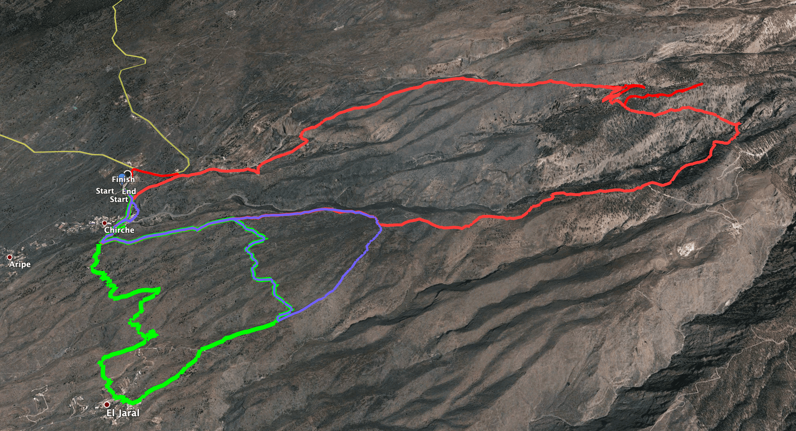
From Chirche you have many possibilities for hiking. I will show you some of my routes below in the section on variants. This hike is a bit demanding, as it is a steep climb of over 1000 metres in total. In addition, the crossing of the Barranco de Tagara is quite strenuous, at least at the moment (as of April, May 2021), because the path is blocked by many fallen trees. In these places, progress is slow because you either have to go around the trees or climb over them. However, for those who love this sort of thing, it can be fun.

In the clouds on the ridge path above Chirche - View into the Barranco Tamuja
If you don’t want to do such a strenuous hike, you can do this hike from Chirche in parts only. You can walk uphill on a ridge above Chirche and downhill when you can’t anymore. The same goes for the way back. You can also reach the Barranco de Tagara from Montaña El Cedro via the Cañadas road at Mirador Narices del Teide from the heights on a shorter route. Or you can choose another of the numerous hikes around Chirche. 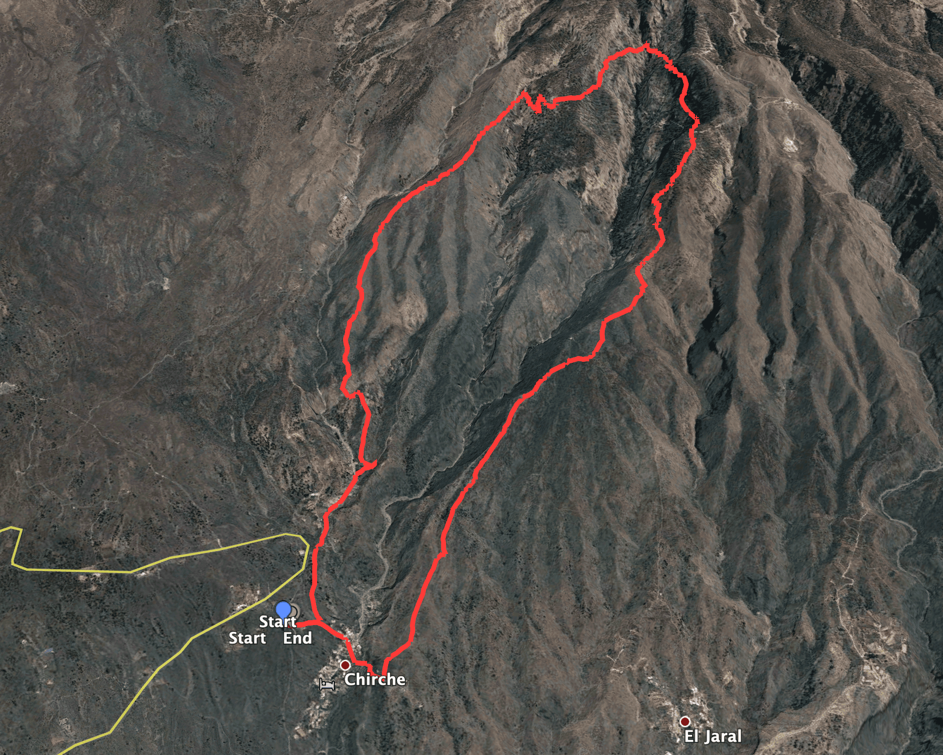
Track of the circular hike Chirche - Barranco de Tagara - Chirche
General information about the circular hike Chirche – Barranco Tagara.
Starting point and access
The starting point of this hike is the Mirador Chirche. It is located on the TF-38 high above Chirche. Alternatively, you can drive from Guía de Isora to Chirche and from there drive or walk up to Mirador Chirche.
Getting there by car
From the north, you can drive through the Teide National Park via the TF-38 or via the TF-1 motorway. You can also take the motorway from the south. Take the Chío exit and drive towards Chío. Just before you reach Chío, turn onto the TF-38 towards Teide. Between KM 24 and KM 23, a small road branches off to the right towards Chirche. After a short while you will come to the Mirador de Chirche. There is a large car park where you can park.
Arrival by bus
Unfortunately, there is no Titsa bus service on the TF-38 and there seems to be no connection to Chirche either. You could walk from Guía de Isora to Chirche on the hiking trail, but this would require more time and some altitude gain. Certainly not suitable for everyone. Details of the bus service to Guía de Isora can be found on the Titsa homepage www.titsa.com. Otherwise, you can also order a taxi from Chío or Guí de Isora to Chirche, which will not necessarily be expensive because of the few kilometres.
Article summary and large selection of GPS hiking tracks
Sign up for my newsletter now and get exclusive access to my collected GPS tracks as well as all the brief information about my articles.
Sign up nowTime
I don’t like to give general times for hiking tours, as the times are very individual. We needed a little over 6 hours for this tour, including an extensive rest.
Difference in altitude and distance
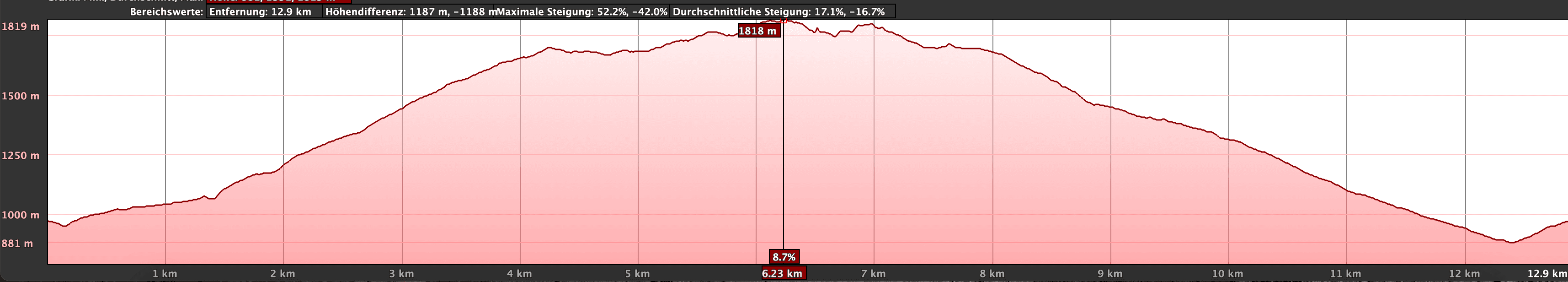
Höhenprofil der Wanderung Chirche - Barranco de Tagara
The difference in altitude is about 1000 metres and another 200 metres gross. The route is about 14 kilometres long.
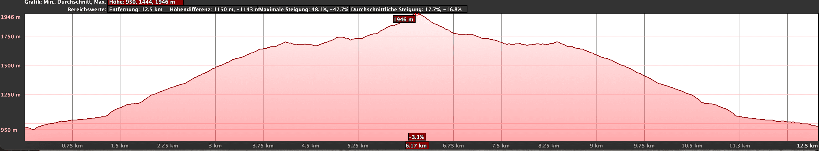
Altitude profile of the hike Chirche - Barranco Tagara and back (one way)
Requirement
This hike requires a very good level of fitness. On the way there, the trail is on „normal“ hiking paths. On the way back, the trail is a bit slippery on the second half, as you have to go downhill over some steep scree paths. Therefore, if you want to avoid the rough paths downhill, it might be a good idea to do the hike in the opposite direction. You could then go down on the normal trail. The traverse through the Barranco de Tagara requires some scrambling. At least at the moment (as of April, May 2021) you will have to climb over a lot of fallen trees. The traverse of Barranco de Tagara and Barranco El Sauce also requires surefootedness and a head for heights.
Refreshments
Restaurants, bars and shops are only available in Chirche (at the starting point). Therefore, take enough water and, if necessary, food with you.
Track of the hike Chirche - Barranco de Tagara and small round trips (extensions) via El Jaral
Variants
This tour can be combined well with very many other hiking and circular walks in the vicinity. First of all, it is important to note that it may be easier to do the tour in the opposite direction. This way you don’t have the descent, but the ascent on scree paths and can walk back on a normal hiking trail. You can also only do parts of this hike. You can also reach the Barranco de Tagara via Montaña el Cedro. I have described the hike that crosses the Barranco de Tagara from the other direction at altitude here. 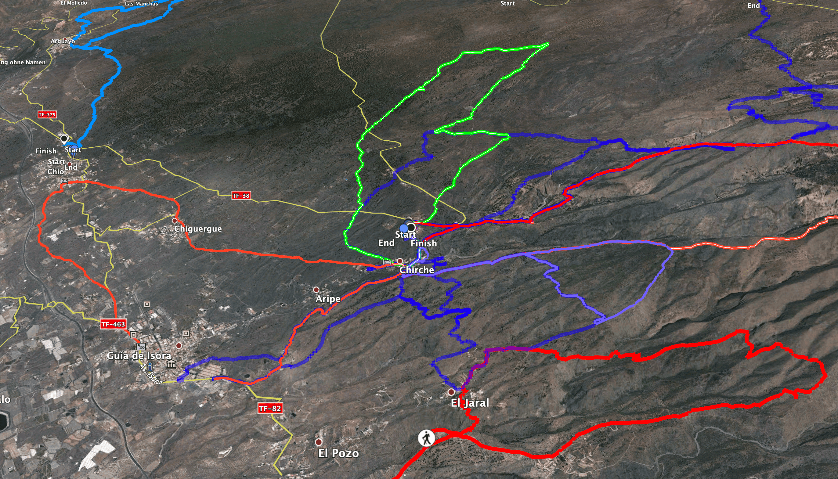
around Chirche you will find many hiking possibilities - here are different coloured tracks
There are many other hikes from Chirche. You can combine the beginning of this hike with a big round hike around the Barranco de Tamuja. On the ridge you return to, you can extend the circuit over El Jaral. There are also cross connections to Chiguerque or further into the western slopes of the Cañadas. You can see some of the hikes in the picture. I will surely publish some more of these hikes near Chirche soon. At the moment there is still the hike through the Barranco de Tagara from Montaña El Cedro. 
High above the Barranco de Tagara towards the fire watch tower - hiking trail with magnificent views towards the Teno Mountains
Hike from Chirche through the Barranco de Tagara
Section Mirador Chirche to ridge path Barranco Tamuja and Barranco de la Corcova
You start your hike at Mirador de Chirche. From here you follow the road down towards Chirche. After a short while, the hiking trail PR TF-70 branches off from the road to the left in the direction of Boca Tauce. Go up a few steps and then follow the trail straight on. It takes you leisurely up a small ridge. You will come quite close to the TF-38 once again, passing gardens, meadows and terraced fields. At the first major junction, keep to the right. Turn left into the Barranco Tamuja (also a very beautiful hike).

View from the ridge path into the gorges to the right (Barranco de la Corcova) and to the left (Barranco Tamuja).
Article summary and large selection of GPS hiking tracks
Sign up for my newsletter now and get exclusive access to my collected GPS tracks as well as all the brief information about my articles.
Sign up nowAfter a short while, the main trail continues straight ahead. However, the PR TF-70 trail turns sharply to the left. It follows a narrow path along a large vineyard. On the other side of the vineyard, the trail then climbs steeply. The path leads you partly on serpentines up to the ridge. From up there you can enjoy a very beautiful view back over Chirche and the surrounding area. After a while, the trail takes you down from the ridge and around the next height. Then it climbs up again to the next ridge. You will follow this to the highest point of the hike.

Junction of the hiking trail to the Barranco de Tagara
Section of ridge trail to junction with the high trail over the Barranco de Tagara
Now comes perhaps the most strenuous part of the hike. It’s all uphill for a very long time. You walk along the ridge between the Barranco Tamuja and the Barranco de la Corcova, which later becomes the Barranco de Tagara. Then you will be compensated for the effort by the magnificent views of the cañadas in front of you, the gorges to the side and the coast of Tenerife behind you. You climb about 1000 metres up the ridge. Then you come to a small junction. Turn left towards Barranco Tamuja. There are many beautiful circular walks there, too, which you can do from the Mirador Narices del Teide, for example.

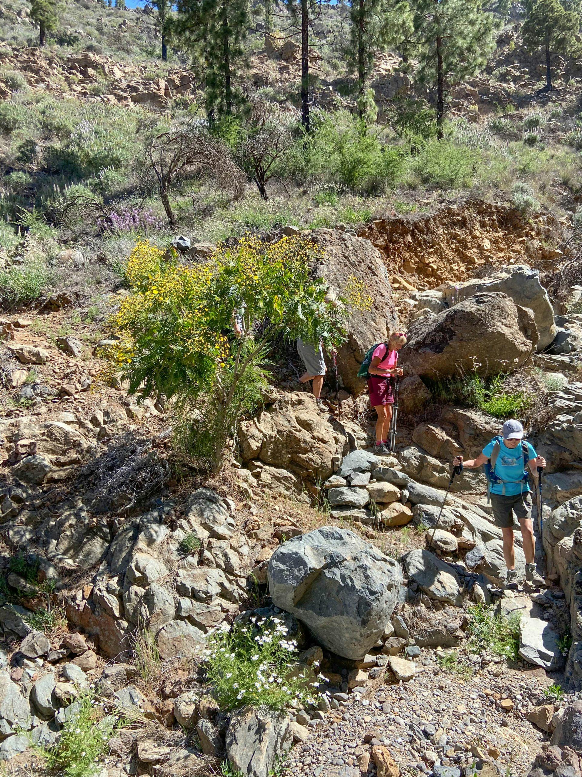
Hiking over fallen tree trunks in the Barranco de Tagara
At this point, however, you go around to the right on a path slightly downhill into the Barranco de Tagara, which you cross for the first time after a short while. The main hiking trail continues around to the right on the other side of the barranco. It is also nice to climb up the barranco in the bed. You can then turn right and return to the main trail via a covered canal. Whether you go up the barranco or the main path, you will eventually be back on the path that leads you up through the forest. After a while (about three switchbacks) you will come to a large fallen tree. The main trail continues straight ahead (see also Montaña el Cedro hike). This takes you up a steep ridge towards the fire watch tower. However, keep to the right on the small path through the forest. 
Narrow path at Barranco Tagara high above Chirche
Junction to the high trail over the Barranco de Tagara to the branch off to the El Jaral hiking trail.
After a short while you will come to a small path, which you now follow around to the left. This leads you along the slope in a large arc, first over the Barranco de Tagara and then over the Barranco El Sauce. The path is more than impressive. You walk high above the clouds with wonderful views. However, a lot of trees have fallen in this area (as of May 2021). They are scattered over the path, so you can only move very slowly because you have to climb over the trees or go around them somehow. You need to be absolutely free from vertigo and sure-footed on this path.

View from above the clouds to the neighbouring islands of La Gomera and La Palma
Eventually you will come to a small junction. The path up to the right leads you to the Montaña El Cedro trail. However, you continue straight ahead. On a ridge you will rejoin the main trail. On the left, TF PR 70.1 continues to Boca Tauce. To the right, go downhill along a covered canal towards El Jaral. Follow this path and the signs downhill for a long time. At first it is a regular hiking trail that leads you steeply down the mountain with beautiful views. After descending a long way, you come to a point where the regular trail branches off to the left to El Jaral. However, you continue straight ahead. 
Crossing Barranco de Tagara
El Jaral trail junction to Mirador Chirche
From now on, the trail gets a little worse, as it descends sharply on rough paths. That’s why I pointed out above that if you want to avoid this, it’s better to do the hike in a different direction. But you can’t miss the path itself. And after a while you will see Chirche lying below you again. You continue on the ridge path and ignore another path that branches off to the left towards El Jaral. Go straight over the village of Chirche and then onto a path that leads you around to the right and directly down into the village.

Hiking trail down to Chirche along water channels
The path will take you to the main street of the village (Calle de los Pinos). Follow this to the right up the hill. If you don’t know Chirche yet, you will now get to see a little of the village. Finally, a path branches off the road to the left, climbing steeply up to Mirador Chirche. One last steep climb and you will reach the road that will take you around to the left and back to the starting point at the Mirador in a short time.

small extension and change - hiking in the Barranco
And finally
I hope you enjoyed this somewhat challenging hike from Chirche to Barranco de Tagara. If the hike is too strenuous for you, you can also visit the Barranco de Tagara from Montaña de Cedro. I have shown you some possibilities for interesting hikes around Chirche. Whatever you decide, I wish you much joy on all your paths, Dagmar from SiebenInseln