Arico – starting point for impressive hiking and climbing tours
The small municipality of Arico with about 8000 inhabitants is located in the southeast of Tenerife. Arico consists of several historical districts. The buildings and streets seem tidy and well maintained, so that a visit to the village in connection with a walk is definitely worthwhile.
Map

El Contador rest area high above Arico
The inhabitants live from agriculture, especially wine growing, self-produced honey and goat farming. Arico is especially popular with active holidaymakers because of the wonderful hiking and climbing possibilities.

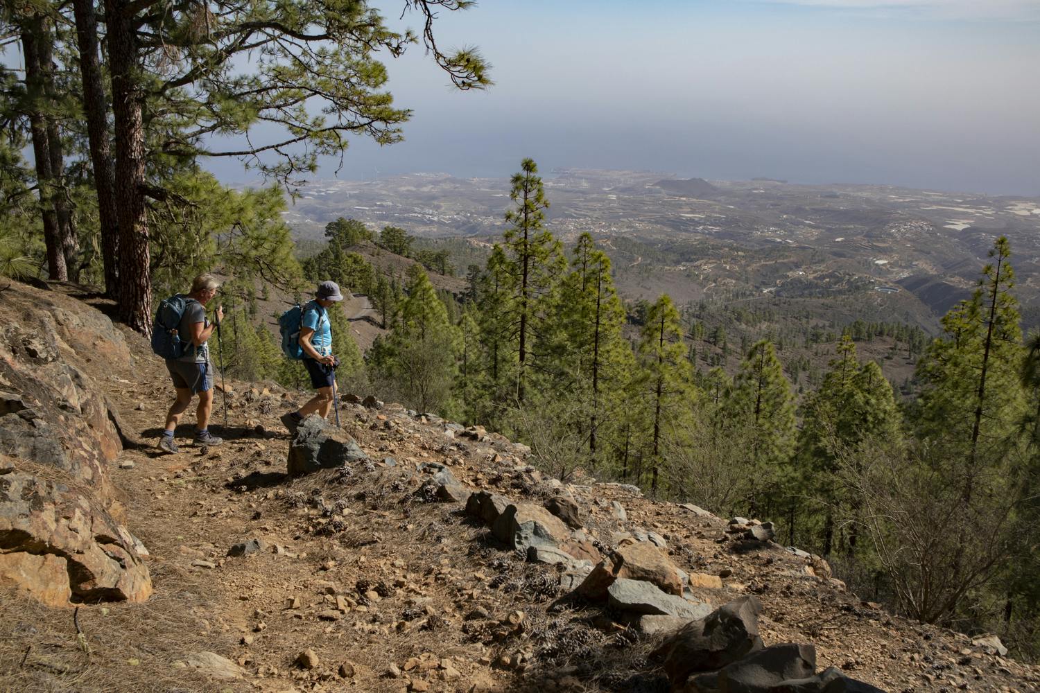
Hiking trail through pine forests with magnificent views
It is interesting to note that the municipal area of Arico extends from 0 metres above sea level (beach level) to over 2500 metres on the eastern slopes of the Cañadas. There are endless hiking possibilities and 100 climbing routes to suit all tastes and requirements. Of course, the view from above is especially good when the sky is clear. From up there you can often look over the whole east coast of Tenerife and also see parts of the south coast and the neighbouring island of Gran Canaria.

PR-TF 86.2 Direction Casa Forestal
Hike high above Arico
The hike I would like to present today starts at an altitude of about 1250 metres high above the small village of Arico. Starting point is the popular rest and picnic area El Contador. Just the approach on narrow field paths to the resting place with wonderful views in all directions is quite impressive. From the rest area El Contador itself there are many possibilities for short or long hikes.

small people - big nature
Today’s hike is therefore only a suggestion that you can shorten, extend and change as you wish. You will always come across the hiking trail PR TF-86 (Mar a cumbre de Arico). This path begins in the village of Arico and then leads via El Contador to the Degollada de Guajara and over to the Caldera del Teide. If you do not want to go that far, the path I have suggested here is a good alternative to enjoy beautiful views and the natural landscape high above Arico.
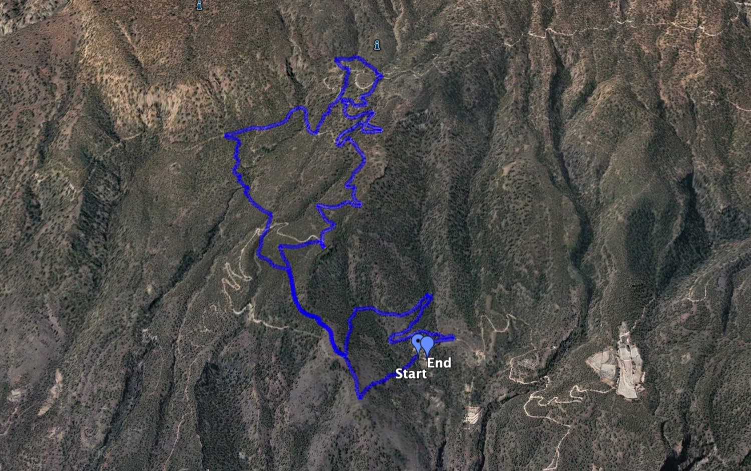
Track hike high above Arico from El Contador rest area
General information about the walk high above Arico
Starting point and approach
The starting point of this hike is the rest and picnic area El Contador (1250 m altitude difference). Coordinates: 28.207224, -16.538644
Arrival by car
Coming from north or south on the TF 1 motorway, take the Arico exit. From there follow the TF 629 to Arico. From the centre of the village, Calle de Calvario leads uphill. The path branches out many times, making it impossible to describe it. You have to keep going uphill or follow the signs to the El Contador rest area. The safest way is to take the starting point with the coordinates: 28.207224, -16.538644. There is ample parking space at the rest area itself.
Arrival by bus
Article summary and large selection of GPS hiking tracks
Sign up for my newsletter now and get exclusive access to my collected GPS tracks as well as all the brief information about my articles.
Sign up nowYou can only get to Arico by bus (see Titsa homepage), so you will need a vehicle for this tour. Time
I don’t like to give general time indications for hiking tours, as the times are very individual. We needed about 4 hours for this tour with some breaks and a longer rest.
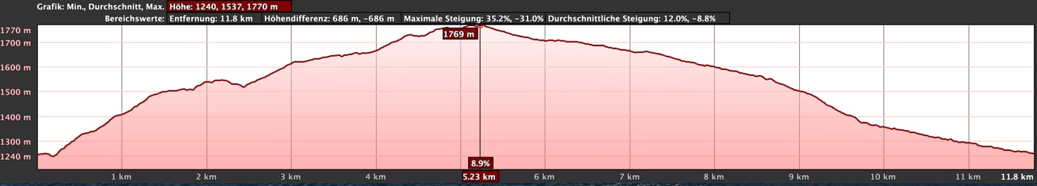
Elevation profile of the circular route high above Arico from El Contador rest area
Difference in altitude and length of the route
The difference in altitude is about 560 metres. The route is about 13 kilometres long.
Requirement
The hike high above Arico is an easy tour and can be done by anyone with a bit of fitness. You hike mostly on well marked and cleaned hiking trails as well as on wide forest and driving paths.
Refreshment
Restaurants, bars and shops can only be found in Arico. Therefore sufficient water and if necessary food – maybe a picnic for the rest area? – take along.
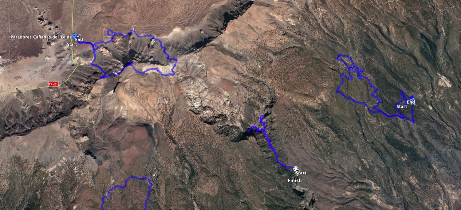
Track Hike over Arico (right) and neighbouring tracks such as Barranco Río i (centre) and Guajara (top left) - but the track itself can also be varied very well
Variants
This tour can be easily combined with many other walks in the area. You can shorten, extend and change the hike high above Arico as you wish. Alone on the track you can see that we have made a small and a big loop, which offers good possibilities for variations.
Two more hikes near Arico and around the Barranco Tamadaya can be found here. 
Starting point of the hike - resting place El Contador high above Arico
Hike high above Arico from the El Contador rest area
Route section El Contador rest area to the crossroads
You start the hike high above Arico at the resting place El Contador. Around the resting place is the road on which you came up from Arico. From the centre of the rest area, a path leads uphill in a southerly direction (PR TF-86.2 towards Casa Forestal). Follow this path. The path will take you through the forest. However, the higher you climb, the more the forest thins out. Looking back, you can already enjoy the first good views of the east coast of Tenerife.

View down to the east coast of Tenerife
Article summary and large selection of GPS hiking tracks
Sign up for my newsletter now and get exclusive access to my collected GPS tracks as well as all the brief information about my articles.
Sign up nowAfter a steep ascent you will reach a bare plateau. Here the hiking trail branches off to the right. You continue climbing for a while and then come back to the road. On the way back, turn right. Now cross the road and keep going straight uphill. The path is not to be missed. It takes you partly over barren plains and then uphill again through wooded areas. You walk until you reach a crossroads.

uphill on narrow paths
Section of the trail Hiking crossroads to the highest point of the hike
At this junction there is a signpost to Casa Forestal. But you do not follow these signs, but turn left. You continue walking uphill for a long time until you meet the road again. You cross the road and continue walking uphill. Also at the next fork you keep left. Keep going straight on and cross two small gorges. Finally you will come to a road again. Follow the road to the right for a while.

big tree by the wayside
Then a path branches off to the left. You now walk up this path. Cross the road four more times, but keep going straight ahead. You can also follow the driveway upwards. We have made another turn here and then we hiked downhill again at an altitude of a little under 1800 metres. Here you can also vary and go up higher or, if necessary, go down.

Forest path with views of the east coast of Tenerife
Route section highest point of the hike to Casa Forestal
As you can see on the track, we first descended on a narrow path. Then we came back on the track. We continued left on the track and took some serpentines. If you keep to the right and after a short time leave the track to the right onto a path, the track is a little shorter. Both ways come together again. Shortly after the path (shortcut) meets the footpath again, the road forks and you turn left.

Viewpoint at the Casa Forestal
From here you follow the path further downhill for a long time, mostly through pine forest. Finally, you will pass a large closed house (Casa Forestal). From here you will have another great view of the entire slopes, the coast and the far Atlantic Ocean. This place is also ideal for a rest.

View of the back of the cañadas
Route section Casa Forestal to rest area El Contador
You go back on the road, which you leave to the left after a short time. The path takes you back to the crossroads where you went up on the left on the outward path. Now you go straight on downhill. For a short time this is exactly the way you came. When you reach the next road, however, turn left. On the outward path you have come straight up.

Hiking trail over plateaus and through pine forests
The road will take you in a sweeping arc through the pine forest down to the El Contador rest area. To get to the starting point of the walk, you will have to go round the rest area almost once. If you have not yet had time to take a break or rest, this is the last chance to enjoy this tranquil place.

View over the slopes of the east coast of Tenerife
And finally
I hope you enjoyed this hike high above Arico. As you can see on the track and on the map, the area around the El Contador rest stop offers many possibilities for hiking. Interesting are the rest area, the view from Casa Forestal and the beautiful views from the top. How you combine all this is up to you. In any case, I wish you lots of fun on all your hikes,
Dagmar of SiebenInseln