The path from Mirador Corona to Chanajiga is closed (as of 4.1.2025) because a few hundred metres before Chanajiga there are a lot of loose trees on the slope. Current information on this in the TenerifeOn app.
Well-known hiking trail from Los Realejos to the Chanajiga rest area
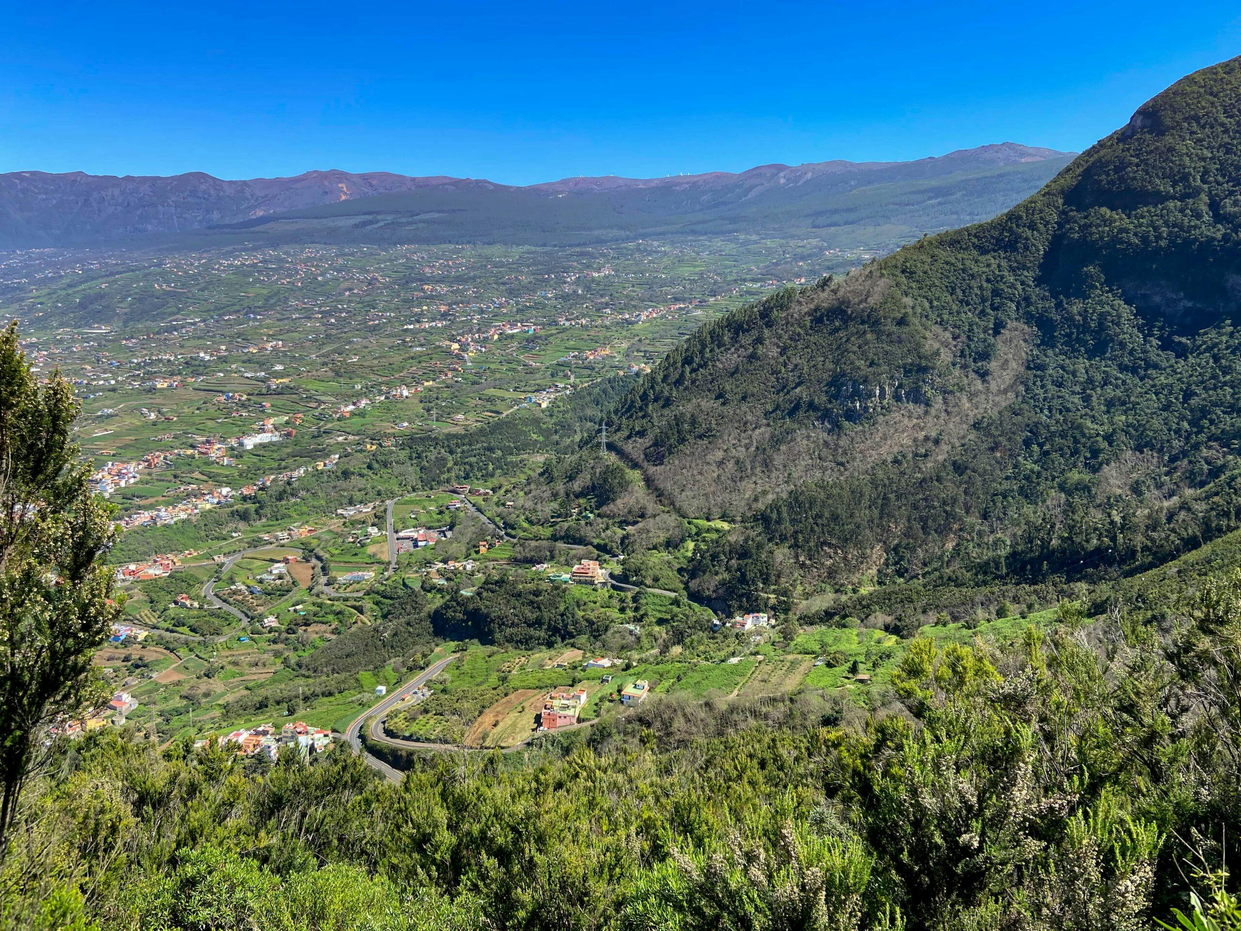
This really attractive and beautiful circular walk takes you to the large rest area of Chanajiga in the western Orotava valley. You start above the small village of Icod el Alto at the Mirador de La Corona. This is also where the paragliders take off for their flights over the wide valley. From the Mirador de La Corona, the trail climbs steeply up to the Mirador El Asomadero and from there to the Area Recreativa de Chanajiga.
Map

View of the Teide from the hiking trail above Mirador Corona
But you are not only on a beautiful hiking trail, but also on the well-known trail route 0.4.0, which runs from Playa de El Socorro in Los Realejos via hiking trail PR-TF 41 up to the Teide. If you feel fit, you can walk 27 kilometres on this trail from 0 to 4000 metres altitude in one day. It is guaranteed that such a trail is not suitable for everyone. But if you hike between Los Realejos and Chanajiga, you will always meet runners who seem to accept this challenge.

Waymarking - Route 0.4.0 from Playa Los Realejos to Teide
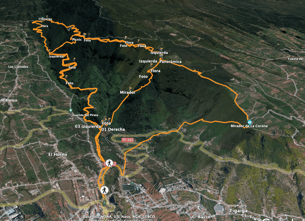
Hiking trail from the Mirador de La Corona via Chanajiga and Los Realejos
The first part of the hike to Chanajiga leads you through dense laurel forest with magnificent views of the Orotava valley. The way back is very varied. You hike through forest, but later also through meadows and fields. In Los Realejos, you then walk along paths, a barranco and across the road back to the steep ascent path.

Hiking trail on the slope to Chanajiga
On the final ascent, you can once again enjoy magnificent views over the entire north coast. As this is a quite strenuous hike with some metres in altitude, I will also show you some possibilities to shorten the hike a little.
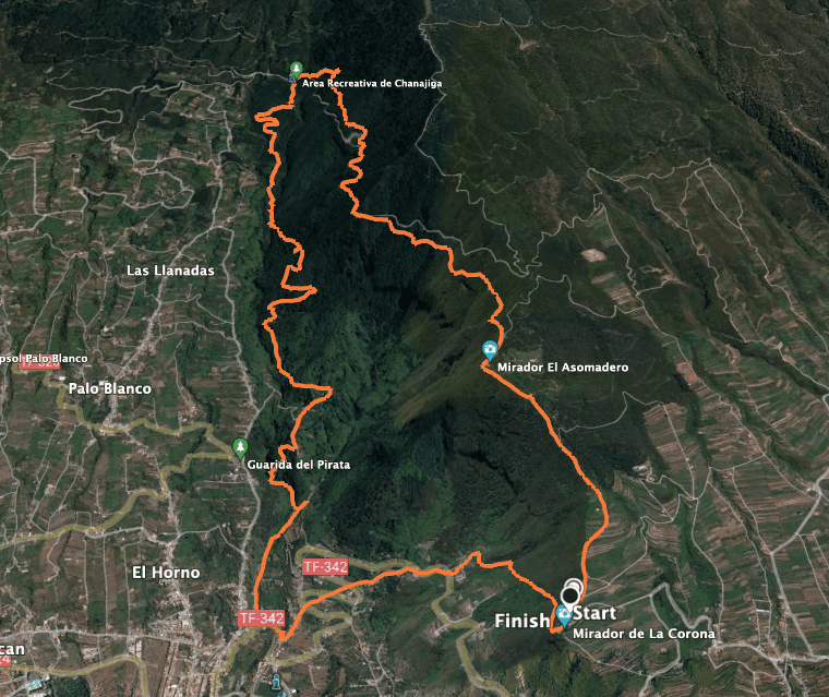
Track Circular Chanajiga - Los Realejos - Mirador Corona
General information about the Chanajiga picnic site hike
Starting point and approach
The starting point of the hike is the Mirador de la Corona above Icod el Alto.

Starting point Mirador Corona with a view of Teide
Arrival by car
From the north, take the TF-343 via Los Realejos and the TF-342 to Icod el Alto. From there, turn left up to the Mirador de La Corona. Coming from the west/south, take the La Guancha exit and then take the TF-342 towards Icod el Alto. Before you reach the village, turn right up to the Mirador de La Corona.

at the Mirador Corona
Arrival by bus
You can take the Titsa bus 354 to Icod el Alto. From there you can take a taxi to Mirador de La Corona or climb up. You can find more information on the Titsa homepage. Article summary and large selection of GPS hiking tracks
Sign up for my newsletter now and get exclusive access to my collected GPS tracks as well as all the brief information about my articles.
Sign up nowTime
I don’t like to give general times for hiking tours, because the times are very individual. We needed just under 6 hours for this hike with an extensive rest.
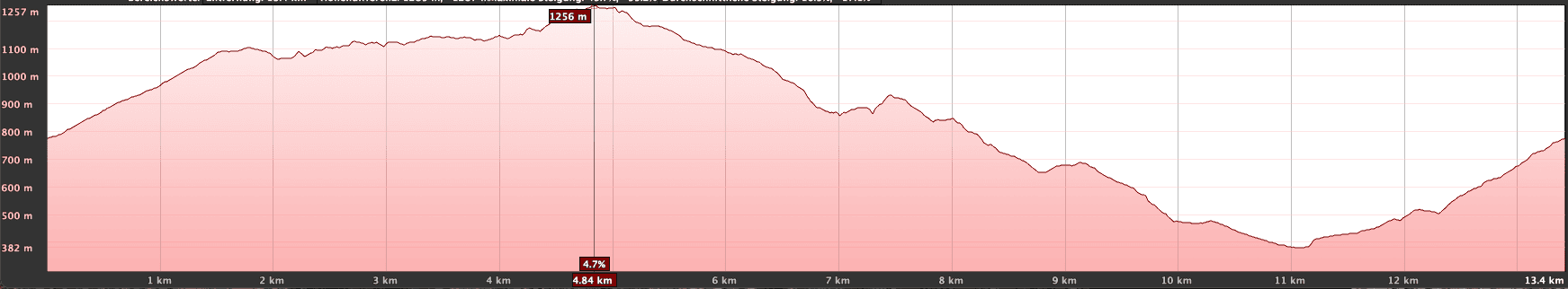
Altitude profile of the Circular Chanajiga - Los Realejos - Mirador Corona hike
Altitude difference and route length
The difference in altitude is about 1100 metres and the route is about 16 kilometres long.
Requirement
This hike follows well-marked and excellent hiking trails. But because of the length and the more than 1000 metres in altitude, it should not be underestimated. You must be in good physical condition.
Refreshment
There are no restaurants, bars or shops along the entire route. Unless you deviate from the hiking trail and enter the town of Los Realejos. Therefore, take enough water and food with you if necessary.
Circular track with possible crossings Chanajiga - Mirador Corona. Los Realejos
Variants
This tour can be easily combined with various other hikes and circular walks in the vicinity. Especially at the Chanajida hiking junction, you will find countless hikes that run in all directions. If you want to hike further and higher, there are no limits on the PR TF-41. Another tour from Chanajiga to Fortaleza in the Cañadas can be found here. 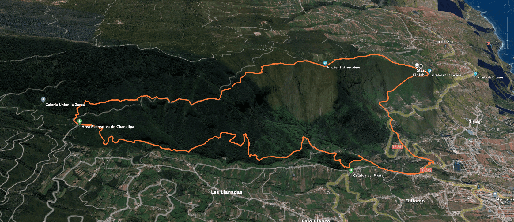
Track Circular Chanajiga - Los Realejos - Mirador Corona
You can continue all the way to Teide. If you prefer a smaller loop, you can see two cross connections between the ascent and descent paths on the track image. If you use them, you won’t get to Chanajiga, but you can significantly reduce your loop above the Orotava Valley.

Clouds over the valley, but still a great view - on the way to Chanajiga
Hike around Mirador de La Corona – Chanajiga – Los Realejos
Mirador de La Corona to Mirador El Asomadero section
You start your hike at the Mirador de La Corona. From here you take the wide PR TF-41 path, marked yellow and white, uphill towards Mirador El Asomadero. The path leads you mostly along the slope, so that you can enjoy beautiful views of the Orotava valley from the beginning. But then the path becomes narrower and steeper and leads you through woodland. After rainfall, it can be quite muddy.

Hiking signs TF 41
You cross a road in a bend. The trail then continues steeply uphill. On the right, you will pass the Fuente de Pedro. After a hard climb, you will finally reach the Mirador El Asomadero. Here, at an altitude of 1093 metres, you can enjoy a great view over the Orotava valley and study the information boards. If you have already hiked enough, you can take the very steep PR TF-40 down into the Barranco de La Calera to Realejo Alto.

View from the hiking trail ridge down into the valley and up to the Cumbre Dorsal of Tenerife
Article summary and large selection of GPS hiking tracks
Sign up for my newsletter now and get exclusive access to my collected GPS tracks as well as all the brief information about my articles.
Sign up nowRoute section El Asomadero to Chanajiga rest area
You now continue on the PR TF-40 in the direction of Chanajiga. After a while, the well-known trail 0.4.0 branches off to the right towards Teide. However, you continue through the dense forest on beautiful paths along the mountainside. After about half an hour, you reach the Risco Miguel viewpoint with the Choza Enrique Talg refuge at 1145 metres altitude. Here, another cross trail PR TF 40.1 goes down into the barranco.

Information board at El Asomadero - also about the well-known Trail Route 0.4.0
There it meets our descent path. This gives you the opportunity to reduce the loop a little. Shortly after Risco Miguel you can follow the track or the hiking trail, which often run parallel through the slope. I always chose the hiking trail for both options. Finally, at an altitude of 1185 metres, you reach the Chanajiga rest area via a playground. Here you have time for a long rest before starting the way back.

Risco Miguel - Shelter and Mirador
Chanajiga rest area to Realejo Alto section
From the Chanajiga rest area, you can follow PR TF-40 downhill on the other side along a wide path. Alternatively, you can shorten a few loops by following a small path downhill below the rest area. This will bring you back to the main trail after a short while straight downhill. You can see this clearly from my track. On the main path you then continue downhill in large serpentines through the forest. First the path runs along a small ridge and then along the mountainside.

Chanajiga rest area
After a short while, PR-TF 40.1 branches off to the left, which – as mentioned above – leads up to Risco Miguel and can shorten the loop for you. For the big loop, however, continue straight down through the forest. On the way down, you will pass the Fuente del Til and then descend through the laurel forest (Til de Los Pavos). The trail continues for a long time through the forest along the slope above the Barranco de la Calera. Finally, you reach the first houses and fields of Realejo Alto.

View of Los Realejos from the hiking trail
Realejo Alto to Ascent Trail Section
From the paved path near the houses in Realejo Alto, the trail then goes again into a small side barranco of the Barranco de la Calera. This takes you through green meadows past caves down into the Barranco de la Calera. You cross the Barranco Grund. Then a track brings you to a small road. Follow the road around to the right for a while. Finally, go down from the road to the left into the green grass of the barranco. On the other side of the barranco you climb up again.

Hiking trail between Chanajiga and Los Realejos
Now you are on TF-342, which you have to follow uphill for a while. Because someone let us cross their property, we were able to shorten a big curve. But normally you have to follow the road a bit and go on for a few bends. Then the hiking trail to the Mirador de La Corona starts on the right side, signposted. The hiking trail runs straight and shortens all further serpentines of the road. You will cross the TF-342 a few times and then reach the actual ascent path.

Barranco crossing near Los Realejos
Ascent route section to Mirador de La Corona
After crossing the TF 342 one last time, take the wide Madre Juana path towards a small hamlet. Just before you reach the houses, the trail to the mirador branches off on the left. It is quite steep and takes you quickly up through the forest. On the mountain slope, you walk up on shady forest paths towards the Mirador de La Corona. In between, you can enjoy beautiful views back to Realejo Alto and the entire Orotava valley.

Hiking trail near Los Realejos
And finally
II hope you enjoyed this beautiful circular hike in the Orotava Valley, which you can do in many different ways. Maybe you are so sporty that you would like to try out Trail 0.4.0 right away. I will soon present another hike from Chanajiga to Fortaleza here on Seven Islands. Until then, I wish you lots of fun on all your hikes,
Dagmar from Siebeninseln