Hike from Oratava Valley to Fortaleza Cañadas on Trail 0.4.0
I recently described a hike in the western Orotava valley from the Mirador de La Corona to the Chanajiga rest area here on Seven Islands. Practically seamless with this hike, the hike continues over the Ladera de Tigaiga up to the Fortaleza in the Cañadas. For this tour, you hike from the shady forests of the western Orotava valley up into the barren white lunar landscape of the Cañadas. Map

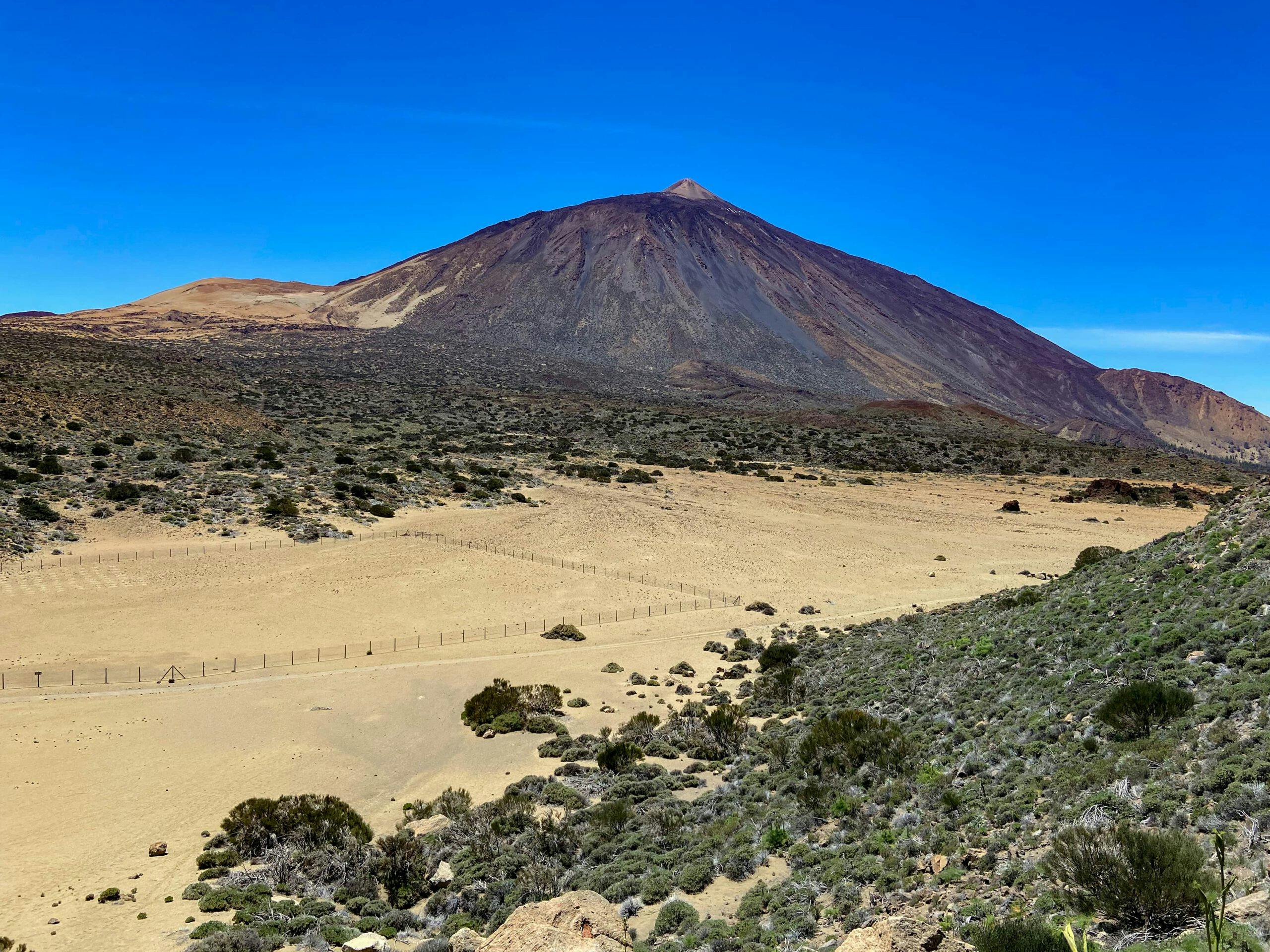
View of the Teide from the hiking trail
On the hike to Chanajiga, I described the well-known Trail 0.4.0, which leads from the beach below Los Realejos to the Teide. If you have done the hike from Mirador de La Corona, you have hiked parts of this trail. Now you will meet this trail again on the hike to Fortaleza in the Cañadas. The outward route takes you to Fortaleza in the Cañadas on this well-known trail. 
View from the summit plateau of Fortaleza to Teide
Great strenuous circular hike with impressive views
On this great circular hike from Chanajiga to Fortaleza in the Cañadas, you hike uphill on good hiking trails. At the top, you can take a trip to the large plateau of Fortaleza. From there you have a fantastic view over the Cañadas, the Montaña Blanca and the Teide. You will also be able to see the entire Cumbre Dorsal and the neighbouring islands of La Gomera and La Palma. The way back is on forest tracks and smaller paths.

Hiking trail 29 marked yellow white
Here I will show you several alternatives. Depending on whether you prefer steep mountain bike trails or rather wide roads. But let me say in advance that this hike is quite strenuous, with over 1,100 metres in altitude and a length of just over 16 kilometres.
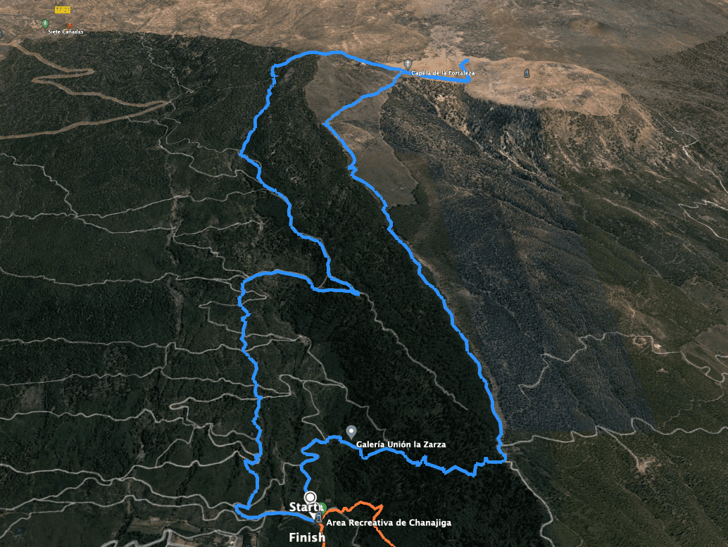
Chanajiga to Fortaleza Hike Track in the Cañadas
General information about the Chanajiga – Fortaleza Cañadas hike
Starting point and approach
The starting point of the hike is the Chanajiga rest area.
GPS Data: 28.343943, -16.584473

the Chanajiga rest area - starting point of the hike
Arrival by car
The approach is easy from the TF-5 via Los Realejos and then via the TF-326 to Palo Alto and Las Llanadas. From there, it continues for a few kilometres on a well-signposted road to Chanajiga. The way there is a little difficult to describe in detail. Therefore, you can either use the GPS data or look for the Chanajiga rest area on the internet. There are plenty of parking spaces on site.
Arrival by bus
There is a bus connection with the Titsa bus line 330 only to Las Llanadas, so you would have to walk a few kilometres from there to Chanajiga. Details can be found on the Titsa homepage. Time
Article summary and large selection of GPS hiking tracks
Sign up for my newsletter now and get exclusive access to my collected GPS tracks as well as all the brief information about my articles.
Sign up nowI don’t like to give general times for hiking tours, because the times are very individual. We needed about 5.5 hours for this hike with an extensive rest at the summit.
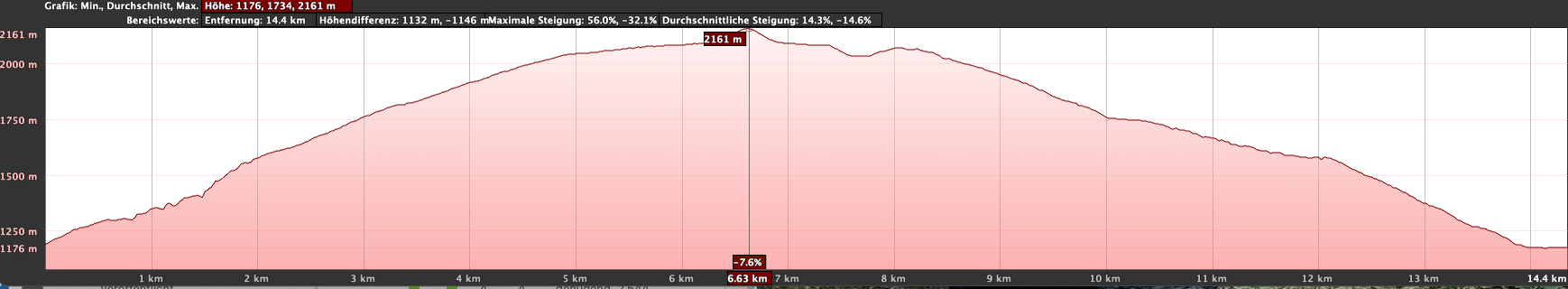
Altitude profile of the Chanajiga - Fortaleza Cañadas hike
Altitude difference and route length
The difference in altitude is about 1,100 metres and the route is just over 16 kilometres long.
Requirement
Basically, this hike is classified as difficult in my opinion because of the metres in altitude to be overcome and the total distance. The outward route is on good hiking trails. On the way back, you will find a choice of roadways or steep paths (mountain bike trails).
Refreshment
There are no restaurants, bars or shops along the entire route. Therefore, take enough water and, if necessary, food with you.
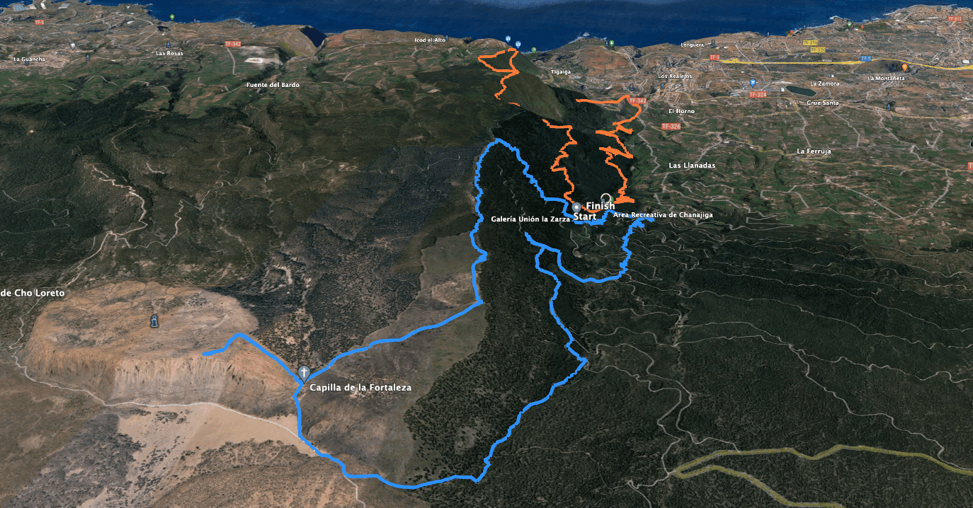
Tracks of the hike Mirador de La Corona to Chanajiga (orange) and Chanajiga to Fortaleza in the Cañadas (blue)
Variants
This tour can be easily combined with various other hiking tours and circular walks in the vicinity. The Mirador de La Corona – Chanajiga hike is directly adjacent to this tour. From Fortaleza in the Cañadas, you can also continue to El Portillo and return by bus. If you are really sporty, you can also follow Trail 0.4.0 and walk up Pico del Teide. Furthermore, from Fortaleza you will find the adjacent tour from El Portillo to Montaña Blanca. If you don’t want to follow this circular hike, you can of course hike back from Fortaleza to Chanajiga along the same route.

White expanse - Fortaleza Cañadas Teide
Chanajiga Circular Hike to the Fortaleza Cañadas
Chanajiga to Piedra de los Pastores section
You start your hike at the Chanajiga rest area. In the middle of the rest area there are steps leading uphill. Follow these steps. On the hiking trail that runs between the picnic tables, after a while you will come up through the forest to a road. Follow this to the right. At the third bend, turn right off the road onto a small path. Now cross the Barranco de la Calera on a narrow path. After a short while, you will pass the Galería Unión la Zarza on this crossing.

Hiking trail near Chanajiga through the barranco
From here you can look back over the entire Orotava valley. Continue uphill through the forest in steep switchbacks on the PR TF-41, marked in yellow and white. After about half an hour, you will reach a forest road. Follow this to the left and in about 100 metres you will come to the signposted Piedra de los Pastores. There was no longer a shelter here in April 2022, but it is a kind of resting place. The forest road on the right leads further into the Cañadas. However, you continue straight ahead on the hiking trail.

Choza Piedra de los Pastores
Route section Piedra de los Pastores to Fortaleza Cañadas Chapel
Follow the yellow and white PR TF-41 and trail 0.4.0 towards Pico del Teide. The hiking trail now leads you along the ridge for quite a while. You climb uphill alternately on the narrow hiking trail through the forest and on the parallel road towards Cañadas. To the right you already have wonderful views of the Teide. Finally, you only walk uphill on the road. Then leave the forest behind you. Down in the valley on the right, you will see a forester’s lodge, which you pass. Some tracks branch off to the right of the road. Follow the signs to Pico del Teide mentioned above.
Article summary and large selection of GPS hiking tracks
Sign up for my newsletter now and get exclusive access to my collected GPS tracks as well as all the brief information about my articles.
Sign up now
Barrier at the beginning of Teide National Park
A road barrier, which you can pass on a path, marks the beginning of the Teide National Park. Now you can see not only the Teide but also Fortaleza in the Cañadas in front of you. The trail branches off from the ridge in a right-hand bend. From now on, follow the slope towards Degollada de Cedro. At the end of the slope, you will reach the Degollada de Cedro. This is a saddle between the Fortaleza and the Cabezón. Here you will find a chapel (Cruz de Fregel) and a crossroads.

Small chapel below Fortaleza Cañadas with hiking junction - continue on Teide or climb Fortaleza
Route section Degollada de Cedro via Fortaleza to junction with TF-21
On the right, the S-36 trail takes you up to the back of Fortaleza in 1.2 kilometres. You should not miss this. After the short climb, you can enjoy fantastic views of the neighbouring islands of La Gomera and La Palma from up there. You will see the Cañadas, the Montaña Blanca, the Teide and the Cumbre Dorsal. Below you, a seemingly white lunar landscape lies at your feet. Do you feel like a rest on the summit? This is the ideal spot. The „lagartos“ are already waiting for some crumbs to fall off your snack.

View from Fortaleza Cañadas towards El Portillo
When you have seen and rested enough, take the same path back down to the chapel. From there, turn left and follow the descent path PR TF-41 or trail 0.4.0 and trail S-29 towards El Portillo. At the bottom, follow the main trail to the left towards El Portillo. You hike slightly uphill along the foot of the Cabezón. After a short while you will come to a junction. Now leave the main trail and follow the S-25 in the direction of TF-21.

Large "lagartos" along the way
Route section TF-21 to Chanajiga
First, after the crossroads, walk slightly downhill and then cross the final spur of the Cabezón. This will take you to the other wooded side of the mountain. There you stay on the main path for the time being. After a short while, however, an inconspicuous narrow path branches off to the left.

Branch off small path from the hiking trail down through the barranco towards Chanajiga
It is marked by two stones. Follow this path down through the Barranco de la Zarza. The path is easy to find and you are surrounded by green bushes and plants in the barranco. At the end of the path you will finally reach a track, which you follow for quite a while on the slope to the left. Here on the track, hiking is easy and you can enjoy wonderful views.
You ignore two tracks that branch off to the right. But you follow the third track branching off to the right and hike further down the slope. After a short while, a small path branches off to the left, which looks more like a gully.

View from the road back to the cloud cover over the Orotava valley
From now on you have two options:
- 1.0
If you prefer to take it easy, you can continue to follow the track, which takes you down in sweeping serpentines towards Chanajiga. This way is safe, but still a few kilometres longer than the straight road.
- 2.0
On a very straight path, you can follow the gully downhill. In parts it is very passable, in others it is quite difficult to walk because of the many stones. It seems that this gully is also used a lot by mountain bikers. On the track you can see that I took this path, but I really can’t recommend it for everyone.

Junction path S-25 direction Chanajiga
Whatever you decide here, you can’t miss the way back to Chanajiga from here. Even on the straight path through the gully, you will eventually get back to the track that you have crossed several times. Turn left and you will soon return to the starting point in Chanajiga.

View of La Palma from above
And finally
II hope you enjoyed this interesting circular walk across the Fortaleza in the Cañadas. On the way back, you will come across many hiking and driving trails, so that you can easily put together your own tour in addition to the variants I have suggested. Whatever you decide, I hope you enjoy your hike.
Dagmar from Siebeninseln