This large hiking tour starts in the small village of Barranco Hondo on the east coast of Tenerife. The village takes its name from the gorge of the same name along which it lies and which cuts it in half. The hike takes you along old water channels on the eastern slopes of the mountain with magnificent views of the coast and the neighbouring island of Gran Canaria. You will pass the Ermita del Rosario chapel, from whose forecourt you can see far over the nearby capital Santa Cruz de Tenerife to the Anaga mountains.
At the Barranco del Rosario, you will walk uphill in an open area between green meadows and fields, through the small settlement of Las Barreras. The trail then leads you into the wild and dense Esperanza forest. You hike around the Área Recreativa Las Raíces until you almost reach the mountain road TF-24. Then you go up and down through the forest and some ravines to the Barranco Hondo. You cross the deep gorge and then hike along the edge of the Barranco Hondo back down to the village of the same name. This round tour is a really interesting and varied hike.
Track of the Barranco Hondo circular hike
General information about the Barranco Hondo hike
Starting point and route
The starting point of the hike is the small town of Barranco Hondo on the upper Camino Suarez – 28.403216, -16.358875.
Approach by car
You reach Barranco Hondo via the TF-1 and take the Barranco Hondo exit. Then take the TF-287 and TF-28 up to the town. Continue uphill until you reach the centre of the village near the Iglesia Barranco Hondo. Here, at the top of the village, you will come to Calle Suarez, which crosses the Barranco Hondo. There you can park on the road and start the hike.
Approach by bus
Titsa buses 122 and 142 go to Barranco Hondo. The bus stop is on Calle la Capilla. From there you can walk to the starting point of the walk in a short time. More information is available on the Titsa homepage.
Time
I don’t like to give general times for walking tours, as the times are very individual. We needed 4 hours 30 minutes for this round tour with a longer rest.
Altitude profile of the Barranco Hondo circular hike
Article summary and large selection of GPS hiking tracks
Sign up for my newsletter now and get exclusive access to my collected GPS tracks as well as all the brief information about my articles.
The difference in altitude is just under 780 metres and the route is just over 12 kilometres long.
Requirements
You hike mostly on good roads and hiking trails. In the Esperanza forest, when crossing the Barranco Hondo and on the way back, you will come across narrower paths from time to time.
Refreshments
You will only find refreshment stops at the starting point in Barranco Hondo. Therefore, please take enough water and, if necessary, food with you for the hike.
Track of the Barranco Hondo hike (red) and adjacent loop through the Esperanza Forest (blue)
Variants
Directly adjacent to this hike in the upper part is a hiking loop in the Esperanza Forest – Las Raíces Tour. A very short section is even identical to this hike. Therefore, both hikes can be combined very well.
Hiking trail with a view back to the village of Barranco Hondo along the canal
Hike Barranco Hondo
Barranco Hondo to Ermita del Rosario section
You start your hike in the upper part of the small village of Barranco Hondo in Calle Suarez. There you will find signs for the Camino Viejo de Candelaria SL TF 301, which you follow out of the village towards Ermita del Rosario. After a short time on the road, the hiking trail branches off to the left of the road at the water channels. Afterwards, you hike at a constant altitude and slightly up and down parallel to old water channels. The trail offers wonderful views of the east coast of Tenerife, the neighbouring island of Gran Canaria and back to the village of Barranco Hondo.
Start hiking trail round Barranco Hondo and trail to La Laguna
You cross several gorges, such as the Barranco de las Moradillas. After two kilometres past Barranco Hondo, you reach the Ermita del Rosario. From its forecourt, the view that stretches beyond Santa Cruz de Tenerife to the Anaga Mountains is worthwhile. You can continue straight on along the road to La Laguna. However, cross the road at the Ermita and from there follow the hiking trail SL TF 301 uphill towards Las Barreras.
Article summary and large selection of GPS hiking tracks
Sign up for my newsletter now and get exclusive access to my collected GPS tracks as well as all the brief information about my articles.
Ermita del Rosario - good view of the east coast of Tenerife - here the hiking trail branches off to the left uphill at the Barranco del Rosario
Section Barranco Hondo to Ermita del Rosario to Zona de Acampada De Las Raíces
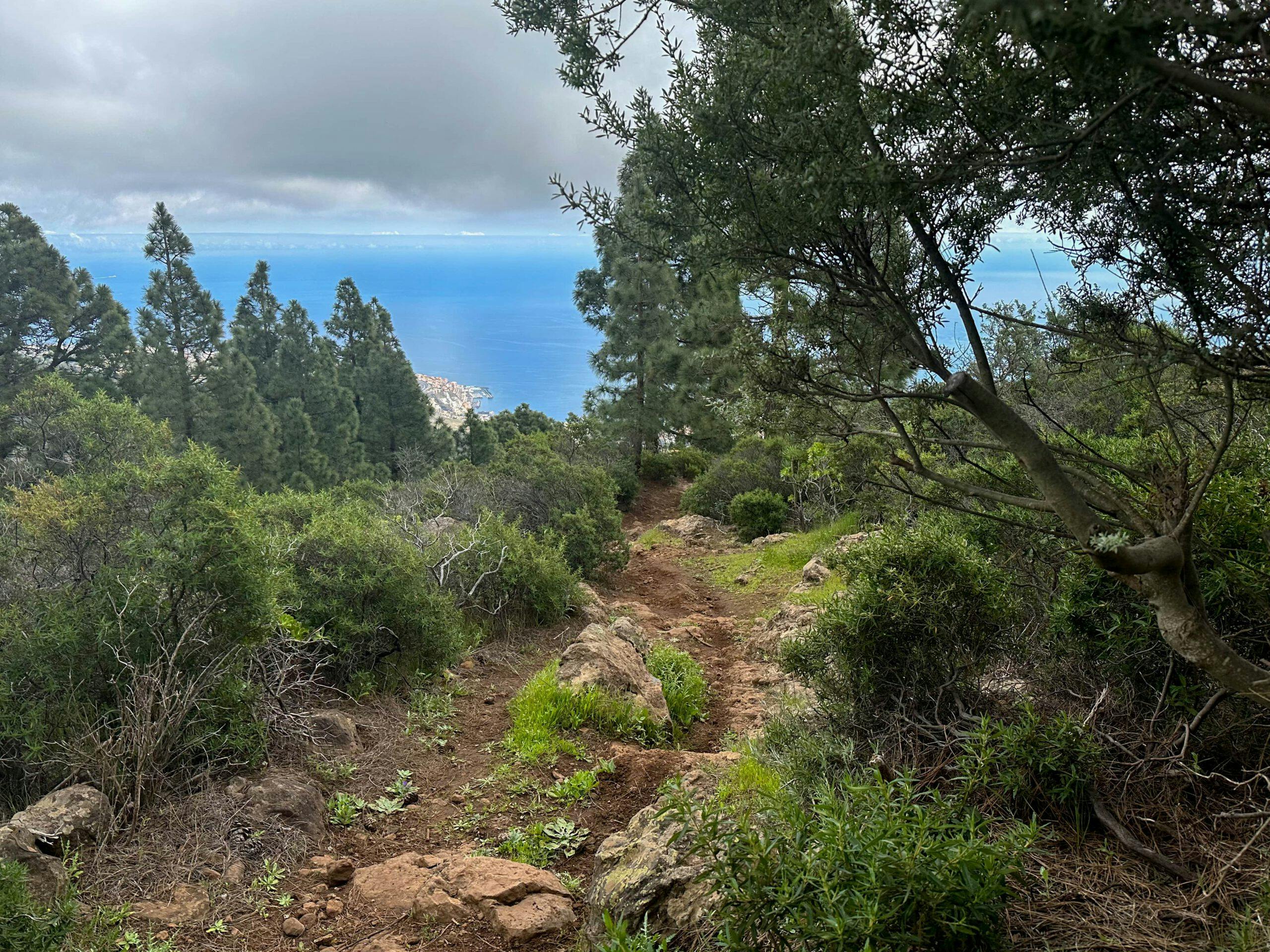
From now on, you climb uphill along the right edge of the Barranco del Rosario. The trail takes you past fields and meadows. After a while, you will cross the gorge to the left as you continue your ascent. The ascent continues and after a while crosses a water channel. The views are fantastic. After climbing for a while, you will reach the small village of Las Barreras. There, the trail turns into a small road that you follow straight uphill through the village for a very long time. Finally, you will leave the village on this uphill road, which also marks the beginning of the forest.
Ascent trail at Barranco del Rosario
After a while, the road bends to the right. There you take the hiking trail to the left through the forest. You walk uphill through the Esperanza forest for quite a while. Finally, the trail joins a dirt road. On the left, the track leads to the Área Recreativa Las Raíces. However, you hike around the road to the right. After a short while, a narrow path branches off to the left uphill. For a short time, you will climb steeply through the forest. This path finally brings you back to a track and a hiking trail running parallel to it. Turn left on the track or hiking trail to the Zona de Acampada De Las Raíces.
Hiking trail at Las Barreras
Section Zona de Acampada De Las Raíces to the starting point Barranco Hondo
This small section is identical to the circular hike Las Raíces Tour. At the Las Raíces campsite, continue straight on towards Barranco Hondo. The trail goes slightly uphill and downhill on small footpaths. You will cross several gorges. Finally you reach the Barranco Hondo. A narrow path leads down into the gorge, which you cross.
Hiking trail through the forest
On the other side, the path goes uphill again. After the ascent, you will reach a small settlement with many large open spaces. From there, a wide path leads downhill, which you follow. It runs parallel to the Barranco Hondo. After a while, the path becomes narrower and sometimes steep. But overall it is a nice descent path that takes you straight down parallel to the gorge.
Crossing of the Barranco Hondo
Just before you reach the village of Barranco Hondo, you will come to the Camino Lomo el Pájaro road. This will take you further downhill and into the village. You walk in an arc downhill near the church. Then you come to the Barranco Hondo, which you can cross on a hiking trail or on the road. Then continue on the road until you get back to your starting point.
View of the village of Barranco Hondo from the descent path
And finally
I hope you enjoyed this varied circular walk in the village and to the Barranco Hondo gorge. I think it is quite varied because of the small town, the large gorge, the Esperanza forest and the beautiful views. But decide for yourself. In any case, I wish you lots of fun on all your hikes,
Dagmar from Siebeninseln
Thank you for reading!
If you've found my hiking guides on SiebenInseln helpful for your Canary Islands adventures, please consider leaving a small tip. Your support is greatly appreciated and helps cover the costs of maintaining this blog.
Thank you for your support!
SSL secured
Comments
Volodymyr - 11/28/23, 04:40 PM
Did it today. All trail is accessible today but I think you should wait some time until forest recovers at least a little after the fires. The trails PR TF 25.1 and PR TF 25 are completely burned out and it’s just painful to look at all this if you saw this forest in its original form. Many private gardens that were in the path of the fire were damaged. Officially the paths PR TF 25.1 and PR TF 25 are closed, but there are no tapes or barriers. There are many campers with tents in the recreation area.