Las Lagunetas Protected Landscape above Igueste de Candelaria
When you start walking from Igueste de Candelaria, you are already in the protected landscape of Las Lagunetas. This landscape is a mountainous forest area that plays an important role in the conservation of underground groundwater and soil protection. There are large areas of pine forest and also so-called Monteverde (Laurisilva and Fayal-Brezal), as well as many other endemic tree and plant species.
Map
Hiker on the descent path in the protected area of La Lagunetas in the forest towards Igueste de Candelaria
With an area of 3,800 hectares, the protected landscape of Las Lagunetas includes the municipalities of Candelaria, El Rosario, El Sauzal, La Matanza de Acentejo, La Victoria de Acentejo, Santa Úrsula and Tacoronte. The municipality of Candelaria also includes the village of Igueste de Candelaria. In addition to these protected tree giants, you will also hear and hopefully see canaries, blue finches and blackbirds.
Hike from Igueste de Candelaria
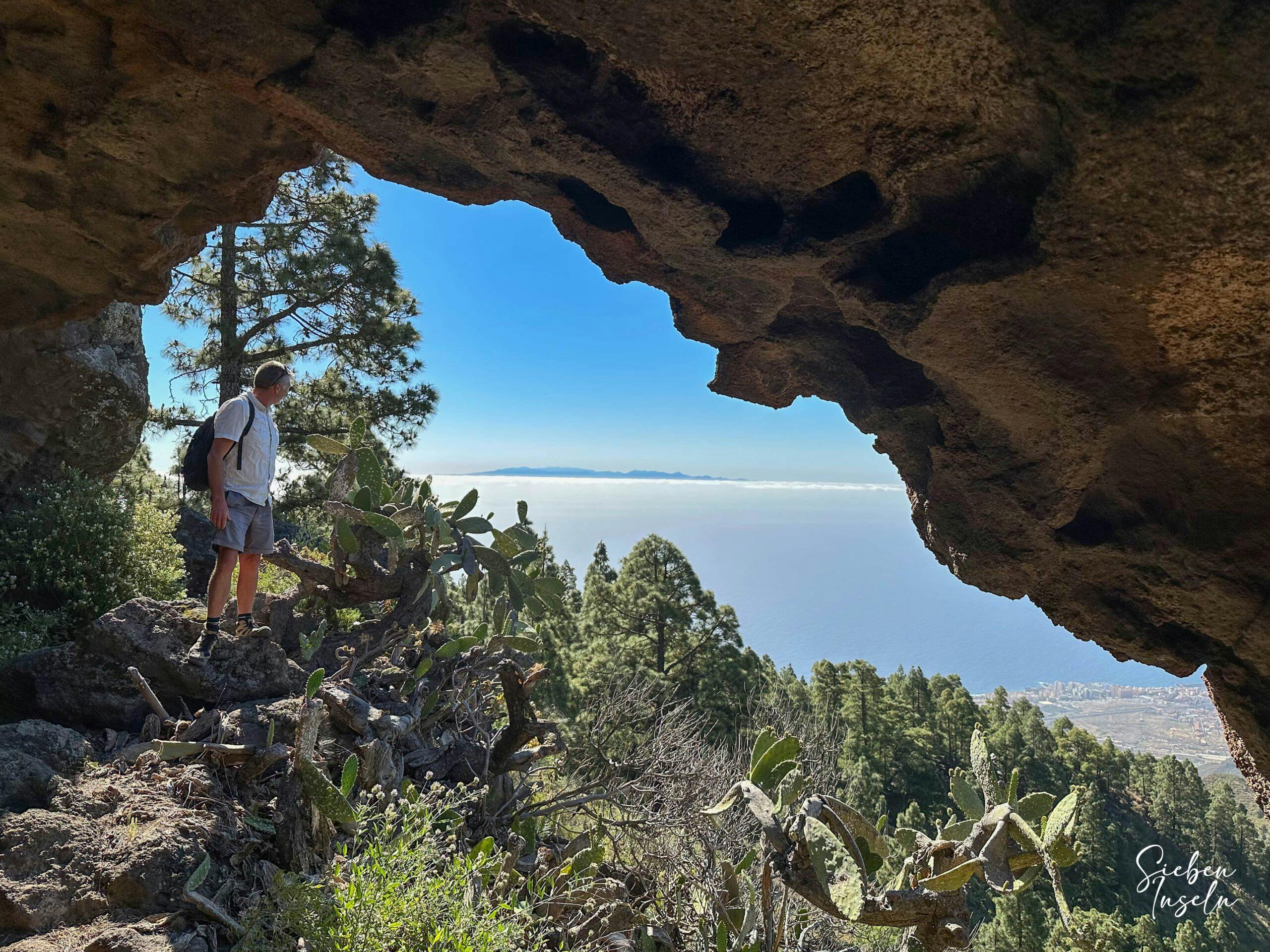
This hike on the eastern slopes of Tenerife starts at an altitude of 580 metres. You hike steeply up a forested ridge through the protected landscape area of Las Lagunetas. The ridge takes you up to the Cumbre Dorsal of Tenerife at approx. 1,460 metres altitude. On the way, you will also pass the Cueva de Unchico cave (cover picture).
View from the ascent path down into the valley above Igueste de Candelaria and to the Barranco de Araca
And not only from there can you enjoy magnificent views of the entire east coast of Tenerife and the neighbouring island of Gran Canaria. At the top, you have a quiet traverse in the forest and perhaps a rest in a nice spot with a view. Then you go downhill again on the other side of the slope towards Igueste de Candelaria.
Igueste de Candelaria Hike Track
General information about the Igueste de Candelaria hike
Starting point and approach
The starting point of the walk is in the upper part of the small town of Igueste de Candelaria on Calle de los Márgenes (28.389834, -16.388034).
Calle de los Márgenes in Igueste de Candelaria - starting point of the hike
Arrival by car
You come to Candelaria from the north or south via the TF-1. Here you take the northern exit and drive on the TF-28 in the direction of Barranco Hondo. But when the TF-28 forks, leave it and continue straight uphill towards Igueste de Candelaria. There you continue on the main road through the entire town. Continue uphill on Calle la Morrita into the valley ahead. Finally, you will come to Calle de los Márgenes. Here you can park at the side of the road at a place where you can find space on the narrow road and start the hike. Of course, you can also park further down in the village and walk up to here.
Arrival by bus
Titsa bus lines only go to Candelaria. I did not find a bus line to Igueste de Candelaria on the Titsa homepage. The closest bus lines to Igueste de Candelaria are 10, 111 and 122. You may be able to take a taxi from Candelaria to the point of departure. For more information on all bus routes in Tenerife, visit the Titsa homepage.
Time
Article summary and large selection of GPS hiking tracks
Sign up for my newsletter now and get exclusive access to my collected GPS tracks as well as all the brief information about my articles.
I don’t like to give general times for hiking tours, because the times are very individual. We needed just under 5 hours for this round tour with a few stops.
Altitude profile of the Igueste de Candelaria hike
Altitude difference and route length
The difference in altitude is about 880 metres and the route is a little less than 12 kilometres long.
Requirements
For the most part, you walk on good hiking trails. At the end, however, the trail goes downhill on very steep and stone-strewn small paths. Even uphill, the entrance path is a little narrow and not easy to find. Surefootedness is therefore required for the descent and a good level of fitness for the ascent.
Refreshment
Refreshments are only available at the starting point in Igueste de Candelaria. Therefore, please take enough water and, if necessary, food with you for the hike.
Track of the hike Igueste de Candelaria (centre yellow) and left of it track Igonse (yellow) right in red round trip Barranco Hondo and top left round trip high above Candelaria (blue, green)
Variants
If you wish, you can extend the hike by starting in the centre of Igueste de Candelaria. Also up near the Esperanza forest you will find many hiking signs that you can follow in all directions (e.g. Barranco Hondo).
hiking signs towards La Lagunetas
ou can find more hikes in the vicinity on SiebenInseln:
Soon I will also present a great circular hike from Barranco Hondo on SiebenInseln.
Descent with a view of Gran Canaria
Hike Igueste de Candelaria
Igueste de Candelaria section to ridge before Montaña Arguama
You start your hike in the high part of Igueste de Candelaria on the Camino de los Márgenes at about 580 metres altitude. Depending on where you parked, you hike further up the Camino. At a yellow fenced-in house, a kind of track branches off to the right from the main path. Follow this for a short while in the direction of Barranco del Madroño. Just before the wide path ends straight ahead, an inconspicuous path branches off to the right uphill on a stony slope.
Article summary and large selection of GPS hiking tracks
Sign up for my newsletter now and get exclusive access to my collected GPS tracks as well as all the brief information about my articles.
Hikers on the path at the junction of the Camino del Márgenes with the ascent path.
Follow this path. It takes you steeply uphill. As confusing as it is at the beginning, it becomes clearer later on. You hike up the slope of Montaña Arguama (740 metres altitude). Eventually you reach a small ridge. If you want a small extension, the path to the right will take you to the summit of Montaña Arguama. Otherwise, or afterwards, continue climbing along the ridge with the path to the left.
Hikers on the path at the junction of the Camino del Márgenes with the ascent path.
Route section ridge before Montaña Arguama to Camino Lomo de Barca
Now the steep ascent continues. You can enjoy magnificent views of the east coast of Tenerife, the Atlantic Ocean, the valley below you above Igueste de Candelaria and the neighbouring island of Gran Canaria. The ascent on the path remains steep. Every now and then the path is a little hard to find. Then it leads over rocks. But since the ridge is not so wide, you will always find the way quickly. After a while you will pass an impressive cave (Cueva de Unchico).
Hikers on the ridge trail
There you can take a short break with a good view. Then the steep ascent continues and you finally reach a wide road. This is the Camino Lomo de la Barca, which also leads up here from the other side of the ridge from Igueste de Candelaria. On this path with electricity pylons you now hike steeply upwards. From time to time you can choose whether to follow the steep wide ridge path or the serpentine path in the forest. Due to the steep ascent, you have already reached an altitude of 1300 metres.
View from the higher ridge path to the east coast of Tenerife and the Atlantic Ocean
Route section Camino Lomo de Barca to junction of narrow path in forest
Finally, turn off the main path with the BC 2 towards Las Lagunetas. The wide forest path now leads you in large arcs only slightly uphill through the pine forest. If you like, you can continue straight on to the TF-24 and La Lagunetas. We preferred to turn left from the main path towards Montaña del Dornajo into a small ravine. This leads you uphill a little through the forest. Then, shortly before reaching the TF-24, you will again reach the Camino Lomo de la Barca, which you will cross at an altitude of 1460 metres.
Hiking path steeply uphill parallel to electric lines
At this point there are two paths. Follow the left path downhill into the forest. This forest path first takes you on wide, comfortable serpentines down towards the Barranco de Leres. Above it, you now walk along the left side of the slope. After a while, the path leads over a kind of bridge to the right. Shortly afterwards, a narrow path branches off to the left from the wide forest path. Follow this small path.
Hiking trail on the heights through the forest
Route section branch off narrow path in the forest to starting point Igueste de Candelaria
The descent continues along this narrow path through the pine forest above the Barranco de Leres. After that the descent continues gently up and down for some time, as you have to cross a few small ravines. The path remains steep and is sometimes quite uncomfortable, as it is covered with many stones. In between, however, you can continue to enjoy beautiful views of the east coast of Tenerife ahead of you.
Descent path towards Igueste de Candelaria above the Barranco de Leres
Finally, you pass the first farmsteads and terraced fields of Igueste de Candelaria. However, the steep descent continues. Then you reach a road. This is the Camino de los Márgenes again. Follow this for a long time straight downhill towards the centre of Igueste de Candelaria. Depending on where you parked, you will also return to your starting point this way.
View from the descent path over the valley with terraced fields and the mountain range to Igonse
And finally
I hope you enjoyed this circular walk through Igueste de Candelaria. If you are in good shape, you will definitely enjoy this hike with its great views. I hope you enjoy all your hikes,
Dagmar from Siebeninseln
Thank you for reading!
If you've found my hiking guides on SiebenInseln helpful for your Canary Islands adventures, please consider leaving a small tip. Your support is greatly appreciated and helps cover the costs of maintaining this blog.