Igueste de San Andrés – a small hamlet on the edge of the Anaga Mountains
Originally, the small village of Igueste belonged to the neighbouring village of San Andrés. Today, the little village of Igueste de San Andrés with its 500 inhabitants is administratively assigned to the district of Anaga. It is located with its colourful little houses at the lower end of the Igueste valley of the same name. A wide variety of fruit trees can grow in this valley because of the good climatic conditions. Archaeological finds prove that the Igueste Valley has been inhabited since the Guanche period.
Map
View from the ascent path to Igueste de San Andrés and Santa Cruz de Tenerife
The „Semáforo de Igueste“ traffic light station, which was established in 1872, is also interesting. From that year on, the station maintained visual communication with the naval command in Santa Cruz through a flag system. Until 1970, when the station was abandoned, the lighthouse keepers lived there with their families. Today, there is only an empty building out on the cliffs, which you can visit on the hike.
Signposting in Igueste TF 5.1 direction Wl Semáforo - follow this road for a while.
Hikes from Igueste de San Andrés
There are two official hiking trails in Igueste de San Andrés. PR-TF 5.1 goes from the village up to the flag station El Semáforo. You start your hike on this trail. The other trail, PR-TF 5, goes from Igueste de San Andrés up to Chamorga. On this trail you will return on a section from Lomo de las Casillas. In between, you will find small paths and trails that are not always easy to find.
the old house with ruined walls opposite the Mirador La Atalaya
The hike along the ridge path offers wonderful views. However, a head for heights and surefootedness are a prerequisite, as is a little scrambling. Other highlights of this wonderful hike are the visit to the Mirador La Atalaya and the Lomo de las Casillas with its abandoned houses.
Igueste - Las Casillas Circuit Track
General information about the ridge walk above Igueste de San Andrés
Starting point and approach
The starting point of the hike is the small village of Igueste de San Andrés on the TF-121.
Arrival by car
You can only get to Igueste de San Andrés via Santa Cruz de Tenerife and San Andrés on the TF-121. The road ends here in the upper valley. You can park anywhere on the side of the road in Igueste. A good starting point for the hike is the Carretera de Igueste de San Andrés. From there you start the hike and return to it.
Arrival by bus
The Titsa bus line 945 goes to Igueste de San Andrés. The bus stop is right at the starting point of the hike. More information is available on the Titsa homepage.
Time
I don’t like to give general times for hiking tours, as the times are very individual. We needed 5.5 hours for the whole route with a few breaks and the detour to the Mirador La Atalaya.
Article summary and large selection of GPS hiking tracks
Sign up for my newsletter now and get exclusive access to my collected GPS tracks as well as all the brief information about my articles.
Altitude profile of the Igueste - Las Casillas hike
Altitude difference and route length
The cumulative difference in altitude is about 1000 metres and the route is just under 12 kilometres long.
Requirements
You walk a large part of the route on good hiking trails. However, almost half of the trail is on small, impassable paths. There the paths are not always easy to find. A head for heights and absolute surefootedness are a prerequisite. Finally, there are some sections that you have to overcome with a bit of scrambling. The length and the altitude metres to be overcome also require a good level of fitness.
Refreshment stops
I did not even see any refreshment stops in Igueste de San Andrés. Therefore, please take enough water and, if necessary, food with you for the hike.
Of course, you can also follow the PR-TF 5 trail, which takes you to Lomo de las Casillas, further up the Anaga. If you like, you can even hike to Chamorga. From there you might return by bus. If you want to shorten the tour, skip the extensions to Lomo de las Casillas or Mirador Atalaya.
Hike Igueste de San Andrés
Igueste de San Andrés section to Semáforo de Igueste path junction
You start your hike in Igueste de San Andrés on the main road Carretera Igueste de San Andrés. You walk towards the sea along the Barranco de Igueste and then turn into Calle San Pedro. The yellow and white hiking trail is signposted PR-TF 5.1 towards Semáforo. You walk past the Iglesia de San Pedro Apóstol. You climb a few steps and then take a kind of coastal path (Pista el Cementerio). This first takes you slightly uphill. Then a steep path turns off to the left of the path, signposted PR-TF 5.1.
View of Igueste from the lower hiking trail
Follow this washed-out and partly paved path uphill for a long time. It takes you very steeply up the ridge with very beautiful views of Igueste de San Andrés and Santa Cruz de Tenerife. A climb up the steep face that is quite something. At the top, you can make a detour to El Semáforo de Igueste (600 metres down). If you decide to make this extension, you will have to return the same way afterwards, because there is no way to continue from the Semáforo.
Hiking trail to the house opposite the Mirador La Atalaya
Route section branch Semáforo de Igueste path to ravine below the ridge
Up here on the ridge, leave the signposted hiking trail to the left on a small path. Take a small path along the slope and climb up to the ridge. From here, the trail continues straight up the mountain. After a short while you will reach a house and ruins. From here you can take a short detour to the right to Mirador Atalaya. This detour is worth it just for the magnificent view of Playa Antequera.
Article summary and large selection of GPS hiking tracks
Sign up for my newsletter now and get exclusive access to my collected GPS tracks as well as all the brief information about my articles.
Back at the house, follow a path marked with two large stones. This takes you downhill on the right side of the slope on a narrow path. After a while, a path branches off to the right to Playa Antequera. However, you continue straight ahead. From time to time, the path is a little difficult to find. But it always runs just along the ridge or on the right side of the slope. Finally, it takes you down into a small ravine, where you continue to hike up.
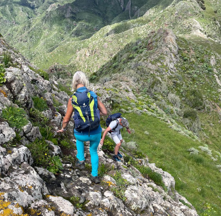
Hikers on the descent path on the slope behind Mirador La Atalaya
Route section Gorge below the ridge to hiking trail PR-TF 5
After a while, the path leads back to the ridge. You follow the path along the ridge and continue hiking steeply up. Every now and then, the path lowers briefly, only to rise again. Shortly before a prominent peak, the path turns sharply left onto the ridge. From now on, you hike or scramble downhill on ridge paths. This is probably the most difficult part of the entire hike. The direction is clear. It’s downhill along the ridge. But the path is not always easy to find.
Hikers on the descent path on the slope behind Mirador La Atalaya
But eventually there is a way to get on at all points. Finally, the ridge path widens and you only have to overcome another small hill in front of you. Then you come to a place where the path from Playa Antequera comes up on the right. From there, continue straight up along the ridge. You will then reach the PR-TF 5 trail, which comes up from Igueste de San Andrés on the left. If you don’t want to go any further, you can also go downhill to the left.
Descent path towards Lomo de las Casillas
Route section PR-TF 5 to Lomo de las Casillas
Otherwise, simply continue along the PR-TF 5 trail towards Chamorga. It will take you uphill a little at first, then it will lead you up the slope and finally reach the ridge. On the other side of the ridge, it quickly takes you along the slope and around a large rocky outcrop. Finally, it descends through a lot of bushes to the Lomo de las Casillas.
Here on the ridge you will find a whole village with many interesting ruins and cave houses. The ideal place for a rest. If you like, you can then continue on PR-TF 5 towards Chamorga. But for the round trip, you have to take the same path back to the junction where you met PR-TF 5 after the ridge walk.
Hiker on the ridge trail
Route section PR-TF 5 to Igueste de San Andrés
Back at the junction, simply follow the PR-TF 5 trail downhill towards Igueste de San Andrés. It is well paved in many places and quickly takes you downhill over a ridge on many serpentines. The trail joins the TF-121, which ends up here in the Barranco del Igueste. From here you simply follow the TF-121 down the valley.
Descent path down towards Igueste
You pass through the small hamlet of Lomo Bermejo. In very wet times, the road is flooded with water from the barranco in some places, and you have to wade through it. Finally, you will reach the main road again in Igueste de San Andrés. All you have to do is walk back to your parking space or to the bus stop.
Path on the road shortly before Igueste de San Andrés - now and then a little covered with water
And finally
I hope you enjoyed this hike along the steep ridge trail with its magnificent views. If you did, I’m sure you’ll enjoy my next hike to Playa Antequera, which also starts from Igueste de San Andrés. I hope you enjoy your hike,
Dagmar from Siebeninseln
Thank you for reading!
If you've found my hiking guides on SiebenInseln helpful for your Canary Islands adventures, please consider leaving a small tip. Your support is greatly appreciated and helps cover the costs of maintaining this blog.
Thank you for your support!
SSL secured
Comments
Edmunds - 10/10/23, 07:00 PM
I just did a combo variant of this and the Playa de Antequera walk. (10.10.23)
First I walked up to Semaforo, then the Mirador and then down to Playa de Antequera as in that walk. Afterwards, instead of turning towards north and then hiking back down the road, I did the ridge walk.
However, instead of walking the whole ridge back to Mirador/Semaforo (I didn’t want to go all the way since I had already been there), just before the track that goes down to Antequera, there is a third (middle) track that goes down to the road to Igueste. On the Komoot app it says „dangerous trail“ and it probably is in bad weather, but since I was battling super high desert heat (+38C) on this trail, I did not encounter any problems and didn’t find the trail down any more dangerous than the ridge walk.
The trail finishes at the road and I walked to my car afterwards.