Circular hike via Las Vegas with cave houses, giant pines and tajeas
Today’s circular hike over the small village of Las Vegas takes you 10 kilometres into the eastern slopes of Tenerife. You will see cave houses and the famous old pine Pino del Guirre. The tour will take you 600 meters up into the mountains and over the Risco del Muerto back down to Las Vegas.
Map
For all those who want „less“, there is the possibility of a shortened 7 km long hike. The rural hiking trail gives interesting insights into the Canarian architecture of the cave houses and runs past numerous water pipes that transport the water from the mountains to the south of the island.

hiking path Las Vegas
Las Vegas in Tenerife
The small district Las Vegas has little in common with the world-famous Las Vegas in the United States. In Las Vegas on Tenerife it is a little quieter. You will definitely not find a casino there. Las Vegas belongs to the municipality Granadilla de Abona and lies on approx. 650 height meters between El Rio and Arico. The population is currently only 180 inhabitants, as it has been constantly declining in recent years. If you decide to visit this small town during this hike, you will discover many empty houses and ruins.
Ascent serpentine path near Las Vegas
Even a restaurant in Las Vegas will be in vain. But the idyllic mountain village is beautifully situated in the middle of a wild green landscape. It offers stunning views of the southeast coast of Tenerife and a natural environment of pine forests. In addition, there are many endemic plant species, such as the balm spurge or the viper’s head. A favourite place for hikers and climbers who try their hand at the Risco del Muerto.

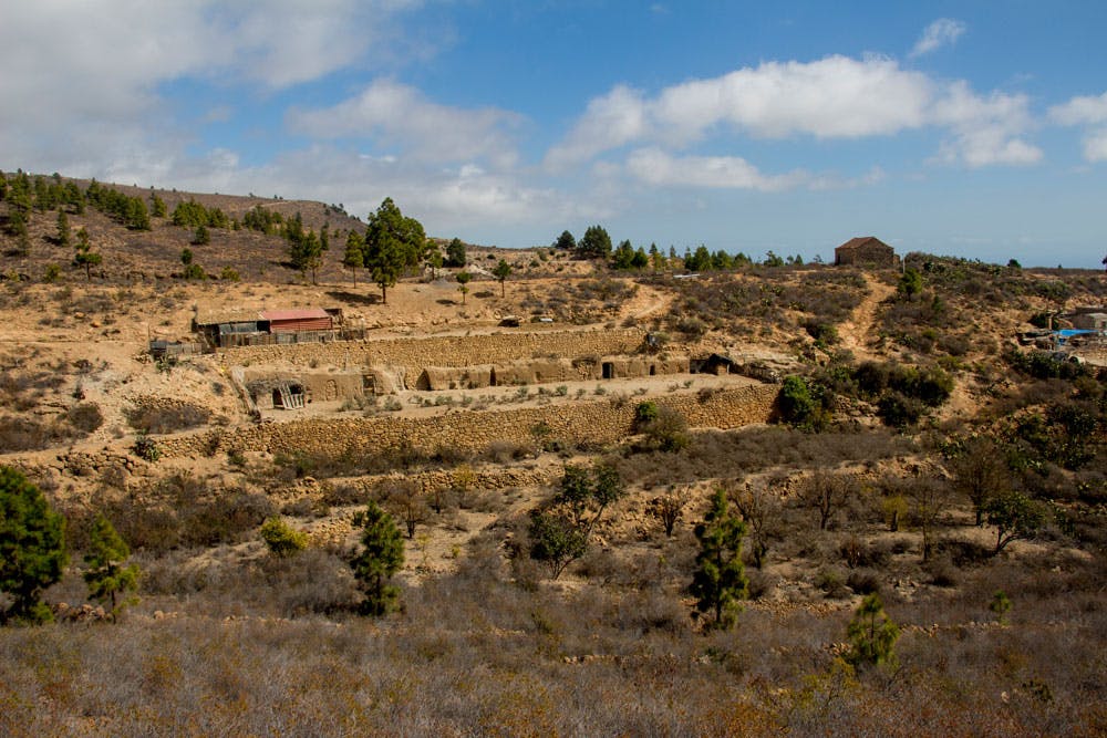
Finca with caves at the hiking path - Las Vegas
What does Las Vegas actually mean?
Las Vegas gets its name from la vega. But what is a Vega? By Vega is meant a kind of floodplain, a low level fertile area. This is regularly flooded by precipitation. Such areas were, of course, very much appreciated by settlers. So in the vegas wine, vegetables, fruit and potatoes were cultivated. This was also the case in Las Vegas. Today, however, the fields are abandoned and covered in green wilderness.
But at that time this patch of land in the barren, dry south of the island was almost an oasis. The nearby water sources and the fertility of the soil made the area around today’s Las Vegas one of the most popular colonial settlements of the Castilians.

Old stone houses at the path - las Vegas
Cave dwellings and tajeas near Las Vegas
Around Las Vegas and of course on the circular hike you will always come across cave dwellings and houses. The geological conditions here in the southeast of Tenerife facilitate the construction of such cave dwellings. Therefore they are also part of the traditional living culture in southern Tenerife. There are even farms in this area that have housed their animals in the large caves. In the hot summer the cave dwellings are also pleasantly cool for the animals and in the winter they warm.
Furthermore, you will often come across the water channels of the tajeas on this tour. They were created to transport the water from the north to the barren south. A canal is the canal of the south that transports the cool water from the mountains of Fasnias over 73 kilometres to the south of Tenerife. Another channel is called Artajea del Consuelo (Channel of Consolation) because it transports large quantities of water from the mountains to the dry south coast.
But now the general information and then the hiking can start.

track hiking circular Las Vegas
General information about the circular hike Las Vegas
Starting point and approach
Street above the small village Las Vegas at the Calle de las Vegas – hiking sign.

starting point of the hike
Arrival by car
Article summary and large selection of GPS hiking tracks
Sign up for my newsletter now and get exclusive access to my collected GPS tracks as well as all the brief information about my articles.
Sign up nowComing from north and south on the TF-1 motorway, take exit 49 towards Chimiche/El Río and go uphill. You are essentially going straight uphill. At the junction with the TF-28, continue straight ahead onto Calle de Las Vegas. Before you reach the place below on your left, you are already at the starting point of the hike along the road. A hiking sign points to the circular path. At the roadside there is room for cars. Since no bus stops here and bus journeys are connected with a footpath of another hour, the journey by car is recommended.
Arrival by bus
A bus does not go to Las Vegas. The next bus goes to Pedrera, which is at the intersection with the TF-28. From there to Las Vegas it is about an hour on foot. The Titsa lines 34/36/408/430/111/711 go there. For more information see homepage Titsa. Time
I don’t like to give general time information for hiking tours, because the times are very individual. For this tour I needed a good 3.5 hours with comfortable hiking and some breaks.
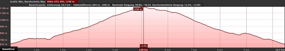
elevation profile Las Vegas hike
Difference in altitude and distance
The difference in altitude is approx. 600 metres in the descent and ascent. The route is 10.5 kilometres long. The short distance is about 500 meters in altitude and about 7 kilometers long (track: orange marking).
Requirement
An easy and for everyone with a bit of stamina easy to master tour. The paths are wide and well signposted. And if you want less, choose the shorter lap.
Refreshment
There are no restaurants, bars and shops in Las Vegas. Therefore take enough water and food with you.
Note for dog owners
The hiking trail runs over some open water channels, so that water is provided for the four-legged friend.
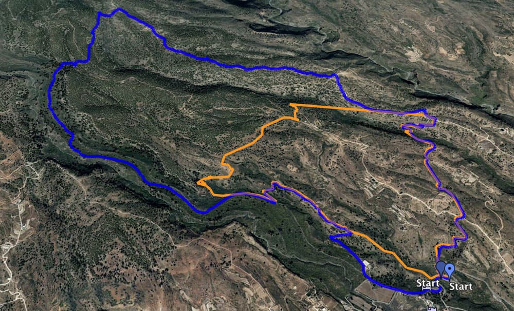
Track Las Vegas: blue big circle - orange small circle
Variants
This tour can be easily combined with various other hikes and circular walks in the vicinity. There are signposts all along the circular route, so you can extend or shorten the tour as you wish (see also illustration). Furthermore, this hike can be combined well with the adjacent circular hike La Higuera. 
postsign
Tenerife circular hike over Las Vegas
Section Las Vegas to the road after 2.5 kilometers
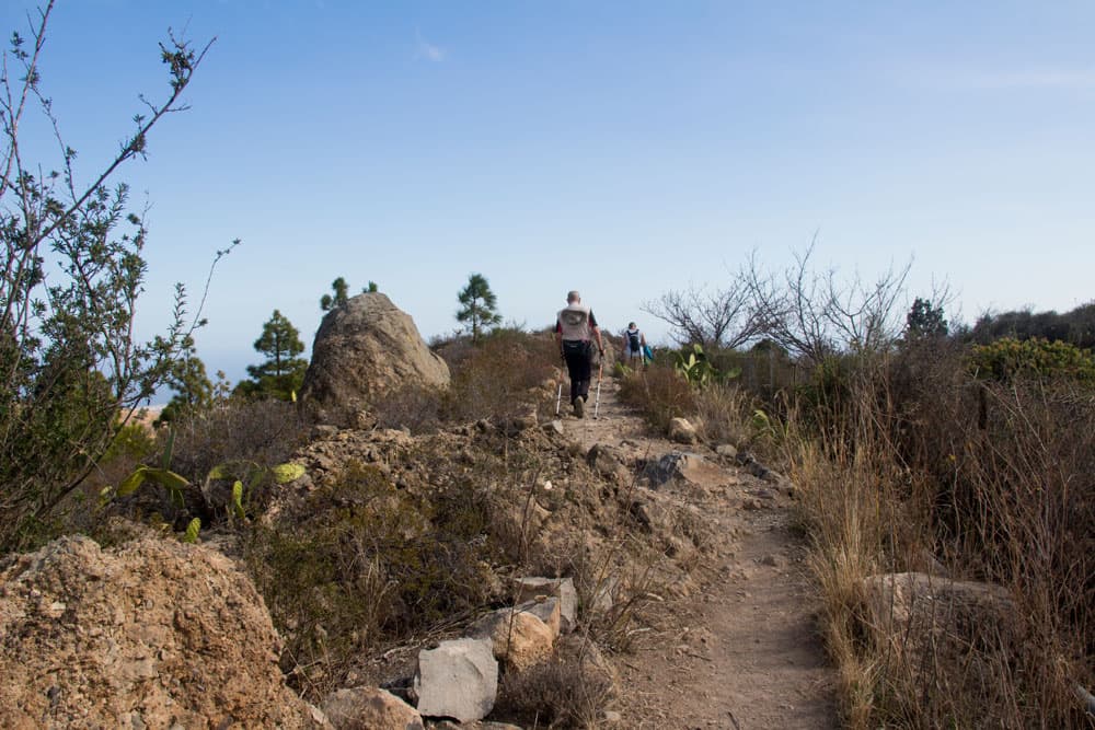
You start directly at the street Calle de Las Vegas above the small district Las Vegas. On the right there is a sign for the hiking trail PR – TF 83.3. First you go uphill towards Risco del Muerto and Pino del Guirre. The path is wide, not to be missed and initially leads you uphill over light sandstone and rock. You walk through the formerly fertile landscape around Las Vegas described above.

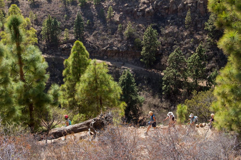
hikers on the way up - Las Vegas
Along stone walls and from time to time through areas covered with pine trees, the route climbs. After 2.5 kilometres you have already covered a few metres in altitude and reach a wide driveway. Already far below you are the houses of Las Vegas. You cross the road. The trail continues on the opposite side.
Section of the road to the hiking junction
After a short time you will see the first big „cave mansion“ in front of you. At some distance you pass a farm on the left which is partly built into the slopes. The trail leads you slowly along a small Barranco edge. You walk on a path, left of you the rocky side of the mountain and gradually surround the small Barranco.

Panorama - view from the hight to the southeast coast of Tenerife
Article summary and large selection of GPS hiking tracks
Sign up for my newsletter now and get exclusive access to my collected GPS tracks as well as all the brief information about my articles.
Sign up nowOn the other side of the Barranco you go up the mountain in steep long hairpin bends. This is the steepest part of the whole hike. At the top you can enjoy a wonderful panoramic view over the eastern slopes of Tenerife. You follow the hiking trail to the left. After some time (3.2 kilometers from Las Vegas) you come to a hiking crossroads.

crossroad hikers - small and big circle Las Vegas
Section of the hiking trail to the Pino del Guirre
At this intersection, Las Vegas is signposted to the left with the PR-TF 83.4 (4.4 kilometers). If you want to do the small hike, turn off here and follow the signs back to Las Vegas. The big round continues straight ahead. It goes on a broad way further uphill. On the way you cross a water channel.
Las Vegas- Pino del Guirre
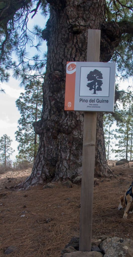
One kilometre after the crossroads you are standing under an impressive huge pine tree. This is the famous Pino del Guirre. In case the sun should burn. Here you will surely find shade. Nearby is also a waterhole the Fuente de El Guirre (sign 60 meters) to find. You follow the hiking trail PR-TF 83.3 now with the sign El Aserradero.
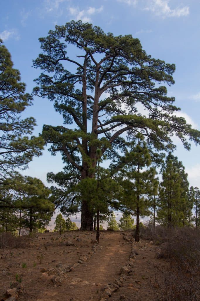
Pino del Guirre - tall pine tree
Section Pino del Guirre to the Risco del Muerto
You continue uphill through the pine forest on the stone-enclosed hiking trail. After some time you will reach a fork in front of an old stone wall. Here you go around to the left. Now follow the signs PR-TF 83.3 direction Risco El Muerto. Finally the trail continues straight ahead uphill. Turn left and follow the PR-TF 83.3 signs towards Risco El Muerto.

Risco del muerto - rock on the Las Vegas circular
Now you’ve climbed your meters. From here it’s mainly downhill. On a path along the slope it goes first leisurely and then also sometimes steeper downhill. The path crosses another road and continues on the next side. You circle around a small Barranco. Finally you can see a light rock wall on the left side. This is the Risco del Muerto. Here you can often see climbers who want to take on the „Death Rock“. A small path PR-TF 83.1 leads to the foot of the rock.

Demolition edge with pine forest
Section Risco El Muerto to Barranco off Las Vegas
You continue to follow the white and yellow marked hiking trail, which is often bordered with stones. You can still look at the fascinating rock face for some time. After some time you will reach a crossroads again. On the right you go uphill with the PR-TF 83.1 to Escurriales. You keep straight ahead. After Las Vegas back there are now still 4 kilometers. Through bushes and the view of the impressive rock walls it goes further downhill.

Hike Las Vegas - descent
hiking path along the chanel
In front of you you can enjoy the view of the Atlantic Ocean and the southeast coast of Tenerife again. After about 2 kilometres you come to another big pine near a crossroads. Your hiking trail towards Las Vegas leads you down to the left into a Barranco. At the end of the Barranco you border it and climb up again on the other side via water pipes.

postsign circular Las Vegas
Section Barranco to Las Vegas
On the other side above, you can once again enjoy a good view of the entire surroundings up to the coast. The trail will take you past some cave houses shortly afterwards.

inside of an old house
These even seem to be still inhabited at the moment. If possible you should risk a small view inside. Afterwards the path leads you over the height and past several water pipes and canals.
You can enjoy the wild environment of the once so fertile environment. On gravel paths and paths you continue downhill. You’ll also come to a junction that marks the 7-kilometer Circular around Las Vegas (PR-TF 83.1 and 83.4). At the end a small path leads you along the slope down to the road. From there it is only a few meters to the starting point.

hiking path Las Vegas
And finally
I hope that you enjoyed this circular walk on the east side of Tenerife and wish you interesting explorations and beautiful hiking experiences,
Dagmar von SiebenInseln