La Higuera – big round walk beside the classic Las Vegas round
The small hamlet of Las Vegas on the east side of the island of Tenerife is known by outdoor enthusiasts for its good hiking and climbing possibilities. The classic round tour, which starts in Las Vegas, I already described in the small and the big variants here on Sevenislands. Map

the hamlet of La Higuera
Less known is another big round tour, which borders on the classic round in the west and leads over the small village La Higuera. Therefore I have called this round tour La Higuera Tour.

Sandstone walls
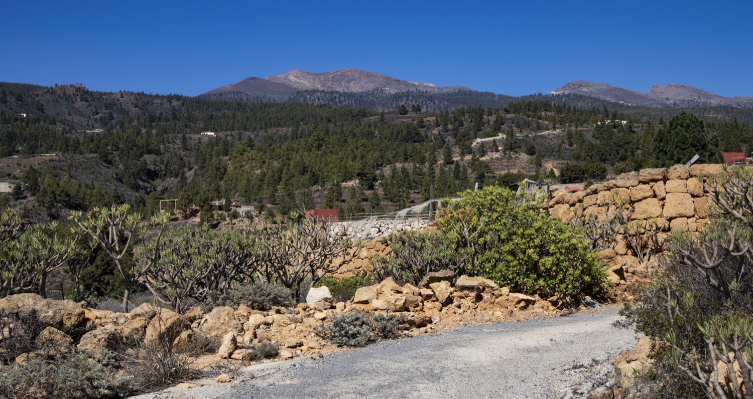
La Higuera consists of only a few small houses and farms and is situated high up on the eastern slopes of the Teide above Las Vegas. There are two three big canyons nearby, the Barranco de Las Vegas, the Barranco de las Fuentes and the Barranco de Mocán. You will hike through the Barranco de Las Vegas on this tour. But first, this tour starts at the same location as the classic Las Vegas tour. However, it will take you further up the mountain slopes and then back west via La Higuera.
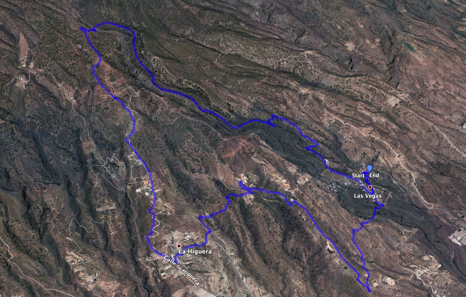
Track circular hike La Higuera
General information about the circular walk La Higuera
Starting point and approach
Starting point of the hike is the street near the small village Las Vegas at the Calle de las Vegas – there is a hiking sign.
GPS data: 28.146120,-16.546771
Arrival by car
Coming from the north or south on the TF-1 motorway, take exit 49 towards Chimiche/El Río and drive uphill. Keep going straight uphill for the most part. At the intersection with the TF-28, continue straight ahead onto Calle de Las Vegas. Even before you reach the place above you on the left, you are already at the starting point of the walk along the road. A hiking sign indicates the circular route (Las Vegas circular route). At the roadside there is enough space for cars. As there is no bus stop here and bus journeys are connected with a walk of another hour, it is advisable to arrive by car.
Arrival by bus
A bus does not go to Las Vegas. The nearest bus stop is in Pedrera, which is at the intersection with the TF-28. From there to Las Vegas it is about an hour walk. Titsa lines 34/36/408/430/111/711 go there. For more information, please visit the Titsa Homepage. Time
I don’t like to give general time indications for hiking tours, because the times are very individual. We needed 5.5 hours for this hike with extensive rest and many small photo breaks.
Article summary and large selection of GPS hiking tracks
Sign up for my newsletter now and get exclusive access to my collected GPS tracks as well as all the brief information about my articles.
Sign up now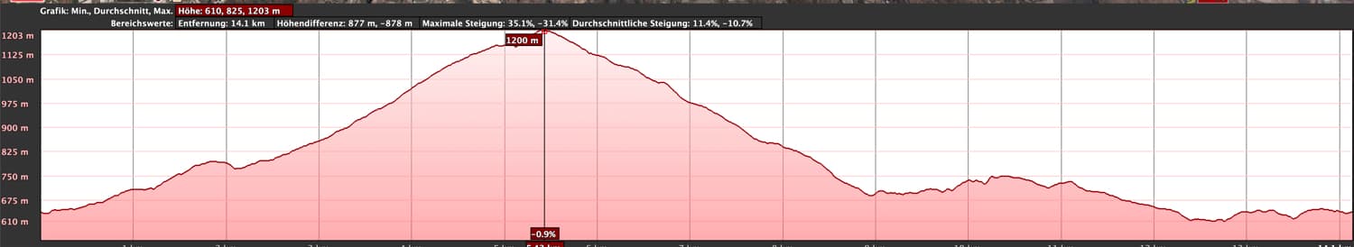
elevation profile La Higuera Hike
Height difference and distance
The difference in altitude is about 780 metres. So the hike is almost 15 kilometres long. The classic Las Vegas hikes are only 10.5 and 7 kilometres long. Requirement
The La Higuera hike is basically a hike for everyone. However, a little bit of stamina and the joy of a longer hike should be already present.
Refreshment
There are no restaurants, bars or shops along the route. Therefore you should bring enough water and if necessary food.
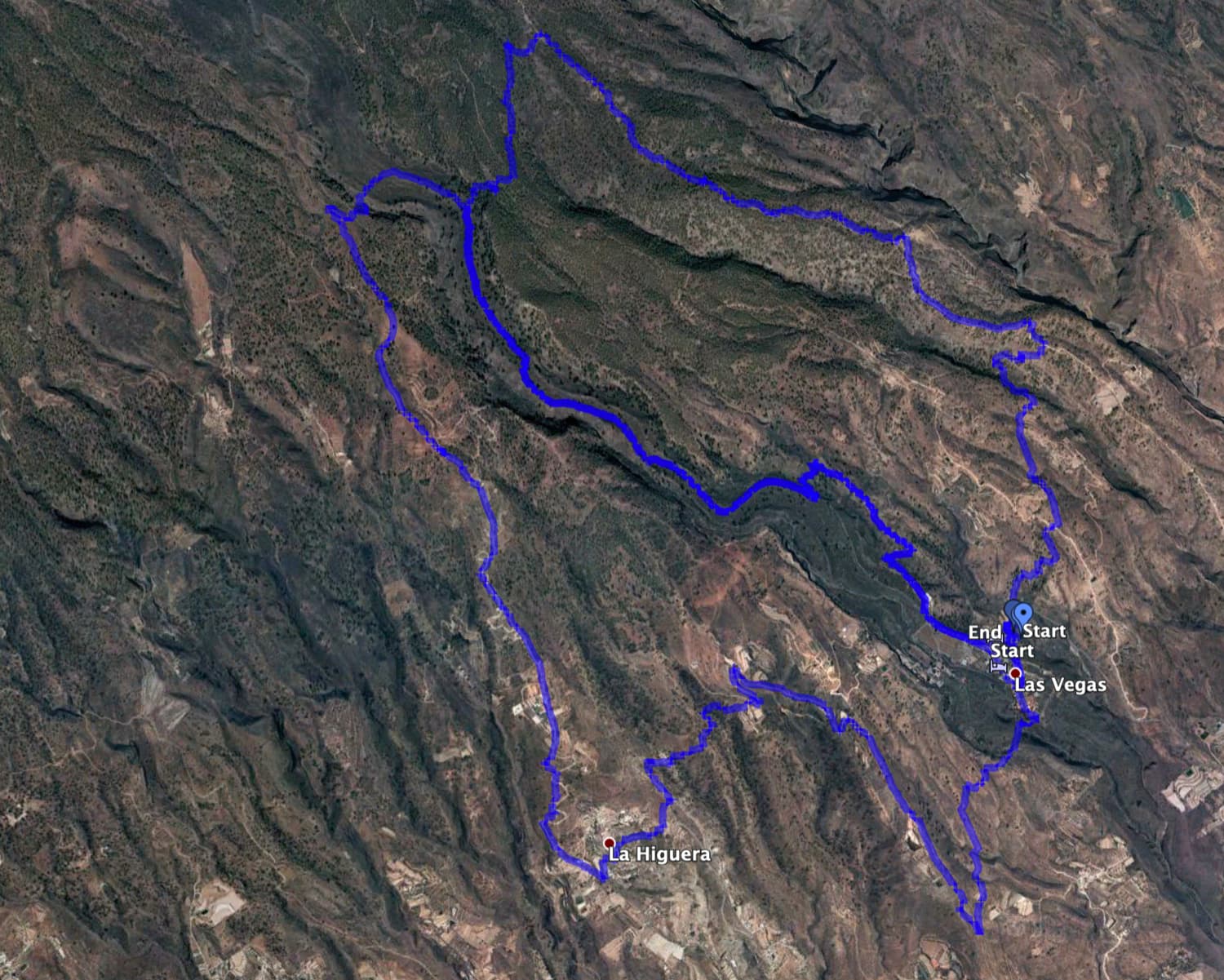
Tracks of the hike Las Vegas (right) and La Higuera (left)
Variants
This tour over La Higuera can be combined with various other hiking and circular walks in the vicinity. It can be combined especially well with the classic Las Vegas hike in any direction. So you can do a small to a very large round trip around Las Vegas and Higuera, depending on your needs. For long distance hikers: From this tour you can also climb even higher and reach the Paisaje Lunar or even the Guajara. 
Gorges, pine forests and water channels dominate the landscape
La Higuera circular hike
Route section Las Vegas to rock face at Risco del Muerto
You start your hike directly at the street Calle de Las Vegas under the small district Las Vegas. On the right you will see a signpost indicating the hiking trail PR – TF 83.3 There the classic Las Vegas Tour starts right uphill. For the La Higuera hike, however, you first follow the road further into the village of Las Vegas. In the village the road meets a crossroads called Calle de Nuestra Señora de la Esperanza on the left. Here you will come back later. Now keep to the right on Calle Guajara. Follow this street for a while, straight through the village, out of the village and along fields and meadows.

Barranco crossing
After a short time the road turns into a path. This leads you past two detached buildings straight uphill. You continue walking uphill and quickly leave Las Vegas underneath you. Looking back you already have beautiful views of the east coast of Tenerife. Occasionally you will pass through sparse and later on more pine forest. You walk uphill parallel to the Barranco de Las Vegas, which is on your left side. On your right side you will pass a very steep rock face after some time. This is also where the notorious Risco del Muerto (Rock of Death) is located. And from time to time you can discover climbers on the rocks in the area.

Old threshing floor by the wayside
Article summary and large selection of GPS hiking tracks
Sign up for my newsletter now and get exclusive access to my collected GPS tracks as well as all the brief information about my articles.
Sign up nowRoute section rock face at Risco del Muerto to the other side Barranco de Las Vegas
You come to a fork. To the right you get to the classic Las Vegas round. However, I have described it the other way round in the article, so that at this point you get to the current way there and the way back described there. Therefore the part of this walk La Higuera from Las Vegas to this point is identical with a part of the return path of the Las Vegas walk. But from this point on, keep left at the fork and continue to climb uphill parallel to the Barranco de Las Vegas. This will take you off the Las Vegas circular walk. 
Hiking trail through a goat farm
After a short while the path turns left and takes you first to the edge of the gorge and then down into the Barranco de Las Vegas on serpentines. You will cross the Barranco valley with a small arch. In the middle of the Barranco ground you will find many paths and further up on the Barranco rim a large old threshing floor, which could certainly tell stories of the former settlers of the gorge. On the other side of the Barranco you will climb up again. Now you have also reached the highest point of the hike at 1200 metres.

Ascent in the Barranco
Route section other side Barranco de Las Vegas to La Higuera
Once you have reached the top of the other side of the Barranco, the way back will now be largely downhill. Walk around the old threshing floor mentioned above and then keep left downhill. After a while you will come to a driveway. Follow this to the left and walk through the middle of a goat farm with goat pens. If you are lucky, you will even come across many goats that will look at you curiously. Then you continue down a ridge through partly wooded terrain.

single fincas, cave houses and terraced landscapes
After a short while you will come across the road again, which you now follow to the left. The path is steep in places and there are already a few farms with terraced fields to the left and right. The first houses of La Higuera. Before you reach the actual village of La Higuera, you will walk downhill for quite a while. Sometimes the path shortens the driveway a little. But then you walk into the village on Calle La Higuera and you can visit the small hamlet.

View over the slopes up to the Cañadas
Route section La Higuera to starting point at Las Vegas
At the first fork in the road in La Higuera, leave calle La Higuera and continue along the road to the left. The road will take you to the end of the village. Leave the street and continue straight ahead along the footpath. This will quickly take you across terraced fields to a larger path, which you follow to the left. After a short while the path turns right and leads you for a while through lightly overgrown areas. Then you will come across a new road which you follow to the right. This makes a few serpentines around separately situated farms that already belong to Las Vegas.

the landscape in the east of the island is dominated by white rock
Finally the path ends in a wider path which you follow further downhill to the right. It continues downhill for a while, but you can still enjoy beautiful views of the sea and the east side of the island. You take the first path that branches off to the left, which now takes you a little higher up towards Las Vegas. In Las Vegas the trail ends at Calle de Nuestra Señora de Esperanza. Follow this street straight on until the next big fork in the road. Now follow the road downhill to the right and after a short while you will come back to the starting point of the hike.

Höhlenhäuser am Weg La Higuera - Las Vegas - Beschreibung siehe dazu Tour Las Vegas
And finally
I hope that you enjoyed this hike around the small Canarian towns of Las Vegas and La Higuera. The area there is – like so many beautiful places on Tenerife – very suitable for hiking. With the combination of the two tracks Las Vegas and La Higuera you will surely put together your favorite hike. I wish you a lot of fun hiking on this beautiful island,
Dagmar from SiebenInseln