Track hiking Los Gigantes to Masca
Big round trip with Masca Gorge
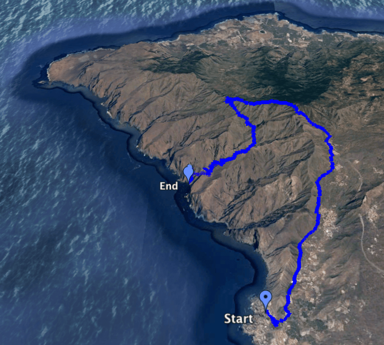
The walk through the Masca Gorge, the Barranco of Masca, is the last and fourth part of a great circular walk. In the first part I presented three hikes in the southwestern Teno mountains of Tenerife. All four hiking tours together result in a great circular hike. And see that the tour is quite big with a total of 23 kilometres. But it can easily be divided into four individual tours. After the first three „part“ hikes it is now the turn of the fourth, last and probably also the most famous section: the Masca Gorge. Map
Before I describe the last part of the tour, here are the most important information about the Masca Trail.
General information and hints about the Masca Gorge, the Barranco of Masca
Starting and/or boarding points for the tour
Port of Los Gigantes
Arrival by car: park by the road in Los Gigantes or in the neighbouring district of Puerto de Santiago. If you can’t find a parking space at the side of the road, there is also a parking garage in Puerto de Santiago, Calle de Hondura or parking spaces with costs in the harbour of Los Gigantes.
By bus: bus line Titsa 325 (Puerto de la Cruz-Los Gigantes), lines 462, 493, 494 (Guía de Isora – Los Gigantes), lines 473, 477 (Los Christianos-Los Gigantes), where 477 travels directly and thus faster. Further information you will find on Titsa Homepage. Masca
Parking at the road Buenavista-Santiago del Teide TF 436
Arrival by car: TF 436, parking at the roadside in Masca. The road from Buenavista to Santiago del Teide is narrow and steep and nowadays more and more busy.

road to Masca
Since more and more people want to see the well-known place Masca, there is a lot of traffic (cars and buses) from 9.00 o’clock in the morning. Bus traffic and oncoming vehicles require high attention of the driver. From 10.00 a.m. onwards, all parking spaces in Masca are usually occupied. Then it only helps to park at more distant places on the street.
By bus: 355 (Buenavista-Santiago del Teide) – for more information look on the Titsa Homepage. Arrival by taxi: an arrival by taxi is of course possible everywhere. But in connection with the hike through the Masca Gorge, in Los Gigantes taxi rides to Masca are offered for about 24 € ( 2017), so that interested parties can then hike down the Masca Gorge and return by boat.
Masca beach
In the past, it was possible to get there by boat from Los Gigantes. The first boat left Los Gigantes for Masca in the morning at 9.30 am. The last boat from Masca beach to Los Gigantes left at 5.30pm in summer and 4.30pm in winter. Please note that the Barranco of Masca was closed from February 2018 to March 2021. Now it is only accessible on weekends for booked walks. Boats are not running at the moment (March 2022). Therefore, you can’t do this tour as a circular walk at the moment and you can’t go by boat from Los Gigantes at the moment. You can find more information here. Hopefully this will be possible again soon. Route length and altitude difference
Length of route Masca – Masca beach: approx. 4.5 km
Difference in altitude: 650 m altitude difference
Requirements, weather and clothing
Masca downhill can basically do anyone. But there is a bit of scrambling over rocks and through rock gorges on this section.
In the winter months it can get cloudy, windy or even wet for over 500 metres of altitude. Therefore, you should bring a warm jacket and possibly a rain jacket with you during this time. Hiking boots should already be there and are especially necessary for the Masca Gorge. In the Barranco Masca there is more or less water depending on the weather, so that after snow melting on the Teide and long rainy seasons higher water levels can be expected. This means that from time to time you will have to cross smaller pools and watercourses on potentially slippery stones.
Refreshments and water
There are plenty of places to stop (restaurants, bars, cafés) in Los Gigantes and Masca. Nevertheless, always have enough water with you for the tour. Soft drinks are sold on the beach of Masca.
Possible combinations

Masca gorge - hiking route starting point in Masca
Article summary and large selection of GPS hiking tracks
Sign up for my newsletter now and get exclusive access to my collected GPS tracks as well as all the brief information about my articles.
Sign up nowThe Masca Gorge can be walked downwards or upwards. If you are a bit fit, you can easily walk up and down the Masca Gorge in one day. Then he can arrive and depart by boat from Los Gigantes.
Hike from Masca to the beach and on to Los Gigantes
Information about Masca and the gorge
Why the Masca Gorge of all places?
A lot has already been written about the Barranco of Masca. It is the gorge through which almost every tourist who wants to hike on the island goes. There are already big hints to the gorge at the airport and almost in front of every shop that offers tours on Tenerife. Every trekking and hiking company in Tenerife specializes in hiking through the Masca Gorge. And thus it is not surprising that already in the morning from 10.00 o’clock the small place Masca is full of people. And on the narrow access road a small traffic jam can form at this time.

Masca gorge nature
The Masca Gorge is admittedly wildly romantic and more than impressive. But there are similar gorges nearby that are in no way inferior to the Masca Barranco. I will write about it in a separate article. What is the reason, that apparently everyone who wants to hike a little is walking through the Masca Gorge? Why do the tour providers offer Masca and not the Barranco Seco? The answer is simple. Only the Masca Gorge is approached by boats at its end. This makes it possible to run down the gorge and then return by boat.
Therefore
For this reason, all providers and also most individual tourists like to hike from Masca down the Barranco to Masca Beach. In the other direction, up the gorge, there are only a few hikers. Even fewer people do the Barranco up and down in one day. In every other Barranco on the island, the one that walks down it has to climb again afterwards. And so it happens that the gorge of Masca is filled daily with people of all nations. Due to the many groups, the rocky bottlenecks in the gorge are often filled with people. At the moment there are therefore already considerations to make the passage through the Barranco chargeable.
Masca without crowds of people

Masca gorge - hikers in a narrow part of the barranco
Thus, those who want to enjoy the gorge of Masca in some more silence should start the hiking tour from the place Masca to the beach between 8 and 9 a.m., if possible before the big crowd. When I once walked through the Barranco at 8.30 a.m., I just met three people. Another possibility to escape the crowds is to take the first boat from Los Gigantes to Masca at 9.30 in the morning. Then the Masca beach, which is full of people in the afternoon, is still absolutely lonely and empty.
When the boat drops off the first hikers in the morning, there are no more than 5 people on the beach. Everything seems peaceful and almost deserted. When you then walk up the Barranco, you have about 1.5 hours of absolute rest before the first groups of people from above meet you. If you – as I like to do – walk down the Barranco again afterwards, you will meet more people than on the ascent. But it won’t be the crowds that go down the gorge late in the morning.
Masca alone or with a provider?
If you do not want to go alone, but with a tour operator, your journey to Masca will be organized and you will receive interesting information on the spot. However, you will only find a limited amount of peace and nature, as almost all the groups start their descent together between 10am and 11am. If you prefer to walk alone, this is also possible. Because you can’t really get lost in the narrow Barranco. In the upper part of the gorge you can see the path very clearly. But then in the lower and middle part there are different possibilities from time to time.
Although in a few places you can get a little lost, because the path in the lower part of the gorge is not always clear.

Masca gorge cairn figures
But nothing can happen, because the „wrong“ way ends very fast and you can always orientate yourself at the very close rock faces of the gorge. In addition, the Barranco Masca has been „numbered“ with small yellow signs for some years now. The numbering starts at the top of Masca. You will find the last small sign with the number 56 on the beach. If you hike up Masca, the numbers can motivate you. „Ah ha, already 32. Then it can’t be that far,‘ I hear someone say every now and then on the way up.
Time and length of the hike through the Masca Gorge
The distance is about 4.5 kilometres and there are about 650 metres (715 absolute metres) of altitude to overcome. But don’t underestimate this distance, which is much shorter as the crow flies. From time to time I meet women in heels and ballerinas in the Barranco. And when someone who had an air mattress under his arm recently asked me about the way to the beach, I could hardly believe it. Even without a guide, you should only walk Masca in good weather with appropriate hiking clothes and, above all, sturdy shoes.
One question
When I walk up the Barranco, the oncoming people often ask me about the time. „How far is it to the beach“ is the most frequently asked question. And the answer? Difficult. I’ve seen athletes running up the trail in an hour and others taking their time and taking 5 hours to get there. Therefore, times can only be relative. But on average it takes 2.5 to 3 hours to cover a distance. It is therefore important to plan the descent in such a way that at least the last boat can be reached. If you buy boat tickets beforehand, you will often be asked for your mobile phone number to make sure that all ticket holders actually arrive at the beach. In the gorge itself, however, you can’t make phone calls in many places. There is no mobile phone signal and JPS does not work everywhere.
Hiking route from Masca to the beach
The village of Masca and the pirates

Masca gorge - the way through the village
The famous Masca Trail, as mentioned at the beginning, can of course also be used as a separate hiking trail in any direction and also up and down or vice versa in one day. But in my big Teno circular hike, the route Masca Gorge is integrated down.
After the hike over the Degollada de La Mesa, we arrived at the main road in Masca. The place itself lies between slopes and terraced fields in a volcano crater and consists of approximately 80 houses and approximately 100 inhabitants. If you like, you can also spend the night here and start the hike from Masca (further). But since there are only few overnight accommodations, you should take care of a sleeping place early if you are interested.
The story
The guides who lead the tourists through the gorge often tell that in the 18th and 19th century Masca was a place of refuge from pirates. Masca would be „hidden“ or „masked“. According to another version, the inhabitants themselves were pirates who hid in Masca with their treasures in the mountains. Every tourist guide has his own stories.
We walk the small stone path from the main street past the church square with the big trees. We continue along restaurants, bars and souvenir shops to the entrance of the gorge. This is located on the ridge about 30 metres from the bar there. On the left side there is an opening in the otherwise continuous fence with a sign and warning sign.
Steep descent
Article summary and large selection of GPS hiking tracks
Sign up for my newsletter now and get exclusive access to my collected GPS tracks as well as all the brief information about my articles.
Sign up now
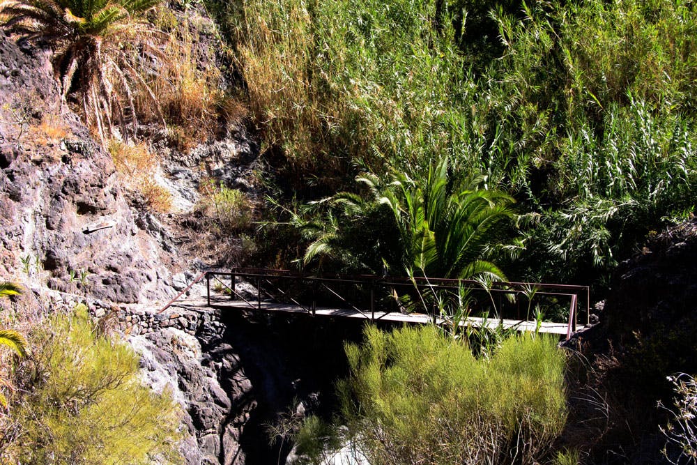
Masca gorge - bridge
The first part down from Masca is also the steepest part of the whole hike. Right at the beginning, you will climb about 100 metres on steps, some of which are fixed with wooden planks. Difficult to climb at the end of the tour. But now you only go downhill on the big circular hike. After a short time you cross a small bridge and cross the Barranco bed for the first time. After the bridge you cross a small rock massif on the right. Shortly after, a path to the left of the main path branches off up the mountain.
There it goes to a Galeria (tunnel), which leads through the mountain into the Barranco Seco. The tunnel is mostly full of water that reaches up to the knee. Therefore rubber boots are necessary or barefoot for those who want to cross it. But this is also a tour of its own. You should keep going down the Barranco on the main path. The place Masca is already high behind you and disappears after some turns of the way completely from the view.
Rocks, reeds and an impressive landscape
The path is easy to find here in the upper part of the gorge and runs along the rocky slope on the left Barranco side. The gorge is still wide and mostly sunny. As you descend, the gorge narrows visibly. The rock walls seem to converge. But there is still a way in between. The gorge with the high lateral rock walls, big stones and a lush vegetation is more than impressive.

Masca gorge - hiking path
Frequently, the path runs over small rivulets, waterholes and between and over rocks. It goes downwards in many turns.
From time to time the path is a bit difficult to find as it runs through reeds and rocks. Depending on the season, the Barranco carries more or less water. If the basins are well filled, it can be a little balancing act from time to time to master the way over the water without wet feet. Slightly exposed areas in the gorge are secured with rope pulls attached to the rocks. There you can hold on tight and get safely over the rocks.

water in the Masca gorge - dogs like it
Number 28
At number 28, half of the way is reached. The Barranco is narrow and shady. But at this point it is also a little flat, so that the large hiking groups often like to have a picnic here. A little further down it goes down through a small rock tunnel that can turn into a waterfall when it rains. There, it can be a little slippery during the descent as also during the ascent. But most of the other narrow rocks in Barranco are easy to bridge. And sometimes there are even two or three ways to avoid the huge boulders that block the way. From time to time the pledge runs to the left and then again on the right side of the Masca Gorge. The whole stony way down to the beach requires a lot of attention and surefootedness.
At the Masca beach

arch made of rocks
At the lower end of the gorge a large rock gate appears on the left side. When you have passed through there, the narrow gorge suddenly continues. If you now listen carefully, you will hear the sound of the Atlantic again in the distance. It goes through a washed-out wide Barranco bed slowly towards the beach. Left and right are the last stones to overcome and in between there is suddenly white sand. Please do not let up with your concentration, because strangely enough most accidents should not happen at the dangerous places in the gorge, but here at the end in the relatively easy terrain.
The end of hike
And then you see a fenced finca on the left side. This is the only inhabited building in the Masca Gorge and on the beach. In front of you is Masca Beach. There it is early in the morning very empty. But then in the afternoon it is crowded with hikers and the daily visitors. For some time now not only the ticket sellers for the boats are sitting under parasols, but there are also cool drinks to buy. If you like, you can take off your hiking boots and take a refreshing swim in the Atlantic Ocean. This is possible on the brick island where the boats moor. There is a ladder into the water. At the very end of the bay there is also a small beach, but it is often washed over by the surf.
Continue to Los Gigantes
When you reach the beach at Masca, you’ve done it. Congratulations. A wonderful hiking day lies behind you, where you walked from the Atlantic coast high up to the highest mountains of the Teno mountains and returned to the Atlantic again through the famous Masca Gorge. Now you can relax on the beach and then take the boat back to the port of Los Gigantes. A last look at the Masca Gorge and then it goes along the impressive rocks. A wonderful end after this intensive day of hiking, which you won’t forget for sure. I wish you a lot of fun and lasting experiences on this beautiful big circular hike through the Teno mountains. I am looking forward to hearing from you and your personal experiences. Maybe we will even meet one day, because this tour is one of my very private favourite tours.
Please note that the Masca Barranco was closed from February 2018 to March 2021. Now it is only accessible on weekends for booked hikes.
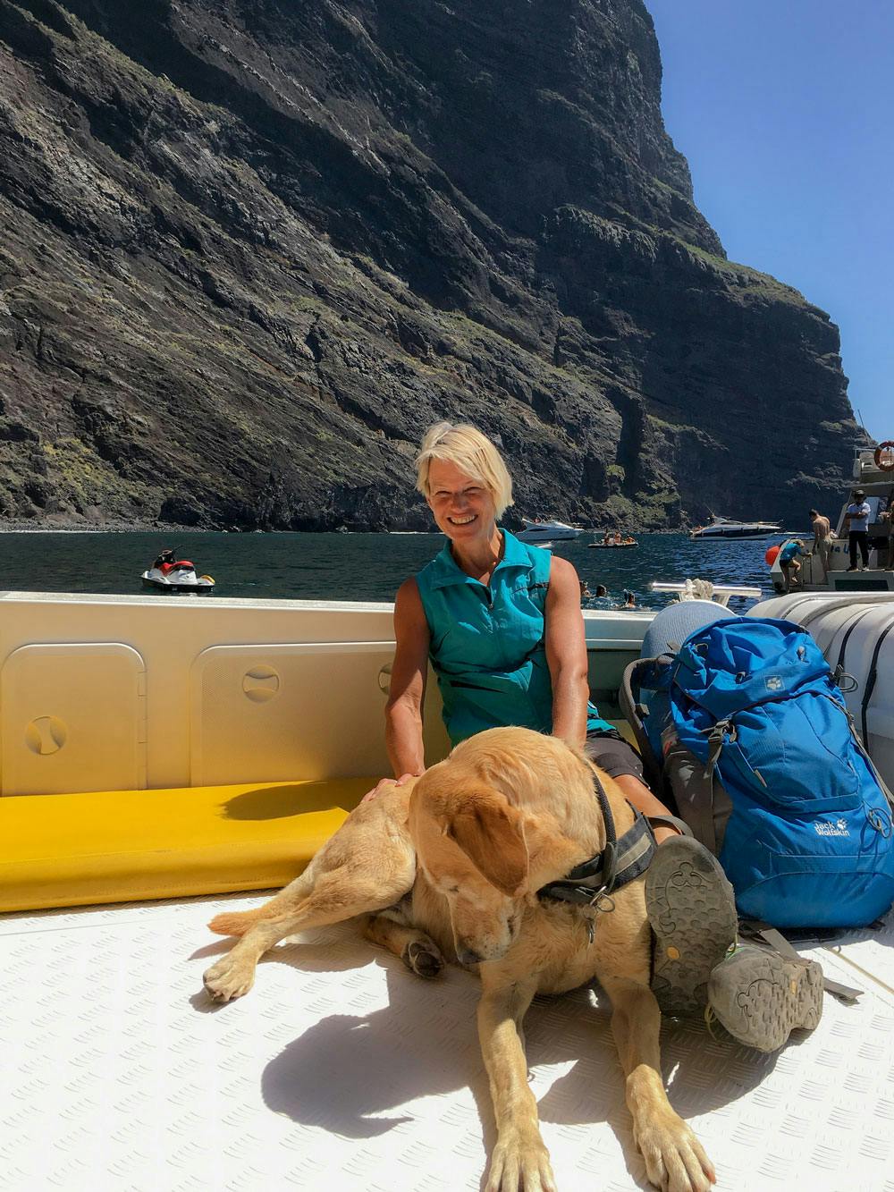
Addendum: On the way with dog
If you are like me with dog on the way, I would like to give you some extra tips. Since it is a quite long hike, it goes without saying that your four-legged friend should be in good condition. In Masca he has to be a little skillful in climbing and not afraid of smooth rocks. By the way, the hike is very suitable for a dog, because the paths on the route sections 1-3 are consistently easy to walk and without any difficulties. Water is also available on the way, so that you don’t have to take any water with you for your dog.
Here are the water points:
First section: A water tap is directly in the lower part of the hiking trail on the left side near a banana plantation. Further up, water flows in a partially uncovered canal.
Second section (short): I haven’t discovered a water hole yet.
Third section: Right at the beginning of the hike there is a water tap on the public picnic place in Santiago del Teide.
Fourth section: Fresh water flows everywhere in the Masca Gorge. The dog can even swim here at any time of the year.
In public buses from Titsa dogs are not allowed. In taxis it depends on the taxi driver. I myself have only had good experiences so far and was also taken along with dogs. On the boats from Los Gigantes to Masca Beach dogs are allowed and are not even charged extra.
And Finally
I hope you enjoyed this great circular walk through the Teno Mountains and Masca Gorge. Please note that the Masca Barranco was closed from February 2018 to March 2021. Now it is only accessible on weekends for booked hikes. You can find more details here. I hope you enjoy your hikes, Dagmar from SiebenInseln