Status November 2022: At the moment, the round trip does not work because the hiking trail between El Molledo and Santiago del Teide is closed due to the construction of the motorway. The route from Santiago del Teide to the Degollada has also been changed due to tunnel construction.
Teno Mountains – four hiking tours and one big circular hike
Track hiking Los Gigantes to Masca
Today I present a big circular walk through the Teno Mountains on Tenerife. It leads through the southwestern part of the Teno Mountains and through the famous Barranco of Masca. I myself love round trips, because there is always something new to see on the whole way and without going back I arrive at the starting point again at the end. But I admit that this tour is really quite big and maybe3t with its approx. 23 kilometres is not necessarily something for everyone. But the good news for you: this big tour can easily be divided into four single hiking tours. Thus, I describe four hiking tours that you can hike individually, together or in different variations.
The first part is about the first three sections. In the second part there is a detailed description and information about the fourth part of the hike.
Map
What is there to see on the big circular hike through the Teno Mountains?
The most famous part of the route takes us to the small village of Masca and through the famous Masca Gorge (Barranco Masca). In another section we climb high above Santiago del Teide to a mountain saddle, the Degollada de la Mesa. From there there is a fantastic view to the Teide and the whole Teno mountains as well as the neighbouring island La Gomera. From there you can also climb the highest mountains of the Teno Mountains, the Small Gala (Pico Verde) and the Big Gala.

degollada between big and little Gala
But also beside these tour highlights there is a lot to see and experience. You get to know the places Los Gigantes, Tamaimo, Santiago del Teide and the small mountain village Masca. The tour takes you from the coast along a camino real through the varied Barranco Santiago and further up to the mossy northern slopes of the Teno Mountains. Finally, we return to the coast through the wild rocky landscape of the Masca Gorge. To relax you can end your trip with a wonderful boat trip along the cliffs from the beach of Masca to the harbor of Los Gigantes.
Before I describe the tour exactly with the individual route sections, here first some important information. These hints will help you to find the individual hiking routes and not to miss anything.
General information and hints for the circular hike through the Teno Mountains
Starting point
Port of Los Gigantes

harbour of Los Gigantes
Arrival by car: park by the road in Los Gigantes or in the neighbouring district of Puerto de Santiago. If you can’t find a parking space at the side of the road, there is also a parking garage in Puerto de Santiago, Calle de Hondura or parking spaces with costs in the harbour of Los Gigantes.
By bus: bus line Titsa 325 (Puerto de la Cruz-Los Gigantes), bus lines 462, 493, 494 (Guía de Isora – Los Gigantes), bus lines 473, 477 (Los Christianos-Los Gigantes); bus line 477 runs directly and is therefore faster – more information on Titsa homepage „Entry points“ for individual route sections of the tour
Tamaimo
Main road TF 454, Carretera Puerto

the village of Tamaimo
Arrival by car: enough parking available at the roadside in Tamaimo
By bus: Titsa Bus lines 325 (Puerto de la Cruz-Los Gigantes), 460 (Icod de los Vinos-Costa Adeje), 462 (Guía de Isora-Los Gigantes)
Santiago del Teide
main road TF 82, Avenida de la Iglesia, diagonally opposite the square in front of the church (large picnic area, recreativa)

chirch of Santiago del Teide
Arrival by car: Parking available at the roadside
By bus: Titsa line 325 (Puerto de la Cruz-Los Gigantes), 460 (Icod de los Vinos-Costa Adeje), 355 (Buenavista-Santiago del Teide), 462 (Guía de Isora-Los Gigantes)
Masca
Parking at the road Buenavista-Santiago del Teide TF 436

street close to Masca
Arrival by car: TF 436, parking at the roadside in Masca. The road from Buenavista to Santiago del Teide is narrow and steep. Since more and more people want to see the well-known place Masca, there is a lot of traffic (cars and buses) from 9.00 o’clock in the morning. Bus traffic and oncoming vehicles require high attention of the driver. From 10.00 a.m. onwards, all parking spaces in Masca are usually occupied. Then it only helps to park at more distant places on the street.
By bus: 355 (Buenavista-Santiago del Teide)
Arrival by taxi: an arrival by taxi is of course possible everywhere. But in connection with the hike through the Masca Gorge in Los Gigantes extra taxi rides to Masca are offered for about 24 € (as of 2017). If a few people come together to hike down the Masca Gorge and return by boat, this is a good alternative.
Masca beach
IMPORTANT NEWIn the past, arrivals by boat from Los Gigantes were possible. There are different companies. The first boat from Los Gigantes to Masca left at 9.30 in the morning. The last boat from Masca beach to Los Gigantes left at 5.30pm in summer and 4.30pm in winter. Tickets could be purchased online and in many shops and stalls in Los Gigantes in and around the harbour. And it was also possible to buy tickets directly on the beach in Masca. Since the closure and reopening of the Barranco of Masca, there are no more boat connections. Possibly one day there will be again. Only then will it be possible to do this tour again as a full round trip.
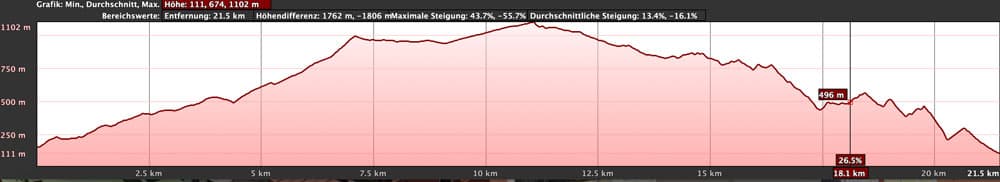
elevation profile Hiking Route Los Gigantes Masca
Route length and altitude difference
Total route length
23 km + boat tour Masca Strand-Los Gigantes (approx. 12 minutes)
Route section Los Gigantes – Tamaimo: from the port approx. 7 km
Section Tamaimo – Santiago del Teide: approx. 4 km
Article summary and large selection of GPS hiking tracks
Sign up for my newsletter now and get exclusive access to my collected GPS tracks as well as all the brief information about my articles.
Sign up nowSection Santiago del Teide – Masca: approx. 7.5 km
Route section Masca – Masca beach: approx. 4.5 kilometres
Note: The kilometre indications on the route sections are only approximate values, which depend on whether the route is used continuously or with detours or „only“ as a partial route.
Difference in altitude
From Los Gigantes port to the Degollada de Mesa 1247 metres altitude difference. Those who want to climb the Small Gala (Pico Verde) with its 1318 metres of altitude difference or the Big Gala with its 1347 metres of altitude difference must therefore add up to 100 metres of altitude difference.
In total (absolute ascent), from the harbor Los Gigantes to the Degollada de Mesa, there are 1296 altitude metres to overcome. From there to the Masca beach, it’s only downhill (apart from very small, insignificant climbs).
Requirements, weather and clothing

La Gomera over the clouds of Teno mountains
Basically, anyone can walk the route. There are no exposed spots or sections that would require absolute freedom from vertigo (exception: ascent of the Little Gala). But if you want to walk the whole route, you should be in quite good condition. If you want to walk sections 1, 2 and 3 individually, you can take it easy and enjoy nature on beautiful hiking trails. Section 4, Masca downhill, can basically be done by anyone. But there is already a little scrambling over rocks and through rock gnawing on this section.
In the winter months it can get cloudy, windy or even wet over 500 metres in altitude. Therefore you should bring a warm jacket and a rain jacket with you. Hiking boots should be already and are especially necessary for the Masca Gorge. In the Barranco Masca there is more or less water depending on the weather, so that after snow melting on the Teide and long rainy seasons higher water levels can be expected. This means that from time to time you will have to cross smaller pools and watercourses on more or less slippery stones.
Refreshments and water
There are plenty of places to stop (restaurants, bars, cafés) in Los Gigantes, Tamaimo, Santiago del Teide and Masca. On Sunday many bars in Tamaimo are closed. There are no places to stop for refreshments on the respective sections of the route. Only at the Mirador Cruz de Hilda, shortly before Masca, the restaurant is open from 8-18.00 o’clock (Friday rest day). And for some time now, cool drinks are also sold at the beach of Masca. Nevertheless I would like to recommend to always have enough water with you.
Variants

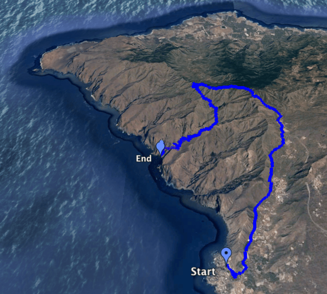
track of the whole roundtrip from Los Gigantes to Masca
You have the choice
As mentioned at the beginning, the tour can be done as a whole or in individual sections. I describe the hike via Los Gigantes, Tamaimo, Santiago del Teide, Masca and back to Los Gigantes. But there is nothing to stop you from doing the tour in the opposite direction. Personally, I think that the tour in the other direction will be a little more exhausting, as it starts with the impassable steep ascent Masca. And also the hike from Masca to the Degollada de la Mesa has some quite steep places. The advantage of this variant is that the boat trip is at the beginning of the hike and nobody has to be afraid to miss the last boat in Masca.
As there are many different hiking routes around Los Gigantes, Tamaimo and Santiago del Teide, it is also possible to combine sections with other tours. To enumerate all these here would go beyond the scope of this hiking description. In another article I will go into detail about the individual tours in the Teno Mountains.
Trip to the Gala summits
From the Degollada de Mesa there is the possibility to make a detour to the Great or the Small Gala. Since both mountains offer a fantastic view in good weather, I can recommend this small extension in any case.
If the tour is too exhausting for you, you can also divide it into three or four hiking tours. Perhaps someone would also like to get to know a section of the route particularly well. Then a hike there and back is the best option. This option is particularly recommended for section 4 (Masca Trail). If you are a bit fit, you can easily walk up and down the Masca Gorge in one day. Then you can take the boat to and from the hiking trail.
There are many possibilities. I wish you lots of fun with your personal Teno round trip.
Teno Mountains – Hike from Los Gigantes to Tamaimo
Information about Los Gigantes and Tamaimo
the habour of Los Gigantes
Los Gigantes
The hike begins and ends at the port of Los Gigantes. Los Gigantes is not a place of its own, but a district of Santiago del Teide. It is located in the west of Tenerife directly at the approx. 500 metre high cliffs, the Acantilados de Los Gigantes. In Los Gigantes there are many holiday flats in which once mainly Britons lived. Even if the English influence is still unmistakable today, you will increasingly hear all other European languages around you.
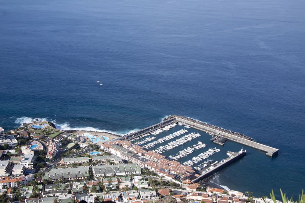
There is a small market square with a church, bars, restaurants and shops. Immediately below the steep cliffs is a 200 metre long fine sandy beach, Playa de los Guíos. A large hotel, which dominates the appearance of the town, was the first building in the town in the 60s of the previous century. The town of Los Gigantes was built around the hotel. The sports and leisure harbor of Los Gigantes is a popular meeting place for strolling and bar visits. From there, various whale watching tours, fishing trips and trips to the Atlantic Ocean start.
Tamaimo

Camino Real at Tamaimo
Tamaimo is a small town in Barranco Santiago, which also belongs to the town of Santiago del Teide. It is located on the road coming from Puerto de Santiago, on the TF 454. In Tamaimo it crosses with the TF 82 coming from Guía de Isora. Tamaimo with its many colorful houses stretches from 400 to 600 metres above sea level. At the main street there are many bars and restaurants, shops, a pharmacy and also a supermarket. Worth seeing is the church Santa Anna with its pretty church square from the 18th century. Around Tamaimo and also between Puerto de Santiago and Tamaimo Canarian bananas are cultivated on many plantations. Tamaimo is also the starting point for many hikes in the Teno mountains.
Tour description from Los Gigantes to Tamaimo

Panorama Los Gigantes
Start in Los Gigantes
The hike starts at the harbor in Los Gigantes or at the bus stop in Los Gigantes or any other place where you parked your car. There are three footpaths out of Los Gigantes. All you have to do is go uphill and out of town. In some places there are also signs for „Salida“ (exit). All three footpaths (two on the road, one on a slope) lead to the main road, Carretera General Puerto de Santiago, TF 454, which you follow straight uphill through a long serpentine. Then you will pass the Mirador Archipenque. From there you have a magnificent view of the rocks and the whole cliffs of Los Gigantes. Continue along the road around a bend and after about 50 metres you will find on your left the PR-TF 65 (white-yellow with information board) to Santiago del Teide.
A small asphalted road climbs steeply uphill and then a few minutes further past some houses and banana plantations. Then the actual royal road (camino real) begins. You will find the king’s way everywhere on the island. They were built in the 17th and 18th centuries to connect the villages on Tenerife.

bananas on the way
Banana plantations and goats
The hiking trail to Tamaimo leads through banana plantations and past a finca and a water reservoir. Then it leads you on wooden steps to a small ridge. You can’t get lost. The path is wide, occasionally paved with large stones and in places a little oily. To the left are the southernmost mountains of the Teno Mountains. At the back of the mountains is Los Gigantes and if you walk higher, the Barranco Seco. On the right side you look back to the coast and above you Tamaimo appears after a short hike.
After about an hour’s walk from the port of Los Gigantes, there is a circular trail on the left side over the Guama River. You continue straight ahead. Then you pass two barracks with a tunnel on the left side and shortly afterwards you go over a goat farm. The path leads you a little steeper towards Tamaimo. There the path changes for some time into the Barranco ground. Now it goes partly over rocks and big stones. From time to time the path changes to the right Barranco side. You leave the village Tamaimo on your right side. If you want to visit the village or end the hike here, there are several signposted paths to get from the hiking trail in a short time to the centre of Tamaimo.
Teno Mountains – Hike from Tamaimo to Santiago del Teide
Information about Santiago del Teide
Article summary and large selection of GPS hiking tracks
Sign up for my newsletter now and get exclusive access to my collected GPS tracks as well as all the brief information about my articles.
Sign up now
Panorama view to Teide high over Santiago del Teide
Santiago del Teide is a small town with over 11,000 inhabitants. The small district town lies on a plain surrounded by fields and vineyards at an altitude of approx. 920 metres. Many tourists drive through this place on the TF 82, if they want to go from the south of the island to the north or vice versa. Also the road to Masca branches off here, so that all Masca tourists from the south and southwest of Tenerife drive through Santiago del Teide. In the northwest of Santiago del Teide is the Teno mountain range. On the opposite side, the geologically much younger parts of the island with the Teide, the Pico Viejo, further volcanoes and the foothills of the Teide National Park. Therefore, it is not surprising that many hiking trails start in Santiago del Teide.
When the nearby volcano Chinyero erupted in 1909, Santiago del Teide was almost buried by the lava flow. But the lava flow stopped shortly before the city in front of the Montaña Bilma. The centre of the little town with its many cafés and restaurants is the village square with church and the statue of a Guanche chief (Guanches are the natives of the Canary Islands). There on the square is also the tourist information. As Santiago is more than 900 metres high, the temperature is often a few degrees colder than on the coast. Often, big cloud bands move over the place, that fog Santiago del Teide a little and then also cover the wonderful view to the Teide.
Tour description from Tamaimo to Santiago del Teide
On the Camino Real direction El Molledo
The hikers who have already completed the first stretch simply continue uphill on the Camino Real towards Santiago del Teide. If you want to start the hike in Tamaimo, start at the main road TF 454 and walk towards the church. Continue straight ahead along Calle Santa Anna. Calle Real is crossed and on the left side there is now a waterhole. When you have passed the waterhole, turn left. After a few metres turn right again into a lane and after that you are already on the access path to Barranco Santiago. After 50 metres you come to the Camino Real and follow it uphill towards Santiago del Teide. It goes along narrow paths at the foot of the ridge to Barranco Seco. On the left there are hiking trails to the Teno mountains. You follow the path straight uphill to Santiago del Teide.

view into the valley of Santiago
First it’s steep and then quite moderate uphill for a while. Shortly before the small village El Molledo the actual Barranco Santiago ends. Now it goes for a short time in narrow serpentines really steeply uphill. You pass a sign indicating the nature reserve.
El Molledo to Santiago del Teide
After that there are only a few metres of altitude left and we made it. Here is a hiking crossroads, where many paths lead to the Barranco Seco and to the Risco Blanco as well as to the place El Molledo. But you simply follow the main path to the right towards Santiago del Teide.
Now it’s only 1.2 kilometres without major climbs. The way runs through fields and leads you finally to the main road Avenida de la Iglesia of the TF 82 in Santiago del Teide. Thus also the 2nd section is finished. Those who like can have a look at Santiago del Teide or have a small rest on the big picnic place (area recreativa) diagonally opposite the church and the church place. Here is also the starting point for the third section.
Teno Mountains – Hike from Santiago del Teide to Masca
Tour description to Degollada de la Mesa
degollada between big and little Gala
We start at the large picnic area on the main road in Santiago del Teide (area recreativa). From there we follow a narrow footpath for a few hundred metres on the TF 82 towards Icod de los Vinos. In a long bend to the right, the signposted PR TF 56 (white yellow signposted) leads you to the left towards Degollada de la Mesa. From Santiago del Teide, the trail climbs 317m on a beautiful path into the Teno mountains. The path first leads through a pine forest, crosses a stream that only carries water during rainy seasons and then meanders comfortably up the mountain on the right side of the gorge.
After about half an hour we cross a wide forest path. If we were to follow this path, we would turn right around the mountain and cross the northern flank to reach the summit of the Great Gala. But we continue straight on the narrow path and after about 20 minutes we reach the Degollada de la Mesa (1247 metres above sea level). From there, there are wonderful views to the Teide and Santiago del Teide. To the west side, the neighbouring island La Gomera and the whole Teno mountains can be seen. Very deep down to the west we can already see the Cruz de Hilda and the surroundings of the place Masca.
Trip to the small one (Pico Verde) and the big Gala

view over the Teno mountains to Masca from Pico Verde
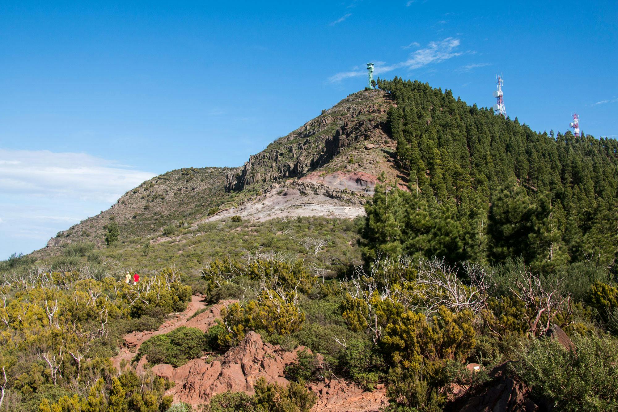
Those who have time and desire should make a detour from here to the Great Gala (1347 metres above sea level) and/or the Small Gala (Pico Verde with 1313 metres above sea level). In the Teno mountains these are the highest peaks you can climb. The Great Gala has a fire tower and transmitter masts on its top. The more daring can climb the summit straight from Degollada through the terrain. However, the normal path continues towards Masca and after a while turns off to the right. Those who only want to walk this 3rd section can make this detour without further ado.
Those who want to go the whole tour will probably not have time for it on this day. But a short excursion to the Small Gala (Pico Verde) is always possible. It takes maybe 15 minutes in the ascent and 10 minutes in the descent. At the end, the path that leads uphill to the left of the Degollada de la Mesa is a little scrambly. Here the hiker should be sure-footed and free of vertigo. But the ascent is rewarded with a fantastic panorama. The Teno mountain range spreads out in front of us. The Teide and often the whole south coast can be seen from up there. Really worth it. In fog, rain, storm and clouds this ascent will be omitted, because there will be no visibility anyway.
Tour description to Masca

cloud catcher
Bellflowers and cloud catchers
Those who want to make the big round tour through the southwestern Teno mountains can now breathe a sigh of relief, as the highest point of the hiking tour is reached. From now on it goes only downhill. First we follow the PR TF 51 gently downhill along the slope. In spring the Canarian bellflowers bloom bright yellow. But beside the colorful flora we have wonderful views of the Teno mountains and the neighbouring island La Gomera. Also the place Masca can be seen below in the distance bit by bit more and more.

view to the north cost of Tenerife
After approximately one kilometre we pass the Cumbre Bolico and cloud catchers. The cloud catchers are placed there on the north side of the mountain slope to catch water from the clouds. A few minutes later we arrive at a kind of place with a ruin, from which several hiking trails start. On the left side there is an old threshing place – an ideal sheltered place for a picnic with a wonderful view.

view from the ridge on the way from Gala to Cruz de Hilda
A detour into the cloud forests of the north
We follow the PR TF 51 over the Tabaiba Pass towards Teno Alto. On the left we have a beautiful view of the southwestern part of the Teno Mountains, while on the right we can look north. El Palmar and the coastal region gradually become visible. The way goes sometimes leisurely and then again steeply downhill. Mostly it runs on the right side of the pass through the northern cloud forest. Here ferns and mosses hang down from the trees.

view to the north side of the Teno mountains
Everything is green, which indicates a lot of humidity and rain. If you step out of the wooded sections, you will still have fantastic views. From time to time we go uphill on short sections, then downhill again. The trail runs partly northwards and leads in a wide arc from Degollada de la Mesa down towards Masca.

old treshing place on the way
Downhill to Cruz de Hilda
After the ridge walk is finished, we are at a crossroads (Cumbre del Carrizal). Here we turn right on the PR TF 59 to Las Portelas in the north of the island and straight on on the PR TF 51 to Teno Alto. However, on this itinerary we take the PR TF 59 to the left towards Masca. Up to the Cruz de Hilda it goes now in wide serpentines on a mostly wide footpath downhill. On the right there is more and more the road from Buenavista to Masca, the TF 436 in sight. We look at the coasts and the small place Carrizal.

Cruz de Hilda
The Cruz de Hilda lies at an altitude of 780 metres. Here we are again at the and if not straight Friday is, can be stopped in the restaurant also. On the left, a small road leads down to the Mirador, signposted. After a short time, the hiking path goes down from this road to the right and leads us in small serpentines steeply down the mountain. It passes houses, gardens and vineyards.
Arrival in the village of Masca
After approx. 20 minutes we arrive in Masca in the district Vica on the TF 436. Now we have to walk a few hundred metres along the road to the capital Masca. Those who have felt a little lonely on this hike until now, as they have met only a few people, will be happy now. Because in Masca he is surrounded by crowds. But first you can be happy about something else. Because the third stage has also been completed. Now only the gorge (the Barranco) of Masca is missing.

Bar Restaurant in Masca
Finally
I hope you’ve enjoyed the hike so far. If you are interested in the last and most famous part of this hike through the Teno Mountains, you can read all about Tenerife’s most famous gorge hike in the second part here. Please note that the Masca Barranco was closed from February 2018 to March 2021. Now it is only accessible on weekends for booked hikes. Boats are not running at the moment (March 2022). Therefore, you cannot do this tour as a circular walk at the moment. Have fun hiking,
Dagmar from SiebenInseln

view into the Masca gorge