At the beginning of January 2026, I heard from hikers that the trail was closed. However, there is apparently only a prohibition sign at the top of the road.
From Güímar via Pico Cho Marcial to Cumbre Dorsal
The hike around Pico Cho Marcial, which starts above the village of Güímar, is quite a strenuous hike with some minor climbing. It is therefore not suitable for everyone. You need to be in very good physical condition and be sure-footed and free from vertigo. But if you have these qualities, you will enjoy this exceptionally varied hike.
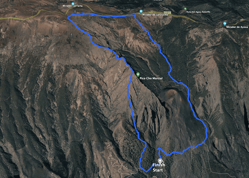
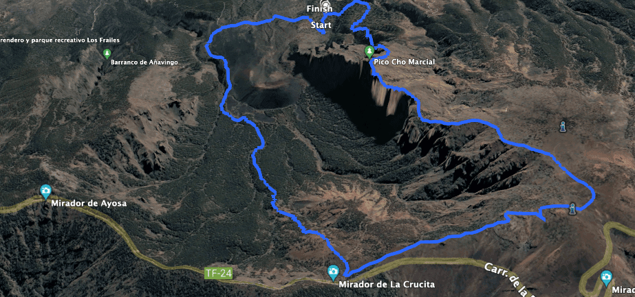
Map

View of a rock gate from the ascent path
Güímar, with its 20,000 inhabitants, is famous for its pyramids, which for a long time were said to be the work of the Guanches or even to have come from extraterrestrials. In fact, however, they date from the 19th century. Tourists still come to look.

View of the Teide from the hiking trail on the Cumbre Dorsal of Tenerife
Hikers know Güímar through the fantastic tunnel hike Ventanas de Güímar. But today’s hike takes you much further up into the heights of Tenerife to Cumbre Dorsal. 
Descent path towards Güimar
Pico Cho Marcial, Cumbre Dorsal and the Arafo Volcano
You start this hike at an altitude of about 1,100 metres above Güímar and reach Pico Cho Marcial at an altitude of just under 2,000 metres. Until then, it is a steep climb through the forest. Later, the route goes straight uphill in rocky terrain with small climbing sections. From Pico Cho Marcial you already have wonderful views. But the ascent is far from over. The route continues uphill along the mountain ridge until you reach the highest point of the hike on Tenerife’s mountain ridge, the Cumbre Dorsal, at an altitude of approx. 2280 metres.

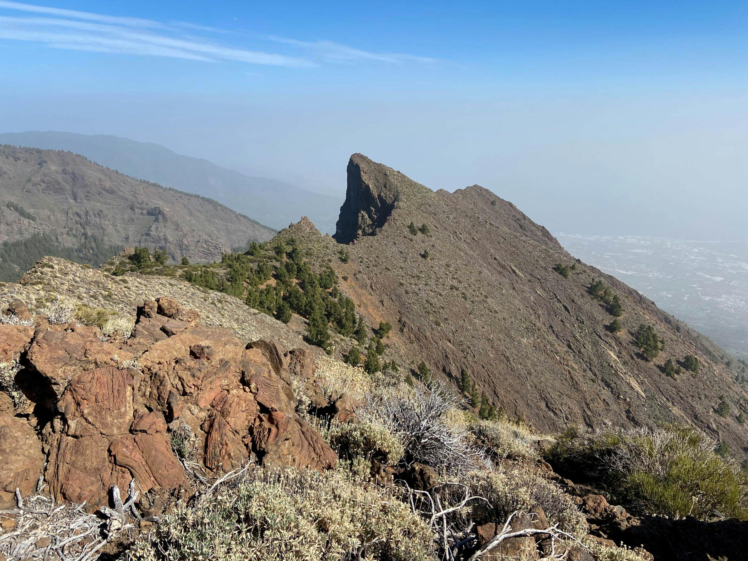
View of the rock massif around Pico Cho Marcial from the ascent trail
From there, the trail finally descends to the Mirador de La Crucita. Immediately at the Mirador, you will meet the pilgrims‘ path down towards Güímar. Another highlight awaits you on the way back. When you cross the Caldera de Pedro Gil, you will pass the Arafo volcano. This volcano, Montaña de Las Arenitas, erupted in 1705 and its smoke clouds are said to have reached a length of 12 kilometres. You will hike around the volcano on two sides before finally – and probably a little tired – returning to the starting point.
Track Pico Cho Marcial seen from the east
General information about the circular hike around Pico Cho Marcial

Start and end of the round trip Pico Cho Marcial
Starting point and approach
You start this hike on a small road high above Güímar at about 1100 metres altitude.
The coordinates are:
28.331817, -16.451399
Here, the road straight ahead is blocked by a barrier and a wide forest path branches off to the left.
Access by car
To get to Güímar, take the TF-1 and exit at junction 22. First drive through Güímar on the TF-61 and keep going uphill from the church Iglesia de San Pedro. An exact description of the route is not possible at this point, but with the coordinates you should find the way. You drive to the starting point of the hike via a narrow asphalt road. This leads steeply uphill in serpentines. Eventually you come to a place where the way straight ahead is blocked by a barrier. Here you can park at the side of the road.
Article summary and large selection of GPS hiking tracks
Sign up for my newsletter now and get exclusive access to my collected GPS tracks as well as all the brief information about my articles.
Sign up nowAccess by bus
The Titsa bus lines 111, 120, 121 and 128 stop in Güímar. You can find more information on the Titsa homepage. But if you get off here, you have another 4 kilometres to walk uphill and downhill. This could be very difficult for this long hike. Possibly, without your own car, a taxi is a good solution. Time
I don’t like to give general times for walking tours, as times are very individual. We needed 6.5 hours for this tour with an extensive rest at the summit. However, we walked this hike at quite a brisk pace, so you might want to allow a little more time.
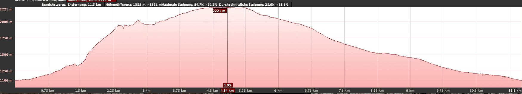
Altitude Profile Pico Cho Marcial
Difference in altitude and distance:
The difference in altitude is about 1,200 metres and a bit more gross. The distance is about 14 kilometres (if you go up from Güímar it is 22 kilometres).

Marking pilgrimage route
Requirement
A very difficult tour with small climbs, which is really not suitable for everyone. You must be in very good physical condition. Surefootedness and a head for heights are absolute prerequisites. This information applies to the ascent to Pico Cho Marcial. The way back on the pilgrims‘ path can be described as easy.
Refreshments
There are no restaurants, bars or shops along the entire trail. Therefore, take enough water and, if necessary, food with you.
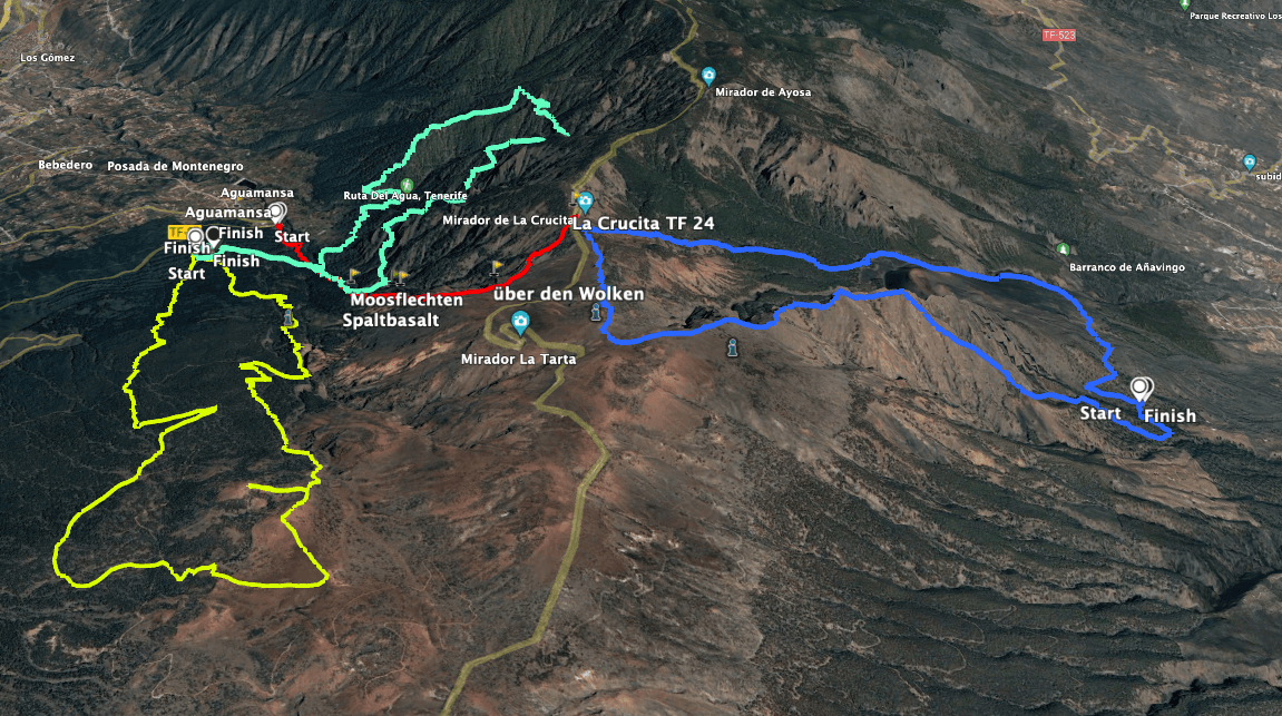
Circular Pico Cho Marcial (blue), Aguamansa - Crucita (red), Organos (green), Caldera - Montaña Limon (yellow)
Variants
This tour can be shortened or lengthened a little. One way to extend it is to start in Güímar and walk another 8 kilometres. You can shorten it by only doing the ascent and having friends or a taxi pick you up at the top. The pilgrimage route past the imposing Arafo volcano is easier. If you don’t want to do the steep climb to Pico Cho Marcial, you can also choose the way back as the way there and walk up and/or down as you like. This tour can also be combined with the continuation of the pilgrims‘ path from Aguamansa to Mirador La Crucita. I will also post the hike here on Seven Islands soon.
If you want to do the whole loop, I can only recommend that you also do it to the left. Then you first have the difficult ascent and then the easy descent. In addition, I can imagine the descent from Pico Cho Marcial being much more difficult than the ascent, as the path is not always easy to find.
Track Pico Cho Marcial seen from the northwest
Circular hike around Pico Cho Marcial
Route section starting point via Güímar to ridge below Pico Cho Marcial
You start your hike at the starting point described above in front of the barrier. You will pass through the barrier on your way back. Now keep to the left on the forest path. You will first cross the Barranco de Valle. Then continue uphill on the wide forest path through the pine forest. Shortly before you reach the Barranco Tamay, a path leads you steeply up into the forest to the right. You will reach a ridge above the Barranco de Valle. From here, follow this ridge path that leads you steeply upwards.

Hikers climbing Pico Cho Marcial
High above you, you can already see the huge rock massif around Pico Cho Marcial. On the other side of the Barranco de Valle you can also enjoy the view of huge rocks and a large rock gate. If you look at my track picture, it is not quite correct at this point. The JPS has taken a „shortcut“. It looks like you are walking across the barranco. In fact, however, the path continues along the ridge. So all in all, it’s a slightly larger arc than you see in the track picture. Here you already have the most beautiful views back to Güímar and up to the rock massif around Pico Cho Marcial.

Ascent path - in the background the rock massif around Pico Cho Marcial
Article summary and large selection of GPS hiking tracks
Sign up for my newsletter now and get exclusive access to my collected GPS tracks as well as all the brief information about my articles.
Sign up nowRoute section ridge below to summit of Pico Cho Marcial
At some point, the forest on the ridge path thins out more and more. You walk through a hollow. For a short time you walk up in the forest on very steep serpentine paths. Then you are out of the forest and a barren rocky landscape surrounds you. From here on, the path climbs even steeper on very narrow paths. From time to time there is no path to be seen. You can orientate yourself a little by the cairns you come across from time to time. Since you are more or less on a ridge, the way up is clear. In some places you will find a small path, in other places you will walk without a path over loose scree, stones and rocks.

Steep climb up the rocks in front of Pico Cho Marcial
Make sure that the stones and rocks you hold on to are firm and really hold you. It will be exhausting. But above you, you can already see Pico Cho Marcial. But before you reach it, you first reach a small pre-peak. Here, stones are piled up to form a wall. Possibly a small protective wall. And of course you have a fantastic view from here. From this summit you follow the ridge. First the small path runs almost at the same height. Then you go downhill for a while and cross a larger gully. On the other side of the gully, the actual ascent to Pico Cho Marcial begins. Partly impassable, partly on small paths and with the help of cairns you will find the way to the summit at about 2,000 metres altitude.

Pico Cho Marcial from the heights
Route section Pico Cho Marcial summit to Mirador La Crucita
On the unusually shaped summit of Pico Cho Marcial you can really enjoy the view in all directions. The view down into the Pedro Gil caldera with the Arafo volcano is impressive. After a short rest on the summit, you can continue your descent from Pico Cho Marcial along the ridge. At first, the path descends close to the ridge. Then the path takes you further down the rocky massif on the side of the slope. In a small hollow you cross a small forest and have lost maybe 50-80 metres in altitude by then. But after that the steep ascent continues.
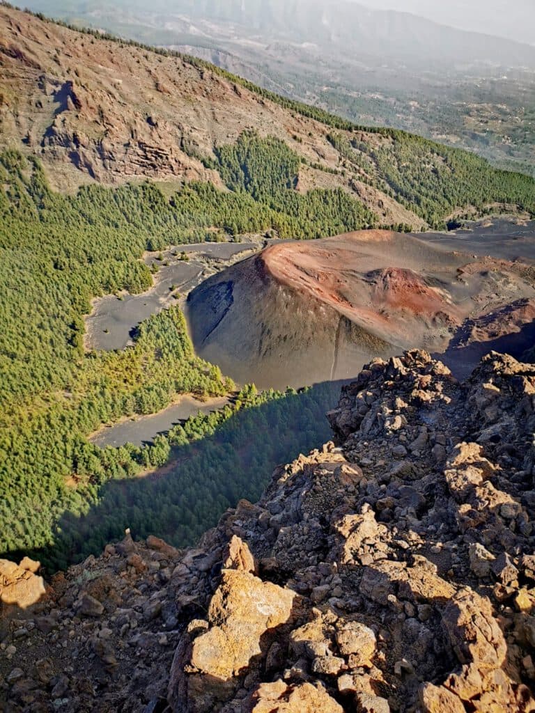
Vulcan Montaña de los Arenitas vom Pico Cho Marcial
You continue to follow the stony ridge path upwards. At times the ascent may seem endless. But at about 2,200 metres you have made it. You reach a wide road that leads you high above the TF-24 on the Cumbre Dorsal of Tenerife. From here on, it’s more or less downhill. On the mountain ridge, the route runs parallel to the road and later descends in steep, bumpy serpentines towards the TF-24. You come out just before the Mirador de La Crucita at an altitude of 2,000 metres. Here you will join the pilgrimage route from the Orotava Valley to Candelaria.

View of Tenerife's Cumbre Dorsal from the ridge path
Route section Mirador La Crucita to Arafo volcano, Montaña de Las Arenitas
The way back on the pilgrims‘ path from Mirador La Crucita is a „walk in the park“ compared to the ascent. You walk downhill towards Güímar on wide or at least well-maintained hiking trails. From time to time, the trail crosses dirt roads. Then the path, marked with a white sign for pilgrims, continues on the other side of the track. Steps are often built into the path. You will quickly lose altitude. For a long time you walk through woodland.

Hiker on the pilgrimage path near Mirador Crucita (descent towards Güimar)
But as you approach the volcano of Arafo, the Montaña de Las Arenitas, you come out of the forest. Slowly, the forest path turns into a volcanic landscape. The volcano rises darkly to your right, and behind it you can see the rocky massif with Pico Cho Marcial once again. It seems to be so high above you that it is hard to imagine that you were sitting on the summit just a short time ago. Now, however, you are hiking through a barren volcanic landscape far below the high peaks.

Pico Cho Marcial and surrounding massif as seen from the descent path
Route Section Arafo Volcano, Montaña de Las Arenitas to starting point
For quite a while, you continue to hike downhill on the excellent (in both senses of the word) pilgrim’s path. But watch out. Before you reach Güímar, you have to turn right under the volcano. You leave the pilgrims‘ path and walk along a wide road below the volcano. The path follows the slope of the volcano in wide arcs, first over lava rock and black sand.

Hikers on the descent path at the volcano Montaña de las Arenitas
Then you enter the forest again and cross a small ridge. Above the Barranco de Valle, the path turns left downwards into the forest. Now it is only a short distance to the starting point, where your car is already waiting for you.

View back from the ascent path towards Güimar (here unfortunately at Calima)
And finally
I hope you enjoyed this exciting hike around Pico de Marcial. The ascent is more than strenuous, while the descent is really easy. If you really want to hike the whole loop, I can only recommend that you also go around to the left. The descent via Pico de Marcial is probably much more difficult than the ascent. I wish you lots of fun on all your hikes,
Dagmar from SiebenInseln