Viewpoint Pico del Inglés
Pico del Inglés is 967 metres above sea level, very close to the main Anaga ridge. It can be reached from the TF-12 and is a popular lookout point. Wonderful hikes – such as the one towards the coast around the capital Santa Cruz de Tenerife – also start here.
Map
From the vantage point, which you should definitely visit before or after the hike, you have a wonderful view across to the centre of the island and to the Teide. The coast with Santa Cruz de Tenerife is also at your feet.
But also the other side of the Anaga with the gorge around Afur and magnificent views of the jagged heights of the Anaga Mountains and the north coast can be admired from the heights. The prerequisite, however, is a clear day without large cloud fields. Below you will also see the Tahodio Gorge with its reservoir and the Barranco de Valle Luis. This circular walk will take you down each side of a large rock massif through both gorges to the coast and back up to Pico del Inglés.

View from Los Berros to the Fortaleza and the Barranco de Valle Luis
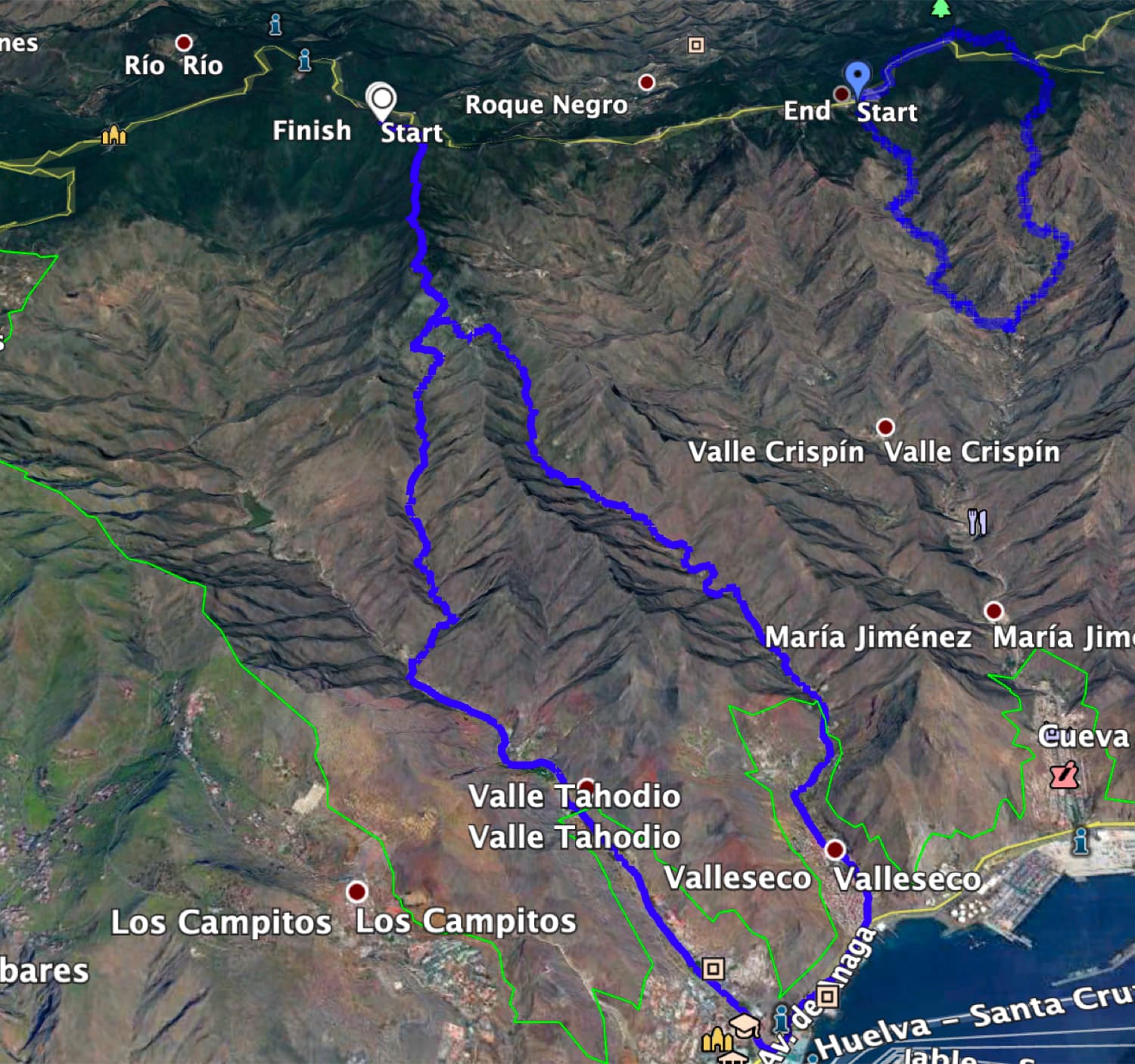
Circular hike from Pico del Inglés via Valle Seco, Valle Tohodio and the Barranco de Valle Luis
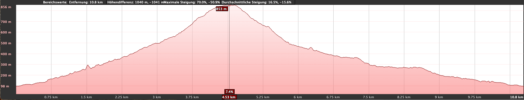
The hike from Pico del Inglés down to the coast to Santa Cruz de Tenerife is over 1000 metres in altitude and just over 20 kilometres long. Therefore, you should be in good physical condition. Or you can walk only one way and then take the bus back. I also present other options for shortening this wonderful hike under Variants.

View over the Anaga Heights from the hiking trail - near Pico del Ingles
However, the entire tour leads you from Pico del Ingles down through the laurel forest to the small farmstead Los Berros. From here, the hiking trail takes you in a curve to the left of the mountain range into the Valle Seco. You hike down this valley to the coast near Santa Cruz de Tenerife. There you bypass the mountain range and hike uphill again in Valle Tohodio and Barranco de Valle Luis. At the farm Los Berros you will meet up with your outward route. From here you return to Pico del Inglés.
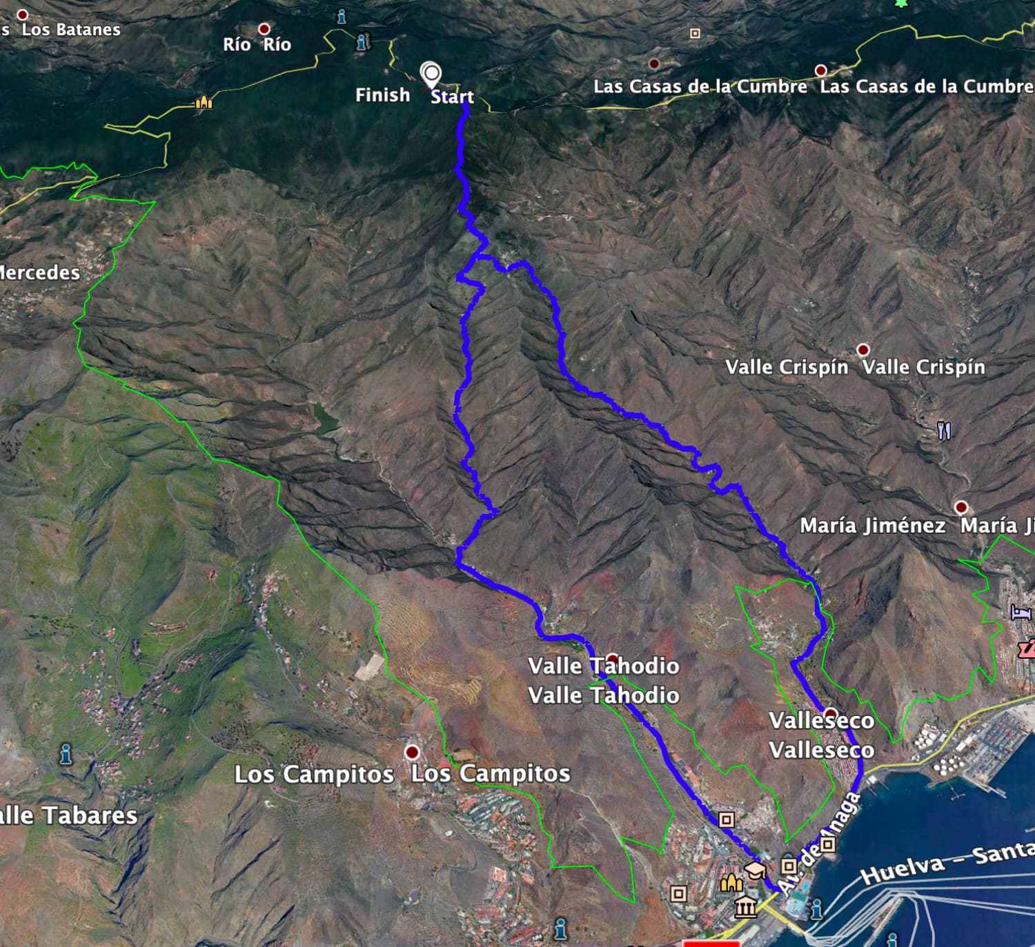
Track of the hike Pico del Ingles - Santa Cruz de Tenerife
General information about the circular walk from Pico del Inglés to the coast
Starting point and access
The hike starts directly at the car park on Pico del Inglés. This is at the end of the TF-114 road.
Access by car
Take the TF-12 from La Laguna to the Anaga mountain road. Once you have passed Cruz del Carmen, the TF-114 turns off on the right after a short while. This will take you to the Mirador Pico del Inglés in no time. It is located at the end of the road at a turning circle. Parking is available there.
Getting there by bus
The Titsa bus line 273 stops at Pico del Inglés. For more information and bus connections from Santa Cruz de Tenerife, check the homepage . Time
I don’t like to give general times for walking tours, as times are very individual. We needed just over 6 hours for this tour with some nice photo breaks and rest.
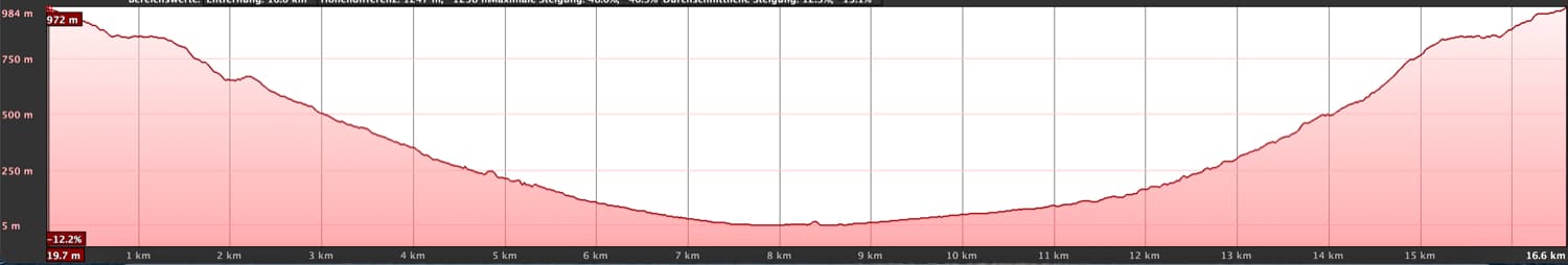
Altitude profile of the hike from Pico del Ingles to Santa Cruz de Tenerife
Article summary and large selection of GPS hiking tracks
Sign up for my newsletter now and get exclusive access to my collected GPS tracks as well as all the brief information about my articles.
Sign up nowDifference in altitude and distance
The difference in altitude is about 1000 metres and about 1200 metres gross in ascent and descent. The route is just over 20 kilometres long.
Requirement
A sporty tour for which a good level of fitness is a prerequisite. But if you don’t want to walk straight from the Anaga height to the coast and back, you can also do only one way or shorten the tour otherwise (see under variants).
Refreshments
Restaurants, bars and shops are only available in Santa Cruz de Tenerife. Therefore, be sure to take enough water and, if necessary, food with you for the hike.

at the Tahodio Reservoir
Variants
This tour is quite long with a length of more than 20 kilometres and approx. 1200 metres in altitude. Of course, you can also walk any route through Valle Seco or Valle Tohodio as well as the Barranco de Valle Luis as an easy ascent or descent. Then you can take the bus to the starting point or, if you have the car there, return there by bus.

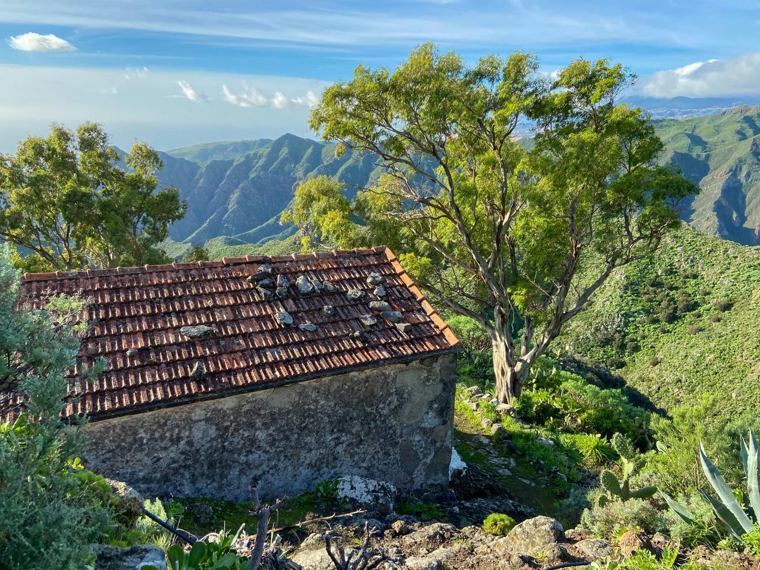
Farm by the wayside - Los Berros
Another option to shorten the route a little is to take one of the two ascent routes in Santa Cruz de Tenerife. In this case, however, you don’t go all the way up to Pico del Inglés, but only as far as the Los Berros farmstead. There you take the descent route and go back to Santa Cruz de Tenerife.
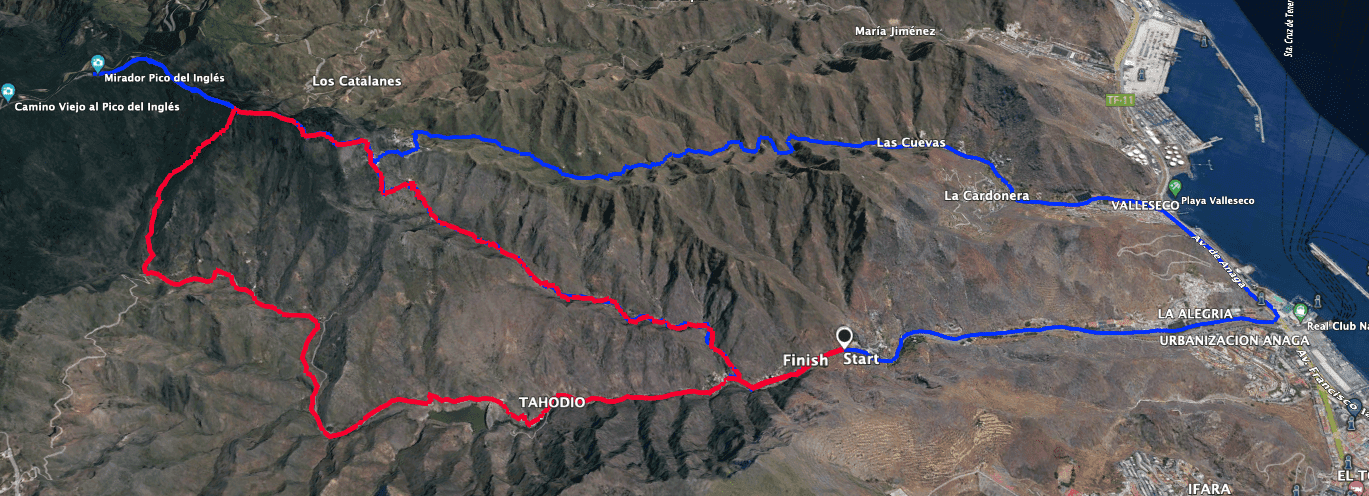
Track of the hikes Pico Inglés to Santa Cruz (blue) and through Valle Luis over the Tahodio reservoir (red)
Elevation profile of the hike across the Tahodio Reservoir
Another option is the hike marked in red in the picture. Then you start above Santa Cruz and hike down below Pico Inglés into the Valle Tahodio. This takes you past the large reservoir. This tour is just under 14 kilometres long and you have to climb 780 metres in altitude. You should plan about 5 hours for this hike.
Tracks of the hike Pico del Ingles - Santa Cruz de Tenerife and Valle Brosque (right)
If the hike is still too long for you and you would like to hike on this slope of the Anaga above Santa Cruz de Tenerife, you can also do the small circular hike into the Valle Brosque. 
Wanderweg hinab in das Valle Seco
Circular hike Pico del Inglés – Santa Cruz de Tenerife
Pico del Ingles section to Los Berros farmstead
After enjoying the beautiful views at the Mirador Pico del Inglés, you descend into the laurel forest on hiking trail PR-TF 2. The trail is marked in yellow and white as far as Santa Cruz de Tenerife. Ignore the paths that branch off from the main path at the beginning and continue straight ahead over an elongated ridge through the dense laurel forest. From time to time you can enjoy beautiful views to the left or right. You will slowly lose metres in altitude on this path over the ridge.

Cave stables at the Los Berros homestead
Finally, the path turns away from the ridge and continues on the right side of the slope. To the right, you have more and more beautiful views of the Teide, as you now slowly leave the laurel forest. On good hiking trails, some of which are quite steep, you will quickly lose altitude. After a descent over small serpentines, you will pass cave stables. Now you are already directly above the lonely Los Berros farmstead. Here the trails separate, so you can go down through one valley and climb back up in the other.

the lonely farmstead Los Berros - the PR TF-2 runs directly along the house
Article summary and large selection of GPS hiking tracks
Sign up for my newsletter now and get exclusive access to my collected GPS tracks as well as all the brief information about my articles.
Sign up nowLos Berros farmstead to Barranco Seco section
Immediately above the homestead, someone has put up two white signposts with directions for the different trails, so you can’t miss the one you want. I chose the descent via Valle Seco. To do this, keep to the left and walk between the houses along a path towards Catalanes. After a while you will come to a junction with the houses you see in front of you on the hill. Shortly afterwards, leave the path to Catalanes and turn right on PR-TF2 towards Valle Seco.

Hike designation at Los Berros
You will now descend into the Barranco Valle Seco. From here you will have beautiful views of the slopes, isolated farmsteads and the Atlantic Ocean in front of you. You can’t miss the path. It runs first on the right, later on the left side of the barranco. Every now and then you cross the bottom and shortly afterwards climb up again a little on the slope. In terms of scenery, this hiking trail with its diverse nature is truly an experience of its own kind. Even though you continue to lose altitude, the path still stretches all the way to the coast.

Hiking trail in the Valle Seco
Barranco Seco to Santa Cruz de Tenerife section
As you slowly approach the coast, you will increasingly come across individual farmsteads and terraced fields. The bed of the Barranco is used for agriculture. The path also leads you past an aqueduct that spans the gorge. At first, you will only pass a few farmsteads. Then you walk through the small village of Las Cuevas and meet a road there. The hiking trail in the lower part of the gorge runs along the Camino de los Naranjos Agrios. The road continues towards the coast below the village of La Cardonera.

Aqueduct in the Valle Seco
Now the road is called Avenida Virgin del Valle. And then you walk through the larger village of Valleseco. At the end of the road, continue along the road towards the sea, which after a short while brings you to the large coastal road, Avenida de Anaga. Now you have made your way to the coast in Santa Cruz de Tenerife. You walk around to the right and along the Avenida de Anaga for quite a while. In doing so, you go around the artificial end of the rock massif, so to speak. At the next opportunity, turn right onto the wide Avenida José Marti.

Hiking trail turns into a road at Las Cuevas
Route section Santa Cruz de Tenerife to Barranco de Valle Luis
Follow Avenida José Marti straight ahead for quite a while. The path is already slightly uphill. You will pass through the Barrio de la Alegría district of Santa Cruz de Tenerife. Gradually the road narrows, the Valle Tahodio narrows and you leave the capital of Tenerife and head back into nature. You now hike uphill more steeply and pass individual houses and the small village of Valle Tahodio. The street names change, but there are still individual houses to the right and left of your path.

Hiking trail through Valleseco
At one point, the road bends sharply to the left and crosses a bridge over a small barranco. Shortly before this point, a hiking trail is marked, which leaves the road on the right on a small steep path. Follow this path uphill through the Barranco de Valle Luis. It will take you up again in a pretty valley on the other side of the rocky massif you have been walking down. The path is not to be missed and always follows the Barranco bottom. You hike up steeply. In places the path is a little overgrown, as it is apparently not used as much as PR-TF 2 (your outward route).

Hiking trail uphill in the Barranco de Valle Luis
Barranco de Valle Luis to Pico del Inglés section
After a while, you will see the Los Berros farmstead high above you, to which the hiking trail leads up through the Barranco de Valle Luis. But before you reach the Los Berros homestead, you pass below the El Chorro homestead. Here the path is a little confusing in places. But if you keep to the steep main path uphill, you can’t really miss it. In two places, the owner of El Chorro has apparently already put up signs pointing to the hiking trail.

the lonely farmstead El Chorro
After El Chorro, where I actually saw cows grazing for the first time on Tenerife, the trail continues steeply uphill in serpentines to the Los Berros farmstead. You quickly gain height. When you reach Los Berros, the hiking circle closes. From here you return to Pico del Ingles the same way you came.

Way from El Chorro to Los Berros - Cows on the pasture near El Chorro
And finally
I hope you enjoyed this great circular walk from the Anaga Heights to the coast. For me it was a real highlight. We were also lucky with the weather, which gave us sun and clouds and wasn’t too cold or hot. Unfortunately, the next day the hiking fun in the Anaga was over, as wind and rain made hiking almost impossible. But that is also part of the hiking life. I wish you the right hiking weather at the right time,
Dagmar from SiebenInseln