High above Playa Teresitas and the idyllic, colourful town of San Andrés, you will not only experience magnificent views and beautiful nature on this short hike. You will first hike along the Pista Militar de San Andrés. This leads you up to a large bunker that was built during the Second World War. Even though Spain was actually neutral under Franco, Franco collaborated „secretly“ with the Axis powers. Since the British were afraid that German troops might occupy Tenerife, they had strong bunkers and fortifications built around the island from 1940 onwards.
A total of 392 bunkers were built on the Canary Islands at that time. The San Andrés bunker complex is one of them. You can visit the bunker on this short circular walk. With a torch, you can walk through the graffiti-covered corridors. The actual bunker with embrasures has three floors. While the two lower floors are now „closed to view“, you can enjoy very good views of the sea, Santa Cruz de Tenerife, Teresita Beach and the Anaga Mountains from the upper floor. The short detour to the bunker above San Andrés on the Pista Militar is indeed worthwhile.
View down from the rock gate - hiker on the way uphill
A large rock gate and a steep descent
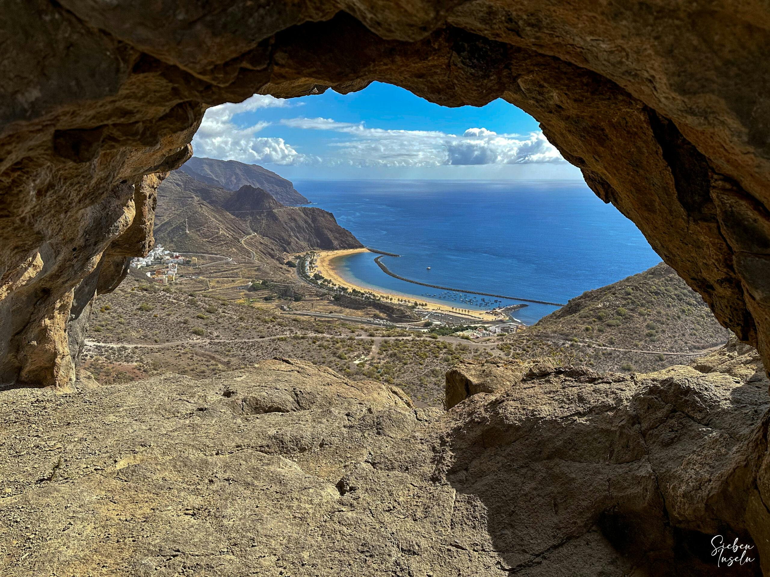
After visiting the San Andrés bunker, you can hike up a little further to reach the so-called Cuevas de San Andrés. There is a fantastic rock gate that you can already see from a distance. If you like, you can take the second detour to the left here and scramble a little to get into the gate. The ascent is rewarded with further very good views, after which you hike further uphill and cross a ridge.
On the hiking trail between the rock gate and the plateau
On the back of the ridge, you descend to a plateau. This is where you part ways. If you like, you can return along the same path. But if you are sure-footed and not afraid of heights, you can also return to San Andrés on a very narrow, steep path. I describe this path here. And if you want more, you can also climb further up and then descend via Valle Brosque and return.
Track of the circular hike above San Andrés with detours to the bunker and the rock gate of San Andrés (Cuevas de San Andrés)
General information on the San Andrés circular hike
Starting point and route
You start your hike in San André on Calle Cercado San Andrés. Hopefully you will find a parking space at the side of the road. If not, you will have to park a little further down the village or further up the Pista Militar.
Calle Cercado San Andrés (left) and Pista Militar (right)
Directions by car
From Santa Cruz de Tenerife, take the TF-11 to San Andrés. At San Andrés, turn into the town onto the TF-12 towards the Anaga Mountains. Before the TF-12 crosses a bridge, turn left towards San Andrés. From this road, turn left again uphill onto Calle Cercado San Andrés. You should already be on the lookout for a parking space, as they are hard to find further up.
Directions by bus
Article summary and large selection of GPS hiking tracks
Sign up for my newsletter now and get exclusive access to my collected GPS tracks as well as all the brief information about my articles.
The Titsa bus line 910 stops at San Andrés. For more information and exact departure times, check the TITSA homepage.
Time
I don’t like to give general times, as the pace and other requirements of a hike are different for all hikers. We needed just under three hours for this short round with extensive visits to the bunker and the rock gate as well as a rest.
Altitude profile of the small round hike over San Andrés
Altitude difference and route length
The route is between 6 and 7 kilometres long and there are a total of 312 metres in altitude to climb.
Requirements
In terms of length and difference in altitude, this hike can be classified as easy. However, if you descend on the narrow path, the hike is more difficult. Hence the general assessment as difficult. The descent requires surefootedness and a head for heights. The same applies to the visit to the rock gate.
To visit the bunker, you should have a torch or headlamp with you.
Refreshments
There are no refreshment stops along the route. You would have to go to San Andrés before or after the hike.
Variants
You can do the small round tour as described here. If you want to avoid the difficult descent, you can also return along the same route. The route would then be 1-2 kilometres longer. If the tour is too short for you, you can also climb further up and then descend via Valle Brosque (difficult) and then return either on foot or by bus.
View from the heights of San Andrés, the Atlantic Ocean and the Anaga Mountains in the background
Circular hike San Andrés
Section Calle Cercado San Andrés to Bunker San Andrés
You start your hike on Calle Cercado. At the first switchback to the left, the Pista Militar San Andrés begins. Follow this uphill for a while. After a short while, a wide road branches off to the right. Follow this uphill over two very long, extended serpentines. At the top of the ridge, the main path continues uphill to the right. However, you go around to the left.
Hiker in the bunker corridors
On a wide path with good views of the coast and Santa Cruz de Tenerife, you continue straight ahead along the right side of the slope. At the end of the path you will come to the entrance to the bunker. With a lamp you can enter the graffiti-covered corridors and finally climb up to the 3rd floor of the bunker on an iron ladder. From up there, you can enjoy wonderful views of the coast through the embrasures.
Article summary and large selection of GPS hiking tracks
Sign up for my newsletter now and get exclusive access to my collected GPS tracks as well as all the brief information about my articles.
Hiker on the stairs to the upper floor in the bunker
Bunker to Cuevas de Andrés (Rock Gate) section
When you have seen everything, go back to the main path along the same route. Up to the left, the wide road continues towards Cuevas de San Andrés. You can already see the large rock gate from a distance. When you reach the rock gate, the path continues straight ahead. To visit the gate, keep to the left. You can climb around the caves and the gate.
On the way to the rock gate via Santa Cruz de Tenerife
If you want to enter the gate, you have to follow a small path that leads you around the rock mass on the left. Then turn right and scramble a little over large rocks up to the rock gate. The view in all directions is worth the small effort. Up here, of course, is also an ideal place for a short rest. Afterwards, walk a short distance back to the hiking trail.
Hiker on the rock gate
Rock gate to plateau section
The hiking trail now leads you further uphill on the right side of the slope. In a small serpentine you reach the ridge. Cross it and continue on the left side of the slope. There you first go downhill a little and then uphill again for a longer time. At the end of the ridge, you will find yourself on a small ridge with wonderful views in all directions.
Hiking trail behind the rock gate along the slope to the plateau
You hike around the edge and now walk downhill along the right side of the slope for quite a while. The path ends on a plateau. Here the path forks. On the left, the path goes steeply uphill towards Anaga. For a longer tour, you can choose this path and then descend via Valle Brosque (not easy) and possibly take the bus back from there. If you are not sure-footed and have no fear of heights, it is best to return from here the same way you came.
Descent path from the plateau
Plateau to San Andrés section
But the shortest route leads around to the right down to San Andrés. Here, however, surefootedness and a head for heights are required because of the narrow path directly on the precipice. Especially the first part of the path is quite a challenge. Once you have done this, the path on the left slope of the mountain runs through bushes and is a little confusing in places, but overall it is manageable.
Hikers on the descent towards San Andrés
You then descend to a ridge. Cross the ridge and walk down to the next ridge. There is an old car wreck (as of October 2023). Descend in a wide serpentine from here. You cross a small barranco and then continue down the slope on a better path. After another switchback, you will see the first houses of San Andrés in front of you. You will reach the street Carrer las Barranquera. Continue straight ahead along this road until you reach your starting point.
View of Santa Cruz de Tenerife from the heights
And finally
I hope you have enjoyed this small but nice loop around San Andrés. Enjoy the variety and the wonderful views. I hope you enjoy your hike,
Dagmar from SiebenInseln
Thank you for reading!
If you've found my hiking guides on SiebenInseln helpful for your Canary Islands adventures, please consider leaving a small tip. Your support is greatly appreciated and helps cover the costs of maintaining this blog.