Small panoramic circular hike high above the caldera
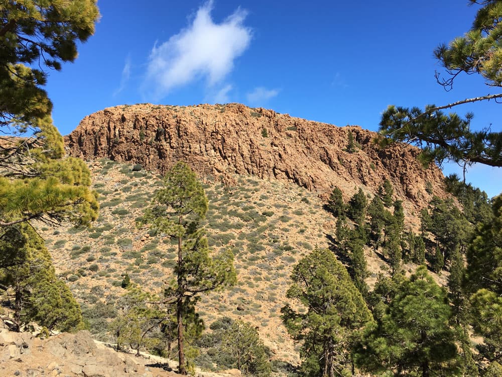
Today I would like to take you on a small circular hike in the southern Teide region of Tenerife. The first destination is an extremely striking rock peak. But actually the summit of Sombrero de Chasna (2.405 meters altitude difference) is rather a big rock plateau. To get up there, you have to scramble a little. But from up there there are wonderful views in all directions.
Map

Hikers on the way to the sobrero de chasna on the circular hike
Then the circular hike – if you want to see more – takes you further in the direction of Cañadas. The trail runs directly over the heights of the mountains that frame the caldera. You will stand very close to the abyss and be able to see the Teide and the wide plains of the Caldera. Fantastic views are therefore guaranteed on this circular hike.
General information about the circular hike

Track of the circular hike to the Sombrero de Chasna
Starting point and approach
Small parking lot approx. 8.5 kilometres above the village of Vilaflor at TF 21 at kilometre 59.7 (2040 metres above sea level). There is also a hiking board at ruined houses.
Arrival by car
normally there is always room for some cars at the starting point. Anyway, so far I have always found a place there easily. Since no bus stops here and a footpath is still necessary with a bus approach, the approach with the car is to be advised.
Approach with the bus
From Los Christianos there are different bus connections to Vilaflor, which vary however between 45 minutes and scarcely 2 hours. The bus lines Titsa number 342 and 482 take less than an hour to get there. The bus lines Titsa number 474, 411, 416 and 450 take almost 2 hours to get there. There are also 8.5 kilometres to walk from Vilaflor to the parking lot on the country road.
Only the bus line Titsa number 342 goes up to the Cañadas. It also goes past the starting point. The bus stops at the Las Lajas picnic area, a good kilometre above the starting point. If you want to travel by bus, you should definitely choose this option. For more information have a look at Titsa Homepage. 
track circular hike Sombrero de Chasna from the distance with surroundings - Vilaflor and the caldera
Time
I do not like to give general time information for hiking tours, as the times are very individual. Hiking should bring recreation and be fun. And also I need for each tour sometimes more and sometimes a little less time. Here the personal rest and break times are not yet considered. But in the average you should calculate about 3.5 hours.
Difference in altitude and distance circular hike
The difference in altitude of the circular hike is about 500 meters and a bit more gross. The route is about 7.5 kilometres long.
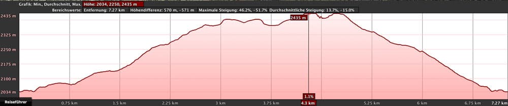
Elevation profile circular hike Sombrero de Chasna
Requirement
An easy tour that can be easily mastered by anyone with a little physical condition. If you are very sporty, you can complete it in less than three hours. And if you want to enjoy the beautiful views, you can take your time. The paths are wide and mostly well signposted. Only in some places at the beginning and shortly before the rock plateau of the Sombreros de Chasna, the path of the circular hike is a little unclear. But you can’t get lost, because the striking rock plateau is always in sight. And to get to the plateau of Sombreros de Chasna, you have to climb a bit in the last few meters.
Refreshment
Restaurants, bars and shops are only available in Vilaflor (8.5 kilometres from the starting point). Therefore, take enough water and food with you.

View over the edge of the Cañadas to the Guajara
Article summary and large selection of GPS hiking tracks
Sign up for my newsletter now and get exclusive access to my collected GPS tracks as well as all the brief information about my articles.
Sign up nowVariants to the circular hike
This tour can be combined well with various other hiking and circular walks in the vicinity. To mention are the famous Paisaje Lunar, about which I will write separately. The hike over the Ucanca Pass down into the Caldera to the Parador Nacional. The hiking trail number 31 starts from this circular hike at the edge of the Cañadas. It always leads along the edge high above the Caldera up to the Ucanca Pass. From there you can descend to the Parador Nacional. This section is part of the hike to the Guajara, that is described here. As it is a circular hike, the tour can of course also be done in the other direction. What is also possible, even happened to me once by mistake, to go up on the descent path described here, then to visit the Sombrero de Chasna and go down on the ascent path described here (like an 8 – thus two round paths 🙂 . There are therefore enough variants for this round tour.
And if the tour is still too long for you, you can only climb the Sombrero de Chasna and perhaps visit the edge of the Cañadas another time. Also the route alone on the Sombrero de Chasna can be arranged as a small circular hike with exceptions of the last and first part of the way.

View to the Sombrero de Chasna from the hiking path on the edge of the cañadas
Circular hike Sombrero de Chasna and edge of the Cañadas
Section Starting point Parking until Barranco de la Magdalena
Right at the car park at 2,040 metres above sea level next to the hiking board, there is a small path, which you can’t miss, that climbs up below the one stone house. With this path you always walk uphill through the pine forest. First you walk parallel over the road. After a short time the path turns into long serpentines. And after a few minutes you reach the first fork. Here the circular path, marked with white arrows, continues uphill on the left. At this point you will come back later. But first you continue straight ahead.
Hiking over rocks and through pine forrests
The path forks several times, keeping to the left. With the path it goes over a ridge and then after a short time on a slope left around to the east. The path continues steadily uphill. You are already approaching the Barranco de la Magdalena. Here you follow the path that leads you uphill in the middle of the Barranco.
Section Barranco de la Magdalena up to a prominent boulder
After some time you can already see the steep wall of the Sombreros de Chasna from your hiking trail through the Barranco de la Magdalena on the right in front of you. Follow the path further uphill and after a while you’ll come to a fork that can’t be missed.

Hiking path beneath Sombrero de Chasna - suddenly clouds are coming in
To the left you would go back later on the circular path, if you choose the variant without a visit „edge of the Cañadas“. But now it goes straight on through the Barranco uphill. From time to time you have to look for the way. It goes uphill in small serpentines. After some time the way leads past a quite large prominent rock. The path runs underneath the boulder and then leads left past it further up the valley.
Section from the prominent boulder to the saddle next to the Sombrero de Chasna.
From time to time clouds can also appear at this altitude, which can take your view – hopefully only for a short time. Even though I got into thick clouds a few times up there, I was always lucky and could enjoy a beautiful view again a short time later. But not only clouds could cloud the wandering luck. Also the way itself is a little confusing here in some places.

Hiking path to the Sombrero de Chasna
Often I have observed hikers, who climbed too far left and right of the way over rocks and searched desperately the way. Once I got caught myself. But since you know the direction uphill, you will sooner or later meet the path that runs through the middle of the Barranco again. When you are on the saddle next to the Sombrero de Chasna, the path forks. You continue straight ahead.
Sombrero de Chasna section
Continue straight ahead to the left of Sombrero de Chasna for a short distance. Then the path to the right leads you to some rock steps. There you have to climb a bit. The path leads over the rock steps directly to the plateau of Sombreros de Chasna. Up here you really have a plateau where you can walk in all directions. Since there is no summit as such, it is really worth walking along the edges of the plateau.

View from the plateau of Sombrero de Chasna direction Teide
At the southern edge you can enjoy magnificent views of the south coast. If the view is appropriate, La Gomera and Gran Canaria are in front of you on the horizon. On particularly clear days you can even discover the distant island of El Hierro. The place Vilaflor is now far below you. In the opposite direction you can see the mighty Teide above the plateau. Up here is also a good place for a rest. Back it goes then over the rocky entrance, on which you also came.

circular hike - path to towards the Sombrero de Chasna
Variation: section Sombrero de Chasna – stone wall
First you go back the short stretch from the Sombrero de Chasna to the fork. If you have had enough, you can take the short circular walk and turn left. This path first leads you down through the upper part of the Barranco de la Magdalena. This is the same path you came. Back to the conspicuous fork in the Barranco de la Magdalena described above. Here you keep to the right and don’t go straight. The latter is the way you came.
Article summary and large selection of GPS hiking tracks
Sign up for my newsletter now and get exclusive access to my collected GPS tracks as well as all the brief information about my articles.
Sign up nowAfter a short while you will come to the signposted path number 31, which leads up to the edge of the Cañadas. If you do the big circular path, you will come back exactly here. But you don’t follow trail 31 uphill, but in the opposite direction. After about 50 metres the trail continues to Las Lajas. But you keep to the left on another path. After a short time this will lead you past a small stone wall.

Hiking group descending the Sombrero de Chasna
Variant Route section Steinmauer – starting point parking lot
Over a mountain ridge it goes now on a path in serpentines downhill. The long hairpin bends lead you slowly through the pine forest. There, where the pine forest has been cleared, there is still the possibility to enjoy the last wonderful views of the south coast of Tenerife through the pine trees from time to time.
While you continue along the ridge, the Barranco de la Magdalena runs below to your left. When you are almost back at the starting point after your descent, you will come to the ascent path. This will bring you back to the parking lot after a short time.

plateau Sombrero de Chasna surrounded by clouds
Route section Sombrero de Chasna – edge of the Cañadas
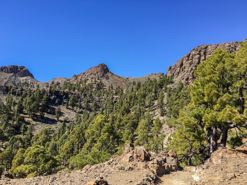
But those who still have some time and fitness should not miss to have a look over the edge of the Cañadas after the visit of the Sombreros de Chasna. Once at this altitude, there are only a few meters to enjoy this fantastic view. If you go from the Sombrero de Chasna (4.005 height meters) to the fork (2.373 height meters), you go straight on a well recognizable path up to the edge of the Cañadas. After about 60 metres you have already made it and from a height of 2,433 metres you can see the Teide, the Caldera and the surrounding mountains. The Parador Nacional is located very small in front of you in the caldera.

circular hike - Panorama with Teide and Cañadas
To the left the path leads you very close to the edge of the Cañadas. One magnificent vantage point follows the next. If you look closely at my track, you will see that I have walked back and forth three times on this section myself. I couldn’t tear myself away from the wonderful views. And of course this place is also suitable for a rest or a picnic.

Panorama view - plateau with Teide in view
Route section edge of the Cañadas and variant hiking trail 31 to Parador
If you haven’t seen enough and would like to continue, the hiking trail number 31 is a good choice. It leads eastwards along the edge of the Cañadas. With this option you follow the path to the Ucanca Pass. From there you can descend to the Parador Nacional. Otherwise, take path 31 in the opposite direction, well signposted, downhill to the left. This path runs directly along or just behind the edge of the Cañadas.
In the valley you can see the path you came on. You go downhill in small steep serpentines and follow the path, which then leads you westwards downhill. You circle around a small mountain at its foot. Then you gradually leave the white rock of the back edge of the Cañadas.

Hikers on the Cañadas high above the Caldera
Cañadas section to starting point Parking lot
At first you continue on the back of a hill on the hiking trail number 31. This trail leads you straight ahead. It always goes slightly downhill. Gradually you get back into the pine-covered area. The path gradually turns into serpentines in the pine forest. You go downhill on a ridge. After some time the path forks. You keep to the right. From the left the path comes out of the Barranco de la Magdalena, where you would have come back if you hadn’t walked over the edge of the Cañadas.

hiking path over rocks to the top
From the fork, the path is identical to the one described above for hikers who did not want to go to the edge of the Cañadas. After about 50 metres, follow path 31 and keep left, while path 31 continues to the right. After a very short time you will pass a small stone wall.

Labrador Lasko on the circular hike
end of circular hike – starting point parking lot
Over a mountain ridge it goes now on a path in serpentines further downhill. The long hairpin bends lead you slowly through the pine forest. Where the pine forest has cleared, there is still the last chance to enjoy the wonderful views of the south coast of Tenerife through the pines.
As you continue along the ridge, the Barranco de la Magdalena runs below you to the left. When you are almost back at the starting point after your further descent, you will meet the ascent path. This will bring you back to the parking lot in a short time.

Panorama Teide and Caldera
And finally
I hope you enjoy this little circular walk high up in Tenerife. From the many combination possibilities of this tour, you can put together the ideal hike for you. Have fun with it and of course hiking,
Dagmar von SiebenInseln