Tegueste a traditional Canarian village on the edge of the Anaga mountains
The quiet village of Tegueste is located in the north-east of Tenerife on the edge of the Anaga Mountains. With a little over 11.000 inhabitants Tegueste is one of the small towns on Tenerife where locals and tourists can still see and experience the typical Canarian life.
Map

Starting point: Church square (Plaza San Marcos) in Tegueste
The historic centre of the town was declared a cultural asset in 1986. Around the church square (Plaza de San Marcos) are colourful little houses and in the small bars people still sit in contemplative peace. Hectic still seems to be a foreign word here.

View of Tegueste
The population lives mainly from agriculture. Around Tegueste there are laurel forests mixed with eucalyptus trees, which are not native to Tenerife. There are terrace fields and vegetables as well as fruit growing. From Tegueste start some walks, which lead in different directions into the Anaga mountains. Today’s hike also starts in the middle of the village on the Plaza de San Marcos.

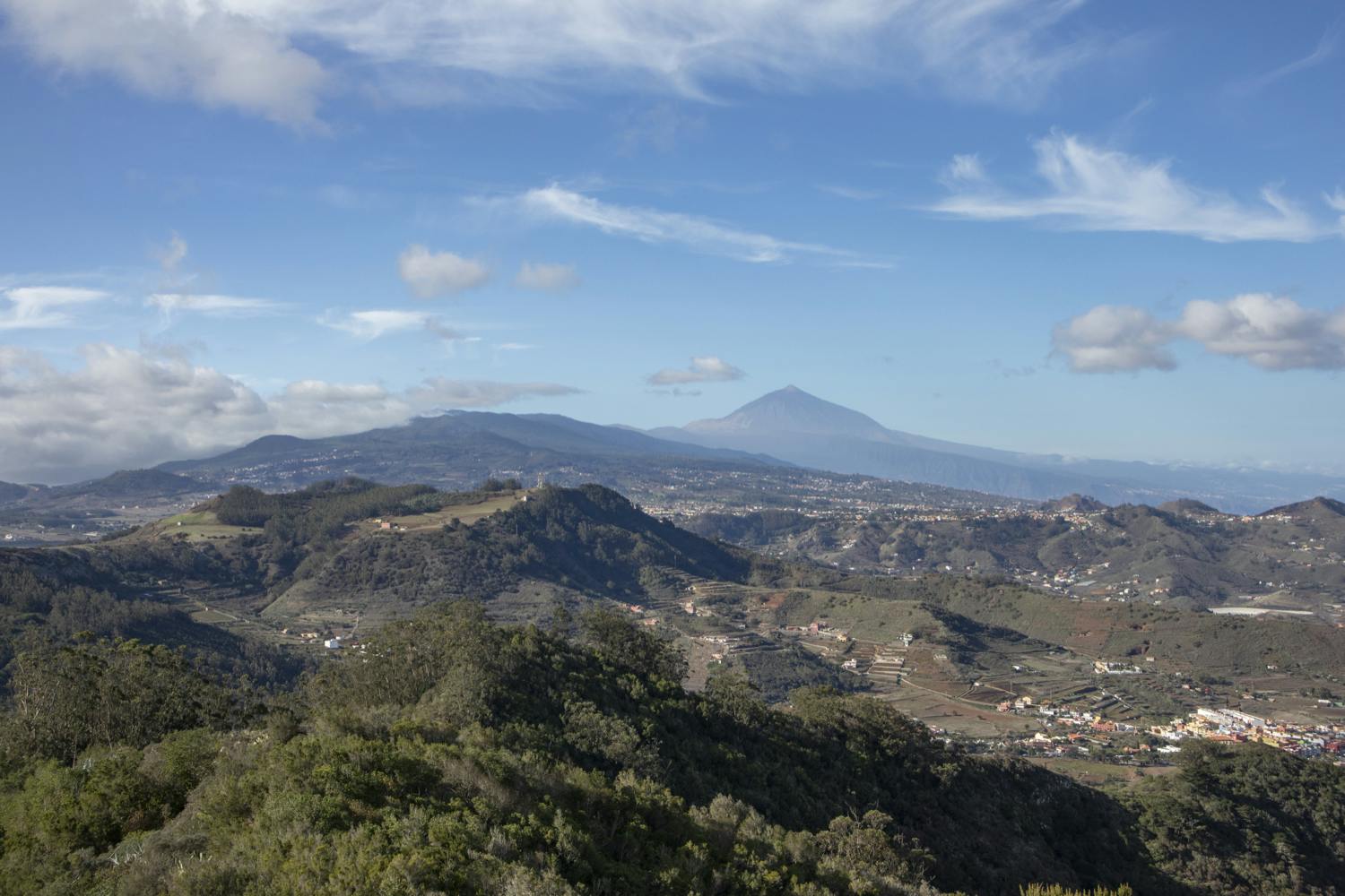
Teide view over Tegueste
From Tegueste over the Valle del Caidero to the Barranco de la Goleta and the Roque Moquinal
The great circular walk starts in Tegueste and takes you upwards through the fields of the Valle del Caidero. Afterwards you ascend in the cloud and laurel forest. When you come out of the forest at the top, you can enjoy magnificent views over the Anaga mountains and to the southwest to the Teide. At altitude, you cross the Barranco de la Goleta and walk along wide forest paths and then downhill on narrow paths that wind their way through the slopes.

View from the forest path to the heights of the Anaga
From the ridge you look down on the heights of the Anaga Nature Reserve and enjoy views of the Atlantic Ocean and the coastal town of Bajamar as you descend. After passing by Roque Moquinal and crossing the Barranco de la Goleta back, the way back is a good climb. From the top you will have a view of Tegueste. On small paths with beautiful views you will finally descend to the village. For all those who find the big round tour with its 14 kilometres too long, there is a small alternative tour from Tegueste to the Mesa de Tejina.
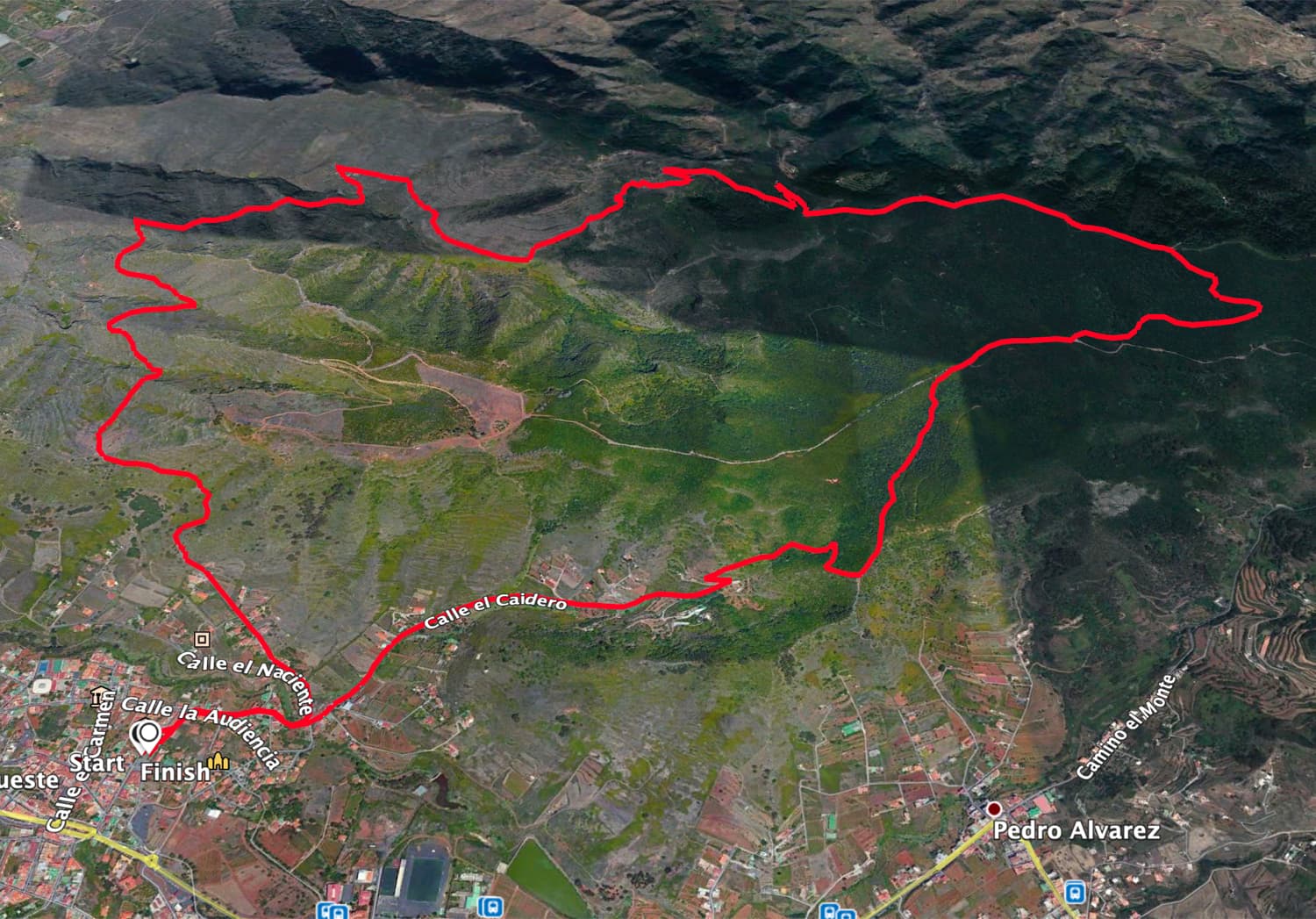
Track round trip Tegueste
General information about the walks around Tegueste
Starting point and approach
You start both hikes (Grand Tour and Tour of the Mesa de Tejina) from the church square (Plaza de San Marcos) in Tegueste.
Arrival by car
You reach Tegueste via the TF-5 and drive via La Laguna or a neighbouring exit towards Tegueste. The historic centre of the town is not to be missed. There are plenty of parking spaces around the church square and on the adjacent streets.
Approach by bus
The Titsa bus lines 050, 051, 052, 105 stop in Tegueste. You can find more information on the Titsa Homepage. Time
I don’t like to give general time indications for hiking tours, because the times are very individual. We needed about 4.5 hours for the big round hike with a rest. The small round tour with a detailed rest at the summit took 2.5 hours.
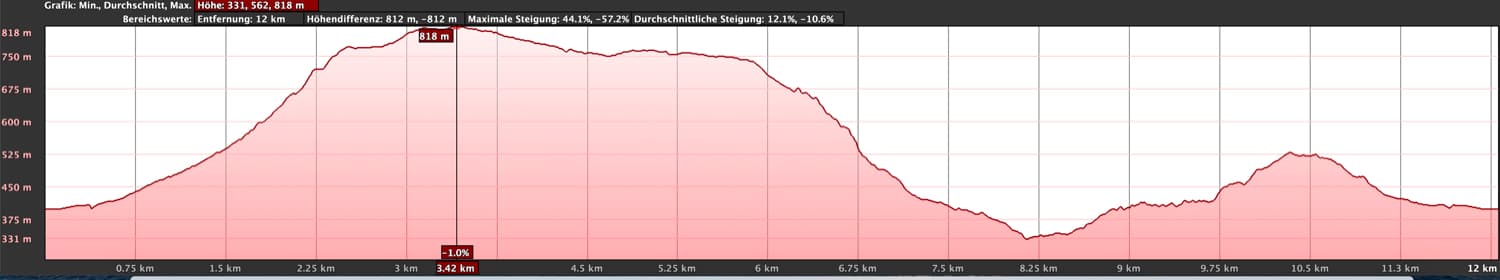
Elevation profile round tour Tegueste
Article summary and large selection of GPS hiking tracks
Sign up for my newsletter now and get exclusive access to my collected GPS tracks as well as all the brief information about my articles.
Sign up nowDifference in altitude and length of the route
The difference in altitude for the long circular hike is about 630 metres. And the route is a little less than 14 kilometres long. The ascent to the Mesa de Tejina of Tegueste requires 350 metres in altitude. And this route is about 5.6 kilometres long.

Elevation profile of the short circular walk on the Mesa de Tejina
Requirement
Both tours are basically easy tours. But because of the gradients and the length of the route on the big circular hike, you should at least be in good physical condition.
Refreshment
Restaurants, bars and shops are only available at the starting point in Tegueste. Therefore, take enough water and, if necessary, food with you.

Track of the small hike on the Mesa de Tejina
Variants
This tour can be easily combined with various other hiking and circular walks in the vicinity. From the tour there are good possibilities to descend to Bajamar or Punta de Hidalgo. If you like, you can also return to Tegueste by bus. You can also extend this tour by visiting the Mesa de Tejina (see small tour) on the way there or back. For those who find the big tour too long, I will describe here the small tour from Tegueste to the Mesa de Tejina. 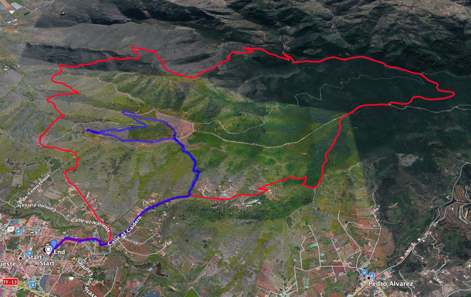
Track round tour Tegueste (red) and track small tour Tegueste (blue)
Great circular walk Tegueste
Section of the church square in Tegueste to the end of Calle de Caidero
You start your walk in the church square of Tegueste (Plaza de San Marcos) and then go right past the church on calle Frederico Fajardo. At the end of the street turn right into Calle de la Audiencia. The path is marked in yellow and white. At the next fork in the road, turn left into calle Puente Palo. Follow this street for a while. It will soon lead you over a beautiful wooden bridge that will take you over a small barranco. You climb up a path and some stairs. At the top, you cross calle Arañita.

on the hiking trail through Tegueste over a bridge (Puente Palo)
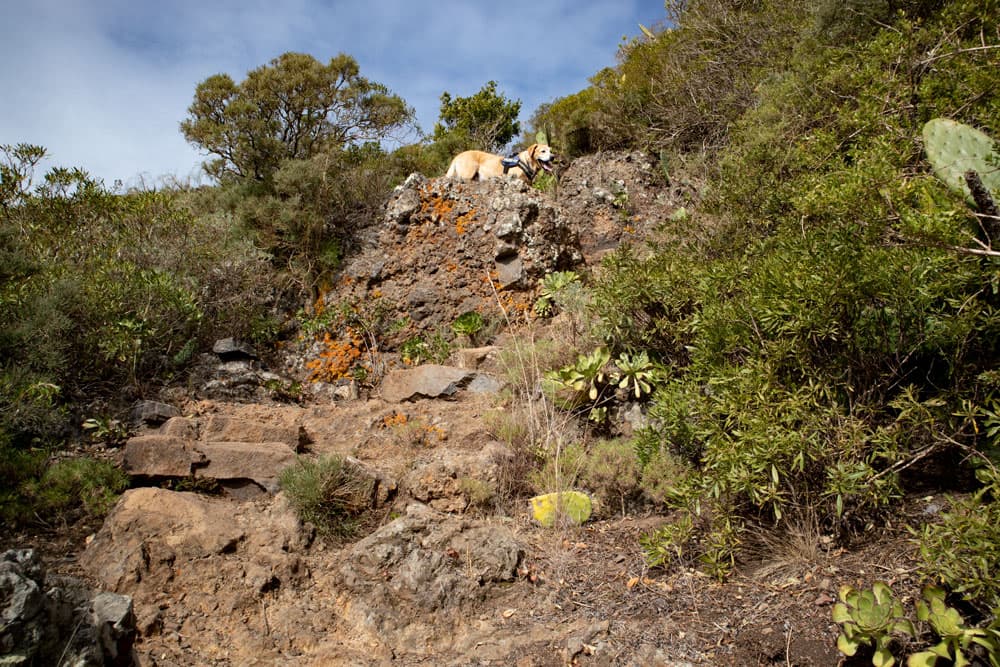
You get to calle de Caidero. Follow this street for a while, passing houses and fields and going slightly uphill. After a while you will see the yellow and white markings with a small steep path to the left of the road. The entrance is equipped with a few steps. Here you can climb up to the Mesa de Tejina. But on the big circular walk we continue to follow the road straight ahead. It takes us past more farmsteads, terraced fields and meadows, and finally ends at the level of the last farm of Tegueste on our left.

Entry hiking trail to the Mesa de Tejina
End of Calle de Caidero up to an altitude of 820 metres
At the end of calle de Caidero, the ascent path begins, which takes you steeply up the valley to the mountain slopes. The scrubland soon turns into a forest of laurel trees. You only climb up on the left side of the slope. Then the path crosses the valley. Then you walk uphill on very steep paths. After the ascent you will reach a ridge. From here you have a wonderful view over Tegueste to the Teide. And on the other side you will see the small village of Pedro Alvarez below you. You could go down there by following the path to the right.

first steep climb over Tegueste
However, for the circular walk you keep to the left. The path will take you along the ridge for a while and continue to climb. In between you can enjoy beautiful views. Then you walk through thick laurel forest again. Finally, you will come to a very wide and well-maintained path, which you follow to the right. To the left it also leads to the Mesa de Tejina. However, if you do not want to see it now or some other time, you can walk a little further to the right. At the next fork, keep left. Now you have reached the highest point of the hike at about 820 metres altitude.

View of the Teide after the first ascent
Route section approx. 820 m altitude difference until the junction with the Barranco de Goleta path
Article summary and large selection of GPS hiking tracks
Sign up for my newsletter now and get exclusive access to my collected GPS tracks as well as all the brief information about my articles.
Sign up nowIn a wide arc over the valley, the path now leads you down through the forest. In some places the forest opens a little. Now you can enjoy views over the heights towards the Anaga Mountains. You always walk along the wide path through the forest. Finally, at a barrier on the left, you will find the path going downhill. With time the path gets narrower and steeper. Then you also get out of the wooded area. You go partly downhill on big serpentines below the Roque Moquinal above the Barranco de la Goleta.

Descent path below the Roque Moquinal
Here at the top you will actually come across some isolated farms and you will also see terraced fields cultivated in the Barranco below you. For quite a while the path goes downhill quite steeply on the slopes. The views of the coast in front of you and later on to the coastal town of Bajamar are impressive. On the left below you is the Barranco de la Goleta. After some time, the route continues downhill along the mountainside towards the coast. If you would follow this path further, you would come to Bajamar. But you turn left at a small dilapidated house and follow the path down into the barranco.

View of Bajamar
Junction of the Barranco de la Goleta path to the church of Tegueste
The small path leads you down into the Barranco and after crossing the Barranco, up again on the other side of the slope. As you continue your ascent, you will cross the foothills of the mountain range where the Mesa de Tejina is located. The path follows the slope directly uphill around the foothills of the massive rocky massif. In front of you, you will see the ridge of the mountain to which you are climbing. The ascent ends on the ridge in a large saddle. From here, you could also continue to climb up to the left towards the Mesa de Tejina.

Hiking trail along the slope
For the circular route, however, keep straight on after enjoying the fantastic views. Now the path leads you on the other side of the mountain, high above Tegueste, gently downhill. Little by little you will get closer to the colourful houses of Tegueste. At Tegueste, the path becomes Calle de Sardán. Follow this street straight ahead for a long time. After a while this becomes Calle de Naciente. Follow this one a little bit as well. Finally, turn right again into Calle Puente Palo. Now you go back to the church square of Tegueste in a short time, following the same way you came.

square surrounded by stones below the Mesa de Tejina
Hike Tegueste to the Mesa de Tejina
Route section Tegueste church square to Mesa de Tejina access path
The first part of the hike is identical to the great circular hike Tegueste. You start your walk at the church square of Tegueste (Plaza de San Marcos) and then go right past the church on Calle Frederico Fajardo. At the end of the street turn right into Calle de la Audiencia. The path is marked in yellow and white. At the next fork in the road, turn left into calle Puente Palo. Follow this street for a while. It will soon lead you over a beautiful wooden bridge that will take you over a small barranco.
Climb from Tegueste to the Mesa de Tejina
You climb up a path and some stairs. At the top, you cross calle Arañita. You get to calle de Caidero. Follow this street for a while, passing houses and fields and going slightly uphill. After a while you will see the yellow and white markings with a small steep path to the left of the road. The entrance is equipped with a few steps. Here you can climb up to the Mesa de Tejina.

View from the Mesa de Tejina to the coast
Mesa de Tejina access path to Tegueste church
There follows a very steep ascent on narrow paths that quickly takes you high above Tegueste. But once you reach the top of the plateau, you can enjoy a wonderful panoramic view over Tegueste to the Teide and on the other side down to Bajamar and Punta Hidalgo. In my track you can see that we just made a round around the plateau and looked at everything from every direction up there. Afterwards we descended again on the same track. 
Blick auf den Teide
But if you like, you can of course continue from up here on the signposted hiking trail down to Bajamar or on the big circular trail around the Mesa de Tejina. Or you can walk back over the ridge to the path that leads you to the forest and then to the big circular path around the Mesa de Tejina. If you want to do some climbing, you can also climb the top of the Mesa de Tejina on the west side on a narrow path. If you don’t want to walk on from here or have seen enough, go back to the church square in Tegueste on the same path you came.

Aufstieg zum Sattel unterhalb der Mesa de Tejina
And finally
I hope you enjoyed these two walks around Tegueste, which can be combined very well. Of course you can walk them in many different ways. If you want to walk all the way down to the coast to Bajamar or Punta Hidalgo, you can also take the bus back to Tegueste. Whatever you decide to do, I wish you lots of fun on all your walks,
Dagmar of Seven Islands