Tijoco is a small mountain village with about 2500 inhabitants, situated about 8 kilometres from Adeje at an average altitude of 1081 metres above sea level. The area around the small municipality is characterised by an extensive rural environment.
Map
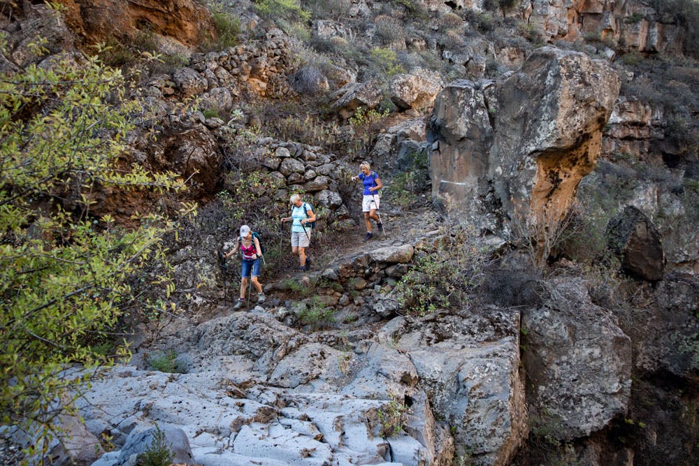
View back to Tijoco and farmhouses
Tijoco is divided into the districts of La Concepción, Tijoco Alto, Tijoco Bajo, La Hoya Grande and Marazul. And between La Concepción and the high Tijoco (Tijoco Alto) starts this beautiful circular walk.
Road behind La Concepción - starting point of the hike
But first a little more to Tijoco. The place has some cultural centers, like a center for infant and primary education, the church of La Milagrosa in Hoya Grande, the church of the Virgen del Carmen in Tijoco Bajo. And of course there are small shops, bars and restaurants as well as a pharmacy and a gas station. Parts of the municipal area belong to the Corona Forestal nature reserve. The landscape around the Barranco de Erques, where I already described a hike, is also protected.
Trees at the roadside on the way to Iserse
Hike around Tijoco Alto
This big round trip, which starts near the village Tijoco Alto, leads you first across the Barranco Ajabo and after some time back again through the huge gorge. From then on, the south-western slopes of Tenerife continue to rise in a varied and often agricultural landscape. On the way you will pass farmed farms as well as empty houses. Through the Barranco de Icerse we continue up towards Risco Tonásaro. Up there at Era los Sorda you will find a very small agricultural settlement with many terraced fields.
Gorges and the Caldera in the background
And there you can also have a look at the huge Barranco de Erques, which you will walk along. Then it goes in a small arc back along the canal until you meet your way there. The hike is in the slimmed down form a big round and in the extended round an eight with another small circle. Back on the original route, the path now leads you on the other side of Barranco through pine forest and dense bushes. You hike high above Tijoco Alto along the canal to the starting point of the hike at La Concepción.
Track of the great variant about Tijoco Alto
General information about the circular hike Tijoco Alto
Starting point and approach
The starting point of this hike is a fork in the road between La Concepción and Tijoco Alto. Just after La Concepción, a small road branches off to the right. The coordinates are: 28.160436, -16.733846. Here you can park well at the roadside.
Starting point of the road junction at La Concepción
Approach by car
Coming from the south or north on the TF-38, turn off at the small town of Menores towards the mountains (Tijoco Alto excellent). Then you drive very long on the serpentines through the individual districts of Tijoco until you finally reach the starting point behind La Concepción.
Arrival by bus
The Titsa bus line 417 goes only to Tijoco Bajo. You can find more information on the Titsa Homepage. If you don’t have a car, you can only take a taxi from there to the starting point.
Time
I don’t like to give general time information for hiking tours, because the times are very individual. We needed 4.5 hours for this tour. For the variant without the extra round „Acht“ 3.5 hours.
Article summary and large selection of GPS hiking tracks
Sign up for my newsletter now and get exclusive access to my collected GPS tracks as well as all the brief information about my articles.
Elevation profile of the large variant Hiking Tijoco Alto
Difference in altitude and distance
The difference in altitude is approx. 680 metres and for the small version approx. 480 metres. The route is 12 kilometres long and the variant just under 9 kilometres.
Elevation profile of the small variant hike Tijoco Alto
Requirement
A medium hike for which you need stamina. From time to time in a few places the route is a bit confusing. But in general you hike on good driving and hiking paths. Through the gorges and in the higher area you sometimes have to walk quite steeply up the mountain.
Refreshment
There are restaurants, bars and shops – as described above – in Tijoco. You will see some of them on the way to the starting point of the hike. But there is no place to stop on the hike. Therefore take enough water and food with you.
Tracks of the three hikes around Tijoco Alto and the Barranco de Erques
Variants
This tour can be combined well with various other hiking and circular walks in the vicinity. On the one hand I describe here already a smaller and a larger round walk to you. Both can also be combined very well with the hike at the Barranco de Erques, which is adjacent to this hike.
rack of the small variant hike Tijoco Alto
I describe the tour here counterclockwise. In fact, I have already walked it the other way around. You can choose the right one for you as well as a suitable variant combination.
View of the coast from the footpath at altitude
Hike Tijoco Alto
Section from the fork between La Concepción and Tijoco Alto to Barranco del Quisio
You keep walking along the little road you park on. It is barely frequented and leads you after a short time into the Barranco Ajabo. You walk down the road, cross the Barranco and then come back to a driveway on the other side of the Barranco. Follow this road uphill for a while. It always runs along the edge of the gorge. Then you get to some houses. In front of them a road branches left down into the Barranco.
Hiking trail road in the Barranco Ajabo
Follow the path and cross Barranco Ajabo a second time. But now on a sandy road and in the other direction. On the other side you first pass a finca. High above you, you already see a big abandoned house lying. This is where you will hike. When you pass the houses on the road, the road turns into a small path that takes you through another Barranco, the Barranco del Quicio.
Hiking trail uphill towards Iserse
Section Barranco del Quicio to Iserse
Once you have climbed out of the Barranco del Quicio on the other side, you continue to climb along the path. Between two gorges, the path climbs up the ridge. Some of it is quite steep and then a bit more moderate uphill again. To your right is the Barranco de Tejera. You hike along it for a while. Then the path turns away from the gorge. Above you you can already see the big abandoned house.
Hike up to the ruin house of Iserse
Article summary and large selection of GPS hiking tracks
Sign up for my newsletter now and get exclusive access to my collected GPS tracks as well as all the brief information about my articles.
You walk past some figs and chestnut trees. The wide path leads up to the house. But after a hairpin bend you can take a shortcut on a narrow path that branches off to the right of the path and walk directly up to the house. Maybe you’d like to take a look around. The big abandoned house is called Iserse. Under the almond trees there is also a nice place for a rest.
the abandoned house of Iserse
Section Iserse to junction Barranquillo de Iserse
On the way you will hike uphill past Haus Iserse. After a short time you will come to a driveway, which you follow to the left. If you now want to go the smaller of the two variants, you have reached the highest point of the hike and follow the road downhill again to the left. At this point, to which we also return after the extra round, there is a large tree under which many chairs stand. Here is a meeting place for hunters. But if you want to do the big round, you have to go uphill on a path that branches off to the right of the road.
Canal in the Barranquillo de Iserse
You walk uphill for a while on the right side of a canal. Then the path branches off to the left across the canal. Later you come back from straight ahead at this point. Now go over the canal and hike over a ridge. Then the path leads you again into a gorge. You walk into the Barranquillo de Iserse, cross it and climb up again on the other side. This section from the canal to here is also part of the walk along the Barranco de Erques. That’s why you have good combination possibilities here again. But while the latter hike continues straight ahead on the hiking path, you now turn right onto a path and continue uphill.
Terrace fields in the height close to the Barranco de Erques
Road junction Barranquillo de Iserse to the junction at the canal
From this turnoff, the trail climbs steeply uphill on a partly very rocky footpath. You can already see the terraced fields and some houses of a small settlement high above you. There you hike up – at the end on a very steep road. When you reach the top, the road will take you past various houses and farmsteads. You cross a mini gorge with terraces. Finally you reach the edge of the great Barranco de Erques. Here you can enjoy fantastic views into the gorge and down to the coast.
Barranco de Erques with cave houses
On the road you walk a short time to the right at the edge of the Barranco further slightly uphill. Then the road branches off to the right. You reach another road, which you now walk down to the right. The highest point of the hike is reached at the junction. The road then takes you slowly downhill in a few large arcs around several gorges. At some point you will meet the canal again, which runs down the hill on the right coming from the left. On the right side is a small path. Here you branch off the road and always follow the path along the canal.
Junction canal path
Route section junction at canal to abandoned house
Partly the path is a little overgrown and runs through bushes and small pine forests. Finally you reach the spot where you crossed the canal on your way there. Now the upper small circle is finished. Continue down the canal until a short time later you come to the place with the big tree under the chairs. Here in the shade is an ideal resting place. Now you are back on the starting circle. All those who left out the extra circle will now continue from here.
Hiking trail through the pine forest
First you follow the road. After a short time a path branches off to the right through the forest. Follow it. In a pretty arc with good views of the coast and the Teno mountains, a well laid out hiking trail takes you to another small abandoned house. Behind the house the trail goes along and then down again in the forest. If you look at my different tracks, you will see that you now have different possibilities. You can also descend in a large curve on the road in front of the house. Or you can go down across small forest paths and through some rough terrain (like on this track).
Hiking trail along the canal - Tijoco Alto
Section of deserted house to starting point of the hike (junction road)
Whichever descent you choose from the abandoned house, you will eventually find yourself further down on a path that will take you, after some time, to a larger downhill path along the canal. Without all the detours you could have walked further from above directly along the canal. But then you would have missed the abandoned house. Along the canal the path takes you further down with wonderful views.
View of the coast
To your right you can see Tijoco Alto below. In front of you is the district of La Concepción, which is getting closer and closer. Finally, the path ends on the road. Now it is only a few meters to the left along the road. And then you stand at the junction, the starting point of your hike.
Hiking trail high above Tijoco
And finally
I hope that you enjoyed this rather large circular walk, which you can go in many variations. I wish you much joy on all your hikes,
Dagmar von SiebenInseln
Thank you for reading!
If you've found my hiking guides on SiebenInseln helpful for your Canary Islands adventures, please consider leaving a small tip. Your support is greatly appreciated and helps cover the costs of maintaining this blog.
Thank you for your support!
SSL secured
Comments
Volodymyr - 11/23/23, 06:21 PM
Did today small circle. Just wanted to notice that there are many new signs „coto privado de caza“ which means private hunting area on the trail.
I didn’t meet anyone on my way, but be careful.
Many of them are in this area 28.1644639,-16.7251805