Cruz Grande and the small town of San Bartolomé de Tirajana
The Cruz Grande is a pass located at 1249 metres above sea level. The saddle is also called Degollada de la Cruz Grande. From up there, you can enjoy views of two different valleys. On one side you can see the Caldera de Tirajana and on the other the basin of Chira. At Cruz Grande, many old paths meet, such as the Ruta de la Plata, which is also part of the Way of Saint James in Gran Canaria. During your hike you will also come to Cruz Grande. From there you descend on the Camino Real to San Bartolomé.
Map
View and information board Cruz Grande
San Bartolomé de Tirajana lies below the Cruz Grande and is the starting point of this hike. The municipality has about 55,000 inhabitants. The addition in the name Tirajana refers, as in Santa Lucia de Tirajana, to an ancient Canarian tribe that lived in this area before the Spanish conquest. Today, the municipality, which is still referred to by its old Canarian name „Tunte“, comprises more than 30 different districts. Before or after the hike, you should definitely take the time to visit the picturesque alleys of the small town.
View of San Bartolomé from the hiking trail
Hiking from San Bartolomé de Tirajana over the Cruz Grande
This beautiful circular hike really offers you a lot of variety. It runs along good hiking trails and offers beautiful views. With an altitude difference of just under 500 metres and a length of just over 12 kilometres, it is also easy for hikers to manage. Right at the beginning of the hike in San Bartolomé de Tirajana, you can experience the small town and enjoy wonderful views over the Caldera de Tirajana and to the Cumbre.
Then you hike up to the Degollada de la Manzanilla. And from there you continue around the rocky massif through the pine forest. A small highlight of the hike is the Cruz Grande. From there you can enjoy the panoramic view. Afterwards, you walk back down to San Bartolomé de Tirajana on a cobblestone path, the Camino Real S-50.
San Bartolomé - Cruz Grande Hike Track
General information about the San Bartolomé de Tirajana and Cruz Grande hike
Starting point and approach
Starting point of the hike is San Bartolomé de Tirajana village centre near the church on GC-60.
Arrival by car
You come to San Bartolomé de Tirajana on the GC-60 or GC-65, depending on the direction. Drive through the town on the GC-60. There is a large car park just behind the church where you can park. Otherwise, you will also find some parking spaces in the town along the streets.
Arrival by bus
Bus line 18 stops at the starting point of the hike in San Bartolomé de Tirajan as well as directly at Cruz Grande. You can find more information on the Guaguaglobal homepage.
Time
Article summary and large selection of GPS hiking tracks
Sign up for my newsletter now and get exclusive access to my collected GPS tracks as well as all the brief information about my articles.
I don’t like to give general times for hiking tours, as the times are very individual. I needed just over 4 hours for the entire route with a few breaks
Altitude profile of the San Bartolomé - Cruz Grande hike
Altitude difference and route length
The difference in altitude is about 500 metres (with the small detour to a viewing hill) and the route is about 12.5 kilometres long.
Requirement
On the entire loop you walk on good and often cobblestone paths.
Refreshment stops
Bars, restaurants and cafés can be found at the starting point San Bartolomé de Tirajana. Nevertheless, please take enough water and food with you for the hike.
Hiking signs in San Bartolomé - way back S-50 from Cruz Grande
Variants
The hike can be combined with many smaller and larger hikes around San Bartolomé de Tirajana and the Cruz Grande. You will find good and detailed hiking signs everywhere in the area.
On SiebenInseln I have already presented the hike from Cruz Grande to Pico de las Nieves. Another hike via Cercado de Arañas and the Cruz Grande will be added soon.
If you want to shorten the tour, you can also take the bus for the part between Cruz Grande and San Bartolomé de Tirajana.
View of San Bartolomé and the Cumbre from the hiking trail
Hike San Bartolomé de Tirajana via Cruz Grande
San Bartolomé de Tirajana to the slope Morro de las Vacas
You start your hike in front of the church Iglesia San Bartolomé on the GC-60 at 887 metres altitude. First, walk a short distance along the main road and turn into the next road on the right. Follow the signs for S-57 Degollada Manzanilla uphill on this road. It joins another road, which you follow around to the left. This will take you uphill in a series of hairpin bends in San Bartolomé. After a hairpin bend, turn left into Calle el Roque, signposted Degollada Manzanilla.
Hiking trail behind San Bartolomé
You will return from straight ahead later. Calle el Roque (GC-603), which you follow straight on for a long time, takes you out of the town past the Mirador Las Tirajanas and the football stadium. Then the trail to Degollada Manzanilla turns right. After a short while, it reaches a path that you follow around to the left. You come to a fork in the road. Here you keep to the right. You walk between larger farms and businesses. After a while you will reach the slope of the Morro de las Vacas rock massif.
Article summary and large selection of GPS hiking tracks
Sign up for my newsletter now and get exclusive access to my collected GPS tracks as well as all the brief information about my articles.
View of the Cumbre from the hiking trail on the slope
Section slope Morro de las Vacas to Barranco de Pilancones
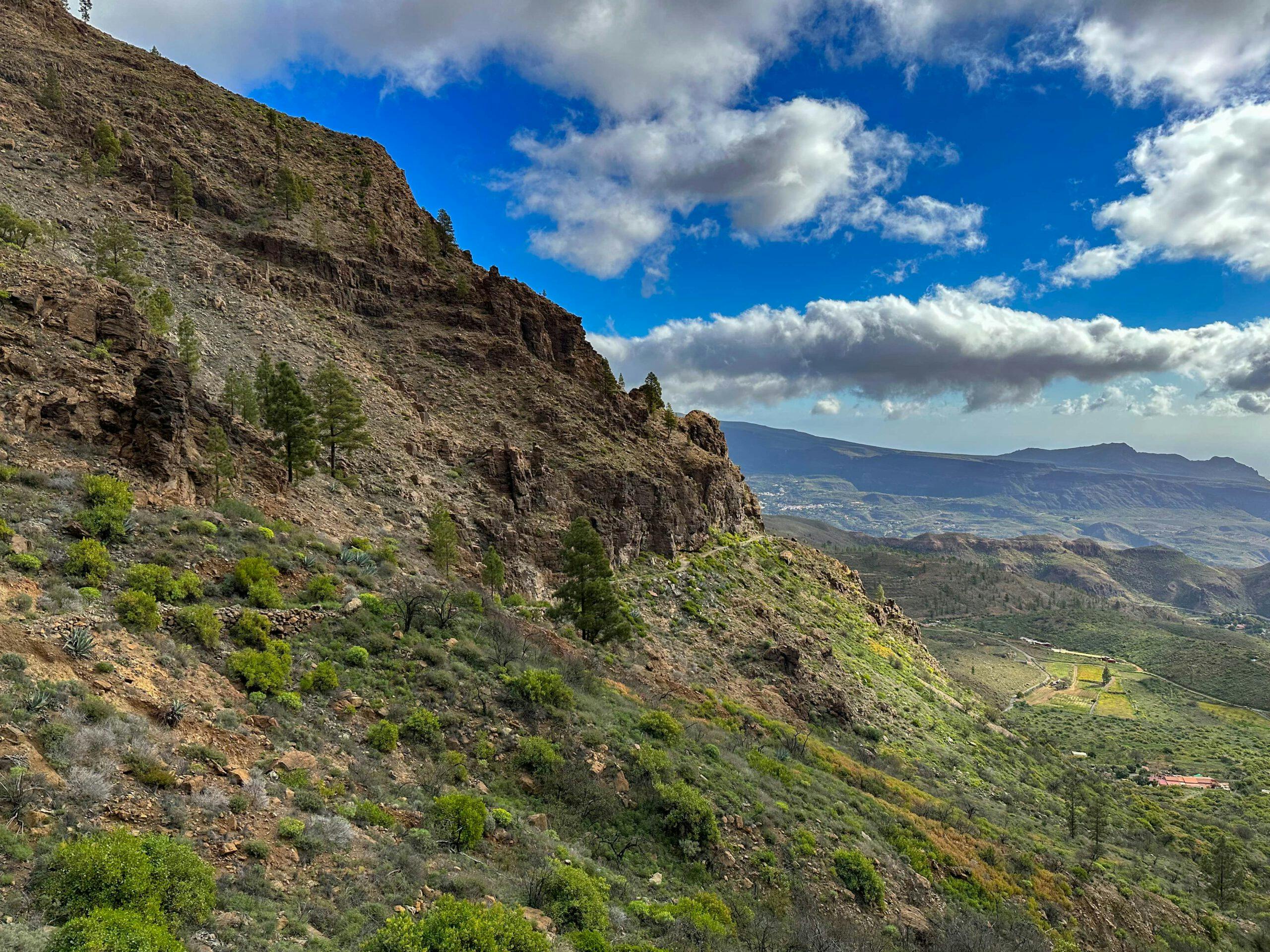
Now the path takes you up the slope for a long time. You cross the Morro de las Vacas rocks on the narrow side. Afterwards, the path winds up for quite a while with the best views to the Degollada de la Manzanilla (1160 metres altitude). At the top of the pass, you can already enjoy views in the other directions. Then follow the track around to the right. This now takes you for a very long time through the pine forest on the other side along the slope of the Morro de las Vacas.
Hiking trail up along the rock massif
An easy, relaxed path on the wide track leads you up and down the mountain for a long time. Finally, the trail turns left with a yellow-marked post. To cross the Barranco de Pilancones, you can leave the track for a while and shorten the crossing a little on a hiking trail. On the other side, you will eventually rejoin the track, which you follow around to the left.
View from the Degollada de Manzanilla back to the hiking trail
Barranco de Pilancones to Cruz Grande section
On the forest road, you now circle the Morro de Guanil. Here, too, you continue along the slope. Once again, you will go around a small ravine, cross the ridge and continue along the slope. At a fork, where a path branches off to the left down to Soria Lake, keep to the right. After a short while, you can walk a few metres to the left of the track to the Degollada del Dinero.
Hikers on the trail below the Morro de las Vacas on the trail through the Barranco de Pilancones
This is an ideal spot with good views for a short rest. Then continue on the track towards Cruz Grande. The path takes you along the buildings of the Gran Canaria Environment Agency. Finally, it joins the GC-60 at Cruz Grande, where you can once again enjoy views in all directions. Turn right on the Cruz Grande pass to reach the other side, from where you descend.
Small detour to the Degollada del Dinero with a good panoramic view shortly before Cruz Grande
Cruz Grande section to San Bartolomé church starting point
At Cruz Grande, a dirt road and then a well-paved Camino Real (Camino de Santiago) will take you down towards San Bartolomé. You walk downhill through the pine forest on the slope of the Morro de la Cruz Grande with beautiful views of the Cumbre and the wide valley in front of you. At the end, the trail joins a dirt road that you follow around to the left.
Hiking trail Cruz Grande
This track ends on a path, which you follow around to the left. Cross the GC-603 and continue along Calle Escaleritas until you reach the next junction on the right. This will take you down to where you turned into Calle el Roque on your way out. From here, return to the town along the same route as the outward one.
Well paved and serpentine hiking trail S-50 Cruz Grande - San Bartolomé
And finally
I hope you enjoyed this short hike from San Bartolomé over the Cruz Grande. It should be doable for every hiker because of the good paths and moderate ascents. I wish you lots of fun on all your hikes,
Dagmar from Siebeninseln
Thank you for reading!
If you've found my hiking guides on SiebenInseln helpful for your Canary Islands adventures, please consider leaving a small tip. Your support is greatly appreciated and helps cover the costs of maintaining this blog.