Pico de Las Nieves – the second highest peak on Gran Canaria
The Pico de Las Nieves is the second highest peak on Gran Canaria after the Roque Nublo with its 1949 metres. If the weather is good and the Cumbre is not surrounded by clouds, you can enjoy wonderful views over the mountain ranges of Gran Canaria all the way to Tenerife on the entire hike.
Map
In winter, Pico de Las Nieves is sometimes covered in snow. Hence the name. But one thing in advance. You can also drive up Pico de Las Nieves on a road. So don’t be disappointed if you have to hike up the mountain and come across a food truck and a lot of tourists with their vehicles.
Ascent paths in front of the enormous rocks of the Cumbre
The way to Pico de Las Nieves
But the attraction of this hike does not lie exclusively in climbing Pico de Las Nieves. The hike across the Cumbre with its magnificent views is particularly impressive. A special extra is the short excursion from the main trail to the Ventana del Nublo. You can climb up to this impressive rock arch and look out over the countryside.
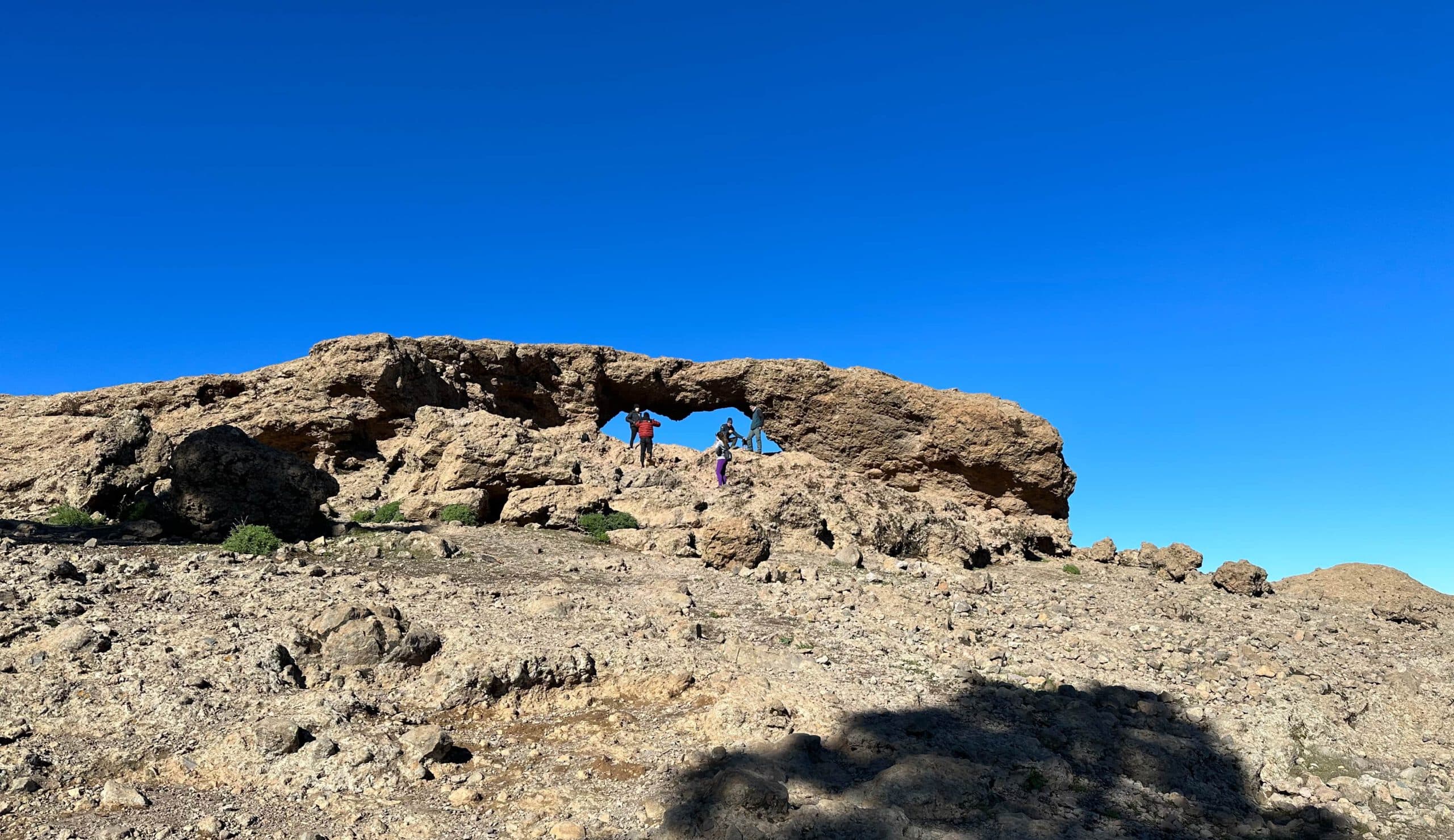
Rock gate with a view as far as Tenerife - Ventana del Nublo
Through the window you will see Roque Nublo, from which the rock arch takes its name, as well as the neighbouring island of Tenerife. All in all, it is a somewhat strenuous hike, especially on the ascent. But at the top of the Cumbre, you will know that the effort of the climb was worth it. You will also find not only hikers, but also many runners and even some mountain bikers up there.
Track of the hike Cruz Grande - Pico de las Nieves
General information about the Cruz Grande to Pico de Las Nieves hike
Starting point and approach
The starting point of the hike is the Cruz Grande pass (1249 metres altitude) on GC-60.
Car park at Cruz Grande with hiking signs
Arrival with car
You can get to Cruz Grande on GC-60 from both the west and the east. There are a few parking spaces directly on the pass, but they are usually occupied at late hours. Then you have to drive down the road a bit and park on the side of the road.
Arrival with bus
Bus number 18 stops directly at Cruz Grande. More information can be found on the Guaguaglobal homepage.
Article summary and large selection of GPS hiking tracks
Sign up for my newsletter now and get exclusive access to my collected GPS tracks as well as all the brief information about my articles.
II don’t like to give general times for hiking tours, because the times are very individual. I needed 5.5 hours for the entire route with a few breaks and the detour to Ventana del Nublo.
Elevation profile of the Cruz Grande - Pico de las Nieves hike
Altitude difference and route length
The difference in altitude is about 820 metres and the route is about 16 kilometres long.
Requirements
On the entire loop you walk on good and often cobblestone paths. However, a very good level of fitness is a prerequisite due to the length of the route and the metres in altitude and sometimes steep ascents.
Refreshment stops
You will usually find an open food truck on the Pico de Las Nieves viewing platform. Nevertheless, please take enough water and, if necessary, food with you for the hike.
Variants
The hike can be extended as much as you like. If you don’t just want to walk this route back and forth, you can also walk further along the Cumbre. Then you will get to the Caldera de Los Marteles, for example, which I have described here. Continuing on, you will come to the lower Cumbre, which I described in the article Great Hiking Tour over Cruz del Siglo and the Cumbre. Of course, you can also hike up the entire Cumbre from Santa Lucia and then take the bus back from Cruz Grande. You can decide how far you want to hike and what you can do fitness-wise.
Variant Track: Small round trip from Llanos de la Pez to Pico de las Nieves (green)
Variant altitude profile: Small round trip from Llanos de la Pez to Pico de las Nieves (green)
If this route to Pico de Las Nieves is too strenuous for you, there is an easier alternative. You start the hike at the Llanos de la Pez rest area on the GC-600. From there, there is a beautiful circular trail to Pico de Las Nieves with a length of just over 3 kilometres and only about 330 metres of ascent. The path leads you mostly through the forest and is well signposted. I walked it once a few years ago and unfortunately no longer have a track. Therefore, I provide a track downloaded from Wiciloc in the download area, which goes to just below the Mirador Pico de Las Nieves, so that you will easily find the viewing platform.
View down from the Cumbre to the Cruz Grande
Hike Cruz Grande to Pico de Las Nieves
Cruz Grande section to the Llanos de Pargana ascent trail
You start your hike at the Cruz Grand on the GC-60. From there you go down the road on the right for about 50 metres towards San Bartolomé. On the left of the road, the Camino Real PR GC 40 (also Camino Santiago de Gran Canaria) begins, which leads you up a small road to the ridge above the Cruz Grande. There you will pass a few crosses and a house. This is where the cobblestone path begins, which takes you uphill first on the right side of the slope and then directly on the ridge.
Hiking trail on the ridge to the cross walk on the slope
Article summary and large selection of GPS hiking tracks
Sign up for my newsletter now and get exclusive access to my collected GPS tracks as well as all the brief information about my articles.
From here you can already enjoy beautiful views of the countryside on both sides of the ridge. After a while, the trail turns to the left, so that you walk along the slope high above the La Plata Valley. Impressive rocks in front of and beside you and a wide view of the vast landscape below. Although you have been climbing steadily uphill, the really steep ascent only begins here. After a while, you come to a very well designed serpentine path.
Route section ascent path to Llanos de Pargana to Ventana del Nublo
This very steep and well-designed ascent path is simply impressive. Built into the rock, it spirals steeply upwards. It is often used by mountain runners as a training route. The views are simply fantastic. After the rather hard climb, you reach the barren yellow-reddish plain of Llanos de Pargana. From here you can enjoy the view in peace. Then continue across the plateau on the path marked with cairns. You walk parallel to the edge of the Cumbre. In places, the path runs through a little pine forest.
Mountain bikers on the Llanos de Pargana plateau
Then you have a clear view again. After a while, you will see the deep Barranco de Tirajana on your right. You walk along the slope a little downhill through the pine forest. To the left, you can now take a short detour from the signposted path to the Ventana del Nublo rock gate. After a small climb to the left of the path, you will soon reach this rock window. From there, in good weather, you can see not only the highest point of Gran Canaria, the Roque Nublo, but also the neighbouring island of Tenerife.
Rock Gate with a View - Ventana del Nublo
Ventana del Nublo to Degollada Piedras Blancas section
The Ventana del Nublo is an ideal place for a short rest. Then you return to the main trail. Continue uphill through the pine forest. After a short while you will come to a junction where you can descend to the Llanos de la Pez rest area. However, keep to the right and continue to climb up through the pine forest. This will take you to Degollada de los Gatos at 1790 metres altitude, close to the edge of the Cumbre.
View to Roque Nublo from the hiking trail
From here, the path turns to the left and you go slightly downhill from time to time, but more uphill parallel to the Cumbre. You will then come to a small crossroads. If you like a little extra, you can continue to the right over the Campanario mountain (1917 metres in altitude). Otherwise, stay on the left side of the mountain and continue through the pine forest. Whichever way you choose, you will eventually reach the Degollada Piedras Blancas.
View below Pico de las Nieves across to Roque Nublo and Tenerife
Section Degollada Piedras Blancas to Pico de Las Nieves
Here, too, several hiking trails converge. The trail from Llanos de la Pez, which I suggested as a short route to Pico de Las Nieves under Variants, comes from the left. However, you keep straight on. Now there is another steep climb to the viewing platform of Pico de Las Nieves. High above you, you can see the military installations and also the Pico de Las Nieves viewing platform.
View up from the hiking trail at Degollada Piedras Blancas towards the viewing platform Pico de las Nieves
Then you have made it and reach the road, on which you turn right to reach the Pico de Las Nieves roundabout in a short time. From here it is a few steps up to Mirador Pico de Las Nieves, from where you can enjoy another beautiful panoramic view. Then take the same path back to Cruz Grande.
View from Pico de las Nieves to the Teide on Tenerife
And finally
I hope you enjoyed what I thought was a fantastic hike across the Cumbre from Cruz Grande to Pico de Las Nieves. But if you do this hike, pay close attention to the weather. On the Cumbre it can also be very stormy and wet, so there is no visibility. I hope you will do this beautiful hike at the right time,
Dagmar from SiebenInseln
Thank you for reading!
If you've found my hiking guides on SiebenInseln helpful for your Canary Islands adventures, please consider leaving a small tip. Your support is greatly appreciated and helps cover the costs of maintaining this blog.