Tajogaite – little history of a new volcano
It was not long ago that Tajogaite struck fear into an entire island and the world with it. On 19 September 2021, a new volcano, which initially had no name, erupted at the top of the Cumbre Vieja mountain range on La Palma. This eruption lasted until mid-December 2021. No one lost their lives during this long and severe volcanic eruption. However, many inhabitants on La Palma lost their homes and personal belongings. The ejections of ash and lava were visible from afar. Even on the neighbouring island of Tenerife, we got a fair amount of ash.
Map

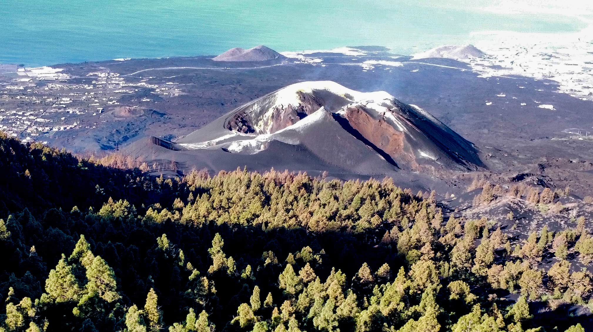
View from the hiking trail on the Tajogaite
The new volcano created by the eruption, eventually named Tajogaite, is 1120 metres high. The main crater has an average height of 172 metres. However, Tajogaite consists of a total of 6 craters. The name Tajogaite is said to belong to an area in the municipality of El Paso, according to Wikipedia, and comes from old records dating back to the 18th century. Employees of the National Park Centre, on the other hand, told me that Tajogaite is a name from the language of the indigenous people of the island of La Palma.

View from the hiking trail over ash fields to Cumbre Nueva
Hike above the Tajogaite
When I came to La Palma once again for hiking in November 2022, I naturally wanted to see Tajogaite. As there were still toxic fumes in the immediate vicinity of Tajogaite, no one was allowed to get too close to the volcano. I looked at it from El Paso and from the new road from below. But finally I found a little hike not far from Tajogaite.

Hiking trail over ash slopes through the pine forest
On this little hike you walk high above the Tajogaite, so to speak, and look down on it. The entire 7.5-kilometre hike is marked by the effects of the recent volcanic eruption. You see charred trees and a lot of ash. In some places, even the hiking trails are not so easy to „find“ again. But don’t worry, you can’t get lost on this little loop.
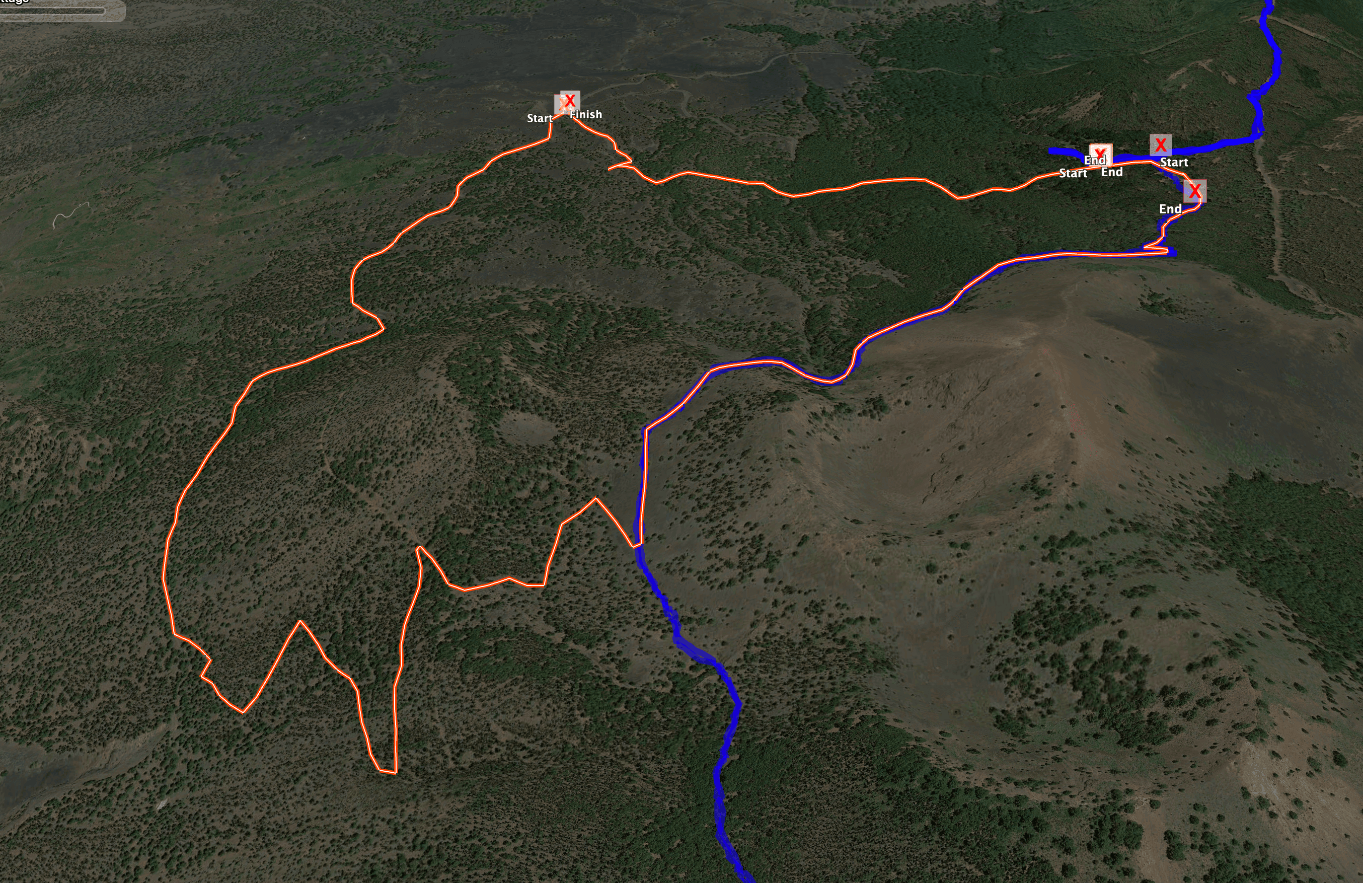
Track of the hike La Palma over the Tajogaite
General Information Tajogaite Hike
Starting point and approach
The starting point of the hike is a small viewpoint on the LP-301, the Mirador Astronómico del Llano del Jable. This is on the ramp to the well-known El Pilar rest area.
Arrival by car
Coming from the east or west on the island road LP-3, shortly after the tunnel exit towards El Paso, the LP-301 branches off towards the El Pilar rest area. Follow this road uphill for a while until you reach the aforementioned mirador. You can park in some of the car parks at the mirador or on the road.
Arrival by bus
Article summary and large selection of GPS hiking tracks
Sign up for my newsletter now and get exclusive access to my collected GPS tracks as well as all the brief information about my articles.
Sign up nowIt is not possible to get to the Área Recreativa El Pilar by bus. Alternatively, you can take a taxi to the starting point.
Time
I don’t like to give general times for hiking tours, because the times are very individual. This hike took us a little less than three hours. However, in addition to a long rest, we also had long stops to take photos and drone photos. Therefore, you should be able to walk this small loop in 2 hours without any problems.
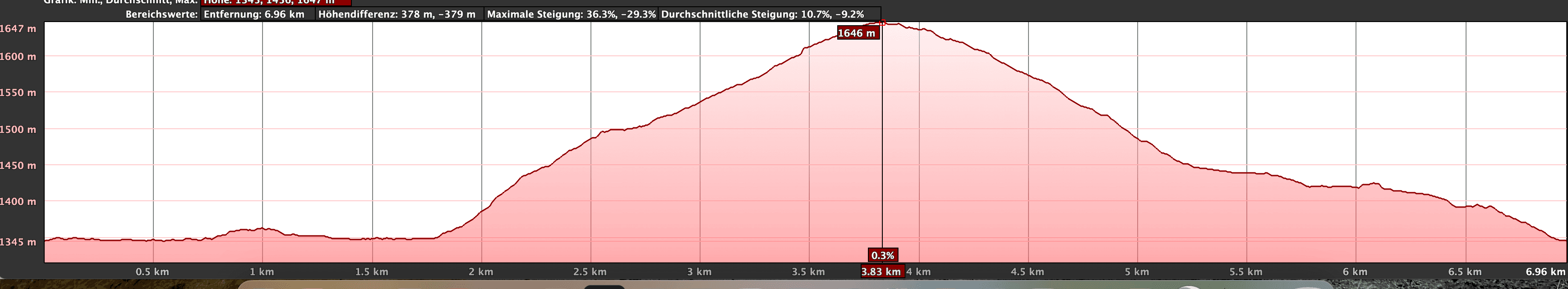
Elevation profile of the hike over the Tajogaite La Palma volcano
Altitude difference and route length
The difference in altitude is 300 metres and the route is about 7.5 kilometres long.
Requirement
This little loop is really an easy hike for everyone.
Refreshment
You will not find any restaurants, bars or shops along the entire route. Therefore, please take enough water with you for this short loop.
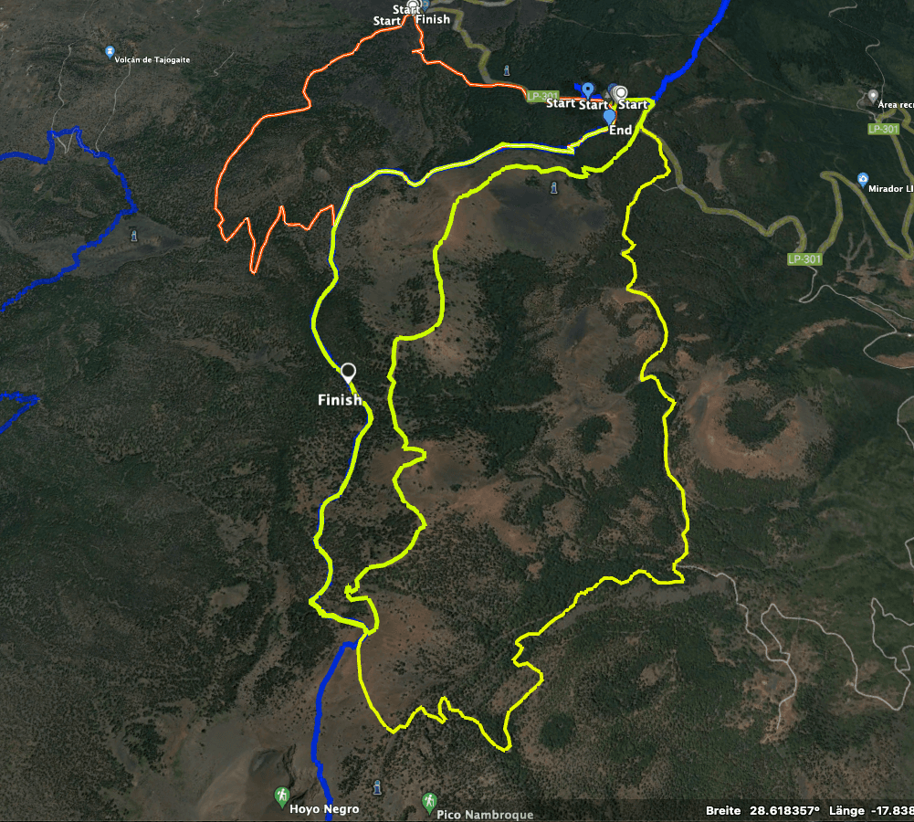
Track of the Tajogaite hike (red and partly yellow) and neighbouring tracks
Variants
The loop of this tour can be combined or extended very well with some hikes around El Pilar.
From El Pilar I have described on SiebenInselns so far:
- 1.0
- 2.0

View from the hiking trail over to the Cumbre
Hike above the Tajogaite
Article summary and large selection of GPS hiking tracks
Sign up for my newsletter now and get exclusive access to my collected GPS tracks as well as all the brief information about my articles.
Sign up nowSection Mirador Astronómico del Llano del Jable to the viewpoint Tajogaite
You start your hike high above the Tajogaite volcano at the Mirador Astronómico del Llano del Jable. A wide forest path secured by a barrier begins there. When I was there in November 2022, only selected vehicles were allowed to pass through at certain times. Access was secured by employees of the National Park Authority. However, you can walk through at any time. You follow the road straight ahead for quite a while. There is still a lot of ash from the volcanic eruption on the side and on the road.

Starting point of the hike Parking lot at LP-301
You walk through the pine forest and many trees are charred black. But already one year after the eruption, a lot of new green has sprouted again. After walking about two kilometres, you can see the Tajogaite volcano below you on the right. From the hiking trail you have a beautiful view of the volcano through the pines. You can’t get any closer to Tajogaite while hiking, as the forests to your right are closed to people.

the new volcano Tajogaite high above the Ariadne valley on La Palma
Section View Tajogaite to Hiking Trail Ruta de los Volcanes
When you have seen enough of the Tajogaite volcano from above, continue straight ahead on the forest road for a short while. After a while, the road goes slightly downhill again. At this point you will find a small path on the left uphill through the pine forest. The path is not easy to find at the beginning, as it is covered with a lot of ash. Then it becomes clearer.

Branch off hiking trail from the road via a narrow path up through the pine forest
You hike uphill through the pine forest in several large serpentines on this path, which is also a real path in parts. Finally, you reach a road, which you follow around to the right. The road takes you further up through the pine forest in serpentines, some of which you can shorten. At the end of a steeper climb, you will finally reach the well-known Ruta de los Volcanes hiking trail.

Hiking trail leads a little along the Ruta del Volcano
Section Hiking Path Ruta de los Volcanes to Mirador Astronómico del Llano del Jable
Follow the hiking trail around to the left. First you go uphill for a while. You will skirt the Birigoya volcano at its foot. Then you descend on the well-maintained hiking trail through the pine forest to the Área Recreativa El Pilar. Cross the entire rest area and continue until you reach the LP-301 road, which you follow around to the left for a short while. Then a wide forest path leads off to the left of the road. Continue along this forest road through the pine forest.

Hiker on the way down to El Pilar
After a while, the forest road makes a sharp left turn. However, you continue straight ahead, almost without a path. You go down over ash-covered slopes into a small valley. There you will find some tracks. From here, with and without a path, you simply go slightly downhill through the ash and the pine forest. After a short while, the path meets the Mirador Astronómico del Llano del Jable, your starting point, at LP-301.

Hiker on the hiking trail - forest road
And finally
I hope you enjoyed this little hike through the pine forests and black ash mountains high above the Tajogaite volcano. For me, it was very exciting to discover the new volcano Tajogaite in this way. I wish you much joy on all your hikes,
Dagmar from Siebeninseln