Note
The Environment Agency has asked me to clarify the following things that you should know and be aware of: The route leads through highly dangerous areas and off the approved paths as well as approved hiking trails. At the same time, it points out that it is forbidden to cross the tunnels located in this nature reserve, as stated in Decree232/2008 of 25 November, which regulates the safety of persons during underground hydraulic works and installations in the Canary Islands. Entry is only permitted for the maintenance of this infrastructure or for inspections. This applies to all tunnel walks. Therefore, this hike is only suitable for viewing, but not for re-hiking.
To Barranco Natero through tunnels and over the White Channel
Map
Today’s circular walk, with the Barranco Natero at its centre, is a real highlight for demanding hikers. The hike leads you from the small mountain village of Tamaimo through a tunnel to the so-called White Channel. You follow this watercourse high above the Barranco Seco to below the volcanic rock Risco Blanco. 
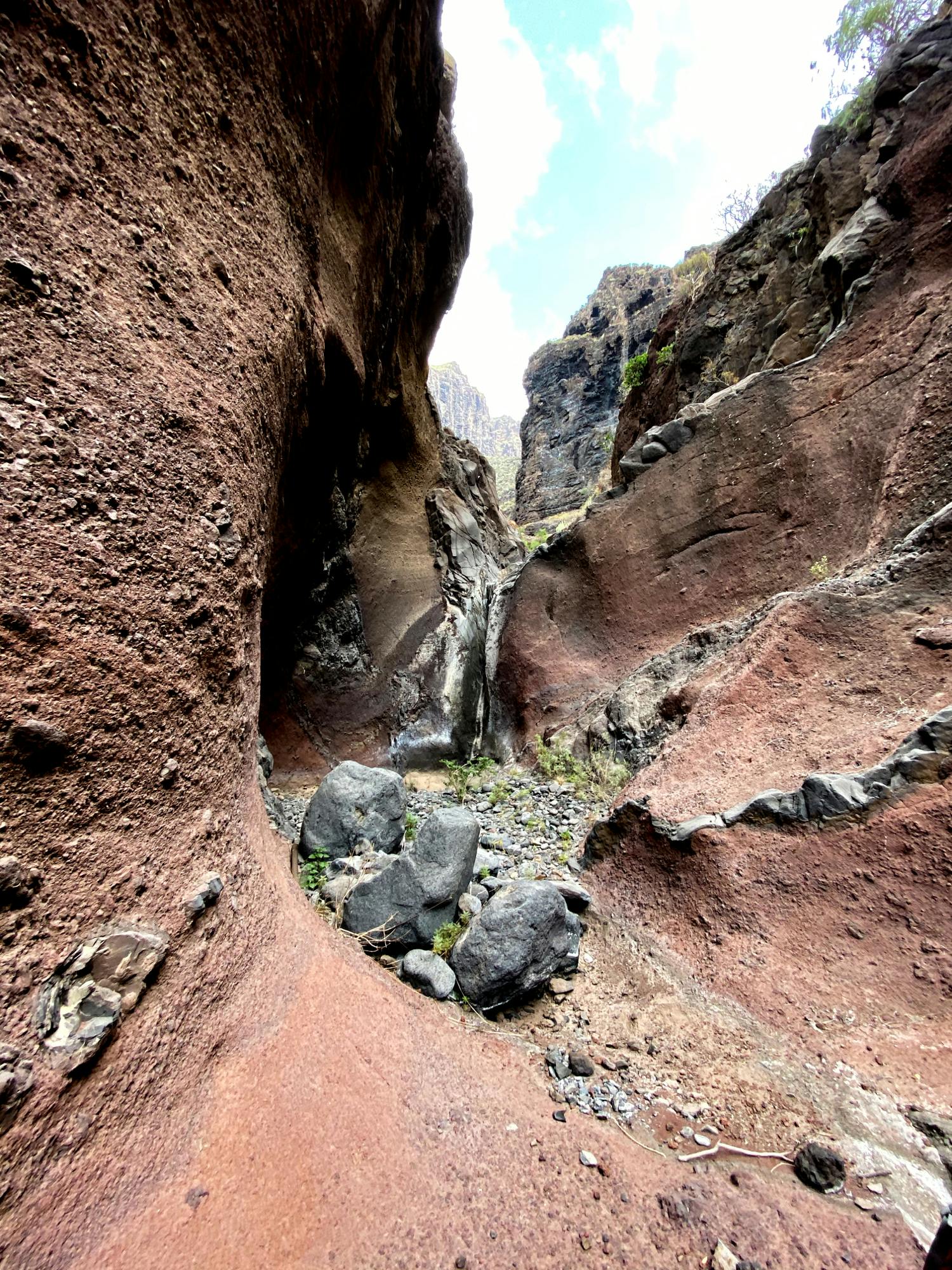
in the lower section of the Barranco Natero
Through another tunnel you reach the Barranco Natero below the Risco Blanco. After a short descent on a channel from a side gorge, you will reach the lonely and wild Barranco Natero at a Galería. 
Hiking trail on the upper edge of the Barranco Natero
Untouched wild nature, old galleries and fantastic views await you there. The descent is long and arduous. Finally you will reach the 500 meter long stone beach Playa Seco. Cross the beach and continue south until you reach the gorge exit of Barranco Seco. The ascent in Barranco Seco is not as difficult as the descent in Natero. Here too, you are surrounded by wild nature and the impressive rock faces of the gorge. Back you go through another tunnel into the Barranco Santiago and to Tamaimo.

Hiking along the White Channel
Barranco Seco and Barranco Natero – a few words about terminology
I have already described a hike through the Barranco Natero and the Barranco Seco on Seven Islands „It doesn’t always have to be Masca“. The terminology I used is based on the Rother Wanderführer, who calls the parallel Barranco to Barranco Santiago Barranco Seco. In the meantime I have found out that this Barranco is also called Barranco Mancha de Los Díaz. Probably this is the correct name. But because of the short form and the uniformity in the blog I will continue to talk about the Barranco Seco in the following. 
Beach Playa Seco
Also the Barranco Natero is called in some maps as Barranco Hondo. On other maps, only the upper part of the Barranco Hondo is mentioned. A third variation speaks of the Natero and calls it Barranco Seco in the lower part. I will refer to the Barranco only as Barranco Natero in the following. When I speak here about the White Channel, I mean exactly the Canal Galería el Sauce. It is called the White Canal, as the water that runs off from and in the canal has deposited calcium salts when it evaporates. These are white sinterings, that is, rocks formed by gradual mineral deposition. These white layers of rock, which are also increasingly found in the central part of the Barranco Natero, are often thought to be calcareous deposits.
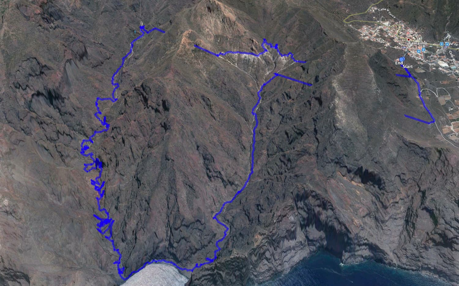
Track of the hike from Tamaimo across the White Channel and back through the Barranco Natero and Barranco Seco
General information about the circular walk Tamaimo – White Channel – Barranco Natero
Starting point and approach
Starting point is the end of the cul-de-sac calle Magarza in Tamaimo. This point is particularly convenient as you can park there very close to the Camino Real hiking trail. Of course, you can also start the hike from any other point in Tamaimo.

View from the upper Tamaimo Tunnel into the Barranco Santiago and to the coast
Arrival by car
To reach Tamaimo by car from the north, take the TF-82 in the direction of Santiago del Teide, or from the north and south, take the TF-1 motorway and exit at Chio. Then continue on the TF-82 to Tamaimo. From the south, take the TF-454 towards Los Gigantes and there is plenty of roadside parking on the main road Carretera Puerto and also on the TF-82. You will reach the exact starting point when you turn towards the church on Calle Santa Ana, which is near the Bar Girasol. Turn left at the church, drive along the church square and then right down a steep road to the end. There is ample parking available here.
Arrival by bus
The Titsa bus lines 325 (Puerto de la Cruz-Los Gigantes), 460 (Icod de los Vinos-Costa Adeje), 462 (Guía de Isora-Los Gigantes) stop in Tamaimo. You can find more information on the Titsa Homepage. Time
I don’t like to give general time indications for hiking tours, as the times are very individual. We needed for this hike with some small photo breaks and a longer rest on the beach almost exactly 6 hours.
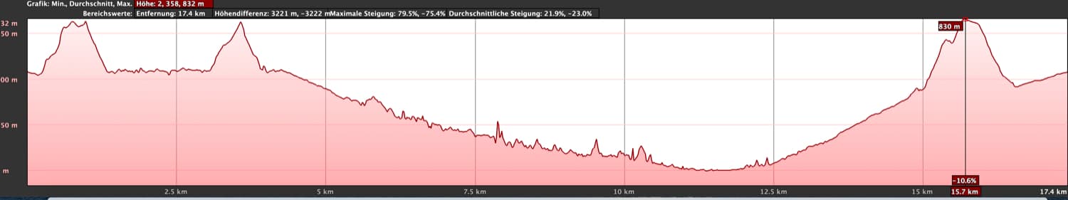
Elevation profile of the hike White Channel - Barranco Natero
Difference in altitude and distance
The difference in altitude is about 900 meters in ascent and descent. The route is about 17 kilometres long.
Request
Article summary and large selection of GPS hiking tracks
Sign up for my newsletter now and get exclusive access to my collected GPS tracks as well as all the brief information about my articles.
Sign up nowA difficult hike for those who are not only in good physical condition but also have a good head for heights and are sure-footed. The tunnel crossings are possible without problems and without danger. The hiking trail on the White Channel is also easy to walk, except for a few places. It becomes a little difficult when descending from the tunnel below the Risco Blanco on the canal into the Barranco Natero. In the lower part of the Barranco Natero it will not only be difficult to find the paths around the single Barranco sections that cannot be passed. These small paths are also often quite steep and impassable. At several places you have to scramble a little bit. So this is the right way for someone who is looking for a little challenge.
Do not forget a headlamp or a strong torch for the tunnels.
Refreshment
Restaurants, bars and shops can only be found in Tamaimo at the start and end of the hike. Therefore, bring sufficient water and food if necessary.
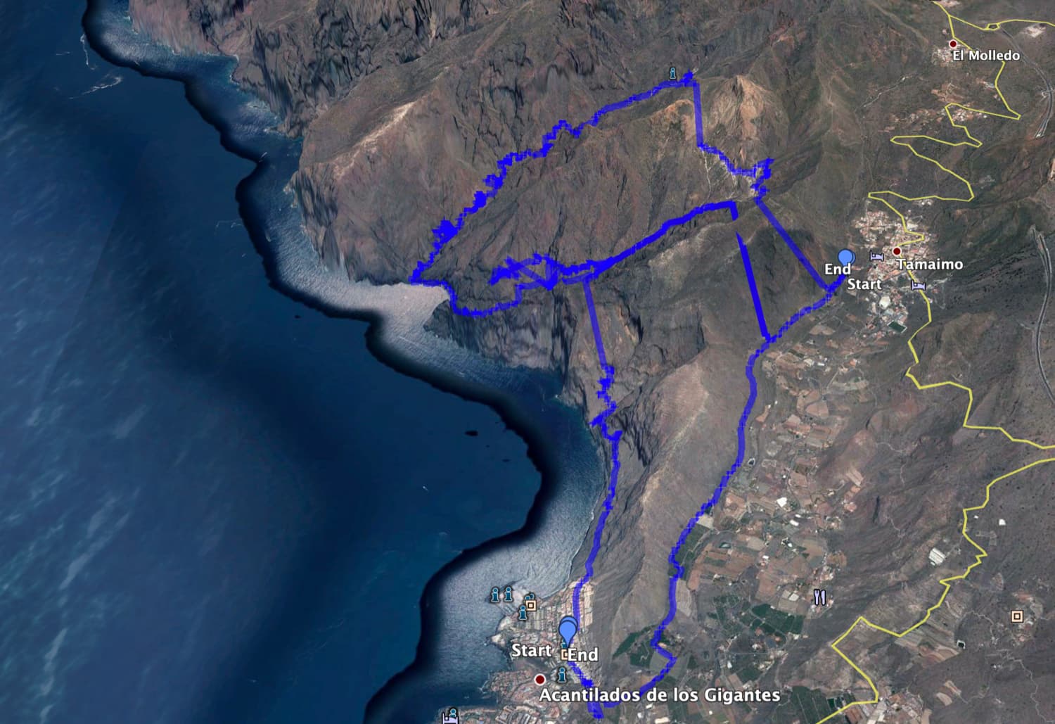
Hike White Channel - Barranco Seco in combination with the tour over the Acantilados and Barranco Seco
Variations
This tour can be easily combined with various other hiking and circular hikes in the vicinity. Especially the double tunnel tour is worth mentioning. You can also start the hike in Los Gigantes and enter the Barranco Seco through the lower tunnel. Then you hike up the Barranco Seco to the White Channel. Then – as described here – and through the lower tunnel back to Los Gigantes. If this hike is too long and strenuous for you, you can also simply walk through the first tunnel and descend into the Barranco Seco. Depending on the condition, the descent can be up to the beach of the Barranco Seco. Just walking a little in the lonely Barranco and looking at the old gallery buildings can be a wonderful hike.

partly the hiking trails are a little bit slippery in the Natero
Hike Tamaimo – Tunnel – White Channel – Tunnel – Barranco Natero – Playa and Barranco Seco
Tamaimo section to plateau after the first tunnel Canal Galería el Sauce
You start your hike at the above mentioned starting point in Tamaimo. From the end of the road it is only a few steps and you are standing in the middle of the Barranco Santiago on the hiking trail from Puerto de Santiago to Santiago del Teide (PR TF-65). You follow the path down to the left. After a very short time you will see a white canal above you on the right. A small path leads you steeply up the slope on the right side of the path. Then it is only a few steps along the canal and you reach the gate to the first tunnel.

Tunnel entrance White channel
This tunnel is about 1,070 meters long and easy to cross. In general it is high enough. But if you are very tall, watch your head a bit. This upper first tunnel (Tunel 1 Boca Norte – Canal Galería el Sauce) connects the Barranco Santiago with the Barranco Seco. You come out of the tunnel on a small plateau. Around you are the white deposits described above. You can descend to the left downhill to the main path through the Barranco, which connects Playa Seco and Tamaimo with a path above the mountain.

Walking through the "White Tunnel"
Section Plateau behind the first tunnel Canal Galería el Sauce to the entrance of the second tunnel below Risco Blanco
But you cross the plateau and follow the White Channel further on. After a short time you cross the „normal“ hiking trail through the Barranco Seco. Your path goes straight on. From time to time you can walk „safely“ in the channel. Then the path runs again on the left side of the canal. You can enjoy beautiful views down into the Barranco Seco. At some places you should be careful, because the path is a little bit sunken.

the White Channel with the Risco Blanco in the background
Finally the canal crosses the upper part of the Barranco Seco below the mighty volcanic rock Risco Blanco in an acute angle. From there the canal path runs directly below the Risco Blanco. It crosses in a wide arc a foothill of the Risco Blanco from the east as well as the south side. On the south side you finally reach the second tunnel. Here, only the lower half of the grating is open, so that you have to bend down a little to get into the tunnel.

Exit after the tunnel crossing under the Risco Blanco - side canyon of the Barranco Natero - further canal path on the right
Section entrance of the second tunnel below the Risco Blanco to the Barranco Natero (Galería)
This tunnel is shorter than the first one and covered everywhere with white sediments, which even covered the rails on the floor of the tunnel. Therefore this tunnel is also smaller in height, so you have to walk stooped and watch your head. Finally, after crossing the tunnel, you will come out in a small side gorge that starts from Barranco Natero. Here you can either climb down to the Barranco Natero at the ground of the Barranco or continue to follow the White Channel. We have chosen the second option.

Tunnel gate White Channel - Risco Blanco
First you cross the ground of the Barranco below or on the channel. Then you follow the canal further. This will take you in a large arc and through small tunnels (no lamp necessary) to former Galería buildings, which are opposite the actual Galería. From here you can descend on a stony slope. Now you are directly in the Barranco Natero below the Galería. Here too, you will find white calcium salt deposits and remains from the work of the gallery (rails, wagon parts).

Barranco Natero - original and wild
Section from Galería Barranco Natero to the second Galería Barranco Natero
From the Galería on, you first keep going downhill further and further in the middle of the Barranco. The path with the white sediments is already clearly visible from a distance. It changes from one to the other side of the Barranco in order to then, at times, walk straight through the Barranco again. Sometimes you also have to overcome quite big stones and rocks. But due to the cairns the path cannot be missed. In the further course of this hiking tour, the path continues at the right side of the Barranco on narrow paths high above the canyon. Thereby, one can repeatedely enjoy some fantastic views over the canyon and in the distance, also already to the Atlantic Ocean.

in the central part of the Barranco Natero - white sediments and remains of the former Galeria
Article summary and large selection of GPS hiking tracks
Sign up for my newsletter now and get exclusive access to my collected GPS tracks as well as all the brief information about my articles.
Sign up nowDeep below you lies the Barranco bed. In some places the path is a little exposed, so that a head for heights and surefootedness are necessary here as well. In other places the path is slightly slippery due to rock falls and wetness or is covered by boulders. Every step must now be taken very carefully and cautiously. The further down it goes into the Barranco, the more untouched everything looks. At some places it looks as if there really hasn’t been a human being here for years.

Hikers in the Barranco Natero
Insertion: Tunnel in the Barranco Natero
There are many tunnels on both sides of the Barranco Natero. Some of them are closed and others end after some hundred meters. Then there are also connecting tunnels, like the one you just came through. From the Galería, after the white coloured rocks, you first pass two tunnels. One tunnel is about 480 metres 20 metres to the right of the path. It begins in a wet stream and is full of water. This tunnel leads through the rock massif into the Barranco of Masca. However, it is now closed (March 2020).

short climb
Another tunnel is located shortly after this point on the left side of the Barranco about fifty meters beside the Barranco bed. This tunnel is dry and leads towards Barranco Seco, but is not supposed to be continuous. Who likes and has time can go into this tunnel a little. Further down in the Barranco Natero there is another tunnel at the right side that is at first quite flat and also leads into the Barranco of Masca.

partly to climb a little bit to descend in the Barranco Natero
Section of the second Galería Barranco Natero to a small meadow on the right side of the Barranco
After some time you will pass another ruin on the left side of Barranco Natero, which lies deep below you at first. You walk high up on the right side of the gorge on a very narrow path. The path leads along the rock and you can look down to the white abandoned house in the Barranco bed. From here the path gets steeper and steeper and winds down the right side of the slope towards the barranco bed. From here on the Barranco itself gets narrower and narrower. Now it goes partly steep in the barranco bed and then downhill again on the side of the slopes.

Stairs in the Barranco Natero to the ground
You finally reach a very narrow place where only an experienced climber with rope could continue in the Barranco. At least that is how it looks at first sight. But actually there is a possibility to pass this place on the right side of the Barranco uphill. You walk along a rock cave at the top right. Afterwards you descend in serpentines to a small meadow. You cross this meadow on a rather overgrown path that widens the gorge for a short time.

in the lower section of the Barranco Natero
Section small meadow on the right side of the Barranco to Playa Seco
After the meadow the path immediately leads you again closely along a rock, which you bypass on the right. Then it goes steeply down again on paths with lots of scree towards the Barranco ground. At one point the path, which once led down to the Barranco in serpentines, is buried by rockfall, so that you have to work your way down over the stones. The gorge now becomes so narrow that the path between the vertically rising rocks is only possible in the Barranco bed. Here there are always large rocks that have to be climbed over. At one point there are steps carved into the red rocks. On these rocks you can descend further into the bed of the gorge as if you were on a ladder.

Colour play in the Barranco Natero
Now there are some places where you actually have to climb a bit. And once again you will come to a place where it seems to go no further. You are standing on a strong fall in the bed of the Barranco. Here you have to climb back a little. Then a very narrow path on the left side of the Barranco takes you up and down again steeply into the Barranco Natero. That way you avoid this place. From here on you continue between stones in the Barranco bed. After some time the Barranco widens and you see Playa Seco in front of you, which you reach after a short time. You are standing at the 500 meter long stone beach at the Atlantic Ocean with a view to Los Gigantes in the distance.

on the beach of Barranco Seco
Section Playa Seco to the junction of the lower tunnel (Acantilados)
After crossing the Barranco Natero, you have completed the hardest part of the hike, even though from now on the trail goes uphill. I have already described twice on Seven Islands, the tour through Barranco Seco from the other direction (It does not always have to be Mascaand Adventure Pur). In both articles you will also find many pictures of this section of the route. Therefore I keep the description here a little shorter. From the exit of the Barranco Natero you cross the 500 meter long stone beach, which is a little bit difficult. Then you walk uphill on the main hiking trail, which is much easier to walk than the trail through the Barranco Natero. At the exit at the sea, the Barranco is still wide. Then it becomes narrower as you continue. But here, the path is well marked by cairns. 
Exposed passage in Barranco Seco, which can now be bridged with rope
After some time you leave the Barranco bed on the left side on a steeply ascending path. You hike for a while up on the left side of the barranco. Then the path changes again through the Barranco to the right side of the Barranco. Here the path now goes steeply up to the water channel on the main path. You get onto the main path, which goes right to the lower tunnel that leads over the cliffs to Los Gigantes. However, keep left along the water channel.

Barranco Seco
Section lower tunnel (Acantilados) to Tamaimo
Now the main trail on the right side of the slope, which you can’t miss anymore, takes you up the Barranco Seco. After a short time a path branches off to the left onto the lower canal. But here you go straight ahead. After a long time the path crosses the Barranco Grund again and continues on the left side of the Barranco. It goes partly steeply uphill. At a wider spot with large stones and remains from the times of the Galería, like an old lorry, you cross the Barranco for the last time. Now the path continues on the right side along the canal. Then the wide serpentines begin, which continue along the main path until you reach the top. However, after the first serpentine road, you branch off to the left. A narrow path, which is sometimes a bit confusing, leads you up steeply.

Water channel in Barranco Seco
If you cannot see the path, always keep your mind on the upside when in doubt. Sometimes the path is also marked with red spray points. After some time you will reach the middle tunnel that leads from Barranco Seco to Barranco Santiago. It is quite long with its 1200 meters. However, despite the fact that some of the tracks are on the ground, it is very easy to walk through. On the other side of the tunnel you are too fast on the main hiking trail (Camino Real PR TF-65 Puerto de Santiago – Santiago del Teide), which you follow uphill to the left. You will pass a goat farm and soon after that the upper tunnel where you started. Shortly afterwards you will return to the starting point of your hike in Tamaimo.

Barranco Seco - Galería de la Junquera
And finally
I hope you enjoyed the hike into the Barranco Natero over the White Channel and through the tunnels. A really adventurous hike. And if you lack the spirit of adventure for it, I hope you will find your personal favorite hike elsewhere in Seven Islands. Many thanks to the Norwegian Iain Schroeder who showed me this great hike. Have fun hiking,
Dagmar von SiebenInseln