On the Cresta de Las Cañadas to Degollada de Ucanca
n the Teide National Park lies the large plateau of the Cañadas del Teide, which is surrounded by an impressive mountain range. You can hike along the top of this mountain range, the Cresta de Las Cañadas. From up there you have the most beautiful views of the caldera, the Cañadas, the Teide and the eastern side of the island. If the sky is clear, you can also see the neighbouring islands of La Palma, La Gomera, El Hierro and Gran Canaria.
Map
The Cresta de Las Cañadas high trail runs from behind Boca de Tauce to El Portillo. You probably won’t do it in one go. But you can split this long trail very well. I described part of the hike over the Cresta de Las Cañadas in the article Siete Cañadas. This is the section between El Portillo and the Parador. On the Cresta de Las Cañadas it ends on the Degollada in front of the Guajara. Heading west, the high trail then continues over the Guajara to the Degollada Ucanca. You can find the description here.
View of Teide and Pico Viejo from the Cresta de Las Cañadas
The missing part of the Cresta de Las Cañadas – a great challenge
The missing part of the Cresta de Las Cañadas between the Degollada de Ucanca and Boca Tauce is the difficult part of the whole high-altitude hike. But with good physical condition and a bit of scrambling, it is manageable. Here I describe the ascent to the Cresta de Las Cañadas from the TF-21 to the Sombrero. Afterwards, we continue on the high trail over several peaks. The most impressive of the peaks is Roque del Almendro, from which you can enjoy a fairly steep descent.
After a third of this trail, you will join trail S-31, which will take you further over the Cresta on slightly better trails. At the end of the hike, you will reach the Degollada de Ucanca in front of the Guajara. From there you descend to the Parador. This is a really fascinating hike with a little climbing, which is not for everyone. But if you are fit enough, have no giddiness and are sure-footed, you will enjoy this tour.
Track of the hike on the Cresta de Las Cañadas (light blue)
General information about the Cresta de Las Cañadas hike
Starting point and route
Start point of the hike is the TF-21 between the rest area Las Lajas and Boca Tauce – GPS: 28.205781, -16.674622. End of the hike is at the Parador in the Teide National Park.
Approach by car
You will come to the TF-21 at Boca Tauce on all Teide access roads, unless you have already driven via Vilaflor on the TF-21 towards Boca Tauce. There are a few parking spaces on the edges of the road. You will probably have to walk a little from there to the starting point. Since the end of the hike is at the Parador, you would need to organise this hike with two vehicles if possible. You may also be able to take a bus tour or have someone take you or pick you up.
Approach by bus
Titsa buses 342 and 348 run along TF-21, but they are very limited so you will need to plan carefully. The closest bus stops to the start of the hike are Boca Tauce and the Las Lajas rest area, so you would need to hike from there to the start point. Boca Tauce is closer to the starting point of the hike. But from Las Lajas you can also climb up to Cresta de Las Cañadas. This is also an option to skip the very difficult part of the hike. I describe this route in detail in the section on variants. You can find more information on the Titsa homepage.
Time
I don’t like to give general times for hiking tours, as the times are very individual. We needed about 8 hours for this round tour with a few stops and rests.
Altitude profile of the hike on the Cresta de Las Cañadas
Article summary and large selection of GPS hiking tracks
Sign up for my newsletter now and get exclusive access to my collected GPS tracks as well as all the brief information about my articles.
The difference in altitude is just under 740 metres and the route is about 11 kilometres long.
Requirements
For this hike you need not only a good physical condition, but also absolute surefootedness and a head for heights. In the first third, I can actually no longer describe this hike as a pure hike, but as a hike with climbing interludes. Therefore, absolute caution is advised. Under no circumstances should you undertake the hike in bad weather or during a storm. The last two thirds of the hike are still demanding, but follow the small hiking trail over the Cresta de Las Cañadas S-31. The first third of the hike with some climbing took a lot of time, so you should definitely allow enough time for this undertaking.
If you want to avoid the climbing and scrambling, you should skip the first third of the hike and ascend on the normal trail from Las Lajas and then go to the Parador via the Cresta de Las Cañadas.
Warning: even the track I provide in the download area is only conditionally suitable, as we ourselves tried to find the way in the first third of the hike, which was partly only possible via some detours. Therefore, please read the following description carefully, as I will point out some special features of the hike there.
Refreshment stops
There are no refreshment stops until the end of the hike at the Parador. Therefore, please take enough water and, if necessary, food with you for the hike.
Track of the hike on Cresta de Las Cañadas (light blue and down to the Parador yellow) and neighbouring tracks
Variants
If you want to shorten the hike and/or avoid the rather exposed first part of the hike, you can start the hike on trail S-31 at the Las Lajas rest area. From there, you climb parallel below the Cresta de Las Cañadas and reach the Cresta above the Sombrero de Chasna.
Hiker on the high trail along the Cresta de Las Cañadas
Hike Cresta de Las Cañadas
Section TF-21 to El Sombrero
You start this hike on the TF-21 (GPS data above) at the third big bend behind Boca Tauce. On the inside of the bend, the path takes you briefly over scrubland and then into wooded areas. There are a few paths, but they all lead uphill to the ridge, the Cresta de Las Cañadas. Once on the ridge, the summit of El Sombrito (2326 metres) is to your left. However, the path continues to climb around to the right. Already from here you have the first wonderful views back to the ascent path and to the left into the caldera.
Start of the hike between Las Lajas and Boco Tauce on TF-21
The ascent is still quite steep. In front of you rises the summit of El Sombrero (2532 metres). And now you have to pay a little attention. After a while the ascent path splits. We kept to the right and walked along below El Sombrero. So did my track. That went wonderfully for some time. But then we had to cross a large white scree field. That was quite a slippery affair. So I would not advise anyone to walk along in front of El Sombrero. Instead, use the ascent path around to the left. It leads you along the left side behind the summit.
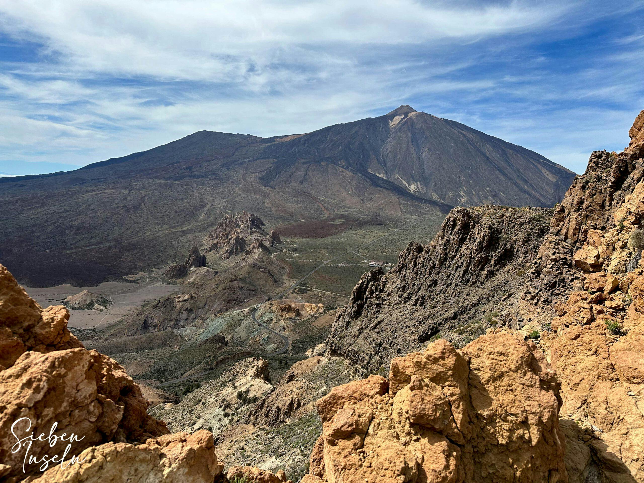
View from the Cresta de Las Cañadas to the western heights, such as El Sombrerito (2326 metres altitude), of the Cañadas and to La Gomera and La Palma
El Sombrero to Roque del Almendro section
At the end of the peak, the path crosses back to the other side and brings you down on a ridge. On the ridge, the descent path finally meets the path that runs in front of El Sombreo. You now walk slightly downhill parallel to the ridge for some time. You cross a small depression. Afterwards, the trail goes uphill again to Roque de los Almendros. With beautiful views of the Teide, the neighbouring islands and the caldera, you continue straight uphill. Now and then the path is a little difficult to find, but in the end you know the direction.
Paths past large rocks in front of a steep face between El Sombrero and Roque del Almendro
Article summary and large selection of GPS hiking tracks
Sign up for my newsletter now and get exclusive access to my collected GPS tracks as well as all the brief information about my articles.
And I have seen on various tracks that there are indeed different possibilities. One path runs pretty close to the top of the ridge. And another path is offset a little further down. You cross the Baranquillo de Erques. Then the path goes up again close to the ridge. It then descends again for a short while and then climbs steeply. At the top of the ridge, you walk behind a rock on the left to then climb straight up or in a curve to the summit of Roque del Almendro (2524 metres).
View back to the summit of El Sombrero
Route section Roque del Almendro to junction with hiking trail S-31
Once you have reached the summit of Roque del Almendro, continue forward to the edge of the cliff. Here you will find a steep stone path leading down. You actually have a very narrow, but also very steep path, which you have to really climb down in parts. The view down to the Cresta de Las Cañadas is fantastic.
Hikers descending from Roque del Almendro
When you reach the bottom, you cross a hollow and climb back up to the ridge on a clear path on the other side. Now the path runs partly through and over large boulders for a long time along the mountainside. You keep moving parallel to the Cresta de Las Cañadas. Finally, the path climbs. At two different points you have the opportunity to cross the ridge through a rock passage. Once you reach the other side of the rock wall, you will again have wonderful views over the caldera.
Climbing the ridge
Follow a clear path down the slope, cross a hollow and reach a clearly marked path on the other side. Follow it around to the right. The path goes downhill and after a short while brings you to the S-31 trail. The S-31 comes up here from Las Lajas. If you want to avoid the sometimes uncomfortable scramble up to here, you can climb up to this point on this good trail.
Hikers on the descent of Roque del Almendro
Route section crossing trail S-31 to last climb on Cresta de Las Cañadas
The S-31 continues for a while on top of the Cresta de Las Cañadas. To your right is the Sombrero de Chasna (2405m). To the left you have really impressive views down into the caldera and over to Teide. Two paths branch off to the right to the Sombrero de Chasna. You go straight on and then climb up to another peak. After that you have two options. We walked along a path at altitude at the next summit. The S-31 runs a little further down.
Trail S-31 over the Cresta de Las Cañadas with Gran Canaria in the background
After a short descent, the path turns uphill again on the mountainside. Once you have mastered this ascent, you walk from there for a very long time parallel to the ridge. Then you cross a small rock wall and walk uphill again parallel to the wall. Finally you reach a small plateau, which you cross. From there, the trail descends in a wide arc to a saddle. From there, your last major ascent is on the right side of a large rock.
Hiking trail Cresta de Las Cañadas S-31 - in the background Guajara
Route section last ascent on the Cresta de Las Cañadas to the Parador
After this climb, you will reach the open ridge again, where the path continues to climb a little further. But behind two high peaks, the trail slowly descends. You walk along the slope for a long time. Then you easily cross the ridge and find yourself on the Degollada de Ucanca in front of the Guajara. Continue straight on to the Guajara. However, you descend to the left with the S-31 downhill towards the Parador.
The path is well marked and cannot be missed. Once you have completed the first long descent section with a few switchbacks, the path leads you downhill to the right through a valley. Finally, you will come to the Siete Cañadas road, which you cross. Continue straight ahead on the trail for a while until you reach the Parador. When you reach it after the long hike, you can really congratulate yourself. A great challenging tour lies behind you.
Hiker on the S-31 trail in front of the Parador
And finally
I hope you enjoyed this really difficult and challenging hike over the Cresta de Las Cañadas. For me, this hike with the most beautiful views and the great variety is one of the king tours on Tenerife. But you decide for yourself. I wish you safe and beautiful hikes,
Dagmar from Siebeninseln
Thank you for reading!
If you've found my hiking guides on SiebenInseln helpful for your Canary Islands adventures, please consider leaving a small tip. Your support is greatly appreciated and helps cover the costs of maintaining this blog.