Barranco de los Cochinos – wild gorge with some surprises
In the northern part of the Teno Mountains lies the Barranco de los Cochinos (the Canyon of the Pigs). In the upper part of this gorge I had already described the hike over the Cuevas Negras and the hike through the water tunnel.
Map
every now and then there is a lot of water in the Barranco de los Cochinos
This hike through the lower part of the Barranco de los Cochinos starts in Los Silos. It takes you past a pond and then to the Galeria la Escalera (the Stairs Gallery). Here you will find not only water pipes, but also a staircase with many steps.
Galería Escalera
As the barranco is very narrow at this point, the narrow stairs will take you to the next level. And through a sunken door you finally leave the Galería on the continuation of the stairs. This is a very impressive setting, which bears witness to the extensive water extraction activities that took place in this barranco in the past. You will climb higher and higher on very steep paths along the edge of the gorge. Eventually you will reach more remains of old gallery construction activities.
a ruined house above the barranco
Barranco de los Cochinos with many hiking opportunities
Once you have visited the worthwhile tools in the upper part of the Barranco de los Cochinos, you can choose between several options. Of course, you can go back the same way and see all the adventurous things again. But you can also cross the water tunnel and then descend on the normal hiking trail to Los Silos or, alternatively, climb up to Erjos.
Hike through the water tunnel
I have described two tours here. The larger tour takes you a little further through the Barranco de los Cochinos. You then climb up the right side of the slope and finally reach the PR TF 54 hiking trail, which also runs from Erjos to Los Silos. You can find the description here. The smaller tour takes you through the water tunnel to PR TF 53, on which you descend to Los Silos. Whatever you decide, the Barranco de los Cochinos offers many more options for individual exploration.
Tracks of the hikes through the Barranco de los Cochinos (green large loop, red water tunnel)
General information about the Barranco de los Cochinos circular walk
Starting point and route
The starting point of the hike is the church square of Los Silos on Calle Susana.
How to get there by car
From the north, take the TF-42 coastal road to Los Silos. Or from the south, you can take the TF-1 motorway to Santiago del Teide. From there, continue towards El Tanque on the TF-82. After El Tanque, turn left onto the TF-421, which will take you down to the TF-42 coastal road. From there, turn left to Los Silos. There is plenty of parking in the large lot near the church on Calle Susana.
Getting there by bus
Article summary and large selection of GPS hiking tracks
Sign up for my newsletter now and get exclusive access to my collected GPS tracks as well as all the brief information about my articles.
The Titsa 363 bus route stops in Los Silos, if you would like to catch the bus in Erjos and/or find out more details about bus services, you can find all the information on the Titsa homepage.
Time
I don’t like to give general times for walking tours, as times are very individual. For the big round hike through the Barranco de los Cochinos we needed 5 hours with intensive visits to the Galería and a break. The round tour with the way back through the water tunnel took a little over 4 hours with a break.
Elevation profile of the hike Barranco de los Cochinos large (green track)
Difference in altitude and length of route
The difference in altitude for the large round tour is just over 700 metres. The route is just under 12 kilometres long.
On the return hike through the water tunnel, the difference in altitude is about 500 metres and the route is a little over 7 kilometres long.
Elevation profile of the Barranco de los Cochinos hike (water tunnel - red track)
Requirement
These hikes are definitely not easy tours. In addition to a little fitness, you need a head for heights and surefootedness. Some of the trail runs along very rough paths. If you plan to return through the tunnel, you should not be afraid of darkness and narrowness. You need shoes that can walk through water and a headlamp or a good torch. The last part of the hike, however, is on a well-marked hiking trail in both variants.
Refreshments
Restaurants, bars and shops are only available at the starting point Los Silos. Therefore, take enough water and, if necessary, food with you.
Variants
Tracks Barranco de los Cochinos (green and red) and neighbouring tracks
These tours can be combined well with various other hiking and circular walks in the vicinity. On Seven Islands you will find a description of the hike to the Cuevas Negras, through the water tunnel and to the waterfall Lomo Morín. All three hikes can be combined perfectly with these hikes in all directions, so that you can put together your own individual tour.
Hiking and exploring in the narrow Barranco de los Cochinos
Circular hike Barranco de los Cochinos
Los Silos section to water collection basin
You start the hike in the Barranco de los Cochinos at the large car park near the church on the TF-42 in Los Silos. Once you have crossed the TF-42, follow the road straight ahead on the opposite side of the car park (Calle Susana) for a very long time. At turning roads, keep straight on until you reach the PR TF-53 trail to the Cuevas Negras. Here the path is also called Camino Cuevas Negras. You cross a small stream on a wooden bridge. The hiking trail leads you out of Los Silos past fields, meadows and individual farmsteads. On the road, the ascent is already quite good from time to time.
Start of the hike on PR TF 53 in Los Silos
Article summary and large selection of GPS hiking tracks
Sign up for my newsletter now and get exclusive access to my collected GPS tracks as well as all the brief information about my articles.
Finally, the hiking trail to the Cuevas Negras PR TF 53 branches off to the left uphill from the road. You will come back here later if you choose the option of returning through the water tunnel. Now stay on the main path, which makes a large bend to the right. The path takes you through a lot of greenery and past fields into the increasingly narrow gorge of the Barranco de los Cochinos. You go under a small bridge and pass a small building. There is a sign „privado“. The owner takes care of many cats and has placed a box there in which she collects donations for feeding the cats. A short time later you will pass a large water collection basin with ducks swimming in it.
Duck pond and water collection basin in Barranco de los Cochinos
Water collection basin section to Galería Escalera
Leave the water basin behind you on the left. Discovering the Barranco de los Cochinos is a real pleasure for „explorers“. It is so green and there are so many little details and nooks to explore and discover. The Barranco de los Cochinos is very narrow and in between the path winds through a lot of green bush. You’ll find rare flowers, herbs and mushrooms and you’re guaranteed not to meet too many other hikers. Eventually you come to a place where a very steep-looking stairway leads up to the right. This path, which no longer looks so reliable, should lead up to Las Moradas de Abajo.
Small stairway to the right side of the hiking trail to Moradas Abajo
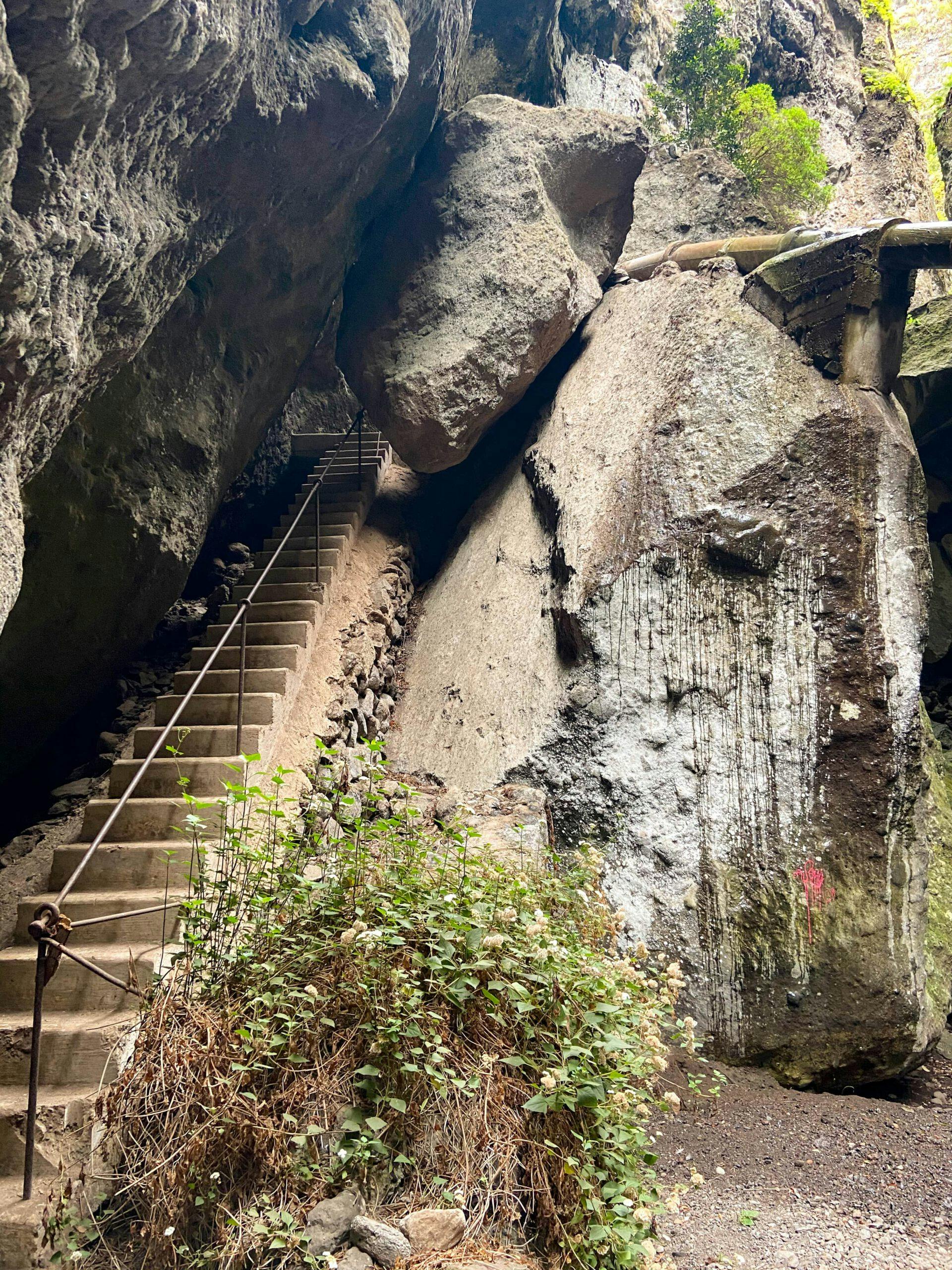
Continue straight on and after a short while you will reach the Galería Escalera. Here at the staircase Galería you should take some time to explore. You will find many old walls and things that bear witness to the construction of the water galleries. On a long staircase with a few steps, which probably gave the Galería its name, you go up „one floor“. From here you can once again look down into the lower, narrower part of the gorge. Through a door you continue on a staircase that takes you higher into the barranco.
Staircase at the Galería Escalera
Galería Escalera to water tunnel section
From Galería Escalera you continue walking in the middle of the narrow Barranco de los Cochinos. After rainy seasons, the stones in the stream can get a little wet and slippery. You will reach a point where you cross the Barranco bed from right to left. Here you can make a small detour straight ahead in the Barranco bed. However, this only works if the stream does not have too much water. But the actual hiking trail leads you very steeply up the left slope. From now on, the path is difficult to describe, but it can be found. It is a very narrow path that leads very steeply up the left side of the slope of the Barranco de los Cochinos.
Exploring the narrow Barranco de los Cochinos
Alternative: Return through the water tunnel (track red)
At a junction, keep to the right. You will pass an abandoned ruined house. In parts, the path leads directly along the slope. Below you is the Barranco de los Cochinos. After a while, when you have made a long bend along the slope, the path descends steeply into a kind of valley. At this point you are almost without a path, but you will see some cairns. The path to the right leads you along a covered water channel to the water tunnel. You cross the water tunnel with waterproof shoes and a good torch. On the other side of the tunnel, turn left and after a short while you will reach the main hiking trail PR TF-53, which you can use to descend to Los Silos.
Entrance water tunnel
Water tunnel section to Los Silos
For the large circular walk (track green), however, after the steep descent you keep to the left and walk past some old equipment left behind from the times of the Galería construction. You now follow the narrow path that always follows the course of the barranco. It takes you further up the Barranco de los Cochinos through the narrow valley, which is partly covered with lush bushes. Finally, the path climbs steeply on the right side in a few serpentines. After the steep ascent, you will reach a ridge. From up here you have a beautiful view over the northern Teno Mountains. Follow the ridge path for a while until you reach a wide path. Continue along this path to the right.
Hiking trail PR TF 53 from Erjos to Los Silos via Cuevas Negras with view of the coast at Los Silos
After a short while you will reach the PR TF-54 hiking trail that leads from Erjos to Los Silos. You can now follow it around to the right to Los Silos. You will descend with beautiful views of Los Silos and the north coast. If you are looking for a detailed description of the route, you can look here (LINK) at the description of the route to the Cuevas Negras. Otherwise, the trail is well signposted and you can’t miss it. At the end of the path, you descend in serpentines, pass under some water pipes and reach the first houses of the village. After some banana plantations and reeds, the path brings you back to Calle Susana. Follow it around to the left to the starting point of the car park in Los Silos.
Memory of times with tracks and active construction and water extraction activity in the Barranco de los Cochinos
And finally
I hope you enjoyed this varied and exciting walk. And if you can’t do it yourself, maybe you’ll enjoy the report alone. In any case, I am always happy to receive your feedback and comments. I hope you enjoy your hike,
Dagmar from SiebenInseln
Thank you for reading!
If you've found my hiking guides on SiebenInseln helpful for your Canary Islands adventures, please consider leaving a small tip. Your support is greatly appreciated and helps cover the costs of maintaining this blog.
Thank you for your support!
SSL secured
Comments
John Moorhouse - 05/03/21, 04:34 PM
We have run and hiked all over the Teno area and thought we knew everything about it. But – Dagmar keeps coming up with places and tracks we did not know existed and we can’t wait to get back to Tenerife to try them out. So, here is a big thank you to Dagmar for her excellent route descriptions and back up gpx files.
Dagmar - 05/03/21, 04:40 PM
Many thanks John for following and have fun hiking
Endru - 02/07/22, 02:04 PM
Unfortunately, they closed the water tunnel a few weeks ago. 🙁 ?
Dagmar - 02/07/22, 04:02 PM
I heard it is already from the side Cuevas Negras open again