Circular hike with circumnavigation of El Alto de Guamaso
This large circular hike from El Portillo first takes you on a small circular hike around the volcano El Alto de Guamaso. If you only want to do a short loop, this short hike around the volcano might be enough for you. But if you want a little more, you can take the GR 131 long-distance trail for a while, which takes you downhill along the Barranco de Guamaso through the pine forest.
Map
Sendero 14 to El Alto de Guamaso (in the background)
Finally, you leave the GR 131 and hike a loop through the pine forest around Montaña Roja. After an ascent through the forest, you will finally reach the wide plain above Fortaleza and El Portillo. With magnificent views of the Fortaleza and the Teide and many lizards as companions, you then walk uphill back to El Portillo.
Track of the hike El Alto de Guamaso
General information about the hike El Alto de Guamaso – Montaña Roja – El Portillo
Starting point and route
The starting point of the hike is the restaurant at the junction of the TF-21 and TF-24 roads in El Portillo.
Starting point of the hike El Alto de Guamaso at the road junction near El Portillo
Approach by car
You come from the north on the TF-21 via the Orotava Valley or via the TF-24 from Santa Cruz. From the south, take the TF-24 to El Portillo. Parking is available at the intersection in front of the restaurant or a little further up the TF-24 in front of the El Portillo Visitor Centre. Since you will pass by there anyway on the way back, you can also start this hike from there.
Approach by bus
Twice a day, Titsa buses 342 (Costa Adeje – El Portillo) and 348 (Puerto de la Cruz – Parador Nacional) run along this route, stopping at both the El Portillo Visitor Centre and the road junction in front of the El Portillo restaurant. More information and the exact times can be found on the Titsa homepage.
Time
I don’t like to give general times for walking tours, as the times are very individual. I needed a little over 4 hours for this round tour with a long rest.
Altitude profile of the El Alto de Guamaso hike
Article summary and large selection of GPS hiking tracks
Sign up for my newsletter now and get exclusive access to my collected GPS tracks as well as all the brief information about my articles.
The difference in altitude is just over 500 metres and the route is approximately 13.5 kilometres long.
Requirements
You hike the entire time on good hiking and forest paths.
Refreshments
There are only refreshment stops at the start and end of the hike in El Portillo. Therefore, please take enough water and, if necessary, food with you for the hike.
Track of the hike El Alto de Guamaso (blue) and neighbouring tracks Arenas Negras and Siete Cañadas (red)
Variants
If you wish, you can shorten the hike by only doing the loop around the volcano El Alto de Guamaso. You can also combine this hike with the Arenas Negras hike, which starts at the visitor centre in El Portillo, as an alternative to continuing downhill through the pine forest.
Another hike that also starts from the visitor centre is the hike up Montaña Blanca.
Circular hike El Alto de Guamaso – Montaña Roja – El Portillo
Section of road crossing El Portillo to El Alto de Guamaso
You start your hike at the road junction in El Portillo at an altitude of 2034 metres. From there you walk a short distance along the TF-24 towards Izaña. After a short while, you will meet the hiking trail on the left side of the road. You will return from your round here later. You can also leave the road here and turn right onto trail no. 14. Then keep to the right at the next fork. This will also take you to the circular route.
View from El Alto de Guamaso to the north coast of Tenerife
However, I wanted to walk a little further along the road to see the Mirador de El Alto de Guamaso. To do this, walk a little upwards along the road. At the first higher altitude you will find the Mirador El Alto de Guamaso. From there you can already enjoy beautiful views of the surrounding area and the volcano El Alto de Guamaso. Hiking trail no. 14 starts here and leads you straight and slightly uphill to the right side of the volcano.
El Alto de Guamaso hiking trail
Article summary and large selection of GPS hiking tracks
Sign up for my newsletter now and get exclusive access to my collected GPS tracks as well as all the brief information about my articles.
Route section road junction El Alto de Guamaso to junction GR 131
Now you hike once around the entire summit of the volcano El Alto de Guamaso on the well laid-out hiking trail. You will enjoy magnificent views of the Orotava valley and the north coast. When you are back on trail 14 at the TF-24, don’t go back to the road, but keep a little to the right. This is the start of the GR-131 long-distance trail, which descends in wide switchbacks along the left edge of the Barranco de Guamaso.
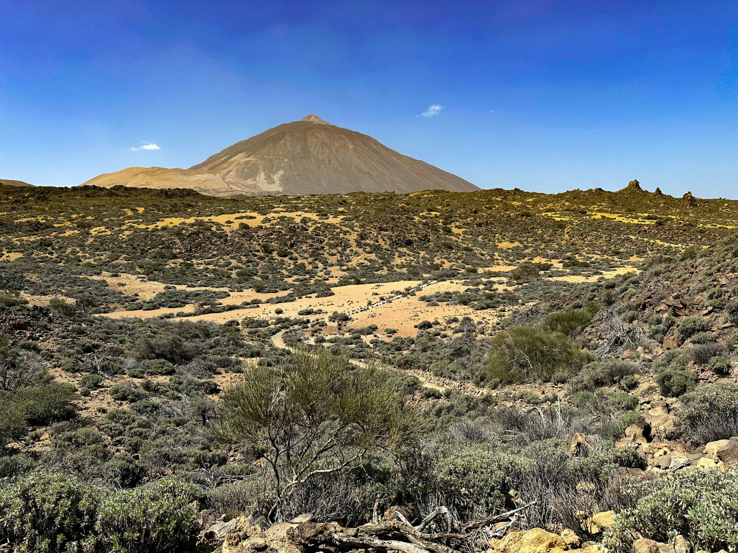
View from the hiking trail GR 131 to the Teide
Then it turns into forest. The path always descends parallel to the Barranco and the volcano El Alto de Guamaso. After a while you will reach the TF-24, which you cross through a tunnel. The trail continues downhill. At a fork, the GR 131 turns right to continue along the edge of the barranco. However, you now keep straight ahead on a forest path.
Hiking trail GR-131 in the upper part below El Alto de Guamasa down to Aguamansa
Route section junction GR 131 to serpentine TF-21
After a while, the forest path joins a larger forest path. Follow this to the left for a long time. The path goes up and down through the forest for quite a while. Finally you come to a crossroads. I actually wanted to follow the path straight on to make a really big turn. However, this was closed due to forest fire danger in March 2023. So I had to follow the path branching off to the left uphill. With the Montaña Roja on my right, I reached the TF-21 again after a while. Afterwards, I had to walk around to the right along the road for a while. I would have avoided this on the other path, which is also doable this way. But the nicer path is definitely the one straight ahead through the forest (if it is not closed).
Refuge choza de Scentenius at Pista Piedra de los Pastores near TF-21
Then, at the next opportunity, take the next path uphill that branches off to the left. This way you will have the Montaña Roja on your left and will reach the TF-21 on the Pista Piedra de los Pastores at the Choza de Sventenius refuge. From there, the hiking trail leads uphill after a few steps to the left along the TF-21 through the forest. After a short while, you will meet the TF-21 again. After a few metres to the left, you will leave it again uphill. At the next hairpin bend, you will again briefly meet the TF-21, which you then leave on the hiking trail to the right uphill through the forest.
Ascent path through the forest
Route section Serpentine TF-21 to El Portillo Starting point
The small trail now takes you uphill through the forest for a long time. Then you reach a sandy plateau covered with bushes. There I met a lot of lizards. They were happy to share their breakfast with me (see video). You walk straight ahead for a short while. Then you meet the main hiking trail between El Portillo and the Fortaleza. Turn right and walk downhill to the Fortaleza and at the next junction to Montaña Blanca. However, keep to the left and walk towards El Portillo with beautiful views of the Teide and the vast plateau on your left.
Main hiking trail between the Fortaleza and El Portillo
Eventually you will reach the Centro de Visitantes de El Portillo (Visitor Centre). Here you can admire the informative exhibitions and landscaped gardens. When you have seen or know everything, walk along the upper left path behind the Visitor Centre. At a certain height, you will come out of the Visitor Centre through a gate. The path then takes you back downhill towards the El Portillo road junction to the starting point of your hike.
Hiking trail behind the visitor centre in El Portillo down to the road junction
And finally
I hope you enjoyed this varied circular walk around El Alto de Guamaso volcano, followed by a loop around Montaña Roja and into El Portillo. If you look at the map, there are many forest paths in the forest area around the Montaña Roja, so you can adapt the hike to your own needs and wishes. Whatever you decide, I hope you enjoy all your hikes,
Dagmar from Siebeninseln
Thank you for reading!
If you've found my hiking guides on SiebenInseln helpful for your Canary Islands adventures, please consider leaving a small tip. Your support is greatly appreciated and helps cover the costs of maintaining this blog.