Montaña de las Arenas Negras – Montaña del Cerrillal – Montaña del Cemillar
I don’t want to confuse you with these names. But to be honest, I am still not sure whether the Montaña de las Arenas Negras is really called that or whether it has a different name. In some hiking apps it is called Montaña del Cerrillal and in one it is also called Montaña del Cemillar. The latter is probably a spelling mistake. According to the majority of my explorations, it should be Montaña del Cerrillal. But I decided to follow the designation of the paths in the official Teide National Park folder and the Rother hiking guide.
Map

View back from the lower hiking trail to the Montaña de las Arenas Negras
In both, this volcano is called Montaña de las Arenas Negras. Yes, I know that the Montaña Negra volcano on Tenerife is also sometimes called Montaña Arenas Negras. But since you’re actually trudging through black sand (arenas negras) for a long stretch on this hike, I think this name is simply appropriate. If anyone knows better, please forgive me. But whether you call the interesting black volcano Montaña Arenas Negras or Montaña del Cerrillal, the leisurely hike does not lose its charm. 
On hikes in May and June, you will discover many Tajinasten on the approach and on the trail
Hike Montaña de las Arenas Negras
On this small, contemplative round tour in the Cañadas del Teide near El Portillo, you hike once around the Montaña de las Arenas Negras. You hike on excellent hiking trails and can enjoy beautiful views of the Teide and the Cañadas. If you hike this trail in May or June, you will be able to see the big red impressive endemic Tajinasten around you. You can read more about the Tajinaste here. 
Tajinaste by the wayside
extended this little round trip a bit, as I wanted to go up to the high trail of the Siete Cañadas hike over the Cumbre of Tenerife. As the hike is quite short, you can do this as well or just leave it at the round tour. If you do the Siete Cañadas hike over the Cumbre, the outward route of this short circular hike can be your return route. 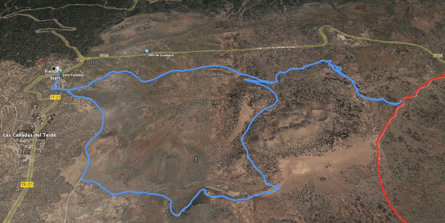
Montaña de las Arenas Negras Hike Track
General information about the hike Montaña de las Arenas Negras
Starting point and access
The starting point of the hike is the National Park Visitor Centre (Centro de Visitantes) on the TF-21 about 400 metres from the El Portillo road junction at 2053 metres altitude.
Access by car
You come from the north on the TF-21 or TF-24, which meet in El Portillo. From there it is only 400 metres on the TF-21 to the Centro de Visitantes. There is ample parking at the visitor centre.
Access by bus
Twice a day, the Titsa bus lines 342 (Costa Adeje – El Portillo) and 348 (Puerto de la Cruz – Parador Nacional) run along this route and stop at the Visitor Centre in El Portillo. For more information and exact times, visit the Titsa website. Article summary and large selection of GPS hiking tracks
Sign up for my newsletter now and get exclusive access to my collected GPS tracks as well as all the brief information about my articles.
Sign up nowTime
I don’t like to give general times for hiking tours, because the times are very individual. I needed about 3 hours for this short round with a detour to the high trail.
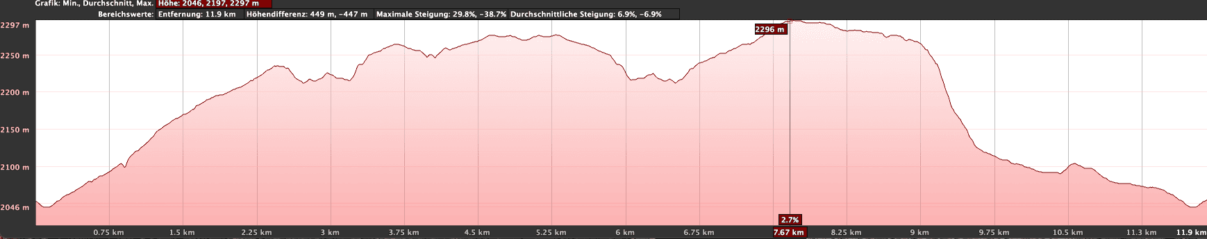
Altitude profile of the hike Montaña de las Arenas Negras
Difference in altitude and distance
The difference in altitude is just under 500 metres to the high-altitude trail and 350 metres if you only do the round tour. The route is 13 kilometres long with the high trail and just under 11 kilometres long as a circular route.
Requirements
You hike the entire time on good, excellent hiking trails. The connecting trail to the trail Siete Cañadas is apparently not used very often, so it is a little difficult to find in some places. The paths of the round tour, on the other hand, are very well marked and signposted and cannot be missed.
Refreshments
You will find refreshment stops near the starting point in El Portillo. However, please take enough water with you for the hike.
Variants
If you wish, you can combine this hike – if it is not too much at once – with the Siete Cañadas hike, as part of this hike can be the return route of the Siete Cañadas hike anyway. You can also hike from El Portillo to Fortaleza or Montaña Blanca. Another hike around the volcano El Alto de Guamaso starts in El Portillo and can be combined very well with this hike. 
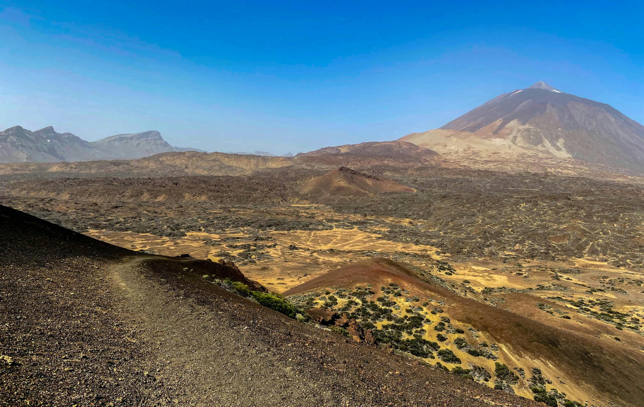
View from the ascent path Montaña de las Arenas Negras to Teide and the Cañadas
Hike Montaña de las Arenas Negras
Route section Visitor Centre at El Portillo to junction S-37 from trail S-2
You start your hike at the visitor centre above El Portillo. Across the road, behind a barrier, is the start of the Sendero 4 trail, which you follow for a short distance (860 metres). You will then come to a fork in the road. You will come back to the right on the S-4 trail. Now, however, go around to the left and follow the S-2 signposted Cerrillar – Carnicerial. You will only be walking on the trail for a short time. At the point where the track bends to the right with a chain barrier, leave it and walk straight ahead.

Starting point for the circular hike Montaña de las Arenas Negras
You cross a small gully. Afterwards, the path goes comfortably up the slope while you enjoy views of the Guamaso volcano and the Teide. At the point where the ascent to Montaña de las Arenas Negras begins in wide serpentines, I left the hiking trail straight ahead onto hiking trail S-37 to make another small excursion to the heights. If you don’t want to make this little detour, you can just continue straight ahead at this point. I will come back to this point later.
Article summary and large selection of GPS hiking tracks
Sign up for my newsletter now and get exclusive access to my collected GPS tracks as well as all the brief information about my articles.
Sign up now
Sendero 37 - junction from trail S-2 towards the Siete Cañadas hike on Cumbre
Route section junction S-37 from trail S-2 – detour to the trail over the Cumbre
If you follow the small detour, you continue to climb through the hilly mountain landscape parallel to the TF-24 Carretera de Esperanza. You will walk through small valleys and from time to time you will have to look very carefully to see where the path actually runs. But if you look carefully, you will always be able to pick it up again. Eventually you will reach a small gorge.

Hiking trail through a rather barren volcanic landscape to the high trail Siete Cañadas
Walk uphill through it to the right. Scrubland alternates with barren sandy areas. At the top you walk straight ahead with beautiful views. Then the path leads you downhill to the right through a small valley to a main path. This is the path that goes over the Cumbre de la Cañadas to the TF-24 (Siete Cañadas). On the left, you will soon reach the TF-24, and on the right, the Cumbre. But I went back to the circular route from here. 
View from the Montaña de las Arenas Negras Saddle to Teide
Route section junction S-37 from trail S-2 to Arenas Negras
Whether you followed me up the small extension or not, now the hike continues on the S-2. In a big serpentine you reach the saddle between the Montaña de las Arenas Negras (2347 metres) on your right and the Montaña de Maja (2365 metres) on your left. From up here you can enjoy magnificent views. A little later you will see a large sandy area (Llano de Maja) on your left.

Descent trail S-2 of the hike Montaña de las Arenas Negras - here at the post the trail turns right
There is a post here and rows of stones mark the main path, which you now follow to the right. You walk along the upper edge of a small valley. From here you can enjoy the Montaña de las Arenas Negras as well as other views. Finally, you reach the end of the ridge. There you will actually stand in front of the Arenas Negras, the black sandy lava slopes.

View from the descent path down into the gorge and over to the visitor centre and El Portillo - in the background the Fortaleza
Route section Arenas Negras to starting point Visitor Centre
From here follows a steep serpentine descent down the lava slope. In the deep black sand, a descent of a special kind. Then the path turns right and, after a short time, takes you around to the right onto another black lava path. You now walk downhill for a long time. Finally, you will come back to the Sendero 4 trail, also known as Siete Cañadas. It runs along the foot of the Cumbre to the Parador, while the hiking trail (also called Siete Cañadas or El Filo) runs across the Cumbre. 
Steep descent on the black sand on the S-2 down to the main trail Siete Cañadas S-4
Therefore, Sendero 4 takes you left to the Parador and right back towards the Visitor Centre. On the wide path you walk along the large wall Riscos de las Ventanas. After a while you will come to the junction where you previously turned off onto Sendero 2. Now go straight on. And shortly afterwards you are back at the starting point, the visitor centre above El Portillo.

Point where the S-2 meets the Siete Cañadas trail.
And Finally
I hope you enjoy this short circular walk on black volcanic sand in the Cañadas. It is indeed a small circular walk for connoisseurs, where you can relax and simply enjoy the landscape. If you’re looking for more of a challenge, you’ll find plenty of trails nearby to extend this hike. The pictures are a little hazy as there was a strong Calima over the island at the time I did the walk. If I am there again, I will take new photos and share them. I hope that I was able to give you a good impression of the hike and I wish you a lot of fun on all your hikes,
Dagmar from Siebeninseln