Great views from above Ifonche
This great circular hike high above Ifonche leads you – at least you feel it – into the wilderness. When I made the admittedly quite large hike, it became an experience of a special kind. On the one hand, there were so many paths and branches on the way that I simply had to try out some of them. As you can easily see from the track, I made some „extra trips“ from the basic route.
Map

View to Ifonche from the Roque de los Brezos
On the other hand, we actually only met a small group of three other hikers during the whole day. So this trail is really not one of the best known routes on the island. But it leads you high above the small village Ifonche into the wide lonely pine forests at the foothills of the Cañadas.

View of Ifonche from the heights
And you have the possibility to try different ways through lonely gorges and over remote mountain ridges. A tour under the motto „Who seeks solitude“. Another tour of this kind I had described in the Barranco Natero. On this hike you will partly meet well laid out hiking trails. And then it can be from time to time also that it becomes really difficult to find the path. You can see from my track that I have also searched to the right and left of the path for further possibilities and routes. This is therefore a walking tour for explorers. 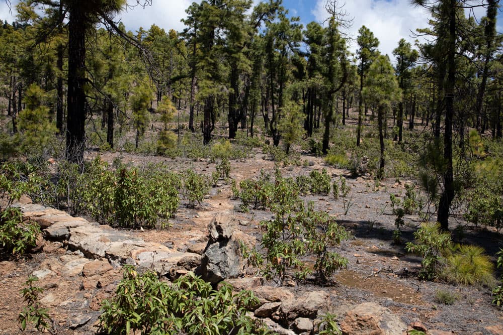
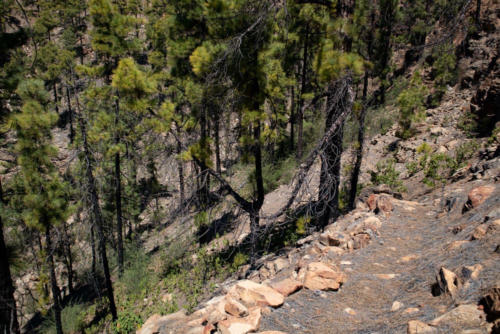
Covered water channels on the Ifonche Circular
Ifonche, mountains and gorges
The small village of Ifonche lies at an altitude of 1040 metres in the southwest of Tenerife, far above the district town of Arona. The inhabitants live mainly from agriculture. There is a bar and a restaurant right at the starting point of the hike. Ifonche is a real hiking junction and therefore popular with hikers. Nearby are the Roque Imoque and the Roque de los Brezos. You can find the corresponding circular hike here. From Ifonche you can also go to Adeje . 
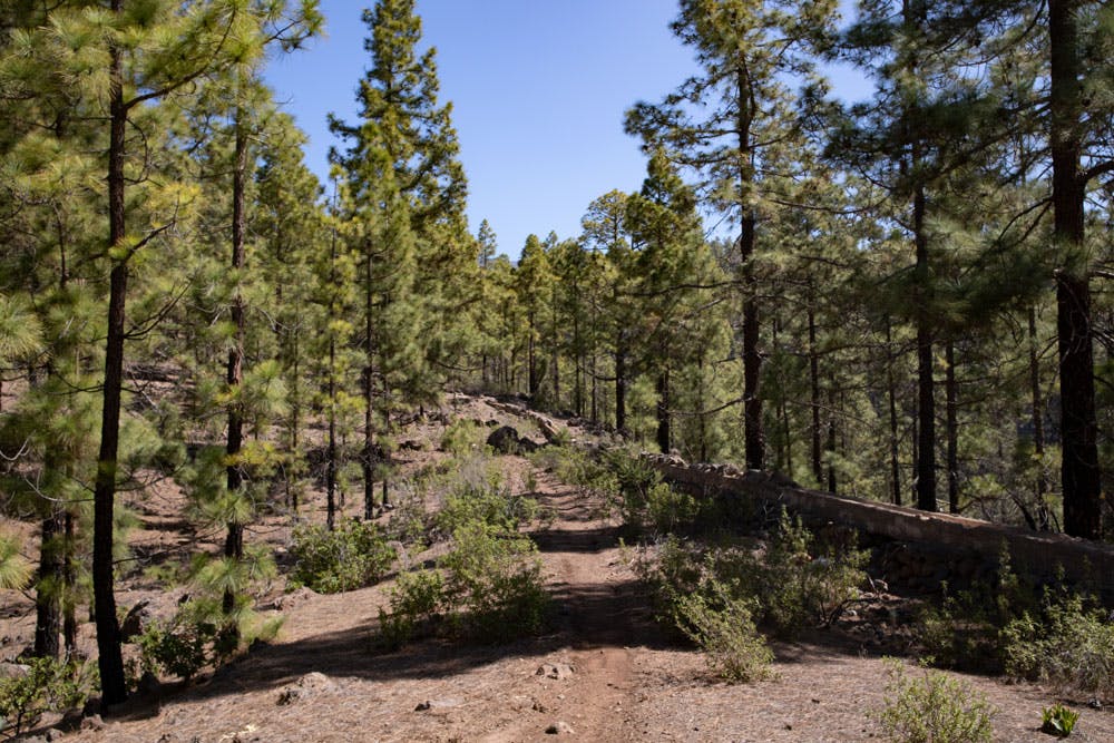
view over the pine forests
If you only want to go for short walks, you can hike into the nearby Barranco del Rey or look into the mighty Barranco del Infierno. Paragliders also use the area around Ifonche for their excursions in the sky. Finally, you can walk from Ifonche to Vilaflor (starting point of Paisaje Lunar). But the hike presented here takes you up into the lonely wooded slopes below the Cañadas. 
Track Ifonche Circular
General information on the Ifonche circular hike
Starting point and approach
The starting point of the big circular walk is the restaurant El Dornajo in Ifonche.
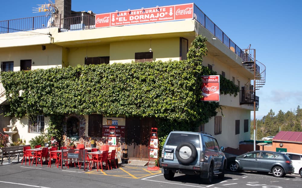
Starting point Restaurant El Dornajo
Arrival by car
You leave the TF-1 motorway in the south at the Arona exit. On the TF-51, continue through Arona in the direction of Vilaflor. At La Escalona turn left/straight onto the TF-567. Continue straight on until the (almost) end of the road. There you stand in front of the restaurant El Dornajo. From the north, take the TF-51 via Vilaflor to La Escalona. There are plenty of parking spaces in front of the restaurant and on the street.
Arrival by bus
From Adeje there is the Titsa bus line 342 to El Portillo. This bus also stops in Ifonche. Details can be found on the Titsa homepage. Article summary and large selection of GPS hiking tracks
Sign up for my newsletter now and get exclusive access to my collected GPS tracks as well as all the brief information about my articles.
Sign up nowTime
I don’t like to give general time information for hiking tours, because the times are very individual. For this big round trip we needed almost 8 hours with extensive breaks. But you can do it much faster, because I went some additional ways here to explore it (more details in the description).
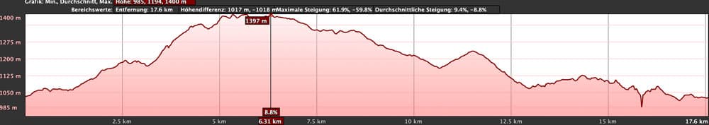
elevation profile Circular Ifonche
Difference in altitude and distance
The difference in altitude is with up and down about 780 meters. Also the height can be reduced considerably by abbreviations. The distance is about 18 kilometres. Also here you can save approx. 5 kilometres by abbreviations.
Requirement
Basically it is a medium hike, but it requires more than just a little stamina. The tour often runs along good hiking and driving paths. In between, however, there are also narrow and hard to find paths from time to time.
Refreshment
Only at the starting point there is a bar/restaurant El Dornajo. Therefore bring enough water and food for the long hike.

Track circular straight Ifonche (orange) and blue the track from Adeje to Ifonche
Variants
This tour can be combined well with various other hiking and circular walks in the vicinity. So there is the round tour around the Roque Imoque and to the Roque de los Brezos. A part of the way back is identical with the hike from Adeje to Ifonche. From this hike you will also look into the Barranco del Infierno. This big tour can be reduced in length and height if you don’t follow my „extensions“ and if necessary even run the abbreviations given here. The orange marked tour is the „pure“ route with abbreviations. Of course, you can also extend the tour by extending the lap on my „special paths“.

hiking path through the shady forest
Circular hike above Ifonche
El Dornajo Restaurant section to Barranco junction
You start your hike in front of the restaurant El Dornajo in Ifonche. There you will find a signposted hiking trail next to the hiking board in the direction of Vilaflor (GR-131). Follow this initially wide path through fields and uphill past two buildings. After a short while, two paths turn right downhill towards Vilaflor. You can see that I walked along them a little to see where they lead. From the second path I made a wide arc up to the finca.

junction hiking path to Vilaflor
You can have it easier and shorten it by simply following the road until you reach the small finca on the mountain. The wide road ends at the finca. And behind the finca a narrow path leads uphill. You follow this path. The path leads you uphill through woods on a ridge. Follow this path uphill for a while. Finally it changes to the left side of the slope and brings you into a Barranco. At the end of the Barranco a path leads uphill again on the opposite side. However, you continue straight ahead in the Baranco bed.

View from the slopes to the backend of the Cañadas
Section Barranco crossroads to ridge junction through the valley
Article summary and large selection of GPS hiking tracks
Sign up for my newsletter now and get exclusive access to my collected GPS tracks as well as all the brief information about my articles.
Sign up nowAs you can see from my track, I first followed the main path and then looked at the terrain and the paths on the opposite Barranco side. You can also save yourself this section by simply climbing straight up in the Barranco bed. This path is a bit hard to find as it branches off to the right of the main path. Just follow the course of the gorge. It gets narrower and steeper on the sides.
The path leads along the left side of the mountain for a while. Then you come to a spot where steep rock faces rise in front of you. Here you cross the Barranco and climb steeply up a narrow path on the right side. Now you are back on a ridge. From this ridge you have a wonderful view back over Ifonche and the surrounding landscape. You continue uphill on a path between the trees on the ridge. At the end of the ridge the path turns left in a wide arc through the valley.

drive way down the forests direction Adeje
Route section ridge junction through the valley to the larger driveway
As you can see from the blue track, I have chosen a path down to the left that leads to a water pipe. I wanted to see if there was a shortcut at this point. Apparently at this point the lap can be shortened a lot if you follow the path straight down. But then I returned to the original upper path. Shortly afterwards I left the path again to the right to see if I could find the path leading up to the Cañadas. Therefore at this point please be careful with the track.
You just keep straight on on the main path without going uphill on the right or downhill on the left. The trail runs gently up and down the wooded slopes. Finally you reach a mountain ridge. There one path branches off to the left and another to the right. But you go down a narrow path into the Barranco. Then you cross the Barranco Grund and slowly go up again on the other side of the slope. Finally, the trail takes you to a larger road, which you continue left.

pine forests and barrancos on the way
Section forest road to Lomo de las Lajas
This road takes you high above Taucho downhill for quite a while. In the distance you can see Ifonche lying after a while. And now it gets a bit complicated. At a fork you can go left or right. We first went left and finally came to a break-off edge. According to the track a steep path should lead down here. This would shorten the lap considerably. But we didn’t find it.
So we had to go back uphill a bit and then follow the road to the right. So you can try to find the shortcut yourself or go right downhill through the forest. The footpath will take you to a crossroads – Lomo de las Lajas. From here, the PR TF-71 trail also runs from Adeje to Ifonche. On the right side there is a footpath to La Quinta.

Hiker on the Circular Walk Ifonche
Section Lomo de las Lajas to the little hill close to Ifonche
However, you tend to keep right towards the pine forest. From now on you follow the path through the pine forest on the edge of the Barranco de la Fuente. The path takes you up and down in a wide arc around the Barranco de la Fuente. The shortcut comes from the left onto the main path. At the end of the western Barranco side, the path descends into the Barranco Grund. There you change to the other side and walk uphill again.
The path then leads you along the eastern side of the Barranco with magnificent views of the gorge that slopes deep below you. You will cross some more Barrancos until Ifonche. Each time you will have impressive views into the depths and partly to the south coast. Especially impressive is the hiking trail in and around the Barranco Seco, into which you hike deep. Only then can you cross it. But then after some time you will see Ifonche lying behind a hilltop.

ridge on the Circular Ifonche
Section little hill to Restaurant El Dornajo in Ifonche
In front of you you can now see terraced areas and individual farmsteads. The path leads downhill through the slope. Then a main path crosses which is marked with a crossed out cross on the right. To the right of the crossroads you can see a large farm. If you follow the path to the farm, you are not only on the alternative path to Adeje, but you can also take a look from above below the farm into the Barranco del Infierno.
But the tour to Ifonche follows the path straight ahead. It runs below terraced fields. Then it goes slightly up again through a pine forest. After coming out of the forest, the path merges with another path coming from the left. Follow the path to the right. After a short time the path leads into a road where you turn left. In front of you at the top you can already see your destination: the restaurant El Dornajo in Ifonche.
hiking path out of the Barranco to the ridge
And finally
On this hike, which rather reminds of a small excursion into the wilderness, I hesitated to publish it here. As you can easily see on the track and the time, we often deviated from the actual circuit. For me it was nice to explore the surrounding paths and areas. But the track is only suitable for hiking to a limited extent. Therefore I tried to give an exact description of the hiking tour. I hope that you will still be able to follow this hike and maybe even discover your own routes. I wish you a lot of fun while hiking,
Dagmar von SiebenInseln