Los Carrizales is a small village in the Teno Mountains, not far from the famous village of Masca. It is a hamlet in the municipality of Buenavista del Norte, in the north of Tenerife.
Map
View from the edge of the cliff to the cliffs and the Atlantic Ocean
There are two districts, Los Carrizales Bajo and Los Carrizales Alto – one lower and one higher. Both districts are located at the upper end of the gorge of the same name at an altitude of up to 600 metres above sea level.
View on Los Carrizales Alto
Although the Barranco of Los Carrizales is not as well known as the nearby Masca Gorge, it is always worth a hike because of its wild nature. Today, however, we take the high-level path over the Barranco di Carrizales, also known as the Abache Steig. This climb is already impressive to look at because of the rugged rock walls on the sides. And from up there you have dizzying views into the two steep gorges on each side of the path.
Finca at the ridge of Los Carrizales
Similar to the famous Guergues Steig hike, the path along the Steig of Los Carrizales will take you past an abandoned finca with an old threshing floor. At the end of the hike, you can then take a look at the Atlantic Ocean directly below you from the height of the abort edge.
Track hike over the Carrizal ridge (Abache Steig)
But there is another alternative. If you don’t want to take the circular route at the finca, you can also descend further from there and hike over a second threshing floor to the extreme edge of the Abache Steig. An impressive tour, but one that requires surefootedness and a head for heights.
Track of the HIke Abache Steig down to Viewpoint Los Gigantes
General information about the hike over the Abache Steig from Los Carrizales
Starting point and approach
The starting point is a small square on the road to Los Carrizales (Calle Carrizal Alto). In the first bend after turning off the TF-436 you can park your car on the left side. This is also where the hike starts.
Starting point - bend at the street to Los Carrizales Alto
Arrival by car
From the north on the TF-436 from Buenavista del Norte and from the south on the TF-436 from Santiago del Teide, take the car to the exit for Los Carrizales. The starting point of the hike is already in the first wide bend down into the village.
Arrival by bus
The Titsa bus line 355 runs between Santiago del Teide and Buenavista del Norte. If you get off at TF-436 at the entrance to Los Carrizales, you can easily walk the short distance to the starting point. More information can be found on the Titsa Homepage.
Time
I don’t like to give general times for hiking tours, because the times are very individual. Here I only needed a little over an hour as pure hiking time. But on the round tour I was on the move for over 3 hours. This was due to the fantastic views, which repeatedly invited me to stop and take photo breaks. For the tour to the Los Gigantes viewpoint, we needed just under 4.5 hours, including the way there and back.
elevation profile Carrizal Ridge (Abache Steig)
Difference in altitude and distance
The pure height difference of this hike on the climb of Los Carrizales is only about 180 meters. But through a lot of ups and downs, the total altitude difference is almost 330 meters. According to the altitude profile, the route is a little over 5 kilometres long. My JPS has here some meters with the straight going up in narrow serpentines embezzled. Actually the distance is scarcely 7 kilometers long.
Article summary and large selection of GPS hiking tracks
Sign up for my newsletter now and get exclusive access to my collected GPS tracks as well as all the brief information about my articles.
Elevation profile of the hike over Los Carrizales down to the viewpoint of Los Gigantes
The route to the Los Gigantes viewpoint, on the other hand, has about 780 metres of altitude difference and is also just under 7 kilometres long.
Requirement
Both hikes are not very long. However, already on the circular hike, the path goes steeply along the precipice in parts, so that you should be sure-footed and have vertigo. The path down to the edge of the precipice can be described as difficult. It is often difficult to find the way on or the path. You hike close to the edge of the precipice and should be sure-footed and free from vertigo.
Refreshment
There are restaurants, bars and shops only in the nearby Masca and/or at the Cruz de Hilda in the proximity. Therefore take enough water and food with you.
path behind the Finca - it leads on further down the ridgeor you walk another path a little bit more on the left side above the finca
Variants
Both tours can be combined and also extended. They run over two different mountain ridges. Here you can switch back and forth between the ridges on different cross paths and thus combine or extend the tours.
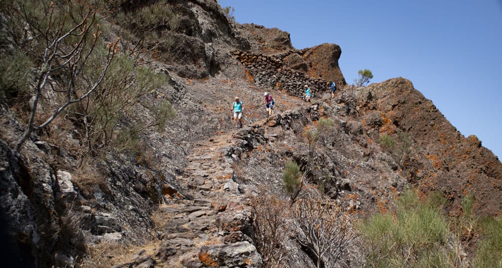
Hikers on the ridge of Los Carrizales (Abache Steig)
Hike over the Abache Steig from Los Carrizales
Section car park to hill on the mountain ridge near houses
Starting point - way to the rigde
You start your hike just below the TF-436 road that connects Buenavista del Norte and Santiago del Teide. The starting point is on the road to Carrizal Alto in the first bend. From there a partially cemented road leads you briefly downhill. Below begins the actual hiking trail, which takes you uphill in an arc to the right on the slope. You go up on the right side of the slope on a well laid out hiking path.
view point with a bench over Los Carrizales
After some time the path continues on the right side of the slope. But straight ahead a short steep path leads up to the mountain ridge. Here a small detour is worthwhile.
hiking path at the start of the hike to the Carrizal ridge
Because from up there you have a first really good view to the Barranco of Carrizal on one side and the Fortaleza de Masca on the other side. Up here there are fenced private properties, so that you can’t go on there. But the view is fantastic. At one place there is even a bench with a small table.
Hikers on the Abache Steig
Section of hill at houses up to the beginning of green bush land
You go down the small path until you reach the hiking trail again and follow the path on the right side of the slope. From here you don’t need a description anymore, because there is only one way. This often leads you very close to the abyss, but always in sufficient width along the path close to the ridge. It is possible that you might get into the clouds. But otherwise you can enjoy really wonderful views of the neighboring ridges of the Teno Mountains and the Barranco of Los Carrizal below you.
hiking path Carrizal Ridge (Abache Steig)
From time to time the path climbs quite steeply. The effort is always rewarded with an even better vantage point. You walk on narrow stone paths around some rock walls. It mostly goes up and down in an easy way. The steep climbs are present in between, but well feasible. If you have hiked a long time, the mountain ridge widens. Now you have exactly two runners in front of you. In between there is a large green area covered with bushes and grasses.
clouds over the Barranco of Los Carrizales
Section of green bushland to Finca and the second mountain ridge
The hiking trail now leads you on the left side of the ridge. On your right is a green area. Follow the path along the bushes for a while. Then you come to an abandoned finca with a threshing floor in front of it. How remote people lived here a long time ago. You can take a look at the abandoned finca. The circular walk across the valley between the ridges now leads you behind the abandoned finca down the path towards the green area and to the second mountain ridge.
Hiking trail close to the abyss
Article summary and large selection of GPS hiking tracks
Sign up for my newsletter now and get exclusive access to my collected GPS tracks as well as all the brief information about my articles.
But if you want to explore this first (main) ridge further, I describe below the way from here to the Los Gigantes viewpoint. The circular hike now leads you straight across the bush. If you wear long trousers, you have a clear advantage. The paths here are not so heavily used, so the branches of the bushes can leave some welts on bare legs.
clouds over the green between the ridges
Route section 2nd mountain ridge to the summit
When you have crossed the green area with the terraced fields and stone walls, the hiking trail takes you slowly up the 2nd ridge in an arc to the left. This ridge runs parallel to the first ridge. If you have a clear view at the edge of the gorge, you can now see the steep coast with the Atlantic Ocean deep below you. You walk along the left side of the ridge. From time to time there are fantastic views into the gorge deep below you. To your right you will reach a small summit on a small path after some time. It is well marked with a pole.
hiking trail and hikers at the ridge of Los Carrizales
This highest point of the 2nd ridge is ideal for a rest. You have beautiful views in all directions, provided that possible clouds allow it, of course. You will also find a small cave near the summit. From this point, the small circular hike goes back across the green space.
summit of the ridge Carrizal
But if you want to see and experience more, you can venture a little further along this ridge. You will come across a path that leads you down to the left into the valley between the ridges and then over to the other ridge.
Hiking path over the ridge
Route section summit to main hiking trail/return trail
From the summit you now go back for a short time on the same path that you came. When you reach the point where you crossed the green area, go straight on. You more or less always stay along the ridge. This allows you to enjoy wonderful views of the surroundings once again. After some time you will reach a larger rock massif.
Hiking trail and clouds at the ridge of Los Carrizales
You have to avoid that by bushes around its foot. The direction is clear for you, because you have to get back to the main path in front of you. Here in the upper part of the green area the way is not always easy to find. But if you keep to the right of the ridge, after a while you will see the main path in front of you again. You go around to the left. You already know the way back. Even if you look at the landscape from the other side, it looks different again.
At the edge of the cliff - Los Gigantes viewpoint on the right
Abache trail down to the Los Gigantes viewpoint
Trail section starting point to small break-off edge
If you want to go down to the Los Gigantes viewpoint, follow the directions above to the finca. At the finca, a path leads straight ahead. You can follow it and after a while, when it seems to end, change to another path on the left side of the slope. However, it is better to go up the slope to the left immediately at the finca and follow a small path always close to the edge of the cliff. Sometimes the path is not easy to find, as you can see from my track. We also walked back and forth a few times in some places.
Wanderer auf dem Abache Steig über dem 2. Dreschplatz
But the main direction is down parallel to the edge. Once I also walked further away from the edge down through the bush. That also works, but it is more difficult. After a while, you will see another threshing floor far below you. You have already passed the finca at the first threshing floor. The path, which is marked in parts with cairns, takes you steeply down towards this threshing floor. From time to time you will also walk without a path. At one point you will reach a steep drop-off close to the edge of the quarry, here you have to swerve a little to the right and hike down at the end of the quarry edge.
Behind the rock bar below the threshing floor
Small break-off edge to Los Gigantes lookout point
The closer you get to the threshing floor, the clearer the path becomes. Mostly it goes downhill over clear rock. The large threshing floor itself is right on the edge of the cliff and offers a magnificent view into the barranco on the other side of the Abache trail. Small shelters have also been carved into the rocks by people. From the threshing floor, continue straight ahead. After a while you will come to a large rock bar. If you can, you can climb over it. There is also a path close to the left along the edge of the cliff. There you can go around the ledge. It looks more dangerous than it actually is.
on the outer edge -Abache Steig
After passing the rock bar, continue straight ahead. Now comes the last small rise that takes you up to the Los Gigantes viewpoint on the left slope of the mountain. At the top, not only have you made it, but you can truly enjoy a fantastic view of the giants as far as Los Gigantes and also down into the neighbouring gorges. The mighty Abache Climb behind you also looks impressive. The right place for a rest. But then you still have a good climb ahead of you. If you like, you can choose the circular route on the way back.
View of the rock bar and the Abache Steig from below
And finally
I hope you have enjoyed these beautiful walks along the Los Carrizales path (Abache path). Whichever ridge or precipice you hike there, you will enjoy the views.
Have fun hiking
Dagmar from SiebenInseln
Thank you for reading!
If you've found my hiking guides on SiebenInseln helpful for your Canary Islands adventures, please consider leaving a small tip. Your support is greatly appreciated and helps cover the costs of maintaining this blog.
Thank you for your support!
SSL secured
Comments
Edmunds - 12/05/24, 09:12 AM
I started this walk from Mirador de Cherfe on the road from Santiago to Masca. I climbed up Risco Verde on what I would say is a pretty adventurous path. From Risco Verde I took the very well built panorama path all the way along the ridge until the descent to Los Carrizales (just past where the descent to Cruz Hilda is). I descended from the ridge and did this walk, taking in both Abache and Los Gigantes viewpoint and returned back to the road.
The walk to Abache cliff is pretty easy. I was suprised how much harder the walk down to the Los Gigantes viewpoint was. It is quite a lot of descent, and there is basically no path. It is not a hard place to route find because it is obvious where you are supposed to go, but still, pretty much no path.
If you time this correctly, there is a bus that will take you back to Mirador Cherfe. I didn’t time it correctly and would have had to wait for 1.5h, so with nothing to do I climbed back up the ridge, and descended on the other side towards the chocolate cake mountain and took the bus from there.
Total length 7h 33m, 19,0km, 1150m ascent, 1680m descent.