IMPORTANT - This path has been closed for some time (as of November 2022). There are said to be various places that have been washed away. The path is very narrow and loose there (see also comments). We strongly advise against using the path because of the danger of falling and falling rocks.
The Great Anaga Hike can be combined in many ways

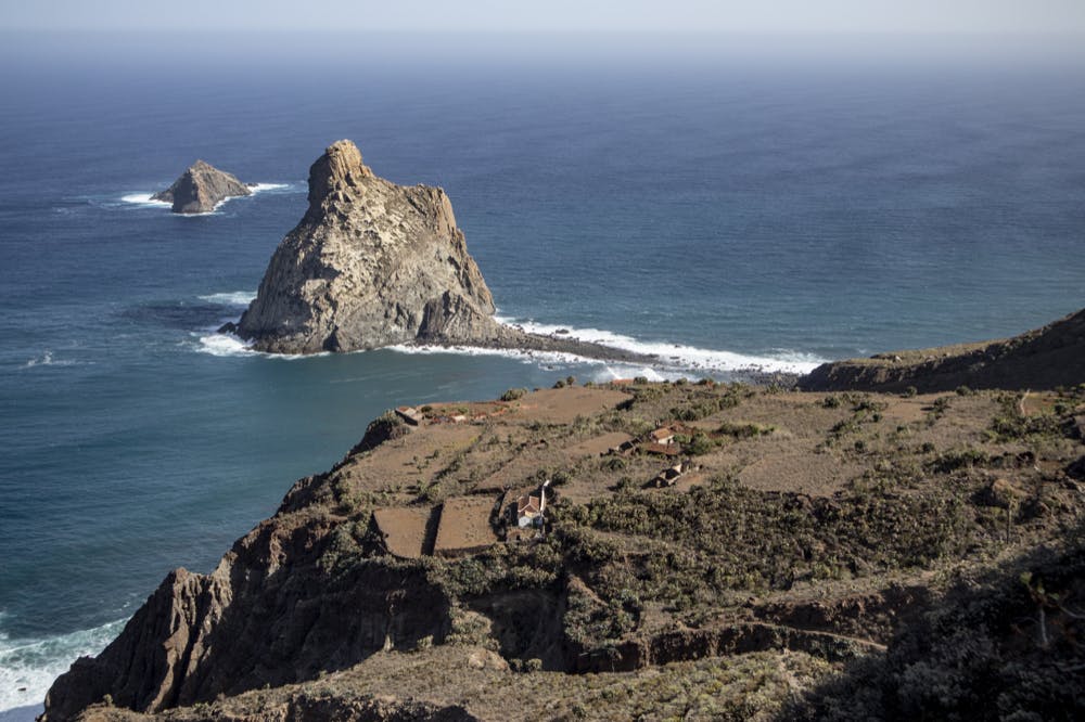
Hiking trail down to the lighthouse Faro de Anaga
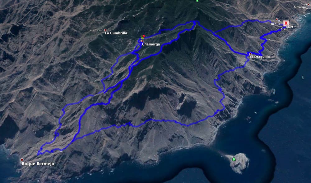
Today I finally present another Anaga hike. This big circular can be combined in many variations with other hikes in the vicinity. Up to now I have presented here on seven islands as hikes near Chamorga the Montaña Tafada Round and the hike from Chamorga to Roque Bermejo and over the lighthouse Faro de Anaga. Today’s Anaga hike can be perfectly combined with these two tours. Map

Old ruins on the wayside during the ascent towards Faro de Anaga
But this time the starting point of the Anaga hike is not Chamorga, but the hamlet of Benijo. But if you want to start in Chamorga or any other place, of course – as it is a circular hike – it can be done well. Today’s round can be extended with another round from Benijo via El Draguillo. I will present this little tour here soon.

Hiking trail in the hamlet of Las Palmas
Anaga hiking tour at the north east tip of Tenerife
The outermost tip of Tenerife is a very special place that at least I felt very far away from the touristical marked rest of the island. Already the approach over the Anaga high road to this part of the island is a special experience with the wonderful views at both sides of the ridge. From La Laguna there is only one access road TF-12, which leads over the ridge of the Anaga mountains. And when you then drive along the side roads on countless bends into the valleys, the world there sometimes seems a little more pristine and peaceful.

Anaga hike - View of Roque del Dentro
It is especially quiet in the area around the north-eastern tip of Tenerife. There you will find remote places that can only be reached on foot and sometimes by boat. There are deserted hamlets, a great nature and volcanic rocks off the coast. The right area for a really good Anaga hike. However, if you choose the big loop on this Anaga hike, you should be in good physical condition, as the up and downhill altitude difference should not be underestimated.
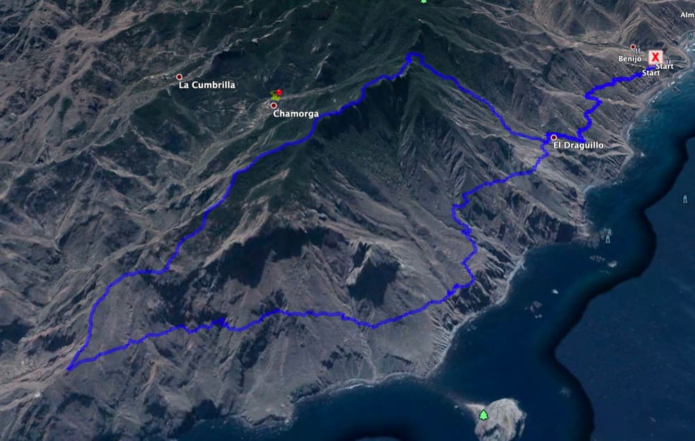
Great Anaga Hike - Track
General information about the Anaga Hike
Starting point and approac
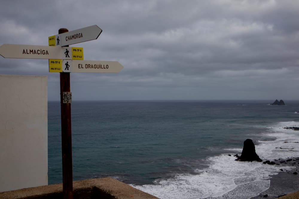
Hiking signs in Benijo to the TF 6, 6.1, 6.2
Starting point of this hike is the hamlet of Benijo on the TF-134 at the restaurant El Frontón.
Access by car
From the Anaga High Road TF-12, turn left onto the TF-134 and go down through the tunnel and then through the village to the coast. Follow the TF-134 further and further. Two kilometres past the village of Almáciga you will arrive in Benijo. Since many companies with day tourists visit this place, it can get a little crowded with parking lots from 10.00 am on. But around the restaurant El Frontón there are some parking places at the road. If one continues a little further on the hiking path in direction to El Draguillo, there is also a small plaza with some parking places before the further closing of the road.
Approach by bus
The Titsa bus line 946 goes via Tangañana to Benijo. You can find more information on the Titsa Homepage. Time
I don’t like to give general time information for hiking tours, because the times are very individual. We needed more than 6 hours for this tour – but with many breaks (my dog is slowly getting older and needs enough rest time in between).
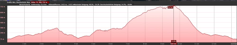
Elevation profile Great Anaga Hike
Article summary and large selection of GPS hiking tracks
Sign up for my newsletter now and get exclusive access to my collected GPS tracks as well as all the brief information about my articles.
Sign up nowDifference in altitude and distance
The difference in altitude is with many up and down about 1000 meters. The distance is almost 14 kilometres long. My height profile shows here basically a little less distance. But in the GPS it was clear that this Anaga hike is about 13.9 kilometers long.
Requirement
This Anaga hike is a strenuous tour, for which you need to be fit in any case. But for those for whom this is too exhausting, they can also walk only parts of it or choose a small tour over Benijo – El Draguillo, which I will introduce soon.
ATTENTION
For the coastal section between El Draguillo and the lighthouse Faro de Anaga you should be sure-footed and have a head for heights. Some parts of the path lead on narrow paths over scree fields or are actually very narrow directly at the abyss. Here there are also warning signs indicating rockfall and danger of slipping. Never walk on this path in rain or storm.
Refreshment
Refreshment stops are only possible at the start and end point Benijo. Therefore take enough water and if necessary food with you.
Track Great Anaga hike with related tracks
Variants
This tour can be easily combined with various other hiking and circular walks in the vicinity. For example, parts of the big Anaga hike lead over the Montaña Tafada route. Also the hike to Roque Bermejo through the Barranco of Chamorga to the lighthouse Faro de Anaga can be combined with this tour. If you want to extend the big Anaga hike a little bit and you are in good physical condition, you do not go up to Montaña Tafada but down to the lighthouse and return to Chamorga via the Barranco Bermejo. From there you can climb up to the pass Cruz del Draguillo (combination with the two above mentioned tours). If you prefer less, you can also simply walk from the hamlet of El Draguillo 2 kilometres along the coast to the deserted village of Las Palmas and back. You can also walk up from El Draguillo towards Chamorga and return to Benijo via an impressive pass and coastal path. I will present this tour here soon.

Anaga hike - hiking crossroads in El Draguillo
Great Anaga Hike
Section Benijo to El Draguillo
You start your hike in Benijo at the restaurant El Frontón or about 100 meters further along the road to El Draguillo. At the beginning you will find a hiking sign, on which the way to El Draguillo PR TF 6.2 is signposted. You will walk on the wide road, which is partly dirt road and partly concrete, from Benijo (78 m altitude difference) up to El Draguillo (180 m altitude difference). On the way you can already enjoy beautiful views of the wild surf, deserted beaches and steep gorges.

Hiking trail on the slope just behind El Draguillo
The path is closed for traffic (except residents). You will hike in wide serpentines slightly ascending to the small contemplative hamlet El Draguillo. El Draguillo lies on a ridge between two gorges. You hike across the ridge and come to a barranco at the end. There are hiking signs. On the right the path leads up to Chamorga. This is your way back. However, you continue straight on with the PR TF 6 over the wooden bridge that crosses the Barranco, towards Las Palmas (2 kilometres).

Anaga hike - View from the height to the hamlet Las Palmas
El Draguillo section to Las Palmas
From El Draguillo, the path leads you uphill on a good path. But after a short time the path leads over two scree fields. Warning signs indicate the danger of falling rocks and slipping. Here you should be sure-footed and free from giddiness. You have to be extremely concentrated, so that you should only enjoy the beautiful views standing up. After the scree fields the path remains narrow and leads you further up the mountain. You will pass several gorges.

Hiking trail along the coast above a barranco
When you have reached 300 meters of altitude, you can already see the almost deserted hamlet Las Palmas deep below you. Over a Barranco ridge the path now leads you down. In steep serpentines you descend deeply into a Barranco. You cross it and finally climb back up to Las Palmas on the opposite side. Here you are now back at approx. 80 metres altitude (as at the starting point of your hike). There are many abandoned houses and ruins as well as overgrown gardens that you can visit. The path leads directly past abandoned houses, gardens and fields. And you have a view of the impressive Roque de Dentro out in the sea.
Article summary and large selection of GPS hiking tracks
Sign up for my newsletter now and get exclusive access to my collected GPS tracks as well as all the brief information about my articles.
Sign up now
the hamlet of Las Palmas with many abandoned houses
Route section Las Palmas to Faro de Anaga (crossroads above)
The hiking path through Las Palmas is well marked (partly marked with yellow arrows or there are small signs with the inscription Faro). Through and shortly after Las Palmas it goes further downhill. But then the path climbs steadily again. At first you hike moderately uphill along the coast. But after a crossing of the Barranco it goes uphill in serpentines for a while. You pass an abandoned house and then walk around a Barranco to reach the next gorge over a small ridge.

Anaga hike - coastal hiking trail
After the steep ascent you will come to seven more gorges. One after the other you cross them on an easy ascent. You can enjoy beautiful views of the coast. After the sixth gorge, you can already see the upper part of the lighthouse Faro de Anaga in the distance. And then you finally reach a fork in the road at an altitude of about 20 metres. In a short time you will come down to the lighthouse on the left, from where you can climb up to Chamorga via Roque Bermejo and the Barranco. 
Hiking trail along the coast
Section Faro de Anaga to Casas Blancas
On this Anaga hike you now follow the PR TF 6.1 to the right uphill to Montaña Tafada. For quite a while you will be walking steeply uphill. The views of the Faro de Anaga, the coast and the Roque Bermejo are fantastic. This is the most strenuous part of the hike, but it follows good hiking trails. After having mastered the steep ridge path, the hiking path turns to the right. Now you can continue to ascend, enjoying magnificent views of the cliffs and the slopes below you.

Anaga hike - view of the lighthouse Faro de Anaga from the height
You will cross small pass roads and on the way on you will cross a small rocky plateau at the end of the ridge path. The path continues uphill. Towards the end of the path the trail finally leads you into the cloud forest. You walk through the forest for some time and at the end of the path you suddenly find yourself standing freely on the ridge path. On the left side you can walk further over the ridge (hike Montaña Tafada). However, this Anaga hike takes you around to the right. You hike over the ridge and after a short time you pass a hiking sign and a ruin (Casas Blancas). 
Crossroads of Chamorga, Montaña Tafada and lighthouse Faro de Anaga
Route section Casas Blancas to Cruz del Draguillo
Next to the ruins, the hiking trail leads left up the slope. After a short time you will come to a fork. The PR TF 6.1 turns left in the direction of Chamorga (see also the hiking trail Montaña Tafada). However, you keep right up the mountain. You are now at about 730 meters altitude. As you continue, the path takes you back into the forest. There it goes in an easy up and down for a while always along the ridge. On the left below you can now also see the village of Chamorga. 
Anaga hike - View from the height to the coast around Tangañana
Then you reach the crest height. There you can enjoy a beautiful view of the entire coast around Tangañana up to your coastal hiking trail. Deep below you will see the hamlet of Las Palmas, whose houses are not even the size of toy houses anymore. Up here you can take a break and enjoy the beautiful views. Then it slowly goes downhill again. After a short time you reach a pass in the cloud forest. This is the hiking crossroad Cruz del Draguillo.

Cruz del Draguillo
Section Cruz del Draguillo to Benijo
To the left, we descend at Cruz del Draguillo to Chamorga (see hike Montaña Tafada). Straight ahead you will come to a beautiful crest high trail, for which a permit is required in the further course of the walk. You go down to the right towards El Draguillo. First you descend in steep serpentines through the cloud forest. Quickly you lose height. Then the path takes you out of the forest, but continues downhill in small steep serpentines.

View down to El Draguillo
Below you can already see El Draguillo approaching. Meeting a junction, keep going straight downhill towards El Draguillo. But you can also turn left to Benijo in an extension of the hike. I will describe this little hike here soon. Finally you will come out shortly after the Barranco Bridge at the crossroads in El Draguillo. Now your round hike is finished. Downhill it goes in approx. 20 minutes now on the road back to Benijo.
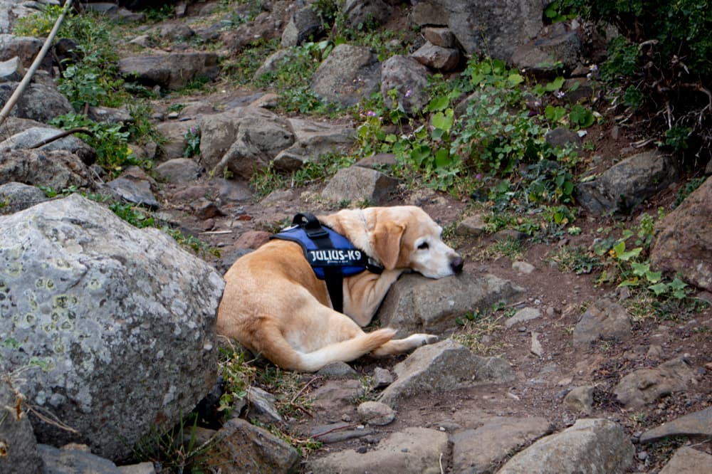
Hiking dog Lasko
And at the end
I hope you enjoyed this Anaga hike. Since it is directly adjacent to other circular walks (see above), you can combine them in any way you like. In any case, I wish you lots of fun on all your hikes,
Dagmar von SiebenInseln