Teno Alto – a small hamlet in the northern Teno Mountains with countless hiking options
The small mountain hamlet of Teno Alto is also called Los Bailaderos. It lies isolated on a plateau in the northern Teno Mountains, connected to civilisation only by a small winding road. Here it is still really quiet and tranquil. A retreat for anyone seeking peace and quiet. There are less than 100 inhabitants in Teno Alto. Due to the remoteness of the place, many old Canarian customs have survived.
Map

View of fields and terraces near Teno Alto
And you can still find natural Canarian country life in Teno Alto and the surrounding area. In addition to many goats and other animals, there are even some old brick kilns and threshing floors to admire in Teno Alto. You will also see traditional houses with walls made of the reddish rock that you will walk over during your hikes around Teno Alto.

View down to the north coast and over to the Risco climb
Teno Alto is a true El Dorado for hiking enthusiasts, with many trails running from the town in all directions. As the area around Teno Alto has a unique landscape, you will of course find many wonderful hiking possibilities. Everyone will find something to suit their needs and level of difficulty. The green highlands around Teno Alto evoke associations with Ireland. There are the steep slopes to the north and northwest coast with unique views. And then you can experience the ground shimmering in all yellow and red colours. It is particularly beautiful to see or photograph at sunrise and sunset. Teno Alto is indeed always worth a hike.

Hiking trail along the rock face
Hikes around Teno Alto
I have already described the high-altitude hike over the Baracán to Teno Alto and the circular hike over the Risco trail down towards Punta Teno on Seven Islands. And there are still quite a few hikes in this area waiting to be published. Unfortunately, there is so much work involved in a single small article on Seven Islands that I only get around to writing up a new hike every few weeks. But today it is finally time again. I’m describing a hike that is a bit „wild“ in parts, which begins on the coastal road and then leads on steep, impassable paths to the heights of the northern Teno Mountains in the direction of Teno Alto. 
Hiking trail over rocks and through the cloud forest below Teno Alto
This first part of the hike is really not suitable for everyone. A good head for heights and surefootedness are a prerequisite on the partly exposed paths. On the plateau around Teno Alto, the pace is more relaxed. You hike to Teno Alto on quiet hiking trails and can take a leisurely look at the small hamlet. Afterwards, you can take a trip over sandy and rocky dunes to the edge of the cliff. From there you will overlook the entire north coast and enjoy magnificent views. Finally, you will return to the starting point on the north coast via the well-known Risco Climb (LINK) with fascinating views.
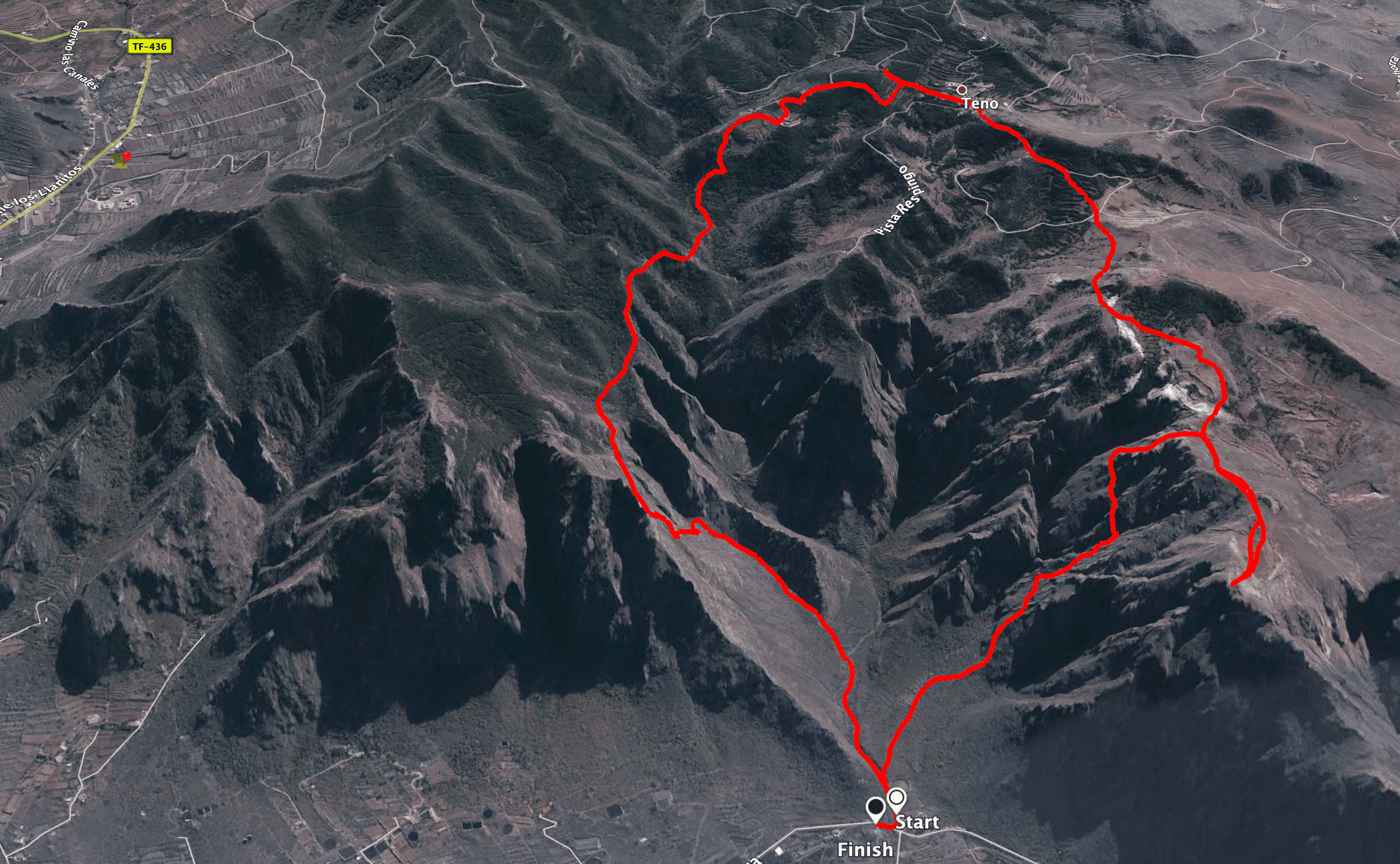
Teno Alto - Risco Climb Circuit Track
General information about the circular walk around Teno Alto
Starting point and directions
The starting point of this hike is the road Carretera Casablanca TF- 445 (Km 2.5) – not to be missed, as from here on the road is closed with a barrier. Parking is available at the side of the road.
Getting there by car
You drive from Buenavista del Norte on the TF-445 towards Punta de Teno until you reach the roadblock at kilometre 2.5.
Getting there by bus
The Titsa bus line 369 runs back and forth between Buenavista del Norte and Punta de Teno at a special fare of €1 (as of July 2021). Otherwise, you can also get there by taxi from nearby Buenavista del Norte. To find out how to get to Buenavista del Norte by bus (line 107, 355, 363, 365, 366), visit the Titsa homepage . 
View from the cliff edge over the north coast of Tenerife
Article summary and large selection of GPS hiking tracks
Sign up for my newsletter now and get exclusive access to my collected GPS tracks as well as all the brief information about my articles.
Sign up nowTime:
I don’t like to give general times for hiking tours, as the times are very individual. We needed about 5.5 hours for this big round hike with a stay in Teno Alto and a detour to the edge of the cliff.
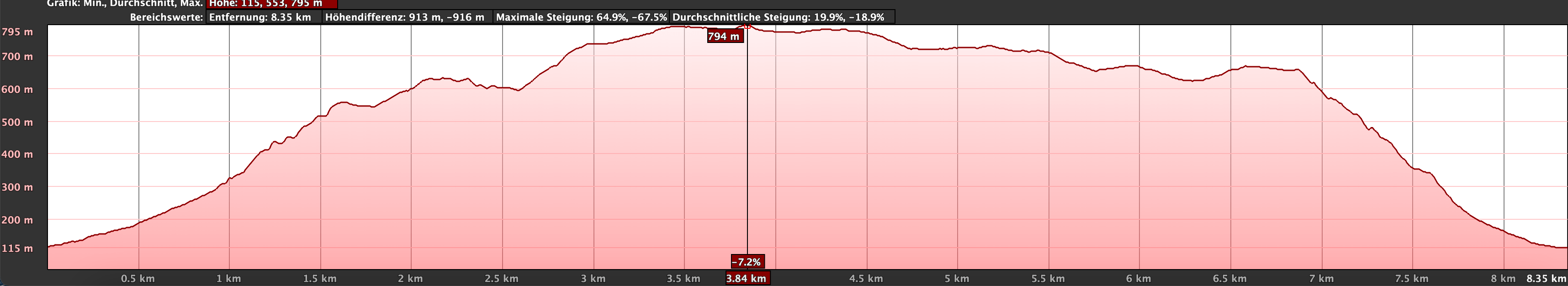
Altitude profile of the Teno Alto - Risco climb
Difference in altitude and distance
On the entire hike you have just under 900 metres of ascent. The route is just under 9 kilometres long.
Requirements
The first part of this hike is really not suitable for everyone. It goes steeply up the slopes of the northern Teno Mountains over impassable paths. A good head for heights and surefootedness are required. And often the path is difficult to spot. The middle part around Teno Alto, on the other hand, is more like an interesting walk on a scenic plateau. The descent via the Risco Steig is steep – it is a normal hiking trail – but otherwise easily manageable.
Refreshments
There are small bars – if open – in Teno Alto. However, you should definitely take enough water and, if necessary, food with you on the way.
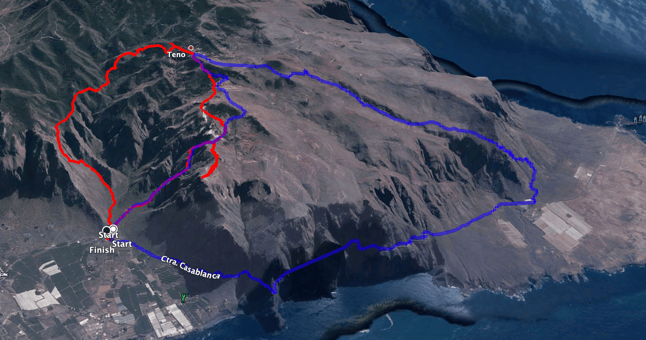
Tracks of the round trips around Teno Alto (blue: Risco trail with direction Punta Teno, red: Teno Alto with Risco trail)
Variants
This tour can be combined with many other hikes and circular walks in the vicinity of Teno Alto.
But before I get to that, you can of course also design this large circular tour yourself. If it is too long for you, you can leave out the detour to the edge of the cliff. But in case that you only want a very short hike, you can also drive to Teno Alto by car and take the walk from the village of Teno Alto to the edge of the cliff. If the first part of the hike is too hard or too rough for you, you can of course go up and down the Risco trail. Or you can do the round trip via the Risco climb in the direction of Punta Teno and return to the starting point on the road. If you want to hike in the other direction and perhaps climb the Baracán, you can do this large circular hike. In addition to these variants, there are many more interesting hikes around Teno Alto, Punta Teno and the Risco Climb, which I hope to present here soon.

Hiking trail to the break-off edge high above the north coast
Circular Hike Teno Alto – Risco Climb
Route section TF 445 KM 2.5 to ascent Barranco de Bujame
You start this hike at the TF-445 road, where there is a large hiking sign. First, follow the PR TF 58 trail on the broad path past a large water reservoir. After a very short time, a path branches off to the right of the barranco, up into the Barranco de la Torre. This is your way back. Here you will come down from the Risco climb. However, you continue straight ahead in the barranco and move towards the foot of the left side of the slope. As there is only the path through the barranco at first and occasionally narrow paths on the side, it is better and safer to walk with GPS track here.

Galería by the wayside
After a while you will come to a fork. The main path continues straight ahead in the barranco. But you go uphill to the left, following a narrow path on the left edge of the Barranco de Bujame. You will see a Galería at the top and also find an old furnished cave on the side of the path. You pass old railroad tracks and trolleys. At the Galería you climb up a slope. Afterwards, the path above the Galería climbs very steeply up the rocky slope. You need to be absolutely free of vertigo for the upcoming difficult section. The path goes steeply downhill beside and behind you. The path takes you directly up the rock face. From time to time you climb over protruding rocks and can enjoy exhilarating distant and deep views.

Hike on steep impassable paths - ascent to Teno Alto
Ascent section Barranco de Bujame to ruined houses
Article summary and large selection of GPS hiking tracks
Sign up for my newsletter now and get exclusive access to my collected GPS tracks as well as all the brief information about my articles.
Sign up nowThe ascent route cannot be described and should only be undertaken by experienced mountain hikers with a local guide or GPS. After the very steep ascent, which at times is reminiscent of climbing, you reach a path that leads you around to the right and up along the mountain wall. You are still above the Barranco de Bujame and continue to climb quite steeply. Finally, you will cross the bottom of the Bujame gorge very high up. On the other side, you hike uphill again and reach a ridge.

the path leads up the steep cliffs of the north coast
On the ridge, keep to the left. From up here you can enjoy magnificent views back to the coast and the surrounding area. The hardest part of the hike is behind you. You continue on the ridge for a while. Then the hiking trail branches off slightly downhill to the right of the ridge. You walk gently up and down, partly through cloud forest. Finally, you pass several old ruins. A wonderful resting place, but also an opportunity to explore the old walls and enjoy the view. The trail takes you right through the ruins and their courtyard. It continues on the other side of the old houses.

Ruined house on the roadside to Teno Alto
Route section Ruined houses to Teno Alto plateau
The trail runs along the mountainside for a short while. Then it crosses the valley to the right. On the other side, it climbs steeply again along a clearly visible path. You continue along the path and finally come to a real road, the Camino de Abejera. Keep to the right here and after a short while you will reach the Pista la Abejera, which you follow around to the right. At the next fork, keep straight on to the right and continue along the Carretera Teno Alto or Camino de los Bailaderos.

View of the north coast from above
After a short while, you will reach the small hamlet of Teno Alto, where you can look around or take a break. In the centre of the village, the hiking trail (Camino de la Torre) branches off to the right. Follow this Camino, later called Pista la Mulata, straight ahead for quite a while. Finally, the trail branches off to the right and cuts across the landscape. This is a nice walk with small „ups and downs“ over the heights with wonderful views of the charming green landscape of the high plateau. Cross the Pista de la Torre once again and continue straight ahead on the other side towards the Risco Steig.

View from the heights near Teno Alto
Teno Alto plateau to the edge of the cliff and back to the junction close to the Risco trail.
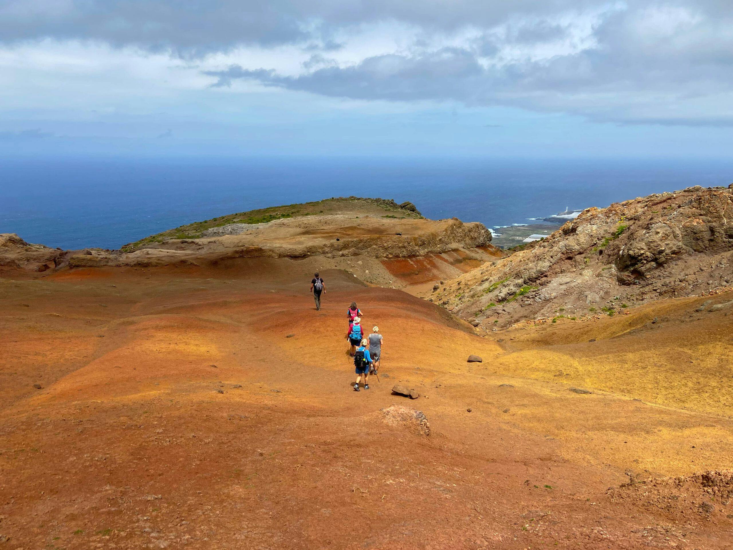
Finally, you pass an old stone circle. To the right, the path leads down the Risco Steig. If you still want to make the small detour to the edge of the cliff with the orange-reddish sandy areas and fascinating views, keep to the left. Continue slightly uphill on the left side of the mountain. After a short while you will reach the first ridge, from where you can already enjoy a really good panoramic view. You now walk downhill on the right side of the ridge and across a large hollow. Here you can enjoy the charming play of colours of the sand. 
Green meadows around Teno Alto
At the end of the hollow, you hike uphill in a kind of wide gully and now reach a break-off edge. You can look down on the Risco trail and see your ascent path on the other side of the valley. You also have the north coast of Tenerife at your feet. When you have enjoyed the magnificent views enough, return to the junction along the same path.

Hikers on the way to the edge of the cliff at Teno Alto
Route section:Junction close to the Risco climb to the starting point on the road
At the junction, keep left and after a short while you will reach the Risco climb. I have described the hike along the Risco Steig in detail here. You can’t miss the path. The Risco Steig first leads you downhill on a steep ridge for quite a while. Finally, the path merges into the slope. From here and throughout the descent, you can continue to enjoy the impressive view. 
View over earth shimmering in all colours near the break-off edge at Teno Alto
Once you are far down, the path gradually flattens out and joins the Barranco de la Torre. You will then reach the place where you went straight ahead (now to the right) on the way down. The circle closes here. You are just before the large water depot, which you quickly reach by turning left. From there it is only a few metres to the starting point on the road.

Hiking trail on the Risco Steig
And finally
I hope you enjoyed this great circular walk around Teno Alto. But as described above under variants, there are many other great hiking options around Teno Alto, Punta Teno and the Risco trail. Whatever you decide, I wish you lots of fun on all your walks,
Dagmar from SiebenInseln